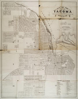
Showing 70550 results

Collections
Image
Print preview View:

70550 results with digital objects Show results with digital objects

Topographic Sheet, Washington, Tacoma Quadrangle, 1898

Washington : Geological Survey
1 map : col. ; 45 x 31 cm. on sheet 56 x 47 cm. "Surveyed in 1894-95." Scale: 1:125,000 Contour interval 50 feet. Relief indicated by contours and spot heights. Datum is mean sea level. "Edition of Nov. 1898" Engraved April 1897 by U.S.G.S. Henry Gannett, Chief Topographer. R. U. Goode, Geographer in charge. Control by W.T. Griswold and U.S. Coast and Geodetic Survey. Topography by G.E. Hyde and R.H. McKee. Diagram depicts which topographers were responsible for which areas of the map.

Map of Oregon, Washington, Idaho, and Part of Montana, 1860

Philadelphia : S. A. Mitchell, Jr.
1 map : hand col. ; 27 x 34 cm. Relief shown by hachures. Shows counties, cities, railroads, routes of wagon trails, and rivers. Scale ca. 1:4,435,000. Lower right: 50. Decorative border. Dated 1860 in bottom margin, but some question whether that might be the date of the original copyright of the base map.

Johnson's Washington and Oregon, 1863

New York: Johnson and Ward
1 map : hand col. ; 32 x 40 cm. Relief shown by hachures. Shows counties, cities, locations of native American tribal groups, and proposed railroad. Scale ca. 1:3,500,000 On verso: portion of "Historical and Statistical View of the United States, 1860", tables for Vermont, Virginia and Washington. In lower right margin: 57. Decorative border. Oregon counties Jackson and Josephine have been interchanged.

Results 91 to 120 of 70550