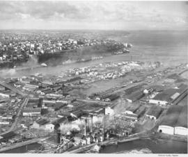
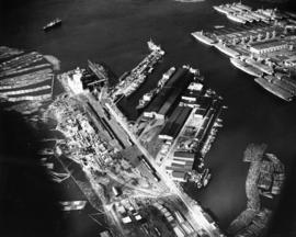
Aerial photographs. A view of Tacoma from the industrial tideflats. The ASARCO stack is in the background. In the immediate foreground is the St. Paul & Tacoma Lumber Company with its many buildings, stacks and scrap burner. East 11th Street comes in from the left and runs across to the right. St. Paul Avenue starts at East 11th Street and takes off to the bottom left corner. The St. Paul & Tacoma Lumber Company is sprawled on both sides of East 11th Street and they had a dock at the end of the land between Middle Waterway and St. Paul Waterway (center,far right). City Waterway is next to Tacoma
Aerial photographs; St. Paul & Tacoma Lumber Co. (Tacoma); Cityscapes; Lumber industry--Tacoma--1940-1950; Smokestacks--Tacoma;
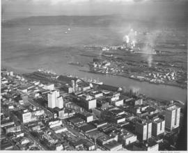
1948 Aerial photographs. A view of the business district of Tacoma to the Tacoma tideflats, Commencement Bay and Brown's Point as the bay joins Puget Sound. The smokestack with the most white smoke is at the St. Regis Paper Company.
Aerial photographs; Cityscapes; Commencement Bay (Wash.); St. Regis Paper Co. (Tacoma)--1940-1950;
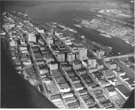
Aerial views of city. This view of downtown is looking north with the high-rise office buildings shown climbing the hill to the west. The 11st Street Bridge crosses the City Waterway on the far right with the industrial Tacoma tideflats on the other side. The Puyallup River enters into Commencement Bay and has left a noticeable line where the fresh water meets the salt. Several ships are docked at Shaffer Terminals lying on the west side of the City Waterway.
Aerial photographs; Cityscapes; Bays--Washington (State); Commencement Bay (Wash.); City Waterway (Tacoma); Rivers--Washington (State); Puyallup River (Wash.); 11th Street Bridge (Tacoma);
This aerial photograph from November 1948 shows the Hooker Electrochemical Company located at 605 Alexander Avenue on the Tacoma tideflats. The waterway above the plant, dotted with log booms, is the Hylebos Waterway. Small houses and businesses line the shore on the other side of the waterway along Marine View Drive. Hooker changed its name to Occidental Chemical Co. in 1982. In 1997 the company was purchased by Pioneer Companies Inc.; the plant closed in 2002. TPL-7977
This aerial view of the Port Industrial Waterway shows the Port of Tacoma facilities north of 11th Street as they appeared in 1948. At the far north end is the Port's grain elevator with a capacity of 2-million bushels. Log booms can be seen in both the Sitcum Waterway, on the left, and in the Port Industrial Waterway, bottom right. The U.S. Naval Station is at the upper right with a flotilla of over 15 moth-balled baby flat top aircraft carriers at dock. TPL-3684
Aerial photographs; Bays--Washington (State); Commencement Bay (Wash.); Port of Tacoma (Tacoma)--1940-1950; United States Naval Station (Tacoma); Logs;
ca. 1948. Aerial view of ASARCO. Lying just beyond the smelter is the Tacoma Yacht Club, followed by the ferry dock. The residential area to the left top is Ruston and the wooded area beyond is Point Defiance Park. TPL-8656
Boathouses; Boats; Tacoma Yacht Club (Tacoma); Mooring; American Smelting & Refining Co. (Tacoma); Smelters--Tacoma--1950-1960; Point Defiance Park (Tacoma);
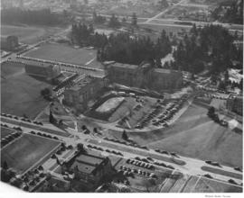
In 1948 College of Puget Sound had the Memorial Fieldhouse built, this building was dedicated in 1949 to those CPS students who died while serving in World War II. In 1949 the President's Residence would be constructed; Dugan, Mock and Morrison were the architects. Aerial view of the College of Puget Sound, Union Avenue and main administration building, in center of photograph.
Education--Tacoma; Streets--Tacoma; Universities & colleges--Tacoma; Aerial photographs; Aerial views; College of Puget Sound (Tacoma)--Buildings;
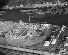
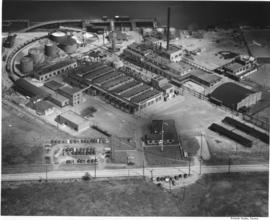
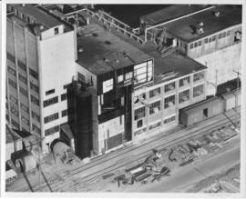
Pennsylvania Salt manufactured the following chemicals: chlorine, caustic soda, sodium hypochlorite, bleaching powder, hydrogen, sodium arsenate, dairy and poultry germicides, special chemical cleaners and laundry and dry cleaning products. Frederick C. Shanaman was the President and General Manager of the company. Aerial view of the Tacoma plant, located at 2901 Taylor Way, in Tacoma's tideflats, near the Turning Basin, which is now known as the Hylebos Basin.
Chemical industry--Tacoma--1940-1950; Chemicals; Industrial facilities--Tacoma; Aerial photographs; Aerial views; Waterfronts; Pennsylvania Salt Manufacturing Co. of Washington (Tacoma);
Aerial view of Pennsylvania Salt Manufacturing Company facilities in Portland, Oregon. President Fred C. Shanaman reported that with the addition of the new facilities for manufacture of chlorine, caustic soda and technical DDT, production at the Portland plant increased substantially in 1947.
Chemical industry--Oregon--Portland; Chemicals; Industrial facilities--Oregon--Portland; Aerial photographs; Aerial views; Waterfronts; Pennsylvania Salt Manufacturing Co. (Portland, Or.);
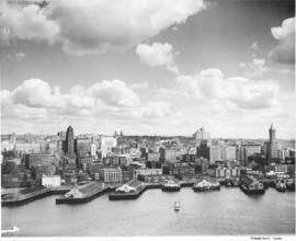
Aerial of Seattle skyline taken from above Elliott Bay. Piers jut into the bay with warehouses on them. Smith Tower is the taller building on the right. TPL-4749
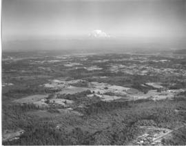
Studio stock negatives. An aerial view of rural Pierce County with open and wooded areas. Small groupings of buildings are dotted over the area. Mount Rainier is seen above the mist.
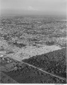
Studio stock negatives. An aerial view of new housing developments. Uncleared land abruptly abuts the housing development. Across the road in the foreground are a few small homes set on what looks like pasture land.
Aerial photographs; Land; Land use--Tacoma--1940-1950; Housing developments--Tacoma--1940-1950;
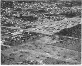
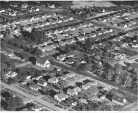
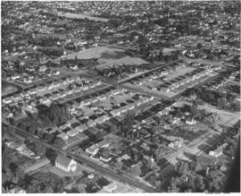
Studio stock negatives. An aerial view of residential neighborhoods in Pierce County. New housing developments with no or few trees are in the foreground.
Aerial photographs; Land; Land use--Tacoma--1940-1950; Housing developments--Tacoma--1940-1950;
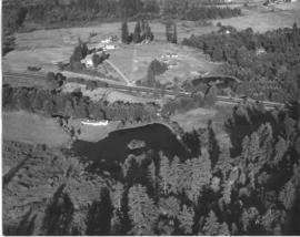
Studio stock negatives. An aerial photograph of a rural area with a highway running across it. A woods and lake are seen on the lower half while several buildings around a cleared area are seen above.
Studio stock negatives. A view from over Commencement Bay, the Tacoma tideflats with the St. Regis Dock and St. Regis Company with Mount Rainier looming in the distance.
Aerial photographs; Land; Land use--Tacoma--1940-1950; St. Regis Paper Co. (Tacoma)--1940-1950; Rainier, Mount (Wash.);
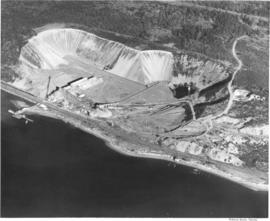
This aerial photograph of the Pioneer Sand and Gravel Company gravel pit was taken in November of 1949. The large gravel pit was located in Steilacoom adjacent what is now University Place; their offices were in Seattle, at 901 Fairview Avenue North. The company specialized in sand, gravel, building materials and "Tru-Mix" concrete. Some years later the pit and the land surrounding it became part of Chambers Creek Properties. In June of 2007 the $21 million Chambers Bay Golf Course opened on this site. TPL-10540
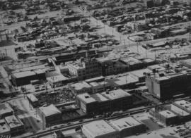
ca. 1949. Aerial view, believed to have been taken in December of 1949, of downtown business district featuring Columbia Breweries (center) on South "C" Street where the sprawling plant covered 3-4 acres. Snow is gradually melting over the rooftops on this sunny winter day. The Hunt & Mottet Co. building is at the right foreground.
Aerial views; Aerial photographs; Columbia Breweries, Inc. (Tacoma)--1940-1950; Brewing industry--Tacoma--1940-1950; Hunt & Mottet Co. (Tacoma); Commercial streets--Tacoma--1940-1950;
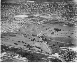
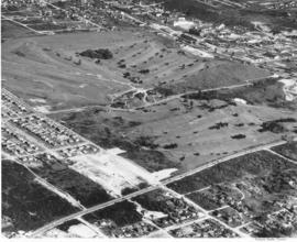
An aerial view of Allenmore Golf Course that includes the residential neighborhoods around the golf course. In the background can be seen the taller buildings of the Tacoma business district and beyond that, Commencement Bay.
Allenmore Golf Club (Tacoma); Golf--Tacoma--1950-1960; Sports & recreation facilities--Tacoma; Aerial photographs; Land use--Tacoma;
Aerial view of Allenmore Golf Course. The club house is seen in the middle of the large, newly landscaped golf course. The fairways are seen switch back style through the foreground and far background. New housing sub-divisions are seen across So. 19th Street.
Allenmore Golf Club (Tacoma); Golf--Tacoma--1950-1960; Sports & recreation facilities--Tacoma; Aerial photographs; Land use--Tacoma;
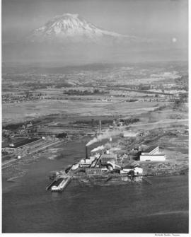
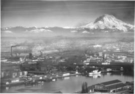
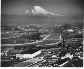
Scenic view of Mount Rainier beyond the Tacoma tideflats. City Waterway (later renamed Foss Waterway) lies in the foreground with Centennial Flouring Mills on the lower side of it and Uion Oil with their "76" storage tanks, Shell Oil, Northwest Door Company, and Richfield Oil lining the opposite side. The Puyallup River zig-zags into the distance beyond the smokestacks of St. Paul & Tacoma Lumber Company. This photograph was taken using an aerial camera. TPL-9862
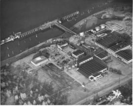
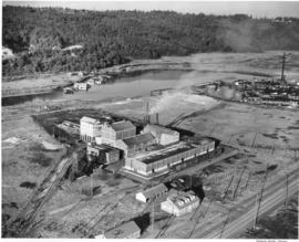
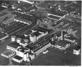
An aerial view of the Feltrok Insulation Manufacturing Company taken at 7 p.m. June 9, 1950. The company was located on the Tacoma tideflats. Pennsylvania Salt Manufacturing Company is seen on the right. Feltrok was purchased by the American Rock Wool Corporation in 1952. About 35 persons were employed in the Tacoma operation at that time. (Tacoma Reporter, 7/21/1952, p.3)
Aerial photographs; Feltrok Insulation Manufacturing Co. (Tacoma); Industrial facilities--Tacoma--1950-1960; Pennsylvania Salt Manufacturing Co. of Washington (Tacoma);
An aerial view of St. Paul and Tacoma Lumber Company. Colonel Chauncey Griggs, Addison Foster, Henry Hewitt, Jr. and Charles Hebard Jones purchased 83,000 acres of timber in 1888 from the Northern Pacific Raillroad company in the largest purchase of timberland in the nineteenth century. Then they built a giant sawmill on "The Boot", a low island off the main tideflats, bordered by branches of the Puyallup River and Commencement Bay. They built the first standard-guage logging railroad and introduced the band-saw to Pacific Northwest lumber operations. They built the St. Paul & Tacoma Lumber Company. (The Mill on the Boot, Murray Morgan)
Aerial photographs; Lumber industry--Tacoma--1950-1960; St. Paul & Tacoma Lumber Co. (Tacoma);
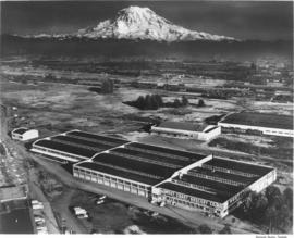
Copy of aerial view of West Coast Grocery Company with Mount Rainier in the background. West Coast Grocery was an outlet for national and local brand foods to be shipped throughout the Pacific Northwest, Hawaii and Alaska. The company had served Tacoma and Alaska since 1887. Their brand name, Amocat (Tacoma spelled backwards), was a guide to shoppers to quality food products. Ordered by West Coast Grocery, Chet Chumington. (TNT, 2/13/1951, p.C-2)
Aerial photographs; Commercial facilities--Tacoma; West Coast Grocery Co. (Tacoma); Business enterprises--Tacoma--1950-1960; Storehouses--Tacoma; Rainier, Mount (Wash.); Mountains;
This aerial view of part of the sprawling St. Paul & Tacoma Lumber Company complex with Mount Rainier in the background dates from September of 1950. St. Paul & Tacoma with its many buildings, smokestacks and burners was located in the southwest section of the Tacoma tideflats near the Puyallup River; their headquarters were at 1220 Saint Paul Avenue. The white bridge near the center of the image crossing the channelized Puyallup River is the Lincoln Avenue bridge. Two railroad bridges and the Pacific Highway (U.S. Hwy 99) bridge can be seen further up the river.
Aerial photographs; St. Paul & Tacoma Lumber Co. (Tacoma); Cityscapes; Lumber industry--Tacoma--1950-1960;
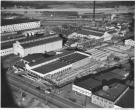
Aerial view shows progress being made on new construction for the St. Regis Paper Company in September, 1950. Established as a company in 1899, St. Regis was open for business in Tacoma in 1928. Rebuilt and modernized in 1936, St. Regis bought additional acreage from the St. Paul Tacoma Lumber Company in 1947 to add a paper mill and multi wall bag plant. According to the St. Regis 1950 annual report, Tacoma's expansion of their pulp mill would enlarge the pulp capacity from 115,000 to 135,000 tons a year. The new capacity will be in production in 1951.
St. Regis Paper Co. (Tacoma)--1950-1960; Paper industry--Tacoma--1950-1960; Factories--Tacoma--1950-1960; Progress photographs--1950-1960; Aerial photographs;
Aerial view, 1000 foot elevation, of Sumner manufacturing division of Fleischmann's Yeast taken in September, 1950. Photograph taken at 5 p.m.; evening shadows start to creep over the large plant. Fleischmann's Yeast was part of Standard Brands, Inc., and is still sold in grocery stores today. Photograph ordered by Standard Brands' New York City office.
Fleischmann's Yeast (Sumner); Standard Brands, Inc. (Sumner); Aerial photographs;
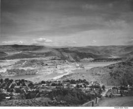
Scenic views from Eastern Washington. An aerial view of the housing area across the Columbia River from the utility facilities at Grand Coulee Dam. Mason City was built on one side of the river during the dam construction and Engineer's Town grew on the opposite side. This view shows the land forms above the river into the distance.
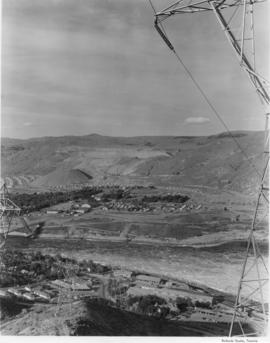
Scenic views from Eastern Washington. An aerial view of the town on the far side of the river and Grand Coulee Dam plant facilities in the foreground. A tower for delivering electric power from the plant is seen on the right as others climb the hill from below. Electrical energy generated at the power plant at 13,800 volts is stepped up to 230,000 volts for long distance transmission by groups of transformers. High tension lines from the transformers are carried on steel towers over the powerhouse and up the canyon walls to a switchyard, where facilities are provided for interconnecting generating units and transmission lines. (Grand Coulee from "Hell to Breakfast", Fred O. Jones)
Aerial photographs; Columbia River (Wash.); Utility poles; Hydroelectric power;