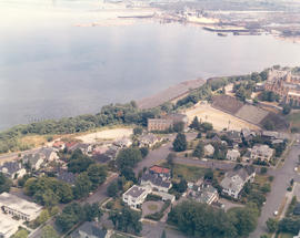
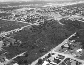
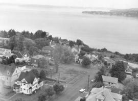
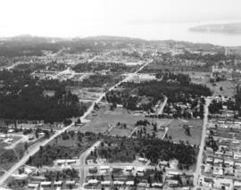
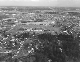
1969 Richards stock footage. Aerial view of Tacoma's north end featuring the No. 4th & D St. neighborhood. The Washington State Historical Building is located high above its neighbor, the Stadium Bowl, near the center of the photograph. The French Chateau-styled Stadium High School is on the extreme right edge of photograph.
Aerial views; Neighborhoods--Tacoma--1960-1970; Washington State Historical Building (Tacoma); Stadium Bowl (Tacoma); Stadium High School (Tacoma);
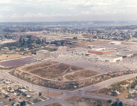
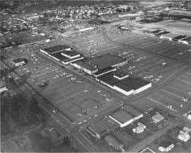
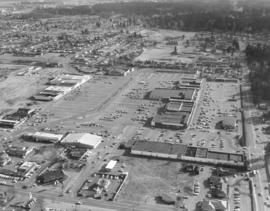
1969 Richards stock footage. View by air of the Tacoma Mall Shopping Center and newly built Tacoma Mall Office Building on July 1, 1969. A new addition to the Tacoma Mall Shopping Center was the 6-story Tacoma Mall Office Building, 4301 So. Pine. Designed by Olympia architects Bennett & Johnson and built by Cascade-Olympic Construction, the 2.7 million dollar structure was one of the first new major office buildings to be built in Tacoma in many years. The building was 90,000 square feet of reinforced concrete and came equipped with soundproof walls and air conditioning. Three high-speed elevators could be utilized to transport quickly customers and staff alike. The large lot provided plenty of free parking. It was conveniently located just off Pine St. and like the rest of the mall, freeway access was close by. The Tacoma Mall Office Building is still in service 36 years after its grand opening in March of 1969. Also shown above are the major stores of the Tacoma Mall: the Bon Marche, Nordstrom Best, and J.C. Penney. (TNT 8-4-68, A-11, TNT 10-27-68, B-11)
Aerial views; Tacoma Mall Office Building (Tacoma); Office buildings--Tacoma--1960-1970; Tacoma Mall Shopping Center (Tacoma); Shopping centers--Tacoma; Bon Marche (Tacoma); Nordstrom Best (Tacoma); J.C. Penney Co. (Tacoma);
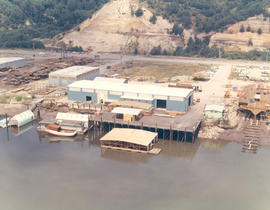
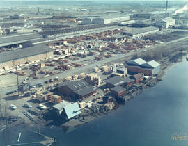
1969 Richards stock footage. Aerial look at newer Western Boat Building plant on Hylebos Waterway. The shipbuilding firm had moved to a seven-acre site on Marine View Dr., vacating the temporary quarters at the Port Industrial Yard it had occupied since fire destroyed their longtime plant on 11th St. One boat is under construction at far right edge of photograph.
Aerial views; Western Boat Building Co. (Tacoma); Boat & ship industry--Tacoma--1960-1970; Boats--Tacoma--1960-1970; Hylebos Waterway (Tacoma);
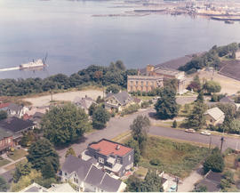
1969 Richards stock footage. Aerial view of No. 4th & D neighborhood during the summer of 1969. The Washington State Historical Society building on Stadium Way is the neo-classical structure next to Stadium Bowl. Many homes with Commencement Bay views were built in this neighborhood. A boat is seen streaming toward shore; this is believed to be the snagboat, the W.T. Preston, which was the last working sternwheeler on Puget Sound.
Aerial views; Boats--Tacoma--1960-1970; Neighborhoods--Tacoma--1960-1970; Washington State Historical Building (Tacoma); Stadium Bowl (Tacoma);
1969 Richards stock footage. Closer look at the large wooded area near Sixth Ave., James, No. 11th and No. 9th. Sixth Ave. is near the top half of photograph; Swasey branch library is near intersection of Howard and Sixth. No. 9th is street running nearly horizontal which appears to be swallowed by the woods. 11th St., near the right corner, intersects James which also appears to dead end in the woods.
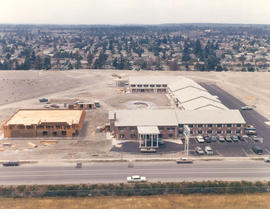
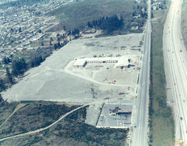
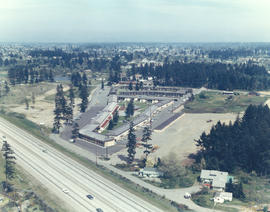
1969 Richards stock footage. Closer aerial view of the Rodeway Inn of America under construction in the summer of 1969. Located near So. 72nd and the freeway, the Rodeway Inn would provide comfortable lodgings for the road-weary traveler. The two-story units were built in a modified U-shape. Constructed on five acres leased from Hillcrest Properties, the 130-unit complex was owned by Northwest Motel Co., Seattle. It would open for business in November of 1969. (TNT 11-2-69, D-14)
Aerial views; Rodeway Inn of America (Tacoma); Motels--Tacoma--1960-1970; Building construction--Tacoma--1960-1970;
1969 Richards stock footage. A new motor inn was being built in the summer of 1969 at 6802 So. Sprague Ave., close to So. 72nd and the freeway. The Rodeway Inn of America was part of a large nationwide chain of motels. Its blue and white logo was a familiar sign to budget conscious travelers who could be assured of comfortable rooms and reasonable prices. Built at a cost of 1.25 million dollars, the 130-unit complex was managed by Johnny H. Lambert. It would offer a restaurant/lounge, heated swimming pool, convention and banquet facilities and meeting rooms. The luxury motel hotel would be open for business in early November, 1969. (TNT 11-2-69, D-14)
Aerial views; Rodeway Inn of America (Tacoma); Motels--Tacoma--1960-1970; Building construction--Tacoma--1960-1970; Signs (Notices);
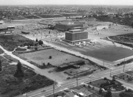
Aerial view of Tacoma Mall Shopping Center and Tacoma Mall Office Building. This July, 1969, view of the popular Tacoma Mall Shopping Center and newly opened six-story Tacoma Mall Office Building shows that there is still much room for development of the center. New stores would be built on both sides of the Bon Marche (red building), first occupant of the mall. The dirt acreage bordering the parking lot would eventually become extended parking for the mall and the location of Frederick & Nelson's. The Post Office would build its Evergreen Station also on Pine Street, just beyond the left edge of the photograph. Color photograph ordered by Center Offices, Inc.
Aerial views; Tacoma Mall Shopping Center (Tacoma); Shopping centers--Tacoma; Tacoma Mall Office Building (Tacoma); Parking lots--Tacoma--1960-1970; Bon Marche (Tacoma);
Aerial photograph of the North end neighborhood about No. 4th & "D" in June of 1969. Homes in this area would have exquisite views of Commencement Bay. A large vacant lot on the northwest corner of No. 4th & "D" might be ready for building soon. Home with treed lot in rear of the vacant lot is 401 No. "E;" empty lot is actually 402-08 No. "D;" and home with portico across the street from lot is 401 No. "D." Photograph ordered by award winning architect Robert Billsbrough Price.
Aerial views; Neighborhoods--Tacoma--1960-1970; Houses--Tacoma; Commencement Bay (Wash.);
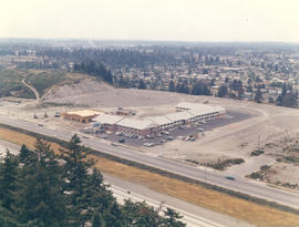
1969 Richards stock footage. Looking quite a bit different in May of 1969, the area around So. 72nd and the freeway was starting to be developed commercially. The new Rodeway Inn of America was under construction at 6802 So. Sprague, close to the freeway. Travelers could easily exit the freeway to find comfortable lodgings. A Standard Oil station was conveniently located nearby. The 130-unit luxury motor hotel opened in early November, 1969, with a 90-unit addition planned. (TNT 11-2-69, D-14)
Aerial views; Building construction--Tacoma--1960-1970; Rodeway Inn of America (Tacoma); Motels--Tacoma--1960-1970; Automobile service stations--Tacoma--1960-1970;
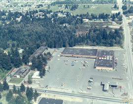
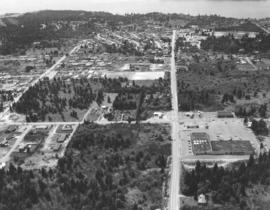
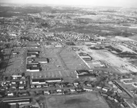
1969 Richards stock footage. Aerial view of 40th & Bridgeport neighborhood, featuring the University Village Shopping Center. Designed by Lyle Swedberg & Associates and built by James Kirkebo & Son, Inc., the shopping center opened in October of 1967. The main occupants were the Food King supermarket and Don's Village Drugs. Ample free parking was provided for customers who could enjoy "one-stop" shopping in the center for groceries, prescriptions, apparel, gasoline and restaurant cooking.
1969 Richards stock footage. Closer look by air at the 7-month-old Aladdin Apartments, located in the city's south end at 2112 So. 90th St. The upscale apartment complex, built by developer Oscar Hokold, was opened in September of 1968. Residents of the one and two bedroom units enjoyed such amenities as spacious bedrooms, wall-to-wall carpeting, soundproofing and dishwashers. All had views of the landscaped greens and swimming pool area.
1969 Richards stock footage. Aerial view of the Aladdin Apartments, 2112 So. 90th St., which were completed in 1968. Built by local developer Oscar Hokold, the units were all electric and rented for $135 and up. The Aladdin was centrally located, close to the freeway and mere minutes from the Tacoma Mall.
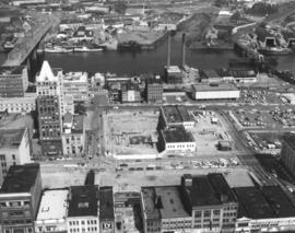
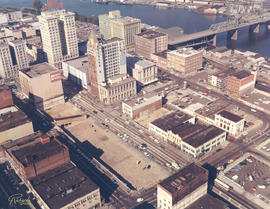
This aerial view of downtown Tacoma from May of 1969 centers on the block bordered by South 12th & 13th, and Pacific & A Streets; this block was the future home of the Bank of Washington Plaza. Most of the buildings on the block have been demolished. The empty lot across Pacific (toward the bottom of the photo) will be the site of the Park Plaza South Parking Garage, 1137 Commerce Street. The parking garage was built in 1970. The two tall chimneys, top center, belong to the Tacoma Steam Plant No. 1 (to the left) and the Consumer Central Heating Company. The bridge at the right crossing the the City (now Thea Foss) Waterway is the old 15th Street Railroad Bridge. (TNT 11-20-68, p. 1)
Aerial views; National Bank of Washington (Tacoma); Banks--Tacoma; Building construction--Tacoma--1960-1970; City Waterway (Tacoma);
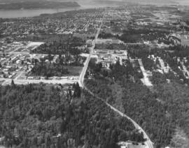
Closer look by air on April 29, 1969, of the 40th & Bridgeport Way area in University Place. 40th is the prominent road running vertically near the right side of the photograph; it is intersected by Bridgeport Way. University Place water tower is at very bottom to the left of 40th; University Village Shopping Center with large parking lot is on the right. Photograph ordered by Puget Sound National Bank.
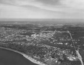
This is the Menlo Park and Sunset Beach area. Gravelly Lake Dr. is believed to be the road running horizontally surrounded by trees and homes. April, 1969, aerial views of the University Place area requested by Puget Sound National Bank. TPL-9241
Aerial view of 40th & Bridgeport area in University Place. University Place's 400,000 gallon water tower is near mid-center; it is located on W. 40th between Bridgeport and Anderson. University Village Shopping Center featuring the Food King supermarket is slightly above and to the right of the water tower. Although University Place was becoming more developed by the late 1960's, there was still an abundance of wooded areas. Photograph requested by Puget Sound National Bank.
Aerial view of Bridgeport Way toward the Sound taken on April 29, 1969. Bridgeport Way is meandering through the woods as it makes a slight curve toward the center of the photograph. 40th St. intersects Bridgeport at upper center with the University Village Shopping Center and water tower visible. Photograph ordered by Puget Sound National Bank.
This is how the area around South 72nd Street and I-5 appeared by air in March of 1969. Wapato Lake off of Alaska Street is the large body of water nestled among trees. The cluster of buildings on the far left is the Roadway Inn of America under construction at 6802 So. Sprague. Nearby is a Standard Oil station. This photograph was taken for the Wapato Lake Development Company who had sought permission from the City Planning Commission in early February, 1969, to build a 234-unit lowrise apartment complex on a 12-acre site north of South 72nd between Alaska Street and the freeway. This would entail rezoning and be subject to approval from the city council. We find no record that this complex was built. (TNT 2-4-69, p. 10) TPL-9697
Aerial views; Wapato Lake (Tacoma); Express highways--Tacoma--1960-1970; Rodeway Inn of America (Tacoma);
1969 Richards stock footage. Color aerial view of Export Pacific Co. By 1969, Export Pacific's address had changed from 900 Milwaukee Way to 1942 E. 11th, next door to the Brown & Haley Distribution Division. Still headed by Chauncey L. Griggs, the firm remained in the lumber export business while sharing the address with the Export Pacific Grain Co.
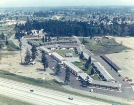
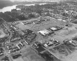
Aerial view, looking north, of the Villa Plaza Shopping Center and various Lakewood neighborhoods on February 26, 1969. The shopping center, with its vast parking lot, is in the center of the photograph. At the bottom left corner is part of Clover Park High School with ball field. A portion of the Lakewood Center can be spotted on the left side of the photograph. Lockburn Junior High, Flett Dairy and Clover Park Voc-Tech are also visible. The Villa Plaza Shopping Center would be renamed the Lakewood Mall in 1989. Photograph ordered by Puget Sound National Bank.
Aerial views; Villa Plaza Shopping Center (Lakewood); Shopping centers--Lakewood--1960-1970; Neighborhoods--Lakewood--1960-1970;
1969 Aerial view of the Villa Plaza Shopping Center. Prior to the construction of the massive Tacoma Mall, there was the Villa Plaza Shopping Center in Lakewood. The Villa Plaza was built in 1957 on the site of the former 200-acre Visitation Villa. By the mid-50's, Lakewood was growing in leaps and bounds and there was a need for more convenient shopping in the suburbs. The Villa Plaza was not the first "one-stop" shopping center in the area--that honor would go to the Lakewood Center--but it had more room for development and most importantly, plenty of free parking. Ads for the Villa Plaza constantly promoted the availability of its 4000 car parking lot. Major downtown stores J.C. Penney, Woolworth and Rhodes would open branches in the Villa Plaza, therefore lessening the necessity of suburban shoppers to venture downtown. Unlike the Tacoma Mall, which would open in 1965, the Villa Plaza was not contained under one roof although many stores were clustered within short walking distances. Photograph ordered by Puget Sound National Bank.
Aerial views; Villa Plaza Shopping Center (Lakewood); Shopping centers--Lakewood--1960-1970;
Aerial view of the Villa Plaza Shopping Center and surrounding Lakewood neighborhoods on February 26, 1969. Steilacoom Lake is in the background. St. Francis Cabrini Catholic Church property near left bottom corner. Tenzler Library (now Lakewood Library) close to Gravelly Lake Dr. on extreme left edge. Photograph ordered by Puget Sound National Bank.
Aerial views; Villa Plaza Shopping Center (Lakewood); Shopping centers--Lakewood--1960-1970; Lake Steilacoom (Wash.); Neighborhoods--Lakewood--1960-1970;
View by plane of Villa Plaza Shopping Center and surrounding Lakewood neighborhoods on February 26, 1969. The Villa Plaza's 4000-car parking lot and congregation of large stores were major attractions. In 1969, the shopping center was twelve years old and facing competition from the younger Tacoma Mall Shopping Center. There was still room for expansion for the Lakewood facility but it lacked direct freeway access that the Tacoma Mall enjoyed. Photograph ordered by Puget Sound National Bank.
Aerial views; Villa Plaza Shopping Center (Lakewood); Shopping centers--Lakewood--1960-1970; Neighborhoods--Lakewood--1960-1970;
Another aerial view in a series of photographs of Lakewood's Villa Plaza Shopping Center taken on February 26, 1969. A McDonald's restaurant has sprouted up near an entrance to the large shopping center. A notable feature of the Villa Plaza is the immense parking lot, capable of holding 4000 cars. Customers could choose to park their vehicles near any of the 30+ stores and not worry about feeding the meter. Photograph ordered by Puget Sound National Bank.
Aerial views; Villa Plaza Shopping Center (Lakewood); Shopping centers--Lakewood--1960-1970; Parking lots--Lakewood; McDonald's (Lakewood);
February 24, 1969, aerial view of Holiday Inn, Fife. The large hotel, 3518 Pacific Hwy. E., was located on Pacific Hwy. across the street from Buck & Son Tractor. It provided plenty of parking for its guests and a rectangular swimming pool nestled between the hotel buildings. Swimmers and those relaxing under the table umbrellas could experience a sense of privacy from busy highway traffic. A large grassy area was available for guests - and small children - to stretch their legs. Photograph ordered by Sherwood & Roberts, Inc.
Aerial photographs; Holiday Inn (Fife); Hotels--Fife;
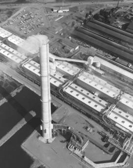
Aerial view of new rod mill at Kaiser Aluminum on February 24, 1969. Smoke billows from the new 500-foot stack. Kaiser's new aluminum rod mill began operations in December, 1968. Photograph ordered by Kaiser Engineers, Inc.
Aerial photographs; Kaiser Aluminum & Chemical Corp. (Tacoma); Industrial facilities--Tacoma--1960-1970; Aluminum industry--Tacoma--1960-1970;
ca. 1968. 1968 Richards stock footage. City Center. View by air on a sunny day in 1968 of Tacoma's City Center. This is in the vicinity of 12th & Pacific Ave. There is a large cleared area ready for construction down the street from the Puget Sound National Bank and National Bank of Washington. Other notable sights include the 11th Street Bridge crossing the City (now Thea Foss) Waterway, the Tacoma and Perkins Bldgs. near the entrance to the bridge, the Washington Building with red neon "Bank of California" sign, Peoples department store, and Rust Building.
Aerial views; Commercial streets--Tacoma--1960-1970; Puget Sound National Bank (Tacoma); National Bank of Washington (Tacoma); City Waterway (Tacoma); 11th Street Bridge (Tacoma); Tacoma Building (Tacoma); Perkins Building (Tacoma); Peoples (Tacoma);
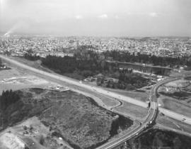
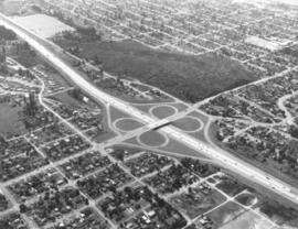
ca. 1968. Interstate 5 was not yet five years old in 1968 when the Tacoma City Photographer shot this aerial view of the South 56th Street cloverleaf. The area has seen major growth in just over thirty years. Tacoma Mall Boulevard, formerly South Ferry Street, runs parallel to the freeway at the right. The undeveloped land at center is the area known as Wapato Hills.
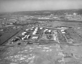
November, 1968, aerial view of U.S. Oil & Refining plant on Tideflats. Petroleum storage tanks dot the landscape, part of the 120-acre plot owned by the U.S. Oil & Refining Co. The plant was built on land just south of Lincoln Ave. Closest waterway would be the Port Industrial Waterway. Photograph ordered by U.S. Oil & Refining.