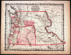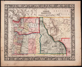
Map of Oregon, Washington, Idaho, and Part of Montana, 1860
- Item
- 1860
Part of Map Collection
Philadelphia : S. A. Mitchell, Jr.
1 map : hand col. ; 27 x 34 cm. Relief shown by hachures. Shows counties, cities, railroads, routes of wagon trails, and rivers. Scale ca. 1:4,435,000. Lower right: 50. Decorative border. Dated 1860 in bottom margin, but some question whether that might be the date of the original copyright of the base map.