Showing 41039 results

Collections
Item With digital objects
Advanced search options
Print preview View:

G73.1-009

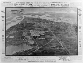
ca. 1910. In March of 1910, Tallman-Thompson Co., Inc. hired pioneer aviator Charles K. Hamilton to take a birds eye view of Tacoma from his 8 cylinder Curtis bi-plane. Tallman-Thompson, located at 111 So. 10th, was the owner of Lakewood Subdivisions. The company owned 3,000 lots in Lakewood, being sold at $125 each and up. The company had 5,000 18x24 copies of the aerial view printed up and gave them away as promotion. On the top left is a quote from Success magazine picking Tacoma as the next New York and predicting that Tacoma would grow to a population of 5 million. The Tallman-Thompson Co. felt that the most growth would be through Lakewood, "the gateway to the Lakes." On the sides of the picture are predicted statistics on population, financial and industrial growth. (TDL 3/20/1910, PG. 41)


Tallman-Thompson Co., Inc. (Tacoma); Promotional materials; Aerial photographs;

C155602-1

ca. 1911. Street scene in Grandview, Washington. Copy of customer print. Asahel Curtis traveled to Grandview in Yakima County in 1911 to photograph several areas of town. Print #20733 was taken of the business district including the Grandview State Bank. Several men are pictured outside the bank while three horse-drawn buggies go by. Photograph ordered by Dr. C.B. Coulter of the University of Puget Sound. (University of Washington Digital Collections)


Commercial streets--Grandview; Grandview State Bank (Grandview); Carriages & coaches--Grandview;

C155602-4

ca. 1911. Copy of customer print. This is possibly the small town of Grandview, Washington, about 1911. Photographer Asahel Curtis, brother of Edward Curtis of Seattle, would spend years photographing the Klondike Gold Rush, Washington State's historical events and people, and its natural resources, especially Mount Rainier. In 1911 he traveled to Grandview and took several pictures of the town and surrounding areas. #20734 is a view of scattered small houses and possibly crops growing between them. Photograph ordered by Dr. C.B. Coulter of the University of Puget Sound.


Houses--Washington;

C155602-2

ca. 1911. Copy of customer print. This is the Grandview Lateral Canal located in Yakima County. Asahel Curtis of Seattle traveled to Grandview, Washington, in 1911 and photographed several scenes of the rural landscape. #20740 shows the intake for irrigation water. A man in a horse-drawn buggy pauses on the unpaved road before crossing the bridge. There is no other traffic in sight. Several farmhouses are in the distance. Photograph ordered by Dr. C.B. Coulter of the University of Puget Sound. (University of Washington Digital Collections)


Bridges--Grandview; Irrigation canals & flumes--Grandview; Carriages & coaches--Grandview;

Map of Washington, 1911

George F Cram Company
1 map; 34 x 41 cm. From page 178-179 of Cram's unrivaled atlas of the world. Relief shown by hachures. Shows counties, cities and railroads. Scale ca. 1:1,300,000 On verso: "Alaska" and "Idaho" maps. In lower margin: 178, 179.

C155602-5

ca. 1911. Copy of customer print. Men digging small ditch connecting to water-filled narrow canal. Asahel Curtis print #20765. This is a photograph possibly taken in Grandview, Washington, about 1911. Photographer Asahel Curtis had traveled to the rural Yakima County area to take photographs of the town and surrounding vicinity. Photograph ordered by Dr. C.B. Coulter of the University of Puget Sound.


Digging; Canals;

C155755-1

ca. 1911. Copy of customer print. Arthur Magill in profile. Mr. Magill was a past Exalted Ruler of the Tacoma Elks Lodge No. 174. According to the April 6, 1911, Tacoma Daily Ledger, he was installed as Exalted Ruler on April 5, 1911. Photograph ordered on February 3, 1969, by the Benevolent and Protective Order of Elks, Tacoma Lodge No. 174.


Magill, Arthur; Benevolent and Protective Order of Elks, Tacoma Lodge No. 174 (Tacoma);

Rand McNally New Commercial Atlas Map of Washington, 1912

Chicago : Rand McNally.
1 map : col. ; 48 x 66 cm. State capitals and County seats identified by symbols. A key to Railroads is located in the lower left. Shows Railroads and Steamship lines. Includes index of cities with a population of 1,000 or more. At top: "Library atlas of the world." Relief shown by hachures and spot highlights. Scale 1 in. = 15 miles [ca. 1:950,400].

C59415-3

ca. 1912. The name painted on the side of the brewery is the Columbia Brewing Company. The building was built in 1900 when the brewery was established. Like most early breweries this building was tall and took advantage of gravity in moving materials through the brewing process. Grain storage and milling was often located high in a brewery on the 3rd or 4th floor. The copper brew kettle was commonly located beneath the mash tun at ground level. Copies of old prints ordered by Columbia Breweries in 1951. (Brewed in the Pacific Northwest, Gary and Gloria Meier)


Brewing industry--Tacoma--1910-1920; Columbia Brewing Co. (Tacoma);

Mountaineers Scrapbook, 1912 to 1916, p. 15

The Mountaineers Summer Outing, July 20, 1912-August 10, 1913 Scrapbook, pg. 15. From captions, clockwise: Fall in the grub-line, every one in the grub-line. The Mountaineers are feeling very frisky and gay; Bacon and macaroni, pancakes and pickled pony, Everyone is hungry to-day

Mountaineers Scrapbook, 1912 to 1916, p. 19

The Mountaineers Summer Outing, July 20, 1912-August 10, 1913 Scrapbook, pg. 19. From captions, clockwise: Steamboat Prow. When we stood together on the mountain top, with The Mountaineers, We gave three cheer as the flag went up, and floated in the mountain breeze

Results 181 to 210 of 41039