- Item
- 1911-1916
Part of Astoria Iron Works Records
68627 results with digital objects Show results with digital objects
Part of Astoria Iron Works Records
Part of Richards Studio Photographs
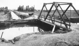
ca. 1911. Copy of customer print. This is the Grandview Lateral Canal located in Yakima County. Asahel Curtis of Seattle traveled to Grandview, Washington, in 1911 and photographed several scenes of the rural landscape. #20740 shows the intake for irrigation water. A man in a horse-drawn buggy pauses on the unpaved road before crossing the bridge. There is no other traffic in sight. Several farmhouses are in the distance. Photograph ordered by Dr. C.B. Coulter of the University of Puget Sound. (University of Washington Digital Collections)
Bridges--Grandview; Irrigation canals & flumes--Grandview; Carriages & coaches--Grandview;
Part of Map Collection
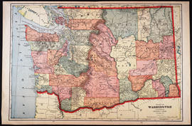
George F Cram Company
1 map; 34 x 41 cm. From page 178-179 of Cram's unrivaled atlas of the world. Relief shown by hachures. Shows counties, cities and railroads. Scale ca. 1:1,300,000 On verso: "Alaska" and "Idaho" maps. In lower margin: 178, 179.
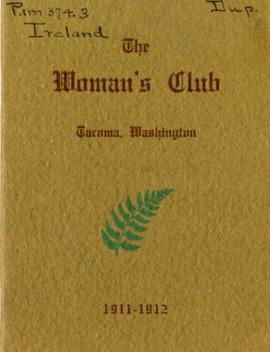
The Woman's Club Yearbook, 1911-1912 "Ireland"
Part of Women's Study Clubs Records
Yearbook for The Woman's Club on the theme of "Ireland."
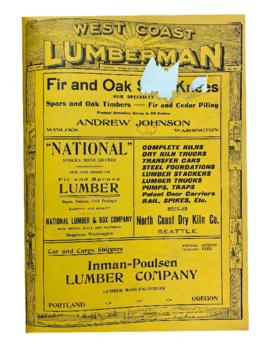
West Coast Lumberman, Vol. 22 No. 263
Part of West Coast Lumberman
Part of General Photograph Collection
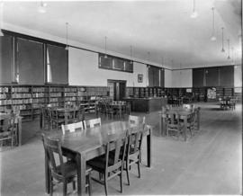
ca. 1911. Interior of the original South Tacoma Branch of the Tacoma Public Library (TPL.) This was the first branch library in a building of its own in the TPL system. The idea for the branch evolved from the Women's Christian Temperance Union's (WCTU) reading room. The reading room was started in 1905 in the Grieb building on South Union Ave. (now South Tacoma Way) to lure young men away from the rowdy saloons of South Tacoma. Miss Lillian L. Beattie (later Mrs. James Smyth) served as the first librarian from 1905-1907. She originally worked for no wages, later to be paid $10 a month by the WCTU and $15 a month by TPL. Finally the Tacoma Public City Librarian was authorized to spend up to $30 a month to maintain a library branch and the library moved to two more locations until, in 1909, $5000 was earmarked for the construction of a branch library building. The South Tacoma branch was dedicated on May 3, 1911. It was designed by George Gove and built at a cost of $3,620. (TNT 11/29/1959, pg. 4)
Tacoma Public Library, South Tacoma Branch (Tacoma); Public libraries--Tacoma--1910-1920;
Part of General Photograph Collection
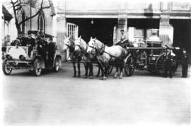
ca. 1911. Engine House No. 5 at 1215-17 South I Street. Engine House No. 5 received an 80-horsepower Seagrave combination hose and chemical wagon in 1911. The station was in service from 1890 to 1935. (Talbot & Decker, 100 Years of Firefighting in the City of Destiny, Tacoma, Washington, p. 52, p. 18)
Tacoma Fire Department (Tacoma); Tacoma Fire Department, Fire Station No. 5 (Tacoma);
Part of Richards Studio Photographs
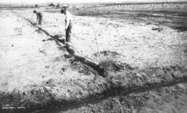
ca. 1911. Copy of customer print. Men digging small ditch connecting to water-filled narrow canal. Asahel Curtis print #20765. This is a photograph possibly taken in Grandview, Washington, about 1911. Photographer Asahel Curtis had traveled to the rural Yakima County area to take photographs of the town and surrounding vicinity. Photograph ordered by Dr. C.B. Coulter of the University of Puget Sound.
Digging; Canals;
Part of Richards Studio Photographs
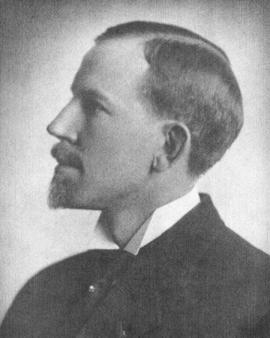
ca. 1911. Copy of customer print. Arthur Magill in profile. Mr. Magill was a past Exalted Ruler of the Tacoma Elks Lodge No. 174. According to the April 6, 1911, Tacoma Daily Ledger, he was installed as Exalted Ruler on April 5, 1911. Photograph ordered on February 3, 1969, by the Benevolent and Protective Order of Elks, Tacoma Lodge No. 174.
Magill, Arthur; Benevolent and Protective Order of Elks, Tacoma Lodge No. 174 (Tacoma);
Part of Local Writings and Publications
Part of General Photograph Collection
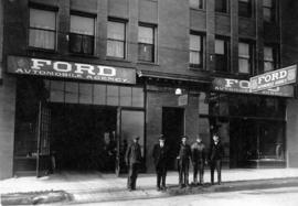
ca. 1911. The Ford Automobile Agency was apparently only at 1210-16 Tacoma Ave. So. for one year, 1911, with Egbert M. Streeter as proprietor. It is not certain which, if any, of the above photographed men, was Mr. Streeter. He would pass away on May 21, 1939. The 1912 City Directory shows the Ford Automobile Agency had relocated to 223 So. "K" (Martin Luther King Jr. Way), a newly built facility. W. C. Baldwin was listed as manager.
Ford Automobile Agency (Tacoma); Automobile dealerships--Tacoma--1910-1920; Ford Automobile Agency (Tacoma)--Employees;
Part of General Photograph Collection
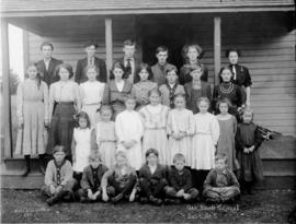
ca. 1911. The student body of Oak Knoll School, District No. 5, posed for a group picture in 1911. Front row: Frank Otremba, John Dilley, Ed Patzke, _ Bevins, Waldo Smith, George Goymer. Second row: Laura Pflugmacher, Mildred Carter, Almira Kawelmacher, Irene Smith, Thelma Carter, Zelda Lenz, Evelyn Laverne and Ella Otremba. Third row: Edna Kawelmacher, Ida Smeiden, Minnie Patzke, Louise Laverne, Elizabeth Otremba, Fred Otremba, George Carter and Freida Jeschke. Fourth row (8th grade): Homer Hawk, John Pflugmacher, Oscar Lindahl, John Carter, Helen Dilley. Alexa McGilvary was the teacher. Oak Knoll School was located east of Roy on Harts Lake Loop Road. It was on the west side of 8th Avenue South, going toward the junction with 288th Street South.
Oak Knoll School; Students--1910-1920;
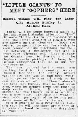
"Little Giants" to Meet "Gophers" Here (TDL)
Part of Clipping and Reference Files
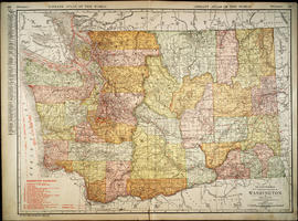
Rand McNally New Commercial Atlas Map of Washington, 1912
Part of Map Collection
Chicago : Rand McNally.
1 map : col. ; 48 x 66 cm. State capitals and County seats identified by symbols. A key to Railroads is located in the lower left. Shows Railroads and Steamship lines. Includes index of cities with a population of 1,000 or more. At top: "Library atlas of the world." Relief shown by hachures and spot highlights. Scale 1 in. = 15 miles [ca. 1:950,400].
Part of Edward S. Curtis Collection
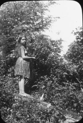
ca. 1912. Portrait of Bahlkabuh, Skokomish "Puget Sound Type" Photograph by Edward Curtis. Scanned from Asahel Curtis lantern slide. Original photo appears in The North American Indian, v.9 Plate between pp. 26-27 (slide has crack through coverglass). The Skokomish were one band of a tribe that called itself the Twana. They controlled the entire Hood Canal area and that of its tributaries. The Skokomish were located at Annas Bay and the watershed of the Skokomish River. The other principal bands were the Tulalip, Soatlkobsh, Quilcene, and Slchoksbish. At the early part of the 19th century, they numbered 900. By the Treaty of Point No Point, 1855, that confined them to the Skokomish Reservation at the head of Hoods Canal, they totalled 300.
Indians of North America--Skokomish--1910-1920; Women--Indians of North America; Indians of North America--Portraits;
Part of Edward S. Curtis Collection
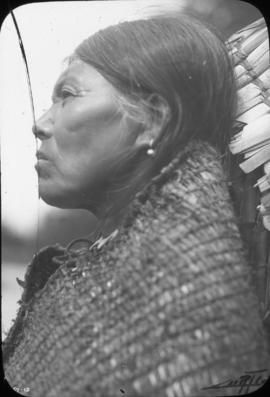
ca. 1912. A Primitive Quinault woman. Photograph by Edward S. Curtis. Scanned from Asahel Curtis lantern slide. Original print appears in The North American Indian, v.9 Plate # 293. The territory of the Quinaults extends along the coast from the Hoqium River to the Queets river. The tribe was less migratory than most of the north Pacific coast. They travelled to hunt and gather no further than a day or two from their home, although they did participate in limited whaling. They lived primarily off the abundant fish in their local rivers.
Indians of North America--Quinault--1910-1920; Women--Indians of North America;
Part of General Photograph Collection
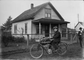
ca. 1912. This unidentified boy is seated on a Flanders 4 motorcycle parked outside on grass while a man, several feet away, looks on in this circa 1912 photograph. The Flanders 4 was built for "all-round serious service, day in and day out, and especially on rough roads." The motorcycle was not meant for kids nor for speedsters but for those desiring a safe and dependable ride. The Flanders Mfg. Co. of Pontiac, Michigan, sold this model "4" motorcycle to RFD carriers who were certain to encounter errant road conditions or bad weather while on their carrier routes. The price was $175 at the factory and it was guaranteed unequivocally. (scanned from negative, no print on file) GDOE-168 (www.postalmuseum.si.edu/rfdmarketing) TPL-10532
Motorcycles; Houses--1910-1920;

Part of Richards Studio Photographs
ca. 1912. The name painted on the side of the brewery is the Columbia Brewing Company. The building was built in 1900 when the brewery was established. Like most early breweries this building was tall and took advantage of gravity in moving materials through the brewing process. Grain storage and milling was often located high in a brewery on the 3rd or 4th floor. The copper brew kettle was commonly located beneath the mash tun at ground level. Copies of old prints ordered by Columbia Breweries in 1951. (Brewed in the Pacific Northwest, Gary and Gloria Meier)
Brewing industry--Tacoma--1910-1920; Columbia Brewing Co. (Tacoma);
Part of Edward S. Curtis Collection
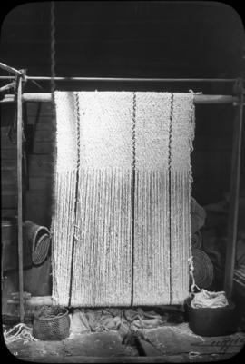
Image title: Coathair blanket - Cowichan. The North American Indian, v. 9, p. 72.
Indians of North America--Salishan--1910-1920; Weaving--Indians of North America;
Part of Edward S. Curtis Collection
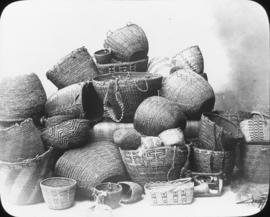
ca. 1912. Puget Sound Baskets Photograph by Edward S. Curtis. Scanned from Asahel Curtis lantern slide. Original print appears in The North American Indian, v.9 Plate # 309. Basketry was a prominent industry of the native women. A water-tight basket was made for hauling water, cooking with hot stones and berry picking. This type of basket was tightly coiled. A more flexible, softer woven basket was used for storing and carrying personal effects. A much larger basket of a rougher weave was used as a burden basket. It was carried on the back and used primarily for transporting clams and fish.
Indians of North America--Baskets;
Part of Edward S. Curtis Collection
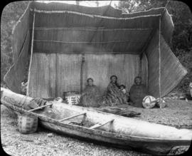
ca. 1912. Puget Sound Camp - Skokomish. Photograph by Edward S. Curtis. Scanned from Asahel Curtis lantern slide. Original photograph published in "The North American Indian, v.9" Plate between pp. 48-49. TPL-8759
Indians of North America--Skokomish--1910-1920; Indians of North America--Shelters; Canoes;
Part of Edward S. Curtis Collection
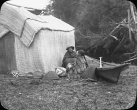
ca. 1912. A mat shelter - Skokomish. Photograph by Edward S. Curtis. Scanned from Asahel Curtis lantern slide. Original photograph published in "The North American Indian, v.9" Plate appears between pp. 110 -111. The aboriginal name for the people occupying the region of Hood Canal on the Olympic Peninsula was the Twana. The largest community in this tribe was the Skokomish, the "Big River People." The Skokomish Reservation was created by the Point-No-Point treaty in 1855 and it encompasses almost 5,000 acres on the delta of the Skokomish River. During the winter months, the people resided in cedar plank houses. But during the other seasons, they resided in temporary, movable structures such as the one pictured, which they covered with woven mats. These structures could be moved from place to place during hunting and fishing seasons. The mats, hung on the framework of the structure, would keep out the wind and the rain. The mats were most commonly woven of cattail leaves or the inner bark of the cedar. Two women are picture outside of a structure, along with their canoe and woven baskets.
Indians of North America--Skokomish--1910-1920; Women--Indians of North America; Huts; Indians of North America--Shelters; Canoes; Baskets;
Tahoma: The Mountain of the Gods
Part of Local Writings and Publications
Part of General Photograph Collection
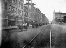
Pacific Avenue appears rather empty on the morning of May 19, 1912, except for the parishioners of St. Joseph's Slovak Catholic Church who were celebrating the dedication of their new church with a parade in downtown Tacoma. Two small girls are pictured in the foreground in a small buggy pulled by one horse as they pass the McCormack Bros. store. The new church, the first Slovak Catholic church built in the Northwest, was located at South 34th and Tacoma Avenue South. It was dedicated at 10 o'clock a.m. with Bishop Edward J. O'Dea conducting the service. Church members provided the labor necessary to build the 92 x 46-feet brick veneer building. The church and building site was paid for entirely by Slavonians, the congregation and/or other Slavonians in the community. (TDL 5-19-12, p. 33-article)
Parades & processions--Tacoma--1910-1920; Commercial streets--Tacoma--1910-1920; St. Joseph's Slovak Catholic Church (Tacoma); Church dedications--Tacoma;
Part of General Photograph Collection
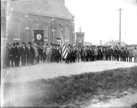
Members of the Polish National Alliance posed at the dedication of St. Joseph's Church, 602 South 34th St., on May 19, 1912. The men all wear ribbons/medals. It is not known whether the large group participated in the parade down Pacific Avenue prior to the church dedication.
St. Joseph's Slovak Catholic Church (Tacoma); Catholic churches--Tacoma--1910-1920; Fraternal organizations--Tacoma--1910-1920; Polish National Alliance (Tacoma);
Part of General Photograph Collection
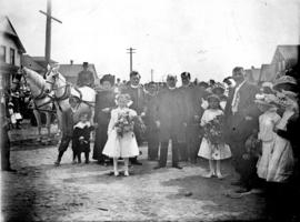
Bishop Edward J. O'Dea at dedication of St. Joseph's Catholic Church, 602 South 34th Street, on May 19, 1912. He was assisted by Rev. Father Paul Kern and Rev. Aloysius Mlinar, rector. Some of the 150 members appeared in this photograph with two young girls carrying large bouquets. St. Joseph's was the first Slovak Catholic church built in the Northwest. The building and ground were paid for entirely by Slavonian church members or those in the Slovak community. The church was built by its congregation who labored after finishing their regular jobs. It was estimated that this volunteer labor saved more than $10,000 in construction costs with the building costs initially set at $25,000. (TDL 5-19-12, p. 33-article)
St. Joseph's Slovak Catholic Church (Tacoma); Catholic churches--Tacoma--1910-1912; Church dedications--Tacoma;
Part of General Photograph Collection
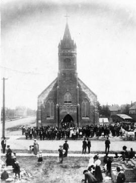
Parishioners celebrated the dedication of the St. Joseph Slovak Catholic Church on May 19, 1912. The church, located at 602 South 34th St., was built by congregation members who had purchased the site in April of 1908. Piles of bricks remained in the photograph's foreground across the street from the church. The structure stood 92 x 46-feet tall with a full concrete basement. The auditorium was 46 x 73-feet and seated 450 people. Membership was approximately 150. St. Joseph's was the first Slovak Catholic church built in the Northwest. (TDL 5-19-12, p. 33-article)
St. Joseph's Slovak Catholic Church (Tacoma); Catholic churches--Tacoma--1910-1920; Church dedications--Tacoma;