Print preview Close

Showing 21 results

Collections
General Photograph Collection Aerial Photography With digital objects
Print preview View:

TPL-835

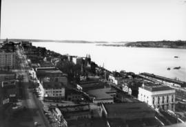
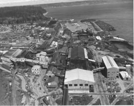
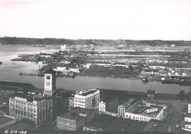
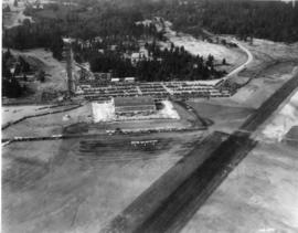
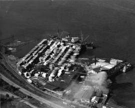
ca. 1938. Dickman Lumber, 2423 Ruston Way. This aerial view, taken circa 1938, shows vast stacks of lumber ready to be loaded onto ships. Dickman Lumber was located just south of the present Old Town dock. It was purchased in 1922 by Leonard Howarth and Ralph L. Dickman, Sr. Dickman Lumber was closed in September of 1977 and its mill destroyed by fire in January of 1979.


Aerial photographs; Dickman Lumber Co. (Tacoma); Lumber industry--Tacoma--1930-1940; Shipping--Tacoma--1930-1940;

G9.1-085

ca. 1958. Aerial view of No. 30th Street and Ruston Way. The largest street running vertically in the photograph is No. 30th Street. The street running along side of the water is Ruston Way. Just below the bottom of the picture is the intersection with Starr Street. The next street (that crosses the railroad tracks) is McCarver. The businesses running along Ruston Way (from the bottom up) are the Ocean Fish Mart, the Top of the Ocean nightclub, a small office building, Tacoma Boat Mart and the Dickman Lumber Mill (the largest group of buildings.) TPL-8657


Aerial photographs--Tacoma--1950-1960; Ocean Fish Mart (Tacoma); Top of the Ocean (Tacoma); Dickman Lumber Mill (Tacoma);

G9.1-112

ca. 1961. Aerial looking south by Oswald Flying Service of the neighborhoods including the Lincoln district circa 1961. Lincoln High School (701 So. 37th) and Lincoln Bowl are near the top right adjacent to So. "G" St. Cartozian & Sons Rug Co., in the large old Bye Thompson Motors building at 3320 So. "G," is further north. The massive stand of trees is part of Lincoln Park. The street to the left of "G" is Tacoma Avenue. The big building in the upper center on Tacoma Avenue is the St. Joseph Catholic Church, at the corner of So. 34th & Tacoma Ave. Holy Rosary Catholic Church, school and rectory (in the 500 block of So. 30th) are near the bottom center of the photograph. Delin St. is at the very bottom of the picture. At the upper left corner of the photograph is Pacific Avenue. Mountain View General Hospital (later renamed Puget Sound General Hospital in 1969) is at 3572 Pacific Ave., the large set of buildings near the upper left corner. G9.1-112


Aerial photographs; Neighborhoods--Tacoma--1960-1970; Streets--Tacoma--1960-1970; Holy Rosary Church (Tacoma); Lincoln High School (Tacoma); Lincoln Bowl (Tacoma); Cartozian & Sons Rug Co. (Tacoma); St. Joseph's Catholic Church (Tacoma);

TPL-1058

Lake Steilacoom - from the north end looking south. This undated aerial view of Lake Steilacoom was taken by the Barnes Aviation Co. A bridge is visible on the upper right connecting Interlaaken Dr. S.W. to Bridge Road on the west side of the lake. The road on the lower right corner is probably Lake Steilacoom Dr.


Aerial views; Aerial photographs; Lake Steilacoom (Wash.);

TPL-6997

View looking north on Saint Helens St. from the top of the Medical Arts Building on April 5, 1931. Buildings that are clearly visible include the Webster Apartments (629 Saint Helens) and the Elks Temple (565 Broadway- large white building lower right), followed by (right to left) an apartment building (553 Broadway) and the Union Club (539 Broadway.)


Aerial photographs--1930-1940; Cityscapes--1930-1940; Webster Apartments (Tacoma); Elks Temple (Tacoma); Union Club (Tacoma); Commercial streets--Tacoma--1930-1940;

G9.1-084

ca. 1948. Aerial view of ASARCO. Lying just beyond the smelter is the Tacoma Yacht Club, followed by the ferry dock. The residential area to the left top is Ruston and the wooded area beyond is Point Defiance Park. TPL-8656


Boathouses; Boats; Tacoma Yacht Club (Tacoma); Mooring; American Smelting & Refining Co. (Tacoma); Smelters--Tacoma--1950-1960; Point Defiance Park (Tacoma);

G9.1-136

ca. 1970. This is how South 38th St. looking west appeared circa 1970. Yakima Ave. is at the bottom of the photograph. Identified businesses (from left) on Yakima are the Brad Bannon Insurance Co. (3808 Yakima) and the Oroweat Bakers (3802 Yakima). The Arctic Circle Drive-In is nearby at 820 So. 38th St. Also facing 38th St. is the Hartman Furniture store at 803 So. 38th (across the street from Oroweat). On the same side of So. 38th St. as Hartman's but further west is Failor's Pharmacy. The area has had a thriving business district for several decades.


Streets--Tacoma--1970-1980; Neighborhoods--Tacoma--1970-1980; Brad Bannon Insurance Co. (Tacoma); Oroweat Bakers (Tacoma); Arctic Circle Drive-In (Tacoma); Hartman Furniture (Tacoma); Business districts--Tacoma--1970-1980;

TPL-3140

ca. 1968. Interstate 5 was not yet five years old in 1968 when the Tacoma City Photographer shot this aerial view of the South 56th Street cloverleaf. The area has seen major growth in just over thirty years. Tacoma Mall Boulevard, formerly South Ferry Street, runs parallel to the freeway at the right. The undeveloped land at center is the area known as Wapato Hills.


Aerial photographs; Express highways--Tacoma--1960-1970; Interstate 5--Washington (State); Neighborhoods--Tacoma--1960-1970;

TPL-4063

ca. 1920. Aerial view of Lakewood area, looking northwest, was taken by Barnes Aviation Co. in 1920. The building at right center is Lakeview School. The road at bottom of image is Pacific Highway with Northern Pacific Railroad tracks running next to the road. The street at left blending into Pacific is Lakeview Blvd. There are a few stores congregated near the bottom of the photograph.


Aerial photographs; Aerial views; Lakeview School (Lakewood); Streets--Lakewood; Railroad tracks--Lakewood;

TPL-4091

ca. 1920. Aerial view of Lakewood area, looking north, as photographed in 1920 by Barnes Aviation Co. The building at top center is Lakeview School. Road running along right top of image is Pacific Highway with Northern Pacific Railroad tracks next to road. Road going right to left across bottom is Old Highway 99 Road cutting across center of image and disappearing into the trees is the old Boundary Road (now 112th Street SW).


Aerial photographs; Aerial views; Lakeview School (Lakewood); Streets--Lakewood; Railroad tracks--Lakewood;

TPL-4063B

ca. 1920. Aerial view of the north side of Lakeview (now Lakewood) area, looking east, as photographed by Barnes Aviation in 1920. Building at left edge near center is Lakeview School. The road running left to right though the image is Pacific Highway with Northern Pacific Railroad tracks next to the road. This part of Lakewood was not highly developed at the time.


Aerial photographs; Aerial views; Lakeview School (Tacoma); Streets--Lakewood; Railroad tracks--Lakewood;

TPL-4064

ca. 1920. Unidentified farm on unidentified lake probably in the Lakewood/Spanaway region of Pierce County. Aerial photograph was taken circa 1920 by the Barnes Aviation Co.


Aerial photographs; Farms--1920-1930; Lakes & ponds--Washington;

TPL-4085

North side of American Lake. This area view was taken by Barnes Aviation Co. in the spring of 1920. The large building on the waters edge at the bottom of the photo is the American Lake Boathouse. Hiding in the trees just above the Boathouse is the American Lake Inn. Both buildings have since been demolished. The boathouse, called Martin's American Lake Boathouse, was destroyed in a supervised burn by the Lakewood Fire Department in June of 1955. The boathouse had been built around the turn of the 20th century and served the community for many years as a recreational center for boating and fishing and as the site for dances and social functions. It gradually deteriorated and plans were made to replace it with a modern structure. The American Lake Inn was also built in the first decade of the 20th century. By May of 1904, the 20-room resort was open for business. It was owned by Mrs. H.I. Nolan. Included was a handsome pavilion for exclusive use of the Inn's guests. (TNT 6-19-1955- article on boathouse burn; TDL 5-29-04, p. 7-article on American Lake Inn)


American Lake (Wash.); Aerial photographs; Aerial views; American Lake Boathouse (Lakewood); American Lake Inn (Lakewood);

TPL-6998

View of Tacoma Tideflats from the top of the Medical Arts Building. The City Waterway can be seen in the background. City Hall, with its distinctive clock tower, is clearly visible. This photograph was taken on April 5, 1931.


Aerial photographs--1930-1940; Cityscapes--1930-1940; City Waterway (Tacoma); Old City Hall (Tacoma);

TPL-6999

View of downtown business district of Tacoma looking southeast from the top of the Medical Arts Building as seen on April 5, 1931. Good view of the fronts of the buildings on the east side of Broadway between 9th and 11th.


Aerial photographs--1930-1940; Business districts--Tacoma--1930-1940;

G8.1-009

ca. 1894. Business district of Tacoma (copy of original), circa 1894. Many of the streets surrounding Pacific Avenue in the 1890s, even then the heart of the city's financial district, were filled with a hodgepodge of wood framed buildings and more substantial brick structures. At the foreground are the Pioneer Paint Store, sellers of wallpaper, mouldings, paints, and glass and W.H. Robison's, where new and second hand goods could be purchased. The Freeman & Boggs livery stable, near left center, stood near the corner of 13th & Pacific. George A. Boggs, who was City Treasurer before going into private business, had been sent away to the state pen in Walla Walla after auditors found a $109,000 shortage in the city books. Also in the far right background is the steeple of the original St. Leo's Church near So. 11th & "D" St. S7.2, TPL-378 (Researched by Murray Morgan)


Commercial streets--Tacoma--1890-1900; Business districts--Tacoma--1890-1900; Freeman & Boggs Livery (Tacoma); Pioneer Paint Store (Tacoma); W.H. Robison (Tacoma);

G8.1-070

ca. 1960. Aerial view of Tideflats and downtown Tacoma area, including Wright Park and slices of Division Avenue, ca. 1960. Mount Rainier looms in the background, overlooking the industrial area of Tacoma, City (now Thea Foss) Waterway with its boats and log dumps, and the 11th St. Bridge. Familiar buildings such as the Puget Sound National Bank, Rust, and Washington buildings can be spotted on Pacific Avenue. The County-City Building with its two wings and the State Armory are in mid-photo. The wooded area is Wright Park with its meandering paths clearly marked. Adjoining the park at 9th & Division is the Greek Ionic styled First Church of Christ, Scientist. TPL-9664


Aerial photographs; Neighborhoods--Tacoma; Wright Park (Tacoma); Rainier, Mount (Wash.);

TPL-010

ca. 1939. Artistically modified aerial view of West Tacoma and the Tacoma Narrows. The bridge and the ship under it in the photo were painted in. The bridge was not yet complete in 1939. It would open for traffic on July 1, 1940 and go down in dramatic fashion on November 7, 1940.


Aerial views; Aerial photographs; Neighborhoods--Tacoma--1930-1940; Tacoma Narrows Bridge (Tacoma);