Aerial Photography

Taxonomy

Code

Scope note(s)

Source note(s)

Display note(s)

Hierarchical terms

Aerial Photography

Equivalent terms

Aerial Photography

Associated terms

Aerial Photography

824 Collections results for Aerial Photography

824 results directly related Exclude narrower terms

D152770-1C

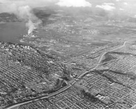
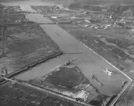
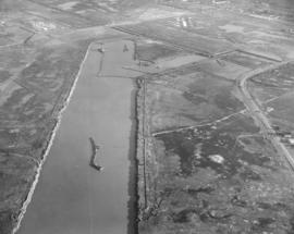
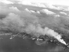
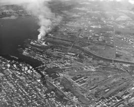
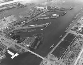
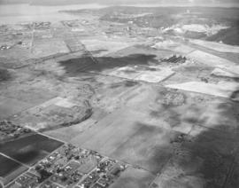
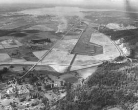
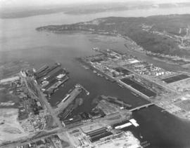
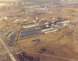
Color aerial of Tacoma Tideflats, featuring Reichhold Chemicals at 2340 Taylor Way. Reichhold's taupe-colored buildings blend in with the acres of dirt in this November, 1967, photograph. Reichhold manufactured chemicals for various Pacific Northwest industries including the stalwart plywood field. The company had initially established its plant on 51 acres on nearby Lincoln Ave in 1956 but had moved to the Taylor Way location by 1963. Hylebos Waterway is toward top of photograph along with PennSalt facilities. Photograph ordered by Reichhold Chemicals, Inc.


Aerial photographs; Reichhold Chemicals, Inc. (Tacoma); Hylebos Waterway (Tacoma);

C152548-2

ca. 1967. Copy of customer's print. Closer view of aerial with names of various freeways and major roadways, present and projected, ca. 1967. There had long been talk about building a multi-purpose stadium in the Puget Sound region. This map shows the proximity of such a stadium to major freeways and the Seattle-Tacoma Airport. Even rapid transit was a future prospect to bring visitors and patrons to this area. The Pierce County Sports Stadium Advisory Committee had proposed a 120-acre site at the intersection of So. 277th & West Valley Highway in King County. A group of Tacoma citizens had an option on the land. Pierce County residents were to vote on a $10 million bond issue to help King County build a stadium if a site was chosen south of the airport. Photograph ordered on October 30, 1967, by Bozell & Jacobs Advertising. (TNT 10-31-67, p. 1)


Aerial photographs; Express highways--Wash.;

C152548-1

ca. 1967. Copy of aerial print of Puget Sound region featuring major and projected freeways, ca. 1967. Seattle-Tacoma Airport's proximity to an anticipated Multi-Purpose Stadium is noted. Freeways are labeled and locations accentuated by white lines. Pierce County residents would be asked to support a $10 million bond that would assist King County in building a sports stadium should a site be chosen south of the airport. Photograph ordered by advertising agency Bozell & Jacobs on October 30, 1967. (TNT 10-31-67, p. 1)


Aerial photographs; Express highways--Wash.;

D144001-297A

Stock footage. Another view by air of downtown Tacoma, City (now Thea Foss) Waterway, and industrial Tideflats area. Tacoma's major business area was still in downtown Tacoma although some major retail stores, like the Bon Marche and soon, J.C. Penney's, had moved out to reach a more suburban clientele. The Tacoma Building on A St. still retained Weyerhaeuser's corporate offices and the Medical Arts Building on Market/St. Helens had not yet become the Tacoma Municipal Building. Major landmarks clearly visible are the County-City Building and Tacoma Public Library on Tacoma Ave. So., Medical Arts Building on St. Helens, Tacoma Building and Perkins Building on A St., 11th Street Bridge, Washington and Rust Buildings and Puget Sound National Bank on Pacific Ave. TPL-10059


Aerial photographs; Commercial streets--Tacoma--1960-1970; Tacoma Building (Tacoma); Medical Arts Building (Tacoma); County-City Building (Tacoma); Tacoma Public Library (Tacoma); Perkins Building (Tacoma); Washington Building (Tacoma);

D144001-296

Another in the series of Richards Stock File 1965 aerial photographs of the downtown Tacoma area looking toward the 11th St. Bridge and the Tideflats industrial area. The State Armory, Tacoma Vocational-Technical Institute and St. Leo's School are on one of the major thoroughfares, Yakima Ave. The next major street is below Yakima Ave.; Tacoma Ave. So. holds the County-City Building with its two wings, and Tacoma Public Library. Closer to the City (now Thea Foss) Waterway are major banks, Puget Sound National Bank and Bank of California, found on Pacific Ave. The Rust, Washington, Tacoma and Perkins Buildings are in close proximity. TPL-501


Aerial photographs; Commercial streets--Tacoma--1960-1970; State Armory (Tacoma); St. Leo's Parochial School (Tacoma); County-City Building (Tacoma); Tacoma Public Library (Tacoma); Puget Sound National Bank (Tacoma); Rust Building (Tacoma);

D144001-297

Stock Richards file. Aerial photograph of downtown Tacoma area, looking in northeasterly direction towards the Tideflats, taken on June 5, 1965. Smoke from St. Regis billows across the bustling industrial Tideflats on an otherwise clear summer day. Major landmarks on the city side near the City (now Thea Foss) Waterway are clearly discernable, including the Tacoma Building, Puget Sound National Bank and its distinct spire, and the 11th St. Bridge. Further west are the County-City Building with its two wings, Tacoma Public Library, State Armory, Tacoma Vocational-Technical Institute, and St. Leo's School.


Aerial photographs; Commercial streets--Tacoma--1960-1970; Tacoma Building (Tacoma); Puget Sound National Bank (Tacoma); City Waterway (Tacoma); 11th Street Bridge (Tacoma); County-City Building (Tacoma); Tacoma Public Library (Tacoma);

D145092-3

The new Elks Temple under construction at 1965 So. Union Ave. in June, 1965. The 1.5 million dollar structure is located on the west side of Cedar St., 700 feet south of So. 19th. Ground was broken on April 25, 1964, for the project; seventeen months later in September, 1965, the temple would be dedicated. Eastwardly view of Elks Temple in left lower corner, Allenmore Golf Course, and freeway in the distance.


Aerial photographs; Benevolent and Protective Order of Elks, Tacoma Lodge No. 174 (Tacoma);

D145080-2

This aerial view of the new colonial style Lakewood Motor Inn at 6125 Motor Avenue S.W. in Lakewood shows the motel as it looked on June 5, 1965, the 41-unit, deluxe inn's opening day. Located at the corner of Motor Avenue S.W. and Whitman, across from the Lakewood theater, the L-shaped, two-story complex was designed by Donald F. Burr & Associates. It featured a large courtyard with an outdoor swimming pool. Although the area around it has greatly changed, the motel is still there - now called the Best Western Lakewood Motor Inn. (Photograph ordered by Business Industry Development Service. ) (TNT 6-4-65, p. 18, TNT 6-11-65, p. 8,9)


Aerial photographs; Lakewood Motor Inn (Lakewood); Motels--Lakewood--1960-1970; Swimming pools--Lakewood;

D145092-4

View by air of the new Tacoma Elks Temple being constructed in the 1900 block of So. Union Ave. in June of 1965. The building was designed by the architectural firm of E.L. Mills & Associates and built by Strom Construction Co. using reinforced concrete and structural steel. Tacoma Lodge No. 174, one of the largest Elks Club memberships in the world, had voted to build a new temple away from its 50-year location on Broadway. The 1.5 million dollar (later cost revised to 2 million dollars) temple would be dedicated on September 3, 1965, amidst celebrating the lodge's upcoming 75th anniversary.


Aerial photographs; Benevolent and Protective Order of Elks, Tacoma Lodge No. 174 (Tacoma); Building construction--Tacoma--1960-1970;

D147400-19

ca. 1966. 1966 Richards Studios stock footage. Homes and businesses resemble tiny matchbox buildings when viewed by air in 1966. The newly completed I-5 freeway snakes its way northbound flanked by the populous Eastside and downtown Tacoma regions. Tacoma industrial area to the photograph's left center; smoke billows from St. Regis Paper Co.'s plant, a familiar sight for over 30 years.


Aerial photographs; Express highways--Tacoma--1960-1970; Cityscapes;

D147400-100

1966 Richards stock footage. Aerial general view is southwest looking to the northeast. I-5/512 interchange in middle of photo. McChord Field is in lower right with planes on tarmac. Southgate neighborhood is on the left side of I-5. Large building in lower center is believed to be the Gov-Mart discount department store. Port of Tacoma is in the distance; South and East Tacoma neighborhoods compose remainder of photo. TPL-10361


Aerial photographs; McChord Field (Tacoma); Express highways--Lakewood;

D147400-18

ca. 1966. 1966 Richards stock footage. Work continues on the expansion of the Port Industrial Waterway in 1966 as men and equipment are used to extend the waterway to Lincoln Ave., a major roadway in the Tacoma industrial Tideflats area. Water now covers the land area past the Lincoln Ave. railroad bridge due to dredging. The earth is being moved to make way for ocean-going ships. The Port of Tacoma saw major growth in 1965; 96 more ships loaded and unloaded cargo at the Port docks during the first nine months of 1965 than the same time in 1964. (TNT 10-31-65, B-10; TNT 11-14-65, A-15)


Aerial photographs; Port Industrial Waterway (Tacoma);

D147400-21

1966 Richards stock footage. View from air on February 1, 1966, shows the new extension of the Port Industrial Waterway in the Tacoma Tideflats. The new cut would extend to Lincoln Ave. Working around-the-clock are General Construction Co. dredges to move the 6000-feet waterway inland. The earth was moved to make way for ocean-going ships. The project is expected to be completed in October, 1966. (TNT 10-31-65, B-10, TNT 11-14-65, A-15)


Aerial photographs; Port Industrial Waterway (Tacoma);

D147400-103

This aerial view of the Tacoma Industrial Airport (now the Tacoma Narrows Airport) on Point Fosdick, looking in a northerly direction, was taken in August of 1966, Gig Harbor is located beyond the right corner. On August 13th the airport sponsored a free air fair featuring: the Goodyear "Blimp", the Columbia; demonstrations of the TideAir "Hello Super Courier", which could take off and land within 100 feet; and a flyby by the new 141 "Starlifter" jet transport. According to an advertisement taken out by the airport and published in the News Tribune, air traffic had been increasing every month at the airport. In 1965, a total of 35,728 take-offs and landings were recorded by airline, military, and general aviation aircraft. (TNT ad, 8/12/1966 p. 12)


Aerial photographs; Tacoma Industrial Airport (Wash.); Airports;

D147400-24

1966 Richards stock footage. Mount Rainier, with Mount Adams in the background to the right, looms over the Lake Tapps/South Auburn general area in 1966. The aerial view is northwest to southeast, taken from about the I-5/Highway 18 intersection. Lake Tapps is large body of water in mid-photo. Nearby is the White/Stuck River at the foot of the hills lined with trees. The southern portion of the city of Auburn is on the left side of the photograph. The large complex of warehouse-styled buildings in the foreground is a Boeing plant.


Aerial photographs; Lake Tapps (Wash.); Rainier, Mount (Wash.);

D147400-15

1966 Richards stock footage. Northbound look by air of the Tacoma Tideflats industrial area, home to St. Regis Paper Co. and many others, on April 5, 1966. Heavy smoke identifies the location of St. Regis towards the left side of photo, next to the Puyallup Waterway. Among various nearby waterways is the Port Industrial Waterway (center) which was being extended. Interstate 5 is freeway running left to right near the bottom of the photograph. At the end of 1965 the freeway ran from the Oregon border through Tacoma to Midway.


Aerial photographs; St. Regis Paper Co. (Tacoma)--1960-1970; Smoke--Tacoma; Port Industrial Waterway (Tacoma); Express highways--Tacoma--1960-1970;

D147400-17

Richards Studios stock footage, 1966. Looking south via air, smoke from St. Regis Paper Co.'s plant and low clouds obscure the Tacoma Tideflats landscape on April 5, 1966. A small section of the Puyallup River can be spotted on the extreme right; various waterways emerging into Commencement Bay include the Hylebos on the extreme left, Port Industrial and Sitcum.


Aerial photographs; St. Regis Paper Co. (Tacoma)--1960-1970; Smoke--Tacoma; Puyallup River (Wash.); Hylebos Waterway (Tacoma); Port Industrial Waterway (Tacoma); Sitcum Waterway (Tacoma);

D147400-10

This aerial view of Tacoma's business district and industrial tideflats was taken on April 5, 1966 - forty years ago. From high above the city some familiar landmarks, such as the 11th Street Bridge (now the Murray Morgan Bridge) and the channelized Puyallup River, are easy to pick out. Heavy smoke billows from the St. Regis Paper Company plant (now Simpson Tacoma Kraft) which is flanked by the Puyallup Waterway and the St. Paul Waterway. Missing are the new 509 cable-stay bridge spanning the Thea Foss Waterway and I-705.


Aerial photographs; City Waterway (Tacoma); 11th Street Bridge (Tacoma); St. Regis Paper Co. (Tacoma)--1960-1970;

C147307-1

ca. 1960. Copy of aerial view of Lakewood business district, including the Lakewood Center and Villa Plaza Shopping Center, ca. the early 1960's. The Lakewood Center, among the first of the nation's one-stop shopping centers, is at bottom center. It is bordered by Bridgeport Way (curving long road on left), Gravelly Lake Dr. and Mt. Tacoma Dr. Towards the center of the photograph is the massive Villa Plaza Shopping Center, built in 1957 on the site of the former 200-acre Visitation Villa. The Villa Plaza constantly promoted their 4000 car parking lot, which may have attracted many shoppers eagerly looking for the convenience of free, available parking. Photograph ordered by the Bank of Tacoma.


Aerial photographs; Shopping centers--Lakewood--1960-1970; Villa Plaza Shopping Center (Lakewood); Lakewood Community Center (Lakewood);

D138106-2

Overhead view of Georgia-Pacific Corp. quarters on Ross Way. A few cars are parked outside Georgia-Pacific on April 9, 1963. One large truck appears to be in the process of loading boxes. Georgia-Pacific, dealers in wholesale plywood, had built a plant in the industrial Tideflats area near Thorne Rd. and E. 11th St.


Aerial photographs; Georgia-Pacific Corp. (Tacoma);

D138106-3

Closer aerial view of loading dock belonging to Georgia-Pacific Corp. on the Tideflats. This April 9, 1963, photograph shows that convenient rail transportation made delivery and pickup of wood products an easier process for the dealer in wholesale plywood. Tracks run just a few feet away from the loading dock with a detached container standing by.


Aerial photographs; Georgia-Pacific Corp. (Tacoma); Railroad tracks--Tacoma--1960-1970; Railroad freight cars--Tacoma--1960-1970;

A138537-1

Aerial photograph taken in the spring of 1963 of portion of downtown Pacific Avenue; it features the Bank of California sign recently installed on top of the Washington Building. The Bank of California is the much smaller building adjacent to the Washington Building. It had been situated on Pacific Avenue since 1928. Bank officials confirmed that a move would be made in early 2005 into the historic Waddell Building at 15th & Commerce.


Aerial photographs; Signs (Notices); Bank of California National Association (Tacoma); Washington Building (Tacoma); Commercial streets--Tacoma--1960-1970;

D139204-3

Aerial view of the Port Industrial waterway taken in late August, 1963, with industrial facilities close by. 11th St. runs horizontally over the waterway. Bridge is the Blair Bridge. Photograph ordered by Port of Tacoma. TPL-2248


Aerial photographs; Port Industrial Waterway (Tacoma);

D139204-6

Closer view of Tacoma Tideflats area in late August, 1963, focusing on the Port Industrial Waterway and Blair Bridge. The waterway is wide enough for log booms to share space with docked ships and boathouses. At the top of the photograph, a small segment of the Puyallup River can be seen. Next are the Milwaukee and Sitcum Waterways. Photograph ordered by Port of Tacoma. TPL-10519


Aerial photographs; Logs; Port Industrial Waterway (Tacoma); Milwaukee Waterway (Tacoma); Sitcum Waterway (Tacoma);

D139403-1

Aerial view taken on September 18, 1963, of the City of Fircrest and vicinity. Surrounded by trees, Fircrest is pictured toward the center of the photograph. Pearl Street runs through Fircrest all the way to Point Defiance. Orchard Street runs parallel to Pearl to its right. Narrows Bridge is at the top. Ruston with the ASARCO smelter is at top right corner with forested Point Defiance to its left. A similar aerial view, taken on the same day, is at D137300-529. Photograph ordered by Puget Sound National Bank who may have asked that white dots be drawn on the photograph defining the approximate Fircrest boundaries. Puget Sound National Bank would open a new branch building in Fircrest two years later on November 6, 1965, at the Fircrest Village Square Shopping Center. Fircrest at the time had a population of 4,588.


Aerial photographs; Neighborhoods--Fircrest; Tacoma Narrows Bridge (Tacoma);

D139204-1

Browns Point is the extension of land near the top of this late August, 1963, photograph. Aerial views of Tacoma's industrial areas also show 11th St. running horizontal with Lincoln Ave. below. The Hylebos Waterway is the most easterly of Tacoma's waterways; gravel pit to its right. Buildings with dark roofs are believed to be part of the Educators Mfg. plant. Photograph ordered by Port of Tacoma.


Aerial photographs; Hylebos Waterway (Tacoma);

D139204-18

Aerial view of Tacoma Tideflats focusing on area close to the Hylebos Waterway. In this late August, 1963, photograph, the waterway appears clogged with silt. The narrow strip that leads into the Hylebos is Hylebos Creek. Gravel pit to the far right; large dark-roofed building in left center is possibly Educators Mfg. Long vertical road is Taylor Ave.; Marine View Drive is believed to be semi-circular road. Houses at the bottom of the photograph are believed to be in Fife neighborhoods. Photograph ordered by Port of Tacoma.


Aerial photographs; Hylebos Waterway (Tacoma);

D139230-1

Aerial photograph of ships docked in Hylebos Waterway taken on August 24, 1963. Log booms float near docks. A small tug streams toward open waters. Photograph ordered by the Port of Tacoma.


Aerial photographs; Hylebos Waterway (Tacoma); Logs; Cargo ships--Tacoma;

D139204-13

Aerial views of the Tacoma Tideflats area were taken in late August, 1963. There is still room for expansion in areas close to the waterways which lead into Commencement Bay. The close proximity of roadways and rail would mean that Tacoma was not limited to transporting their industrial and wood products only by water. A small piece of Browns Point can be spotted to the far right; City of Tacoma businesses to the far left. Waterway is the Port Industrial with the Blair Bridge. Roadway extending width of photograph is Lincoln Ave. Photograph ordered by Port of Tacoma. TPL-2258


Aerial photographs; Port Industrial Waterway (Tacoma);

D139204-2

Water views of Tideflats area taken by air in late August, 1963. Easy access by water, rail and highways made transport of industrial and wood products convenient and efficient for the many companies doing business in the Tideflats area. Browns Point juts into the water in the above photograph. Thick stands of trees flank the Hylebos Waterway on one side. Next waterway is the Port Industrial with the Blair Bridge visible on 11th St. Photograph ordered by the Port of Tacoma. TPL-8725 TPL-10518


Aerial photographs; Port Industrial Waterway (Tacoma); Hylebos Waterway (Tacoma);

Results 301 to 330 of 824