Aerial Photography

Taxonomy

Code

Scope note(s)

Source note(s)

Display note(s)

Hierarchical terms

Aerial Photography

Equivalent terms

Aerial Photography

Associated terms

Aerial Photography

824 Collections results for Aerial Photography

824 results directly related Exclude narrower terms

D140600-235

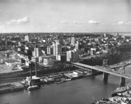
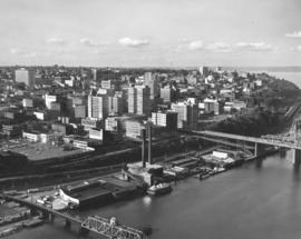
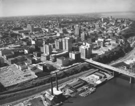
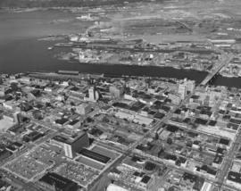
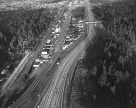
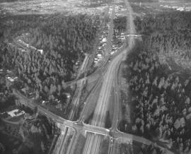
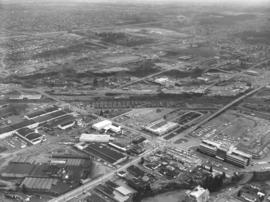
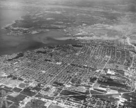
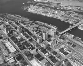
Stock footage; aerials of downtown Tacoma looking toward Tideflats, taken on June 23, 1964. At this height, the normally large looming buildings appear as small Monopoly structures. The 11th St. Bridge is pictured extending into the Tideflats. It is flanked near the City (now Thea Foss) Waterway by the Chicago-styled Tacoma Bldg. and Perkins Bldg. The Peoples Store, Washington and Rust Bldgs. are clearly visible. The towering building with steeple is the Puget Sound National Bank, at one time the tallest building on the West Coast. Toward the left center edge is the Medical Arts Building (now Municipal Bldg.), built in the Art Deco tradition, and the triangular-shaped Bostwick Block.


Aerial photographs; 11th Street Bridge (Tacoma); Bridges--Tacoma; Commercial streets--Tacoma--1960-1970; Tacoma Building (Tacoma); Perkins Building (Tacoma); Peoples (Tacoma); Washington Building (Tacoma); Rust Building (Tacoma);

D140189-8

Aerial southbound look at the Gov-Mart South building in the Ponders Corner area on December 10, 1963. It was sandwiched on land between I-5 and Hwy. 99, across from McChord Field. Many cars in parking lot with plenty of room for more. A full page ad in the News Tribune on March 18, 1964, proclaimed Gov-Mart to be the Northwest's first and finest membership department store. It was open to government employees, armed forces members, school district employees and labor union members. Gov-Mart was holding a special public-invited sale in March, 1964, to perhaps increase membership. Photograph ordered by Puget Sound National Bank. (TNT ad 3-18-64, B-1)


Aerial photographs; Gov-Mart South (Lakewood); Department stores--Lakewood--1960-1970;

D140600-428

Aerial of Tacoma city skyline. Stock footage, 1964. Only one car appears to be traveling across the 11th Street Bridge heading towards the industrial Tideflats area on this bright day in October, 1964. It has apparently passed through the Tacoma business district of Pacific Ave. and A Street. Prominent structures on these streets include the (Old) City Hall, Puget Sound National Bank, Rust Building, Washington Building, Tacoma Building and Perkins Building. Portions of Central School, County-City Building and the Tacoma Public Library can be spotted on Tacoma Ave. So., further in the background. TPL-2314


Aerial photographs; Commercial streets--Tacoma--1960-1970; 11th Street Bridge (Tacoma); Bridges--Tacoma;

D140600-429

Angled view of Tacoma city skyline taken on October 17, 1964, by air. Schuster Parkway has yet to be built through part of the wooded area shown. 11th Street Bridge leading to the Tideflats from the business district is first bridge towards right-center. ASARCO smelter in distance; glimpses of Stadium district including high school to the right top, (Old) City Hall on Commerce St. and its replacement, the County-City Building a few blocks away on Tacoma Ave. So., venerable Central School in upper center. City Waterway (now Thea Foss) is tranquil body of water shown. TPL-9654


Aerial photographs; Commercial streets--Tacoma--1960-1970; 11th Street Bridge (Tacoma); Bridges--Tacoma; City Waterway (Tacoma);

D140600-258

This was how the Cliff House Restaurant on Browns Point, center front, appeared from the air on June 23, 1964. Perched on a hillside overlooking Tacoma's waterfront, the Cliff House Restauant provided its customers with fine cuisine and scenic views. Originally built as a tavern in 1925, it was later remodeled and rebuilt after a massive fire in 1958. Houston "Hugh" O. Smith was still the owner in 1964.


Aerial photographs; Aerial views; Cliff House Restaurant (Tacoma); Restaurants--Tacoma--1960-1970; Neighborhoods--Tacoma--1960-1970;

D140600-25

Aerial photographs of So. 38th & Pine & freeway taken in February, 1964; stock footage. So. 38th St. cloverleaf upper left; I-5 runs across top portion of photograph. This focuses on the location of the upcoming Tacoma Mall Shopping Center. The Bon Marche, the first store built at the Mall, is the massive building standing alone in large otherwise vacant lot. The wooded area near the Bon would change soon as the Mall expanded; the National Bank of Washington and J.C.Penney had already announced plans to build in the Mall area and other stores would later join them. The circular building in the center is part of Madison School.


Aerial photographs; Bon Marche (Tacoma); Express highways--Tacoma--1960-1970; Shopping centers--Tacoma--1960-1970;

D140600-407

Stock footage, 1964. Aerial view of downtown Tacoma business district looking toward Point Defiance, taken on September 30, 1964. The ASARCO smelter can barely be seen in the distance. Closer focus is on portions of A St., Pacific Ave., and Tacoma Ave. So. with its multitude of tall buildings. Tacoma Building and Perkins Building flank the 11th Street Bridge which crosses the City (now Thea Foss) Waterway. Puget Sound National Bank, Washington Building, Rust Building, Peoples store, are closer to the waterway with the County-City Building, Tacoma Public Library and Central School on Tacoma Ave. So., several blocks away.


Aerial photographs; Commercial streets--Tacoma--1960-1970; 11th Street Bridge (Tacoma); City Waterway (Tacoma); Perkins Building (Tacoma); Tacoma Building (Tacoma); Washington Building (Tacoma); Rust Building (Tacoma); County-City Building (Tacoma);

D140600-236

1964 stock footage. Downtown business district and industrial Tideflats area are captured in this June 23, 1964, aerial photograph. 11th Street Bridge crosses the City (now Thea Foss) Waterway into the bustling Tideflats. Smoke can be seen rising from St. Regis Paper Co. whose operations ran 24 hours a day. Prominent structures in the downtown area included the Tacoma Bldg., Perkins Bldg., Puget Sound National Bank, Washington Bldg., Rust Bldg., Medical Arts Bldg., and further to the lower portion of the photograph, the County-City Building and Tacoma Public Library. State Armory is also located at bottom's edge.


Aerial photographs; Commercial streets--Tacoma--1960-1970; County-City Building (Tacoma); Tacoma Public Library (Tacoma); 11th Street Bridge (Tacoma); City Waterway (Tacoma); St. Regis Paper Co. (Tacoma)--1960-1970; State Armory (Tacoma);

D140600-40

This aerial view of the channelized Puyallup River as it flows through the Tacoma tideflats dates from February of 1964; the East 21st Street Bridge is at the bottom, center. Nearer to the mouth of the River, in the left corner, are the East 11th Street Bridge and the old Milwaukee Road railroad bridge. There is little development between East 11th Street and Lincoln Avenue. The buildings in the Port of Tacoma can be seen in the distance and Northeast Tacoma is on the horizon.


Aerial photographs; East 21st Street Bridge (Tacoma); Bridges--Tacoma;

D140189-5

Aerial view of Gov-Mart South building between Hwy. 99 and I-5 on December 10, 1963. Gov-Mart South was a discount department store. In the upper left can be spotted Clover Park Vocational School. In the upper right corner beyond the trees is the Southgate housing development. Photograph ordered by Puget Sound National Bank.


Aerial photographs; Gov-Mart South (Lakewood); Department stores--Lakewood--1960-1970; Express highways--Lakewood;

D140600-327

1964 stock footage. Aerials taken on July 24, 1964, looking toward Tacoma from over Sumner. Hylebos Waterway to extreme right. Other notable water features are the City (now Thea Foss) Waterway, meandering Puyallup River, and Port Industrial Waterway. Wooded Point Defiance near top of photograph. Fox Island left corner.


Aerial photographs; Hylebos Waterway (Tacoma); Puyallup River (Wash.);

D140419-1

Aerial photographs of the Lakewood area were taken on December 21, 1963, at the request of Puget Sound National Bank. This is reportedly the area between 84th and Ponders Station. Lakewood neighborhoods to the left would include Villa Plaza Shopping Center and Clover Park High School. The three large lakes are: Steilacoom, Gravelly and American Lake; Tacoma Country & Golf Club is on the shores of American Lake. McChord AFB to the right of I-5. TPL-9304


Aerial photographs; Neighborhoods--Lakewood--1960-1970; American Lake (Wash.); Lake Steilacoom (Wash.); Gravelly Lake (Wash.);

D140600-30

Aerial stock footage, February, 1964, of area near the upcoming Tacoma Mall. King's Hilltop Drive-In, upper right, is on So. 38th St. close to I-5. Eventually the large wooded area would become filled with businesses and parking lots associated with the Mall.


Aerial photographs; Shopping centers--Tacoma--1960-1970;

D140189-1

Aerial photographs looking northeast taken on December 10, 1963, on behalf of Puget Sound National Bank. The above photograph features Hwy 99 /I-5 at Ponders Corner. Nyanza Park is in the heavily forested area on the left, and Porter Woods is the forested area to the right.


Aerial photographs; Neighborhoods--Lakewood--1960-1970; Express highways--Lakewood;

D140189-13

December 10, 1963, aerial view looking northeast of I-5/Gravelly Lake Dr. interchange at Ponders. This has been identified as the Nyanza Park neighborhood of Lakewood. Woods to the left of highways are the Nelson Woods; Hillcrest St. is visible within woods. Water tower is found nearby surrounded by trees. McChord Field is on the upper right; Tacoma Country & Golf Club on lower left corner. Photograph ordered by Puget Sound National Bank.


Aerial photographs; Neighborhoods--Lakewood--1960-1970; Express highways--Lakewood;

D140419-3

This aerial view of the Lakewood area and I-5 dates from December, 1963. Gravelly Lake is to the left of I-5; the southern tip of Steilacoom Lake is on the left edge of the image. As you travel northeast on I-5, by moving up the image, the Lakewood Mall can be found to the left and McChord AFB to the right. Near the top left corner a plume of smoke floats above the St. Regis Paper Co. mill on the Tacoma tideflats. (Photograph ordered by Puget Sound National Bank.)


Aerial photographs; Neighborhoods--Lakewood--1960-1970; Lake Steilacoom (Wash.); Gravelly Lake (Wash.); American Lake (Wash.); Express highways--Lakewood;

D140600-35

Richards stock footage, February, 1964. Aerial view of city's south side, including Tacoma Mall at upper center with the Bon Marche standing alone; the 2.6 million dollar Tacoma Public Utilities Center on So. 35th St. is large structure toward the right corner of photograph. Union Ave. runs parallel to the public utilities building; City Water plant/shop is believed to be on Union across from Public Utilities Center.


Aerial photographs; Tacoma Dept. of Public Utilities, Light Division (Tacoma); Shopping centers--Tacoma--1960-1970;

D140600-241

Stock footage taken on June 23, 1964, of So. 19th & Union Ave. and vicinity. The H-shaped Unionaire Apartments was just one of the many new building projects in the So. 19th & Union Ave. location in 1964. Wooded area across the street would become the Allenmore Medical Center. Tacoma Elks had started construction of their new temple at 1965 So. Union Ave. at the Allenmore Golf Course.


Aerial photographs; Unionaire Apartments (Tacoma);

D140600-173

Aerial stock footage of Washington Steel Products, Inc., plant taken on May 14, 1964. The plant was built in 1948 with additions in 1950, 1952 and a major expansion in 1953. It was located in the Tideflats at 1940 E. 11th St near Thorne Rd. Washington Steel Products was the only Northwest manufacturer of builder's hardware. By 1965 this location was listed in the City Directory as the Brown & Haley Candy Co. Distribution Division.


Aerial photographs; Washington Steel Products, Inc. (Tacoma);

D140189-11

Aerial of Lakewood's Tyee Park neighborhood with focus on I-5 & Bridgeport Way interchange. Clover Park Vocational can be seen in the upper section of this December 10, 1963, aerial. Clover Creek is in the foreground. Hwy 99 and I-5 run parallel to each other with Bridgeport Way intersecting. Photograph ordered by Puget Sound National Bank. TPL-9302


Aerial photographs; Neighborhoods--Lakewood--1960-1970; Express highways--Lakewood;

D140600-34

Stock footage, February, 1964, of aerials of So. 38th St., Center St. & Union Ave. Center St. runs horizontally at bottom of page where it intersects with Union Ave. Tacoma Mall with its sole occupant on this date, the Bon Marche, is at upper center of photograph with I-5 nearby. 38th St. is running almost horizontally in the center.


Aerial photographs; Shopping centers--Tacoma--1960-1970;

D140189-12

Aerial view looking south on Hwy 99 (South Tacoma Way) taken on December 10, 1963. McChord Field can faintly be seen in the background. Spanaway Lake is believed to be in the upper left corner area. Clover Park Vocational to the far right. Star-Lite drive-in left center. Photograph ordered by Puget Sound National Bank. TPL-9303


Aerial photographs; Neighborhoods--Tacoma--1960-1970;

D140189-10

Aerial view of South Tacoma Way and vicinity on December 10, 1963. Star-Lite drive-in theater is believed to be towards upper right center. Port of Tacoma in the distance, upper right corner. Photograph ordered by Puget Sound National Bank.


Aerial photographs; Neighborhoods--Tacoma--1960-1970; Commercial streets--Tacoma--1960-1970;

D140600-28

The So. 38th St. & Pine area would see tremendous growth in traffic and commerce with the coming of the Tacoma Mall in the mid-1960's. I-5 would allow easy access to the shopping center. This area view taken in February, 1964, shows So. 38th St., portion of I-5, Lincoln Heights neighborhood and to the center right, the soon-to-be-built Tacoma Mall. The Bon Marche, not visible in this photograph, was the first store built in the Mall; it was located in the large lot in the right corner. The round building on So. 43rd near Pine is part of Madison School.


Aerial photographs; Shopping centers--Tacoma--1960-1970; Neighborhoods--Tacoma--1960-1970; Express highways--Tacoma--1960-1970;

D140600-237

1964 stock footage. New construction at St. Regis Paper Co. St. Regis saw a major expansion and modernization project go into effect in 1964 with the building of a new stud mill, veneer mill, and new 15-acre dry-land log-handling yard. 35 acres of new land were created on the harbor for the new facilities when a saltwater log pond was filled in. Two giant stackers would classify and handle the logs received by truck, rail and water, accumulating an inventory in preparation for the stud and veneer mills. Both mills were expected to be in operation by April, 1965. (1964 St. Regis Annual Report, p. 20)


Aerial photographs; St. Regis Paper Co. (Tacoma)--1960-1970; Building construction--Tacoma--1960-1970;

D140600-240

Stock footage of So. 19th & Union Ave. in Tacoma's northend. This June 23, 1964, aerial view shows the newly built Unionaire Apartments, 1902 So. Union Ave. The 46-unit complex was built by Lundstrom Bldg. Enterprises; units had Marblecrete exterior. The Allenmore Medical Center would be built the following year across the street from the Unionaire at 1901 So. Union.


Aerial photographs; Unionaire Apartments (Tacoma);

D141943-A

Aerial photograph on June 23, 1964, of Browns Point residence of lumber magnate Ben Cheney. Richards Studio notes indicate that the pilot would not fly lower due to complaints from local residents. The large sprawling complex in the center of the photograph was the Cheney estate, including the swimming pool and guesthouse on the left and private tennis court at the edge of the large stand of timber. The Cheneys, along with their near neighbors, sported well-manicured lawns. Photograph ordered by Cheney Lumber Co. (Additional information supplied by Eric Swanson) TPL-9417


Aerial photographs; Cheney, Ben B., 1905-1971--Homes & haunts;

D142189-8

Aerial photograph requested by Puget Sound National Bank and taken in July, 1964, of the Tacoma tideflats area and Port of Tacoma and surrounding neighborhoods. Looking in a northwesterly direction, Gig Harbor and the Peninsula are at the top. Widely channelized Puyallup River is in the center. I-5 freeway runs from the center to the right side of the photograph.


Aerial photographs; Puyallup River (Wash.); Express highways--Tacoma--1960-1970;

D142189-6

Aerial photography looking eastward of the Port of Tacoma and industrial Tideflat areas and sections of Tacoma's north end neighborhoods. Taken in July, 1964, by request of Puget Sound National Bank. Dash Point on the upper left, various Tacoma waterways toward upper center. Bantz Blvd. (Hwy 16) at bottom; Cheney Stadium above it on the right. Tacoma Auto View Drive-in Theater is in left corner on Pearl. Wilson High School at 12th & Orchard directly above. TPL-9159


Aerial photographs; Dash Point (Wash.); Cheney Stadium (Tacoma); Woodrow Wilson High School (Tacoma);

D142189-9

There were large tracks of undeveloped land along both sides of I-5 in July of 1964 when this aerial view of Federal Way and the 348th Street interchange was taken. To the north and west, above I-5 in the picture, are Tacoma, the tideflats, Puget Sound, and both Browns Point and Dash Point. Beyond Tacoma and Puget Sound, near the top of the picture are (in no particular order), McNeil Island, Fox Island, Gig Harbor and the Key Peninsula.


Aerial photographs; Fox Island (Wash.); Express highways--Tacoma--1960-1970;

Results 331 to 360 of 824