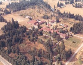
Aerial Photography

Taxonomy

Code

Scope note(s)

Source note(s)

Display note(s)

Hierarchical terms

Aerial Photography

Equivalent terms

Aerial Photography

Associated terms

Aerial Photography

824 Collections results for Aerial Photography

824 results directly related Exclude narrower terms

D155600-215C

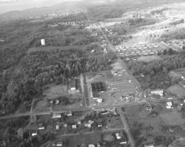
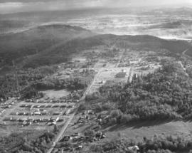
1969 Richards stock footage. Color aerial photograph of Marymount Military Academy, the only military school in Washington State; photograph taken in September of 1969. Built in 1922, the school was operated by the Dominican Sisters, a Catholic teaching order, and enrollment limited to boys 6-16. The school closed in 1976 due to insufficient enrollment and higher operating costs. In the 1980's, Harold LeMay would purchase the 80-acre property which would house much of his collection, the largest privately owned collection of automobiles in the world. Each August for the last 25 years, the LeMays have drawn thousands to the car show and open house at the former Marymount Academy. TPL-9104 (www.lemaymuseum.org)


Aerial views; Marymount Military Academy (Spanaway); Private schools--Spanaway; Military education--Spanaway;

D155048-1

Aerial photograph, looking west, of So. 19th & Mason neighborhood taken on November 8, 1968. Ballpark with lights on the left corner is Heidelberg Field. Land under development across the street from the ballpark is where the Fred Meyer Shopping Center eventually will be built. Glimpse of the Narrows Bridge on far upper portion of photograph. Photograph ordered by Morley Studios.


Aerial views; Neighborhoods--Tacoma--1960-1970; Heidelberg Field (Tacoma);

D155048-2

Aerial view of So. 19th & Mason neighborhood looking north toward Point Defiance. Gig Harbor area on upper left. Although the North end was heavily populated, there are still wooded areas remaining in late 1968. Ballpark is Heidelberg Field on So. 19th and Mason. Land directly across the street is being developed for a shopping center eventually featuring Fred Meyer. Street name would change to Stevens once it crosses So. 19th St.; wooded area across Stevens from future shopping center will later become apartments. Photograph ordered by Morley Studios. TPL-3803


Aerial views; Neighborhoods--Tacoma--1960-1970; Heidelberg Field (Tacoma);

D155600-361C

1969 Richards stock footage. Aerial view of Tacoma's north end featuring the No. 4th & D St. neighborhood. The Washington State Historical Building is located high above its neighbor, the Stadium Bowl, near the center of the photograph. The French Chateau-styled Stadium High School is on the extreme right edge of photograph.


Aerial views; Neighborhoods--Tacoma--1960-1970; Washington State Historical Building (Tacoma); Stadium Bowl (Tacoma); Stadium High School (Tacoma);

D155750-6

This is the Menlo Park and Sunset Beach area. Gravelly Lake Dr. is believed to be the road running horizontally surrounded by trees and homes. April, 1969, aerial views of the University Place area requested by Puget Sound National Bank. TPL-9241


Aerial views; Neighborhoods--University Place;

D155600-216C

1969 Richards stock footage. Parkland neighborhood featuring Pacific Lutheran University, Garfield St. and Pacific Avenue as viewed by air in September of 1969. Fall has come to the Pacific Northwest as yards have browned and the trees other than the numerous firs will soon lose their leaves. Looking west from Pacific Ave near the bottom of the photograph is the neighborhood around Pacific Lutheran University. Piggly Wiggly has a supermarket which is at the intersection of Garfield and Pacific; its large letters are clearly visible from the air. To the grocery store's right is believed to be Parkland Lutheran Church & School with its playground behind it. Pacific Lutheran University's upper campus buildings, surrounded by tall firs, are clustered in the center of the picture. Portions of McChord AFB can hazily been seen at the top of the photograph.


Aerial views; Pacific Lutheran University (Parkland)--1960-1970; Neighborhoods--Parkland; Piggly Wiggly (Parkland);

D155041-4C

November, 1968, aerial view of U.S. Oil & Refining plant on Tideflats. Petroleum storage tanks dot the landscape, part of the 120-acre plot owned by the U.S. Oil & Refining Co. The plant was built on land just south of Lincoln Ave. Closest waterway would be the Port Industrial Waterway. Photograph ordered by U.S. Oil & Refining.


Aerial views; Petroleum industry--Tacoma--1960-1970; US Oil & Refining Co. (Tacoma); Storage tanks--Tacoma;

D155600-236

ca. 1969. 1969 Richards stock footage. Burlington Northern line. View looking north of railroad tracks and Bayside Drive next to Commencement Bay. Bayside Drive would change its name to Ruston Way at the Old Town Dock near the top of the photograph. Eventually, Bayside would be absorbed and made wider by becoming Schuster Parkway. Famous restaurant Top of the Ocean near top of photograph; it would be destroyed by fire in April of 1977.


Aerial views; Railroad tracks--Tacoma--1960-1970; Top of the Ocean (Tacoma);

D155600-242

1969 Richards stock footage. View by air of the Tacoma Mall Shopping Center and newly built Tacoma Mall Office Building on July 1, 1969. A new addition to the Tacoma Mall Shopping Center was the 6-story Tacoma Mall Office Building, 4301 So. Pine. Designed by Olympia architects Bennett & Johnson and built by Cascade-Olympic Construction, the 2.7 million dollar structure was one of the first new major office buildings to be built in Tacoma in many years. The building was 90,000 square feet of reinforced concrete and came equipped with soundproof walls and air conditioning. Three high-speed elevators could be utilized to transport quickly customers and staff alike. The large lot provided plenty of free parking. It was conveniently located just off Pine St. and like the rest of the mall, freeway access was close by. The Tacoma Mall Office Building is still in service 36 years after its grand opening in March of 1969. Also shown above are the major stores of the Tacoma Mall: the Bon Marche, Nordstrom Best, and J.C. Penney. (TNT 8-4-68, A-11, TNT 10-27-68, B-11)


Aerial views; Tacoma Mall Office Building (Tacoma); Office buildings--Tacoma--1960-1970; Tacoma Mall Shopping Center (Tacoma); Shopping centers--Tacoma; Bon Marche (Tacoma); Nordstrom Best (Tacoma); J.C. Penney Co. (Tacoma);

D155041-10

ca. 1974. This aerial view of U.S. Oil & Refining Co. land was taken possibly on October 2, 1974. The company owned 120 acres south of Lincoln Avenue in the industrial Tideflats. A glimpse of Mount Rainier can be hazily seen in the background. Photograph ordered by U.S. Oil & Refining Co.


Aerial views; US Oil & Refining Co. (Tacoma);

D155600-355C

1969 Richards stock footage. Aerial look at newer Western Boat Building plant on Hylebos Waterway. The shipbuilding firm had moved to a seven-acre site on Marine View Dr., vacating the temporary quarters at the Port Industrial Yard it had occupied since fire destroyed their longtime plant on 11th St. One boat is under construction at far right edge of photograph.


Aerial views; Western Boat Building Co. (Tacoma); Boat & ship industry--Tacoma--1960-1970; Boats--Tacoma--1960-1970; Hylebos Waterway (Tacoma);

D155600-160C

ca. 1969. 1969 Richards stock footage. Unidentified group of buildings on the Hylebos Waterway viewed by air in 1969. Tracks are being built that lead from the water to probably transport logs in log boom. Many cars parked behind buildings.


Aerial views; Hylebos Waterway (Tacoma); Industrial facilities--Tacoma--1960-1970; Logs;

D155600-211C

1969 Richards stock footage. Autumn view of Kaiser Aluminum plant in tideflats taken by air in 1969. Located on Taylor Way approximately five miles north of downtown Tacoma, the large Kaiser facility had expanded in late 1968 to manufacture aluminum rods for shipment to California for finishing into electrical conductors. 1969 would see further expansion as its second alumina dome with a 100,000 ton capacity was completed on Pier 7.


Aerial views; Kaiser Aluminum & Chemical Corp. (Tacoma); Aluminum industry--Tacoma--1960-1970;

D155022-1

Northeast Tacoma residential neighborhoods with Commencement Bay in background. These aerial photographs were taken on behalf of Puget Sound National Bank on October 30, 1968. The bank had previously requested aerial views of neighborhoods when expansion of bank branches was anticipated.


Aerial views; Neighborhoods--Tacoma--1960-1970;

D155600-145

1969 Richards stock footage. Closer look at the large wooded area near Sixth Ave., James, No. 11th and No. 9th. Sixth Ave. is near the top half of photograph; Swasey branch library is near intersection of Howard and Sixth. No. 9th is street running nearly horizontal which appears to be swallowed by the woods. 11th St., near the right corner, intersects James which also appears to dead end in the woods.


Aerial views; Neighborhoods--Tacoma--1960-1970;

D155750-1

Aerial view of 40th & Bridgeport area in University Place. University Place's 400,000 gallon water tower is near mid-center; it is located on W. 40th between Bridgeport and Anderson. University Village Shopping Center featuring the Food King supermarket is slightly above and to the right of the water tower. Although University Place was becoming more developed by the late 1960's, there was still an abundance of wooded areas. Photograph requested by Puget Sound National Bank.


Aerial views; Neighborhoods--University Place;

D155750-8

Aerial view of Bridgeport Way toward the Sound taken on April 29, 1969. Bridgeport Way is meandering through the woods as it makes a slight curve toward the center of the photograph. 40th St. intersects Bridgeport at upper center with the University Village Shopping Center and water tower visible. Photograph ordered by Puget Sound National Bank.


Aerial views; Neighborhoods--University Place;

D155600-54

ca. 1969. 1969 Richards stock footage. Aerial view of the So. 19th & Tyler vicinity with Mount Rainier seen hazily in background. Cheney Stadium is on extreme right center with Heidelberg Field to its left. Henry Foss High School will be built in the wooded area close to both baseball fields.


Aerial views; Rainier, Mount (Wash.); Heidelberg Field (Tacoma); Cheney Stadium (Tacoma);

D155600-349C

1969 Richards stock footage. Closer aerial view of the Rodeway Inn of America under construction in the summer of 1969. Located near So. 72nd and the freeway, the Rodeway Inn would provide comfortable lodgings for the road-weary traveler. The two-story units were built in a modified U-shape. Constructed on five acres leased from Hillcrest Properties, the 130-unit complex was owned by Northwest Motel Co., Seattle. It would open for business in November of 1969. (TNT 11-2-69, D-14)


Aerial views; Rodeway Inn of America (Tacoma); Motels--Tacoma--1960-1970; Building construction--Tacoma--1960-1970;

D155600-351C

1969 Richards stock footage. A new motor inn was being built in the summer of 1969 at 6802 So. Sprague Ave., close to So. 72nd and the freeway. The Rodeway Inn of America was part of a large nationwide chain of motels. Its blue and white logo was a familiar sign to budget conscious travelers who could be assured of comfortable rooms and reasonable prices. Built at a cost of 1.25 million dollars, the 130-unit complex was managed by Johnny H. Lambert. It would offer a restaurant/lounge, heated swimming pool, convention and banquet facilities and meeting rooms. The luxury motel hotel would be open for business in early November, 1969. (TNT 11-2-69, D-14)


Aerial views; Rodeway Inn of America (Tacoma); Motels--Tacoma--1960-1970; Building construction--Tacoma--1960-1970; Signs (Notices);

D155022-3

Aerials of the Northeast Tacoma - Federal Way area taken on October 30, 1968, on behalf of Puget Sound National Bank. Development is occurring in this location although there is still much forested land. Looking due north, attention is drawn to the long vertical roadway of 21st Ave. S.W. which is in Federal Way. As the road curves toward the left, it becomes 29th St. N.E. in Tacoma. When 21st Ave. splits off to the right, it becomes 356th St. S.W., again in Federal Way. A small shopping center, anchored by National Auto Parts (black roof), faces 21st Ave. S.W. Mosier's Enco Service Station, 35455 21st Ave. S.W., is directly across Blaser's Richfield Service Station on S.W. 356th St. A large water tower emerges from the woods in the upper left section of the picture.


Aerial views; Aerial photographs; Neighborhoods--Federal Way--1960-1970; Neighborhoods--Tacoma--1960-1970; National Auto Parts (Federal Way); Mosier's Enco Service Station (Federal Way); Blaser's Richfield Service Station (Federal Way); Water towers;

D155022-9

This aerial view of the area looking east on 29th St. N.E. was taken in late October of 1968. In the immediate foreground is the Northeast Tacoma Elementary School, 5412 - 29th St. N.E., designed by the architectural firm of Heath, Gove & Bell and built in 1919 with additions following in 1959 and 1973. The black rooftops of the small shopping center containing the National Auto Parts and Walkley's Pharmacy can be seen mid-center of the photograph. Photograph ordered by Puget Sound National Bank.


Aerial views; Aerial photographs; Neighborhoods--Tacoma--1960-1970; Neighborhoods--Federal Way--1960-1970; Northeast Tacoma School (Tacoma);

D155600-68C

1969 Richards stock footage. Looking quite a bit different in May of 1969, the area around So. 72nd and the freeway was starting to be developed commercially. The new Rodeway Inn of America was under construction at 6802 So. Sprague, close to the freeway. Travelers could easily exit the freeway to find comfortable lodgings. A Standard Oil station was conveniently located nearby. The 130-unit luxury motor hotel opened in early November, 1969, with a 90-unit addition planned. (TNT 11-2-69, D-14)


Aerial views; Building construction--Tacoma--1960-1970; Rodeway Inn of America (Tacoma); Motels--Tacoma--1960-1970; Automobile service stations--Tacoma--1960-1970;

D155600-450C

ca. 1969. 1969 Richards stock footage. Aerial view of Eastern Oil operations in 1969. Storage tanks dot the landscape of the large site on Marine View Dr. N.E. facing the Hylebos Waterway. Although tentatively identified as "Eastern Oil," it is possible that this is actually the Sound Refining Co., located on the northwest edge of the Tideflats. Sound Refining began operations in 1967 as a crude oil refinery.


Aerial views; Eastern Oil Co. (Tacoma); Storage tanks--Tacoma;

D155022-10

Aerial views of Northeast Tacoma/Federal Way. Small section of businesses on right side includes a Richfield service station and an automotive parts store with large parking lot. This particular October, 1968, photograph focuses on a small shopping center which is actually on 21st Ave. S.W. in Federal Way. The businesses included National Auto Parts, Walkley's Pharmacy, Mosier's Enco Service Station and where 21st Ave. turns into S.W. 356th St., Blaser's Richfield Service Station. Photograph ordered by Puget Sound National Bank probably for bank expansion.


Aerial views; Aerial photographs; Neighborhoods--Tacoma--1960-1970; Neighborhoods--Federal Way--1960-1970; National Auto Parts (Federal Way); Mosier's Enco Service Station (Federal Way); Blaser's Richfield Service Station (Federal Way);

D155022-11

This view of northeast Tacoma near the border with King County dates from October of 1968. The road cutting through the image from top left to bottom right is 29th Street N.E. Northeast Tacoma Elementary School at 5412 29th St. N.E. is just visible near the upper left corner. Much of the area is still heavily wooded, but a small, new shopping center, featuring National Auto Parts, Walkley's Pharmacy and Mosier's Enco Service Station, is located mid-center on 21st Ave. S.W. in Federal Way.


Aerial views; Aerial photographs; Neighborhoods--Tacoma--1960-1970; Neighborhoods--Federal Way--1960-1970; Northeast Tacoma School (Tacoma); National Auto Parts (Federal Way); Mosier's Enco Service Station (Federal Way);

D155600-75C

1969 Richards stock footage. Closer look by air at the 7-month-old Aladdin Apartments, located in the city's south end at 2112 So. 90th St. The upscale apartment complex, built by developer Oscar Hokold, was opened in September of 1968. Residents of the one and two bedroom units enjoyed such amenities as spacious bedrooms, wall-to-wall carpeting, soundproofing and dishwashers. All had views of the landscaped greens and swimming pool area.


Aerial views; Aladdin Apartments (Tacoma); Housing developments--Tacoma--1960-1970;

D155600-440C

1969 Richards stock footage. Color aerial view of Export Pacific Co. By 1969, Export Pacific's address had changed from 900 Milwaukee Way to 1942 E. 11th, next door to the Brown & Haley Distribution Division. Still headed by Chauncey L. Griggs, the firm remained in the lumber export business while sharing the address with the Export Pacific Grain Co.


Aerial views; Export Pacific Co. (Tacoma); Shipping--Tacoma--1960-1970;

D155022-A

Aerial views of Northeast Tacoma/Federal Way neighborhoods requested by Puget Sound National Bank. The area was still heavily wooded in October of 1968. Puget Sound National Bank may have been photographing Northeast Tacoma and adjoining Federal Way in anticipation of opening a new branch in the area. In mid-center of the photograph is a small shopping center that held the National Auto Parts store, Walkley's Pharmacy, and Mosier's Enco Service Station. It was located on 21st Ave. S.W. in Federal Way. 21st Ave. S.W. turns in one direction into 29th St. N.E. which is in Tacoma; when it turns the other way it develops into S.W. 356th St. in Federal Way.


Aerial views; Aerial photographs; Neighborhoods--Tacoma--1960-1970; Neighborhoods--Federal Way--1960-1970; National Auto Parts (Federal Way); Mosier's Enco Service Station (Federal Way);

D155600-72C

1969 Richards stock footage. Aerial view of the Aladdin Apartments, 2112 So. 90th St., which were completed in 1968. Built by local developer Oscar Hokold, the units were all electric and rented for $135 and up. The Aladdin was centrally located, close to the freeway and mere minutes from the Tacoma Mall.


Aerial views; Aladdin Apartments (Tacoma); Housing developments--Tacoma--1960-1970;

Results 631 to 660 of 824