Aerial Photography

Taxonomy

Code

Scope note(s)

Source note(s)

Display note(s)

Hierarchical terms

Aerial Photography

Equivalent terms

Aerial Photography

Associated terms

Aerial Photography

824 Collections results for Aerial Photography

824 results directly related Exclude narrower terms

D137300-112

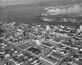
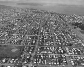
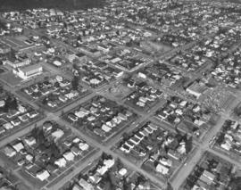
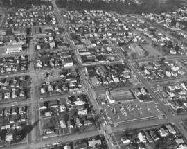
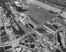
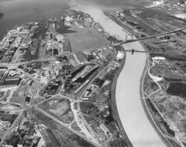
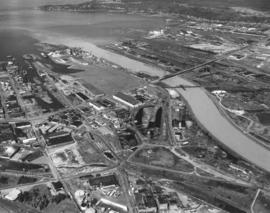
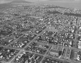
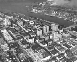
ca. 1963. Closer view of downtown business district, City Waterway, and industrial Tideflats taken by air in 1963. The entrance to the 11th St. Bridge leading to the Tideflats separates the Tacoma and Perkins Buildings. Close by are Puget Sound National Bank's headquarters with its tall steeple, Peoples department store, Washington Building, Rust Building and the Bank of California. St. Regis' smokestacks in the Tideflats spew clouds of smoke as the plant performs around-the-clock operations.


Aerial photographs; Commercial streets--Tacoma--1960-1970; Tacoma Building (Tacoma); Perkins Building (Tacoma); Puget Sound National Bank (Tacoma); Peoples (Tacoma); Washington Building (Tacoma);

D137300-113

ca. 1963. Overview of downtown Tacoma area looking east including City Waterway, industrial areas, taken by air in 1963. Central School, the County-City Building, and Tacoma Public Library's Main branch and Carnegie Building are shown from the rear in photo's center. Washington State Armory with black roof and Tacoma Vocational-Technical School (Bates) with radio tower across the street on 11th & Yakima. Parts of the Tideflats on various waterways can be seen including busy St. Regis Paper Co.


Aerial photographs; Commercial streets--Tacoma--1960-1970; County-City Building (Tacoma); Tacoma Public Library (Tacoma); Central School (Tacoma); State Armory (Tacoma); Tacoma Vocational School (Tacoma);

D137300-114

ca. 1963. Aerial photograph of Sixth Avenue with Jason Lee Junior High (now Middle) School nearby. Homes and businesses on either side of Sixth Avenue in 1963 were close-in with little available open land. Children in the neighborhood would probably have attended Jason Lee Junior High School on 6th & Sprague. The Tudor-styled school was built in 1924 at the site of the old campus of the College of Puget Sound. It was named in honor of early northwest missionary Jason Lee. Sixth Avenue would provide a vital connection of downtown Tacoma on the east with the Narrows Bridge and Titlow Beach on the west.


Aerial photographs; Neighborhoods--Tacoma--1960-1970; Jason Lee Junior High School (Tacoma);

D137300-125C

ca. 1963. Vista Manor with Stadium H.S. in background. Color 1963 aerial photograph of Tacoma's north end focusing on the 16-story Vista Manor Apartments and Central Lutheran Church on Tacoma Avenue North and Washington State Historical Building, Stadium Bowl and Stadium High School on bluff overlooking Commencement Bay. Tideflats in distance. One ship is docked below the school.


Aerial photographs; Stadium Bowl (Tacoma); Stadium High School (Tacoma); Washington State Historical Building (Tacoma); Neighborhoods--Tacoma--1960-1970; Central Lutheran Church (Tacoma); Vista Manor Apartments (Tacoma);

D137300-127C

ca. 1963. Stadium High School on Stadium Way enjoyed elevated views of Commencement Bay. This 1963 aerial photograph shows the school's proximity to the Washington State Historical Society Building juxtaposed with massive Stadium Bowl, site of football and civic endeavors. Stadium High School had been planned as a grand Tacoma hotel but it was gutted by fire before completion. It opened as a high school in 1906 and changed its name to Stadium in 1913. The school will be undergoing extensive remodeling starting in 2004 and its students transferred to the old Mount Tacoma High School.


Aerial photographs; Stadium High School (Tacoma); Washington State Historical Building (Tacoma); Washington State Historical Society (Tacoma); Neighborhoods--Tacoma--1960-1970;

D137300-13

Aerial view of Stadium District in the city's northend, including turreted Stadium High School, Stadium Bowl, and State Historical Museum on the hillside overlooking the Bowl and with views of Commencement Bay. The school's tennis courts are to the right. Part of Richards stock file, taken on February 9, 1963. TPL-10143


Aerial photographs; Stadium High School (Tacoma); Public schools--Tacoma--1960-1970; Stadium Bowl (Tacoma); Washington State Historical Building (Tacoma); Washington State Historical Society (Tacoma); Neighborhoods--Tacoma--1960-1970;

D137300-137

Aerial view of Reichhold Chemicals facilities taken on March 29, 1963. Located in the Tideflats industrial area, Reichhold Chemicals first established their plant on 51 acres on Lincoln Avenue in 1956. The Tacoma plant was the headquarters for the national company's Pacific Northwest Division. Reichhold's manufactured chemicals for Pacific Northwest industries, including the large plywood field. A railroad spur was built on company property that would ship products directly into Tacoma and beyond. By 1963, the company was listed in the City Directory at 2340 Taylor Way.


Aerial photographs; Reichhold Chemicals, Inc. (Tacoma); Chemical industry--Tacoma--1960-1970;

D137300-138

Another view of Reichhold Chemicals plant, including ponds, storage tanks and outer buildings, taken by air on March 29, 1963. Reichhold's had purchased 51 acres of land in the Tideflats in 1956 so that the national producer of chemicals had plenty of room for expansion. They were originally located at 3320 Lincoln Avenue but by 1963 had apparently moved to 2340 Taylor Way. TPL-6579


Aerial photographs; Reichhold Chemicals, Inc. (Tacoma); Chemical industry--Tacoma--1960-1970;

D137300-139

ca. 1963. Swooping down on Tacoma's north end to display Vista Manor Apartments and Central Lutheran Church, both on Tacoma Avenue North with Washington State Historical Museum Building on Stadium Way overlooking Stadium Bowl. Portions of Commencement Bay are visible at top of this 1963 aerial photograph. The church was constructed of reinforced concrete and brick in 1957; it was approved as a fallout shelter in 1962. The 25' cross, painted white, on the tower of the church revolved four times each minute. The steel cross was lighted at night. It was given by the congregation in memory of the late Dr. William Rosenbladt. Across the street at 319 Tacoma Avenue No. were the Vista Manor Apartments; the 16-story building was also approved as a fallout shelter in 1962. (TNT 12-23-62, A-5)


Aerial photographs; Stadium Bowl (Tacoma); Washington State Historical Building (Tacoma); Washington State Historical Society (Tacoma); Neighborhoods--Tacoma--1960-1970; Central Lutheran Church (Tacoma); Vista Manor Apartments (Tacoma);

D137300-140

ca. 1963. 1963 aerial photographs of Tacoma Avenue North with focus on Central Lutheran Church on left of photograph and 16-story white tower of Vista Manor Apartments across the street. The 133-unit apartment building was designed by architects Lance, McGuire & Muri and built by C.F. Davidson in 1950. Both it and Central Lutheran were designated as fallout shelters in 1962. TPL-866


Aerial photographs; Neighborhoods--Tacoma--1960-1970; Vista Manor Apartments (Tacoma); Central Lutheran Church (Tacoma);

D137300-141

ca. 1963. Aerial photographs looking from North 4th & Tacoma Avenue North towards Stadium Way. This 1963 picture shows the historic north end district with the State Historical Society Building overlooking Stadium Bowl and the turret and towered high school nearby. A ship is docked below the Stadium; name is possibly States Marine Lines. Central Lutheran Church with dark roof and 16-story Vista Manor Apartments are located on Tacoma Avenue North. TPL-867


Aerial photographs; Neighborhoods--Tacoma--1960-1970; Stadium High School (Tacoma); Stadium Bowl (Tacoma); Washington State Historical Building (Tacoma); Central Lutheran Church (Tacoma); Vista Manor Apartments (Tacoma);

D137300-142

ca. 1963. Another of a series of aerial photographs taken in 1963 of the neighborhoods around Tacoma Avenue North, featuring the white tower of Vista Manor Apartments and the Central Lutheran Church. Many of the dwellers of "Old Town, " including Vista Manor occupants, would have splendid views of the water. TPL-868


Aerial photographs; Vista Manor Apartments (Tacoma); Central Lutheran Church (Tacoma); Neighborhoods--Tacoma--1960-1970;

D137300-172

Aerial view in March, 1963, of multiple stacks of plywood sheets ready for shipment. Richards Studio notes indicate this is a St. Paul & Tacoma site; it had merged with St. Regis Paper Co. to become an operating subsidiary in 1957. St. Paul & Tacoma, established in 1888, had a large sawmill with dry kilns and a planing mill. It operated the largest retail lumber yard in the state of Washington.


Aerial photographs; Plywood; St. Paul & Tacoma Lumber Co. (Tacoma); St. Regis Paper Co. (Tacoma)--1960-1970; Lumber industry--Tacoma--1960-1970;

D137300-40

Aerial photographs of the city's northend were taken on March 2, 1963. Street running vertically on right side of photograph is No. 21st St.; note many towers spaced in middle of street. Between No. 21st and No. 26th Sts. is Downing Elementary School at 2502 No. Orchard.


Aerial photographs; Neighborhoods--Tacoma--1960-1970; Mont Downing Elementary School (Tacoma);

D137300-43

March, 1963, aerial photographs of Tacoma's populous northend and view of Commencement Bay. Located on right side with trees is the University of Puget Sound. Jefferson Park is on the left lower portion of photograph, with Proctor St. on its right and No. 9th St. above. No. 21st St. runs horizontally near the top of the photograph; the street is marked with towers and the Cushman Power Station.


Aerial photographs; Neighborhoods--Tacoma--1960-1970; Jefferson Park (Tacoma); University of Puget Sound (Tacoma)--1960-1970;

D137300-44

ca. 1963. 1963 aerial photographs taken by the Richards Studio of the city's northend neighborhoods show streets laid out neatly in a grid, looking northward toward the water. Jefferson Park, on the bottom of the photograph, at No. 9th had a large hitting park. The Cushman substation is toward the upper center portion of the photograph on No. 21st St. The wooded University of Puget Sound campus is to the right. The heavily treed area nearly reaching the water is Puget Park. TPL-9197


Aerial photographs; Neighborhoods--Tacoma--1960-1970; Jefferson Park (Tacoma);

D137300-46

ca. 1963. The Proctor shopping area in 1963 looks much as it currently does in 2004 judging from this aerial photograph taken by the Richards Studio. Washington Elementary School on No. 26th St. is upper middle section; across the street is Tacoma Public Library's McCormick (now Wheelock) Branch. Safeway has a large grocery store a block away from the library. Mason Methodist Church is the large structure on No. 28th St. TPL-9198


Aerial photographs; Neighborhoods--Tacoma--1960-1970;

D137300-49

ca. 1963. Closer aerial view looking north of the No. 26th & Proctor District taken in 1963. Safeway's store in the 2400 block of No. Proctor provided a large parking lot for its customers. It was one of the many businesses and services in the neighborhood. School children in the area might have attended Washington Elementary School and Hoyt Primary School, on No. 26th and Union Ave., respectively. Books could be read at the McCormick Branch Library at the corner of No. 26th & Adams, part of the Tacoma Public Library system. The round building under construction on No. 26th would later become a bank. TPL-9199


Aerial photographs; Neighborhoods--Tacoma--1960-1970;

D137300-498

View by air of Washington State Historical Building and vicinity on No. Stadium Way on August 24, 1963. No. 4th is the next street over. Large empty space is believed to be the museum's parking lot. This section of the Historical Society's building would overlook the waters of Commencement Bay which would be visible beyond the trees.


Aerial photographs; Washington State Historical Building (Tacoma); Washington State Historical Society (Tacoma); Neighborhoods--Tacoma--1960-1970;

D137300-499

ca. 1963. Aerial photograph of 11th St. heading in an easterly direction ca. 1963. Waterway is believed to be the Puyallup Waterway; the East 11th St. Bridge is located midway. Many industrial facilities packed in this section of the Tideflats. Large log booms rest in the protected waterways until they are needed by various mills.


Aerial photographs; Logs; Industrial facilities--Tacoma--1960-1970; Bridges--Tacoma--1960-1970;

D137300-500

ca. 1963. Taken from a southern aerial view in 1963 is a portion of the Tacoma Tideflats industrial area. Large curving waterway is the Puyallup Waterway. Bridge is on East 11th Street and is called simply the "East 11th St. Bridge."


Aerial photographs; Bridges--Tacoma--1960-1970; Puyallup Waterway (Tacoma);

D137300-502

ca. 1963. Another in a series of aerial photographs taken of the Tacoma Tideflats in 1963; this features the Puyallup Waterway and 11th Street. The bridge on 11th over the Puyallup is called the East 11th St. Bridge.


Aerial photographs; Bridges--Tacoma--1960-1970; Puyallup Waterway (Tacoma) ; Industrial facilities--Tacoma--1960-1970;

D137300-51

This is what the area surrounding Puget Park north of the Proctor District looked like by air in March of 1963. Proctor is the long street running vertically through the park; North 30th is the street running horizontally near the bottom. The houses in Tacoma's northend neighborhoods are clustered tightly together; many would have outstanding views of Commencement Bay. TPL-9696


Aerial photographs; Puget Park (Tacoma); Neighborhoods--Tacoma--1960-1970;

D137300-52

ca. 1963. Aerial views of neatly laid out neighborhood streets of north Tacoma, taken in 1963. The trees toward the upper portion of the photograph are part of Puget Park. Running horizontally a few blocks below the park is No. 21st St. with its towers and the Cushman power substation. Large building near top of photograph but below park is believed to be the Mason Methodist Church on No. 28th St. TPL-9300


Aerial photographs; Neighborhoods--Tacoma--1960-1970;

D137300-529

Aerial view of the Fircrest area taken in September, 1963. The City of Fircrest is nestled among trees towards the center of the photograph. The Narrows Bridge can be seen towards the upper portion of the picture. Point Defiance Park and vicinity is at top center; the ASARCO smelter appears pencil-thin not far away. Vashon Island is large island above the smelter. Lakewood area is towards the left edge of picture. TPL-9301


Aerial photographs; Neighborhoods--Fircrest; Tacoma Narrows Bridge (Tacoma);

D137300-530

Closer aerial view of heavily forested Fircrest area on September 18, 1963. Fircrest is located east of University Place, west of Tacoma. Its population in the early 1960's was about 3600. The Narrows Bridge can be spotted toward the top left corner of the photograph.


Aerial photographs; Neighborhoods--Fircrest; Tacoma Narrows Bridge (Tacoma);

D137300-531

September 18, 1963, aerial of I-5 freeway in vicinity of Tacoma Mall under construction. The light colored flat area towards the top center is the future location of the Tacoma Mall shopping center. Easy freeway access and ample free parking would draw thousands to the mall for shopping. The Tacoma Mall would have its official opening in October, 1965.


Aerial photographs; Express highways--Tacoma--1960-1970; Shopping centers--Tacoma;

D137300-54

This March 2, 1963, aerial photograph shows more closely the Cushman substation and its various towers. The substation is located on No. 21st. near Proctor. The Proctor District offered many businesses and services to those residing in its neighborhoods, including a library, schools, and churches. The heavily wooded Puget Park is located nearby. TPL-3802


Aerial photographs; Neighborhoods--Tacoma--1960-1970;

D137300-77

ca. 1963. Aerial photographs taken in 1963, looking west, of portions of Puyallup. The large building in the lower center of the photograph has been identified as Puyallup High School. To its right is the gym. Tennis courts are on the square to the left. Behind the main building is the science/library/arts building. Pioneer Ave. is to the left. To the right is Main St. which splits the school between the main building and the gym. (Additional information and identification provided by a reader)


Aerial photographs; Neighborhoods--Puyallup--1960-1970; Puyallup High School (Puyallup); Public schools--Puyallup; Streets--Puyallup;

D137300-78

ca. 1963. 1963 aerial view of Puyallup. Puyallup River at top of photograph. Football field at lower right corner.


Aerial photographs; Neighborhoods--Puyallup--1960-1970; Puyallup River (Wash.);

Results 271 to 300 of 824