Aerial Photography

Taxonomy

Code

Scope note(s)

Source note(s)

Display note(s)

Hierarchical terms

Aerial Photography

Equivalent terms

Aerial Photography

Associated terms

Aerial Photography

824 Collections results for Aerial Photography

824 results directly related Exclude narrower terms

A53195-14

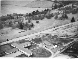
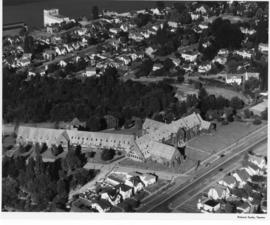
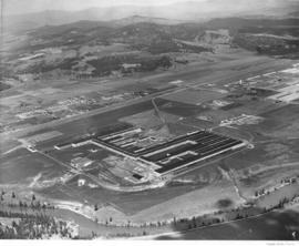
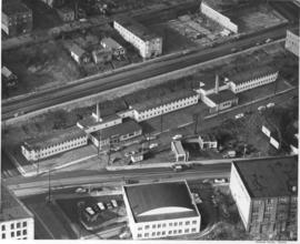
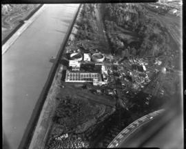
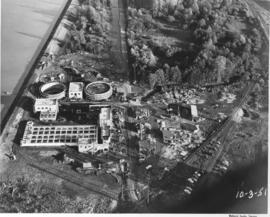
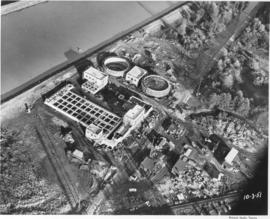
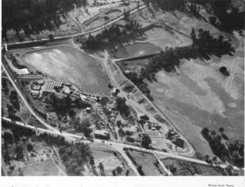
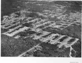
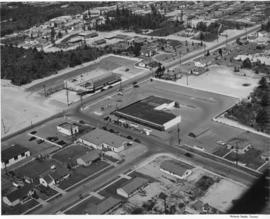
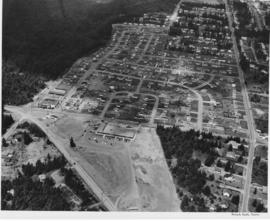
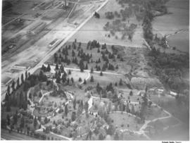
ca. 1950. Aerial view of Mountain View Cemetery on Steilacoom Blvd.; photograph taken probably in the fall of 1950. The Pacific Naval Advance Base, also known as the Lakewood Navy Yard, lies across the street. Mountain View was a very large memorial park; among its facilities included a cemetery, funeral home, chapel, crematorium and mausoleum. According to an advertisement in the 1951 City Directory, a mourner could place complete responsibility in the very capable hands of Mountain View.


Aerial photographs; Mountain View Memorial Park (Lakewood); Pacific Naval Advance Base (Lakewood); Lakewood Navy Yard (Lakewood);

A53195-6

ca. 1950. Aerial photograph of Pacific Naval Advance Base in Lakewood taken probably in the fall of 1950. Mountain View Cemetery with its expansive grounds lies across the street on Steilacoom Blvd. The Navy acquired the land to build its base in 1944; previously it had been used for the Tacoma Municipal Airport. The Pacific Naval Advance Base was also known more familiarly as the Lakewood Navy Yard.


Aerial photographs; Pacific Naval Advance Base (Lakewood); Lakewood Navy Yard (Lakewood); Mountain View Memorial Park (Lakewood);

A53195-12

ca. 1950. Aerial view of South Tacoma Way at Steilacoom Blvd. was taken probably in the fall of 1950. This was near South 96th-100th Streets. Although the area is starting to become developed, there is still a lot of vacant land available.


Aerial photographs; Land--Tacoma--1950-1960; Commercial streets--Tacoma--1950-1960;

A53195-3

ca. 1950. Aerial view of landscape close to Steilacoom Blvd. was taken probably in the fall of 1950. The area was slowly developing; however, there was still much room for expansion. Developers did manage to leave much of the tall foliage around the homes.


Aerial photographs; Neighborhoods--Lakewood--1950-1960; Land use--Lakewood--1950-1960;

A53195-4

ca. 1950. It appears that a number of aerial photographs of the Lakewood area were taken in the fall of 1950. The area was slowly growing and developing; this particular neighborhood seems to be of mixed usage with businesses and homes scattered among the tall trees.


Aerial photographs; Neighborhoods--Lakewood--1950-1960; Land use--Lakewood--1950-1960;

A53173-1

ca. 1950. Aerial view of Annie Wright Seminary, from Tacoma Ave. No. to Commencement Bay in the North end of Tacoma. The heavily wooded area between the school and the Stadium district is Garfield Park. Annie Wright Seminary was endowed by Northern Pacific Railroad's President C. B. Wright, with an original grant of $50,000. The school was named for his daughter Annie. It opened in 1884 with 94 students, at its original location of 611 Division Ave. It was moved to this location in 1924.


Annie Wright Seminary (Tacoma)--1950-1960; Private schools--Tacoma; Aerial photographs; Annie Wright Seminary (Tacoma)--Buildings

D53468-8

Scenic views from Eastern Washington. An aerial view of farm land, a sprawling building in the center, a plant in the upper right with what may be a Ralston Purina logo painted on a tower, and a small residential community in the upper left in one of the broad valleys of eastern Washington. A narrow river meanders through the foreground.


Land; Valleys--Washington; Rivers; Industrial facilities;

D53468-35

Scenic views from Eastern Washington. An aerial view of the housing area across the Columbia River from the utility facilities at Grand Coulee Dam. Mason City was built on one side of the river during the dam construction and Engineer's Town grew on the opposite side. This view shows the land forms above the river into the distance.


Columbia River (Wash.); Land; City & town life;

A62921-1

An aerial view of the Fibreboard Plant in Sumner. The corrugated box plant had operated in Sumner since 1920. The plant was sold to Louisiana-Pacific Corp. in 1978 who planned to sell the division to a company that was in the container business. Ordered by Moulin Studio. (TNT, 10/10/1978)


Aerial photographs; Fibreboard Corp. (Sumner); Paper industry--Sumner;

A62426-2

Aerial photographs were taken of Jefferson Avenue in November, 1951. Building on the right hand corner belongs to Blake, Moffitt & Towne, wholesale distributors of printing and wrapping paper. Rectangular two-story buildings in center of photograph are probably structure known as "Jefferson House", built originally in 1945 to provide emergency accomodations for single men. Jefferson Avenue was primarily a business district, filled with apartment buildings and manufacturers. Photograph ordered by John Huston.


Aerial photographs; Cityscapes; Commercial streets--Tacoma--1950-1960;

D61250-3

Aerial view of sewage disposal plant. Hoagland and Findlay. Sewage treatment plan under construction. Wide canal on left.

D61250-1

Aerial view of sewage disposal plant. Progress photograph of the new sewage disposal plant on Cleveland Way was taken by air on October 3, 1951. Construction continues on the new plant near the Puyallup River under the direction of Hoagland-Findlay Engineering Company who had the low bid of nearly $1,400,000. The two large circular structures are digesting tanks where raw sewage would be digested and eventually turned into fertilizer. Rectangular building appears to be a 14,000,000 gallon sedimentation tank. Photograph commissioned by Hoagland-Findlay. TPL-8824


Aerial photographs; Progress photographs; Building construction--Tacoma--1950-1960; Sewerage--Tacoma; Waste disposal facilities--Tacoma; Hoagland-Findlay Engineering Co. (Seattle);

D61250-2

Aerial photograph of sewage disposal plant. Progress was being made in the construction of a new waste disposal facility on Cleveland Way near the Puyallup River in October, 1951. Aerial view of plant; large circular structures are digesting tanks, square building between them the digestion control building. Raw sludge would be processed in the digesting tanks where ultimately it would be filtered, peeled off in cakes, and then hauled away for fertilizer. According to a 12/12/51 article in the News Tribune, the plant was designed to handle 27 million gallons of sewage a day. Photograph commissioned by Hoagland-Findlay. TPL-8825


Aerial photographs; Progress photographs; Building construction--Tacoma--1950-1960; Sewerage--Tacoma; Waste disposal facilities--Tacoma; Hoagland-Findlay Engineering Co. (Seattle);

A60604-2

Aerial photographs of Mountlake Terrace were taken on August 16, 1951. Developers of this neighborhood near Seattle left many of the trees in the heavily forested area for homeowners to enjoy. Cul-de-sacs were starting to emerge as part of suburban lifestyles, to lessen amount of traffic on roads next to homes and provide safer play areas for children. Photograph commissioned by Budget Homes, Inc.


Aerial photographs; Housing developments--Mountlake Terrace;

A60608-1

Aerial photograph of the scenic Columbia River was taken on August 17, 1951. Shadows are falling on the rocky tree-covered hills. There does not appear to be any river traffic at this particular moment in time.


Aerial photographs; Columbia River (Wash.); Rivers--Washington (State);

A60069-3

Aerial photographs of the Holroyd plant were taken in July, 1951. The Holroyd Company was located at 5047 South Washington; they specialized in making concrete masonry units but also manufactured different types of building materials. They also dealt with sand and gravel and steel windows, according to an entry in the 1951 City Directory. Large lake pictured may have been used for manufacturing purposes.


Aerial photographs; Holroyd Co. (Tacoma); Concrete products industry--Tacoma--1950-1960; Building materials industry--Tacoma--1950-1960; Concrete--Tacoma;

A60067-1

In July of 1951 a massive addition to the Lakewood Community Center at 6100 Motor Avenue S.W. in Lakewood was under construction. The original center, built by Norton Clapp, opened in July of 1937. With the addition, several new stores were added to the center including Selden's Lakewood. The Lakewood Community Center was one of the country's first one-stop shopping centers. Photograph commissioned by St. Paul & Tacoma Lumber Co. TPL-4412


Aerial photographs; Lakewood Community Center (Lakewood); Progress photographs; Shopping centers--Lakewood--1950-1960;

A60604-6

Aerial photographs of Mountlake Terrace in August, 1951, show the growing development of the neighborhood near Seattle. Surrounded by heavily forested land, city streets are gradually being laid out and homes built. Developers managed to retain many of the trees while building the new homes. Photograph commissioned by Budget Homes, Inc.


Aerial photographs; Housing developments--Mountlake Terrace;

A59833-1

An aerial view of the new pre-fab plant of Bethlehem Pacific Coast Steel Corporation along a waterway at 8501 East Marginal Way, Seattle.The Seattle Fabricating Works of Bethlehem Pacific was the newest plant in the nation capable of fabricating steel for large buildings, bridges and towers. It was built in 1950 on 8 acres of land on East Marginal Way, across from Boeing Field. It normally had about 250 employees. In the plant, structural steel and plates are cut, punched, drilled, bent, machined and prepared for erection.


Bethlehem Pacific Coast Steel Corp. (Seattle); Aerial photographs; Factories--Seattle;

A58908-1

This aerial view of the St. Paul & Tacoma Lumber Company shows Mount Rainier in the background. Included in the photograph are the sawmill, lumber storage and shipping sheds, planing mill, dry kilns, and the barking and chipping plant. The log storage and sorting ponds, railroad log dumps, deep water shipping dock and shed are not shown, as the plant covers an area of 180 acres, about 1/4 mile wide and a mile long. The company sprawled along the St. Paul Waterway, to the left of this photograph, between St. Paul and Portland Avenues. The Puyallup River can be seen heading east with several bridges crossing it. Ordered by St. Paul & Tacoma Lumber Company. (Tree Life Hemlock, St. Paul & Tacoma Lumber Co.)


Aerial photographs; St. Paul & Tacoma Lumber Co. (Tacoma); Cityscapes; Lumber industry--Tacoma--1950-1960;

A58591-5

Ariel photograph ordered by Tacoma Powdered Metals at 1501 East Taylor Way, Les Toulouse. A railroad spur has been added along the side of the building with loading docks available. A sign on the building announces Purex-trend.


Aerial photographs; Industry--Tacoma--1950-1960; Railroad sidings--Tacoma; Chemical industry--Tacoma--1950-1960; Purex Corp. (Tacoma);

D58919-1

An aerial photograph of the Northgate shopping area. The building in the center of this June, 1951, photograph contains Larson's Department Store and Ridgecrest Super Market. Ordered by Phares Advertising. The area is mixed use with single-family residential areas near this commercial area.


Aerial photographs; Shopping centers--Seattle; Land use--Seattle--1950-1960; Real estate development--Seattle--1950-1960;

D67903-4

ca. 1952. Aerial photograph of residential area, most probably Mountlake Terrace, circa 1952. Mountlake Terrace was an expanding area north of Seattle, in Snohomish County, just north of the King county line. The largely residential area served as a bedroom community for Seattle workers. The area surrounding is still heavily forested and undeveloped. The streets are laid out in curves, forming cul de sacs.


Aerial photographs; Housing developments--Mountlake Terrace;

D67903-9

ca. 1952. Aerial view of Northern King County, north of Seattle and west of Lake Washington. The large building on the left with the marquee is most probably the Crest Movie Cinema, located at 16505 5th Ave. NE, Seattle. The homes here appear to mid sized and are located on large lots. The streets are laid out on a square block formation. There are still large sections of woods in view.


Aerial photographs; Aerial views; Housing developments--Seattle; Neighborhoods--Seatte;

D67903-2

ca. 1952. Aerial photograph of residential area, most probably Mountlake Terrace. Mountlake Terrace was an expanding area north of Seattle, in Snohomish County, just north of the King county line. The largely residential area served as a bedroom community for Seattle workers. The area surrounding is still heavily forested and undeveloped. The streets are laid out in curves, forming cul de sacs.


Aerial photographs; Housing developments--Mountlake Terrace;

A66035-40

Aerial view of 1952 Daffodil Parade as it proceeds down Pacific Avenue. The day of the parade dawned clear and sunny, prompting 200,000 Tacomans to line the parade route. People stood 10 deep at prime viewing spots, with others watching from windows, awnings, hanging from fire escapes and perching on roofs.


Celebrations--Tacoma; Festivals--Tacoma; Parades & Processions--Tacoma--1950-1960; Puyallup Valley Daffodil Festival (1952 : Tacoma); Drill teams; Marching bands; Floats (parades)--Tacoma--1950-1960; Aerial photographs;

A66035-36

Aerial view of 1952 Daffodil Parade as it proceeds down Pacific Avenue. The 15 mile long parade wound its way down Pacific Ave. from 9th to 19th. A Marine Corps color guard led the parade, followed by the float bearing Queen Eva Beattie and her princesses, royally escorted by the Rosarians of Portland, Oregon. Following the City Light float bearing the Queen were 70 floats and decorated cars, 21 bands, 28 marching units and three mounted groups. (TNT 4-6-1952, pg. 1)


Celebrations--Tacoma; Festivals--Tacoma; Parades & Processions--Tacoma--1950-1960; Puyallup Valley Daffodil Festival (1952 : Tacoma); Drill teams; Marching bands; Floats (parades)--Tacoma--1950-1960; Aerial photographs;

A64784-1

An aerial view of the new multiwall bag plant at St. Regis. The plant was completely equipped to produce a full range of multiwall bags. Equipment included six production lines, three printing presses, a complete art and engraving department and auxiliary equipment. This plant replaced a leased plant in Seattle. (TNT, 10/19/1952)


St. Regis Paper Co. (Tacoma)--1950-1960; Aerial photographs; Mills--Tacoma--1950-1960; Paper industry--Tacoma--1950-1960;

A64784-2

An aerial view on February 16, 1952, showing the new multiwall bag plant at St. Regis. St. Regis also had other bag plants on the Pacific Coast at Los Angeles and San Leandro, California. The company also maintained complete engineering and service facilities for automatic bag filling equipment, including a machine shop at Los Angeles, and packer sales and engineering offices at San Francisco and Seattle. The company was self-contained on the west coast. (TNT, 10/19/1952)


St. Regis Paper Co. (Tacoma)--1950-1960; Aerial photographs; Mills--Tacoma--1950-1960; Paper industry--Tacoma--1950-1960;

A64784-3

An aerial view of the new multiwall bag plant at St. Regis. The expansion of the bag plant facilities by St. Regis reflected the continuing trend of industry and agriculture to use the multiwall shipping sack. It was estimated that approximately 2 1/2 billion multiwall bags were used in 1951 for all types of products, compared with less than half a billion in 1938. The multiwall bag came into general use as an industrial container in the mid 1920's and was used for packaging cement and other rock products. Shortly thereafter is was adopted by the sugar industry. (TNT, 10/19/1952)


St. Regis Paper Co. (Tacoma)--1950-1960; Aerial photographs; Mills--Tacoma--1950-1960; Paper industry--Tacoma--1950-1960;

Results 31 to 60 of 824