Aerial Photography

Taxonomy

Code

Scope note(s)

Source note(s)

Display note(s)

Hierarchical terms

Aerial Photography

Equivalent terms

Aerial Photography

Associated terms

Aerial Photography

824 Collections results for Aerial Photography

824 results directly related Exclude narrower terms

D35790-5

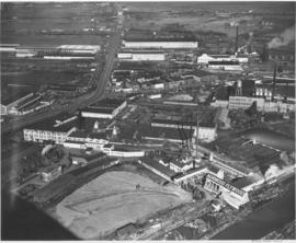
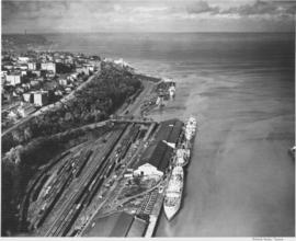
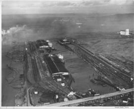
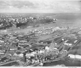
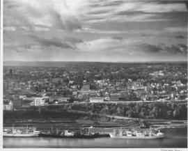
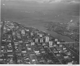
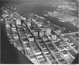
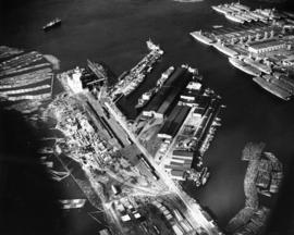
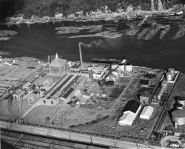
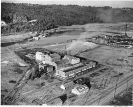
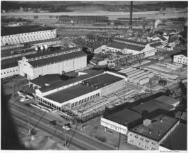
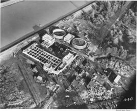
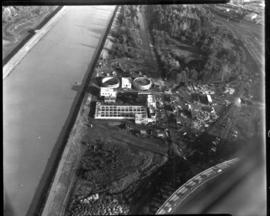
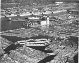
Log boom after log boom filled the Sitcum Waterway and extended out into Commencement Bay in this aerial view of Tacoma's industrial tideflats taken in October of 1948. The grain elevators at the Port of Tacoma stand tall in the center with the Time Oil storage tanks to their left, and the Port Piers just beyond. Over a dozen baby flat top aircraft carriers used in World War II are docked along Wapato Waterway (Port Industrial Waterway). Beyond them (upper left) is the Hooker Electrochemical Plant. The Washington Cooperative Farmers elevators (top center right) are in front of the white cliffs near the top of the photograph. (T.Times, 11/9/1949, p.18)


Aerial views; Port of Tacoma (Tacoma)--1940-1950; Aircraft carriers--Tacoma--1940-1950; Harbors--Tacoma--1940-1950; Industrial facilities--Tacoma--1940-1950; Grain elevators--Tacoma; Logs;

D35790-7

Aerial views: Port Piers, Washington Co-op, grain storage tanks at Port of Tacoma, Norwood Plywood, City Center. Studio, Bob. An aerial view of the Tacoma tideflats looking east. East 11th Street comes from the left and curves northeast across the St. Paul Waterway. St. Paul Avenue starts at East 11th Street and moves southeast towards the Puyallup River. The Wheeler-Osgood Company (at 1216 St. Paul Avenue) is seen in the center, right section. Northwest Door (1203 East D Street) is at the corner of East 11th and East D (center left). Norwood Plywood is believed to be the plywood facility for Northwest Door who began their plywood operations in 1936. The spider-like pipes running from a central location to several buildings is part of Wheeler-Osgood. The corner lot (center front) has been vacant since at least 1938.


Aerial views; Industrial facilities--Tacoma--1940-1950; Wheeler, Osgood Co. (Tacoma); Northwest Door Co., Inc. (Tacoma);

D35933-1

Port of Tacoma aerials. A view of St. Regis and the nearly completed kraft paper plant seen in the foreground. The company is located along the Puyallup Waterway on the Tacoma tideflats.


Aerial photographs; Progress photographs; St. Regis Paper Co. (Tacoma)--1940-1950; Paper industry--Tacoma--1940-1950;

D35933-11

1948 Aerial photographs. A view of the business district of Tacoma to the Tacoma tideflats, Commencement Bay and Brown's Point as the bay joins Puget Sound. The smokestack with the most white smoke is at the St. Regis Paper Company.


Aerial photographs; Cityscapes; Commencement Bay (Wash.); St. Regis Paper Co. (Tacoma)--1940-1950;

D35933-13

Aerial photographs. Shaffer Terminals had two locations, one along the Tacoma waterfront at the foot of Division Avenue and the other on the Tacoma tideflats along the Milwaukee Waterway. This view shows ships tied along the facilities at Milwaukee Waterway and Chicago, Milwaukee and St. Paul Railway Terminal is across the waterway.


Aerial photographs; Shaffer Terminals, Inc. (Tacoma); Marine terminals--Tacoma;

D35933-19

This aerial photograph shows the Tacoma shoreline looking north from the mouth of the City Waterway (Thea Foss Waterway) as it looked in October of 1948. Ships are taking on cargo at the terminals along Dock Street and the Shaffer Terminals on Bay Side Drive along the waterfront at the foot of Division Avenue. Boxcars fill the tracks in the Northern Pacific "half-moon yard". The Fourth Street Bridge provides access over the railroad tracks from Dock St. to Bay Side Drive. The smokestack in the distance is from the ASARCO facilities. This area was dramatically transformed with the building of I-705 and the Schuster Parkway.


Aerial photographs; Shaffer Terminals, Inc. (Tacoma); Marine terminals--Tacoma; Smokestacks--Tacoma;

D35933-21

Aerial photographs. This view shows ships tied along the Shaffer Terminal facilities at Milwaukee Waterway.The Chicago, Milwaukee and St. Paul Railway Terminal is across the waterway on the east. East 11th Street crosses the bottom of the photograph. Log booms have been tied up along the left side (part of the Puyallup Waterway). The Port of Tacoma elevators are on the right. Freighters are seen in Commencement Bay awaiting space to tie up. Browns Point is across the bay before it enters Puget Sound.


Aerial photographs; Shaffer Terminals, Inc. (Tacoma); Marine terminals--Tacoma;

D35933-27

Aerial photographs. A view of Tacoma from the industrial tideflats. The ASARCO stack is in the background. In the immediate foreground is the St. Paul & Tacoma Lumber Company with its many buildings, stacks and scrap burner. East 11th Street comes in from the left and runs across to the right. St. Paul Avenue starts at East 11th Street and takes off to the bottom left corner. The St. Paul & Tacoma Lumber Company is sprawled on both sides of East 11th Street and they had a dock at the end of the land between Middle Waterway and St. Paul Waterway (center,far right). City Waterway is next to Tacoma


Aerial photographs; St. Paul & Tacoma Lumber Co. (Tacoma); Cityscapes; Lumber industry--Tacoma--1940-1950; Smokestacks--Tacoma;

D35933-29

This aerial view of Tacoma looking west was taken in October of 1948. Several ships are docked at the Shaffer Terminals in the immediate foreground. The railroad tracks run along the lower shore with the railroad bridge clearly visible. The commercial district of Tacoma is seen to the left on higher ground. The tall building with a tower near the middle left is the Pierce County Courthouse at 1014 South G Street. Other discernable structures include the Tacoma Elks Temple at left foreground and in the distance to the right, the Tacoma General Hospital complex. The residential areas of the city spread out in the background.


Aerial photographs; Cityscapes; Tacoma General Hospital (Tacoma); Pierce County Courthouse (Tacoma); Benevolent and Protective Order of Elks, Tacoma Lodge No. 174 (Tacoma); Piers & wharves--Tacoma--1940-1950; Bridges--Tacoma;

D35933-7

Aerial photographs. This is a view, taken in October of 1948, of the downtown business district of Tacoma, the 11th Street Bridge to the Tacoma tideflats, Commencement Bay and Brown's Point as the bay joins Puget Sound. Vashon Island is in the distance.


Aerial photographs; Cityscapes; Commencement Bay (Wash.); Business districts--Tacoma--1940-1950;

D36257-1

Aerial views of city. This view of downtown is looking north with the high-rise office buildings shown climbing the hill to the west. The 11st Street Bridge crosses the City Waterway on the far right with the industrial Tacoma tideflats on the other side. The Puyallup River enters into Commencement Bay and has left a noticeable line where the fresh water meets the salt. Several ships are docked at Shaffer Terminals lying on the west side of the City Waterway.


Aerial photographs; Cityscapes; Bays--Washington (State); Commencement Bay (Wash.); City Waterway (Tacoma); Rivers--Washington (State); Puyallup River (Wash.); 11th Street Bridge (Tacoma);

D36257-5

This aerial view of the Port Industrial Waterway shows the Port of Tacoma facilities north of 11th Street as they appeared in 1948. At the far north end is the Port's grain elevator with a capacity of 2-million bushels. Log booms can be seen in both the Sitcum Waterway, on the left, and in the Port Industrial Waterway, bottom right. The U.S. Naval Station is at the upper right with a flotilla of over 15 moth-balled baby flat top aircraft carriers at dock. TPL-3684


Aerial photographs; Bays--Washington (State); Commencement Bay (Wash.); Port of Tacoma (Tacoma)--1940-1950; United States Naval Station (Tacoma); Logs;

D36257-8

This aerial photograph from November 1948 shows the Hooker Electrochemical Company located at 605 Alexander Avenue on the Tacoma tideflats. The waterway above the plant, dotted with log booms, is the Hylebos Waterway. Small houses and businesses line the shore on the other side of the waterway along Marine View Drive. Hooker changed its name to Occidental Chemical Co. in 1982. In 1997 the company was purchased by Pioneer Companies Inc.; the plant closed in 2002. TPL-7977


Aerial photographs; Hooker Electrochemical Co. (Tacoma); Chemical industry--Tacoma--1940-1950; Logs; Hylebos Waterway (Tacoma); Harbors--Tacoma; Factories--Tacoma--1940-1950;

D37578-7

In 1948 College of Puget Sound had the Memorial Fieldhouse built, this building was dedicated in 1949 to those CPS students who died while serving in World War II. In 1949 the President's Residence would be constructed; Dugan, Mock and Morrison were the architects. Aerial view of the College of Puget Sound, Union Avenue and main administration building, in center of photograph.


Education--Tacoma; Streets--Tacoma; Universities & colleges--Tacoma; Aerial photographs; Aerial views; College of Puget Sound (Tacoma)--Buildings;

D43302-1

Aerial of Seattle skyline taken from above Elliott Bay. Piers jut into the bay with warehouses on them. Smith Tower is the taller building on the right. TPL-4749


Aerial photographs; Cityscapes; Skyscrapers--Seattle; Piers & wharves--Seattle; Harbors--Seattle; Smith Tower (Seattle);

D43866-15

Studio stock negatives. An aerial photograph of a rural area with a highway running across it. A woods and lake are seen on the lower half while several buildings around a cleared area are seen above.


Aerial photographs; Land;

D43866-22

Studio stock negatives. An aerial view of rural Pierce County with open and wooded areas. Small groupings of buildings are dotted over the area. Mount Rainier is seen above the mist.


Aerial photographs; Land; Rainier, Mount (Wash.);

D43866-25

Studio stock negatives. An aerial view of residential neighborhoods in Pierce County. New housing developments with no or few trees are in the foreground.


Aerial photographs; Land; Land use--Tacoma--1940-1950; Housing developments--Tacoma--1940-1950;

D43866-26

Studio stock negatives. Aerial view of new housing tract development.


Aerial photographs; Land; Land use--Tacoma--1940-1950; Housing developments--Tacoma--1940-1950;

D50606-2

An aerial view of the Feltrok Insulation Manufacturing Company taken at 7 p.m. June 9, 1950. The company was located on the Tacoma tideflats. Pennsylvania Salt Manufacturing Company is seen on the right. Feltrok was purchased by the American Rock Wool Corporation in 1952. About 35 persons were employed in the Tacoma operation at that time. (Tacoma Reporter, 7/21/1952, p.3)


Aerial photographs; Feltrok Insulation Manufacturing Co. (Tacoma); Industrial facilities--Tacoma--1950-1960; Pennsylvania Salt Manufacturing Co. of Washington (Tacoma);

D50612-1

An aerial view of St. Paul and Tacoma Lumber Company. Colonel Chauncey Griggs, Addison Foster, Henry Hewitt, Jr. and Charles Hebard Jones purchased 83,000 acres of timber in 1888 from the Northern Pacific Raillroad company in the largest purchase of timberland in the nineteenth century. Then they built a giant sawmill on "The Boot", a low island off the main tideflats, bordered by branches of the Puyallup River and Commencement Bay. They built the first standard-guage logging railroad and introduced the band-saw to Pacific Northwest lumber operations. They built the St. Paul & Tacoma Lumber Company. (The Mill on the Boot, Murray Morgan)


Aerial photographs; Lumber industry--Tacoma--1950-1960; St. Paul & Tacoma Lumber Co. (Tacoma);

D53468-35

Scenic views from Eastern Washington. An aerial view of the housing area across the Columbia River from the utility facilities at Grand Coulee Dam. Mason City was built on one side of the river during the dam construction and Engineer's Town grew on the opposite side. This view shows the land forms above the river into the distance.


Columbia River (Wash.); Land; City & town life;

D53468-8

Scenic views from Eastern Washington. An aerial view of farm land, a sprawling building in the center, a plant in the upper right with what may be a Ralston Purina logo painted on a tower, and a small residential community in the upper left in one of the broad valleys of eastern Washington. A narrow river meanders through the foreground.


Land; Valleys--Washington; Rivers; Industrial facilities;

D58919-1

An aerial photograph of the Northgate shopping area. The building in the center of this June, 1951, photograph contains Larson's Department Store and Ridgecrest Super Market. Ordered by Phares Advertising. The area is mixed use with single-family residential areas near this commercial area.


Aerial photographs; Shopping centers--Seattle; Land use--Seattle--1950-1960; Real estate development--Seattle--1950-1960;

D61250-1

Aerial view of sewage disposal plant. Progress photograph of the new sewage disposal plant on Cleveland Way was taken by air on October 3, 1951. Construction continues on the new plant near the Puyallup River under the direction of Hoagland-Findlay Engineering Company who had the low bid of nearly $1,400,000. The two large circular structures are digesting tanks where raw sewage would be digested and eventually turned into fertilizer. Rectangular building appears to be a 14,000,000 gallon sedimentation tank. Photograph commissioned by Hoagland-Findlay. TPL-8824


Aerial photographs; Progress photographs; Building construction--Tacoma--1950-1960; Sewerage--Tacoma; Waste disposal facilities--Tacoma; Hoagland-Findlay Engineering Co. (Seattle);

D61250-2

Aerial photograph of sewage disposal plant. Progress was being made in the construction of a new waste disposal facility on Cleveland Way near the Puyallup River in October, 1951. Aerial view of plant; large circular structures are digesting tanks, square building between them the digestion control building. Raw sludge would be processed in the digesting tanks where ultimately it would be filtered, peeled off in cakes, and then hauled away for fertilizer. According to a 12/12/51 article in the News Tribune, the plant was designed to handle 27 million gallons of sewage a day. Photograph commissioned by Hoagland-Findlay. TPL-8825


Aerial photographs; Progress photographs; Building construction--Tacoma--1950-1960; Sewerage--Tacoma; Waste disposal facilities--Tacoma; Hoagland-Findlay Engineering Co. (Seattle);

D61250-3

Aerial view of sewage disposal plant. Hoagland and Findlay. Sewage treatment plan under construction. Wide canal on left.

D67903-2

ca. 1952. Aerial photograph of residential area, most probably Mountlake Terrace. Mountlake Terrace was an expanding area north of Seattle, in Snohomish County, just north of the King county line. The largely residential area served as a bedroom community for Seattle workers. The area surrounding is still heavily forested and undeveloped. The streets are laid out in curves, forming cul de sacs.


Aerial photographs; Housing developments--Mountlake Terrace;

D67903-4

ca. 1952. Aerial photograph of residential area, most probably Mountlake Terrace, circa 1952. Mountlake Terrace was an expanding area north of Seattle, in Snohomish County, just north of the King county line. The largely residential area served as a bedroom community for Seattle workers. The area surrounding is still heavily forested and undeveloped. The streets are laid out in curves, forming cul de sacs.


Aerial photographs; Housing developments--Mountlake Terrace;

D67903-9

ca. 1952. Aerial view of Northern King County, north of Seattle and west of Lake Washington. The large building on the left with the marquee is most probably the Crest Movie Cinema, located at 16505 5th Ave. NE, Seattle. The homes here appear to mid sized and are located on large lots. The streets are laid out on a square block formation. There are still large sections of woods in view.


Aerial photographs; Aerial views; Housing developments--Seattle; Neighborhoods--Seatte;

Results 721 to 750 of 824