Aerial Photography

Taxonomy

Code

Scope note(s)

Source note(s)

Display note(s)

Hierarchical terms

Aerial Photography

Equivalent terms

Aerial Photography

Associated terms

Aerial Photography

824 Collections results for Aerial Photography

824 results directly related Exclude narrower terms

D163162-15

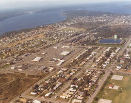
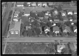
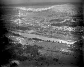
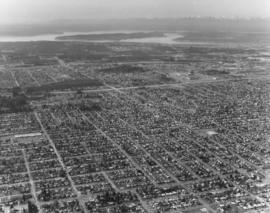
Looking west from South 56th & Pacific Ave. Aerial view on April 2, 1973, of the densely populated area around the Tacoma Mall. The Mall itself is right-center. Olympics are at the top of the photograph. Photograph ordered by Puget Sound National Bank.


Aerial views; Neighborhoods--Tacoma--1970-1980; Tacoma Mall Shopping Center (Tacoma); Shopping centers--Tacoma--1970-1980;

D163000-326C

ca. 1973. 1973 Richards stock footage. This aerial view features the two large domes leased by Kaiser Aluminum from the Port of Tacoma. The aluminum sheathed domes stored shipments of alumina ore from Australia. Both domes were eventually dismantled about 2005.


Aerial views; Storage tanks--Tacoma; Kaiser Aluminum & Chemical Corp. (Tacoma); Port of Tacoma (Tacoma);

D169084-2C

Aerial view of unidentified buildings. Construction may not yet be completed at this unidentified site near a heavily wooded area. There is a large section of cleared land near the two-lane roadways which may later be used for either homes or businesses. Color photograph ordered by Pacific Lanes.


Aerial views; Aerial photographs; Buildings;

D168104-9C

Series of aerials around the vicinity of South 19th & Pearl Sts. taken on behalf of Mueller Investment Co. on October 3, 1977. This view is believed to be a bit further north, near the Westgate Shopping Center and the North End water tower and reservoir.


Aerial photographs; Aerial views; Water towers--Tacoma; Reservoirs--Tacoma;

BOWEN TPL-7012

ca. 1941. Circa 1941 aerial view of the business district of Tacoma at night clearly showing the buildings on Pacific Ave. between 9th and 11th on the east side of the street. Buildings shown include: the Anderson building (1001-05 Pacific), the Bank of California (1011-1013 Pacific), and the Washington Building (1019 Pacific). There is a large neon sign for Mobil Gas on top of the Washington Building.

BOWEN TPL-7624

ca. 1935. This is an aerial view of South 43rd and "L" Sts. circa 1935. South "L" runs horizontally in front of the Engine House No. 8 (4301 South "L"). The fire station was built in 1909, replacing the original which had moved to 4102 South "M." Neighboring lots appear small with many trees. BU-2125

BOWEN TPL-672

ca. 1929. Head of Commencement Bay while Sullivan Service at 101 Puyallup Ave. (lower left) was under construction. This aerial view was taken circa 1929. Visible landmarks and streets included: the Union Station at upper left corner; Albers Bros. Milling Co. at upper center (large darker building) ; Northwest Woodenware Co. at center along waterway; Wheeler-Osgood Co.'s saw mill at right center. The Sullivan Service was being built at this time facing Puyallup Ave. at left. Puyallup Ave., which runs horizontally left to right, also had the Independent Paper Stock Co. kitty-corner from Sullivan's at 132 Puyallup Ave. The Washington Gas & Electric Co. was also on the same side of Puyallup Ave. as the Independent Paper Stock Co., at 212-216, and was the large building near right. The street at lower bottom running left to right is South 25th St. E. (photograph torn at left corner)

BOWEN TPL-6247

ca. 1928. A Street at So. 11th St., looking north, in 1928. The Tacoma Building, at right center, was completed in 1911. The building was home to the Weyerhaeuser Timber Co. and the Tacoma Commercial Club. It is currently being restored. The Tacoma Hotel can be seen in the background, located where the Frank Russell Co. building stands today.

BOWEN TPL-016

ca. 1928. Elevated view of 1300 block of Pacific Avenue circa 1928. Among the many businesses on Pacific Avenue were the Owl Cafe at 1336 Pacific (lower left) and the Dillion Bldg at 1330-32 Pacific. The familiar spire of the Puget Sound National Bank is to the far right. The Pierce County Courthouse looms in the distance at far left back with the big white walled Greenwich Coliseum (407 So. 13th St.) below. The Greenwich Coliseum had opened in 1927 and would become a premier athletic venue and ballroom.

BOWEN BGN-177

This print from a damaged glass plate negative shows an aerial view of South Tacoma taken in February of 1927. The massive South Tacoma Shops, owned by the Northern Pacific Railway, are located in the center. The plant repaired all Northern Pacific railroad locomotives and cars west of the Mississippi. The shops were composed of 36 separate brick buildings spread out over 15 acres. The grounds were over 1 1/2 miles long, and the work force of 1,250 employees from 20 expert crafts commanded a payroll of $1,500,000 per year. Established in 1890 as Edison Car Shops, the shops closed in 1974. The body of water in the foreground just west of the "shops" was a wetlands area affectionately known to residents of the area as the "South Tacoma Swamp." The road at the right, near the south end of the swamp, is 56th Street. (TNT 02/18/1927, pg. 2)

BOWEN BGN-176

Aerial view taken in February of 1926 of the Northern Pacific shops in South Tacoma. Known as the "South Tacoma Shops," the plant was composed of 36 separate brick buildings, covering 15 acres. Craftsmen from 20 expert fields were employed to build, rebuild and service anything that travelled on wheels for Northern Pacific west of the Mississippi. The plant operated from 1890 until its closure in 1974. The body of water to the left was a wetlands area commonly called the "South Tacoma Swamp." It has since been filled in. (TNT 2/18/1927, pg. 2)

Results 811 to 824 of 824