Aerial Photography

Taxonomy

Code

Scope note(s)

Source note(s)

Display note(s)

Hierarchical terms

Aerial Photography

Equivalent terms

Aerial Photography

Associated terms

Aerial Photography

824 Collections results for Aerial Photography

824 results directly related Exclude narrower terms

A118700-19

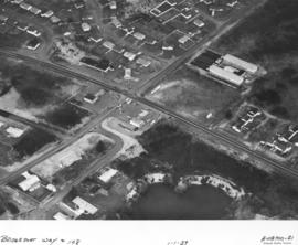
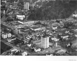
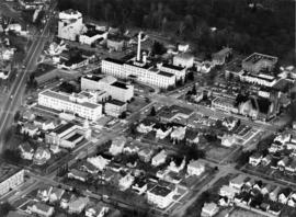
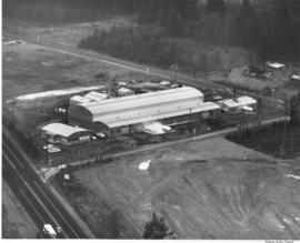
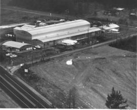
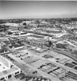
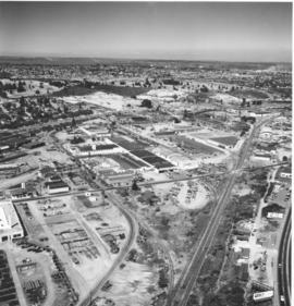
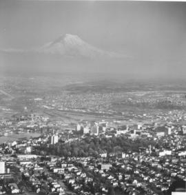
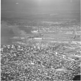
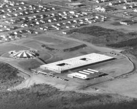
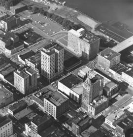
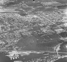
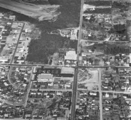
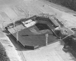
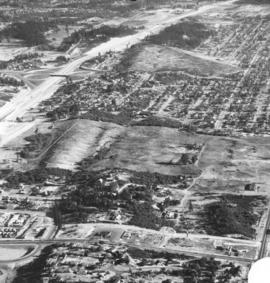
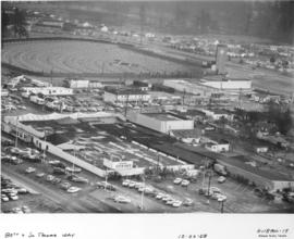
This aerial photographs of the area around South 80th & South Tacoma Way, close to Tacoma's city limits, was taken in December of 1958. Before I-5 was built, South Tacoma Way was part of highway 99. It was a major thoroughfare and businesses located along it had excellent exposure to traffic. South Tacoma Way was known for its many car lots and for such attractions as the B & I shopping center and the Star-Lite Drive-In, both pictured above. The Star-Lite, built in 1948, was one of the world's largest outdoor theaters. It was built with a 39 by 54 foot screen with over three acres of parking. The B&I was originally built in 1946 and as it grew over time it became known as the "biggest little store in the world." Owner E.L. Irwin advertised heavily and was instrumental in bringing celebrities such as Duncan Renaldo ("The Cisco Kid") and boxers Max Baer and Joe Louis to town.


Aerial photographs; Neighborhoods--Tacoma--1950-1960; Star-Lite Park In Theatre (Tacoma); B&I Circus Store (Tacoma);

A118700-21

The Richards Studio worked even on New Year's Day as they took some aerial photographs of the 108th St. and Bridgeport Way S.W. area. Ellie's Shell Service was located at 10808 Bridgeport Way S.W. It appears to have had six pumps and a garage. Behind Ellie's was a brushy area with a flooded gravel pit. This was a growing area and there were many homes and apartment units scattered along these streets. There appeared to be still more room for expansion.


Aerial photographs; Neighborhoods--Lakewood--1950-1960; Ellie's Shell Service (Lakewood);

A118700-23

This aerial photograph shows the original cloverleaf interchange at I-5 and 512 when it was under construction in January, 1959. The road cutting through from left to right is Hwy 99 right at the point where it changes from South Tacoma Way to being Pacific Hwy. SW. The houses at the bottom are part of the Southgate housing development. Southgate was a newer suburban park developed by Tacoma Master Builder Sherman Rowland which lay west of Hwy. 99. Plans were to build 300+ private homes in a park-like setting.


Aerial photographs; Neighborhoods--Lakewood--1950-1960; Housing developments--Lakewood--1950-1960; Express highways--Lakewood;

A118700-26

Aerial photographs were taken on New Year's Day, 1959, of the South End neighborhood in the vicinity of South 56th & Park Ave. This is 56th St. east of the new freeway which would carve out a section of the busy street. This area was already quite settled in the late 1950's. A new Safeway store would be built on South 56th St. just beyond Park Ave. to replace the Safeway on So. 54th & Sheridan, just off 56th St. The Moore branch of the Tacoma Public Library, on 56th close to Pacific Avenue and not visible in this photograph, would be completely rebuilt in 1988. Bethany Methodist Church and Clubhouse, the imposing buildings on Park near the top of the photograph, are still there. Traffic has increased substantially since 1959 on South 56th St.


Aerial photographs; Neighborhoods--Tacoma--1950-1960;

A118700-4

Aerials of the downtown area around Saint Helens, Tacoma Ave. So., and Division were taken by Richards Studio on December 22, 1958, for a sample book. Saint Helens Ave. and Tacoma Ave. So. meet at a "V" at Division. First Presbyterian Church can clearly be seen to the right. The new County-City Bldg. and Central Schools are on Tacoma Ave. on the right side of the photograph. The Medical Arts Bldg. is toward the top center on Saint Helens in a smaller "v". The street to the left of Saint Helens is Broadway. The last street to the left is no longer there; Schuster Parkway has taken its place. Further to the top left corner of the photograph, Puget Sound National Bank and Schoenfeld's furniture store are located. TPL-9298


Aerial photographs; Commercial streets--Tacoma--1950-1960; First Presbyterian Church (Tacoma); County-City Building (Tacoma); Medical Arts Building (Tacoma);

A118700-5

Stadium District aerials were taken by Richards Studio on December 22, 1958, for inclusion in a sample book. To the far left corner is a glimpse of Stadium Bowl. The high school is not visible in this picture. Division and Tacoma Ave. are toward the upper left with the heavily wooded area Wright Park. First Presbyterian Church is on Tacoma Ave. So.; the large white building next to it is the Scottish Rite Cathedral at 5 S G St.


Aerial photographs; Neighborhoods--Tacoma--1950-1960; First Presbyterian Church (Tacoma);

A118700-8

Mary Bridge-Tacoma General Hospital off Division. Aerial photographs of the So. "K" (now Martin Luther King, Jr. Way) and So. "L" Streets were taken just prior to Christmas, 1958. Division Avenue is the street to the extreme left. Tacoma General Hospital, located in the 300 block of So. "K", is the multi-storied white building with dark roof and smokestack. First Christian Church in the 500 block of So. "K" is to the right of the picture. Mary Bridge Children's Hospital is directly in front of Tacoma General in the 300 block of So. "L;" it was dedicated in March, 1955. Wright Park is the wooded area to the top of the photograph.


Aerial photographs; Wright Park (Tacoma); Mary Bridge Childrens Hospital (Tacoma); Tacoma General Hospital (Tacoma);

A119163-6

For several years the Huntington Rubber Mills in Seattle had their plant annually photographed from the air. This is believed to the be plant located at 34315 - 16th South. At that time the area was still relatively open for expansion; there are large sections of trees and an enormous dirt or gravel pit. The plant was situated on a plot of land between two roadways. The long buildings with the semi-curved roofs are probably the plant itself; the smaller building with extended roof the office. There were other assorted smaller units clustered around the plant. Photograph ordered by Huntington Rubber Mills.


Aerial photographs; Huntington Rubber Mills (Seattle);

A119163-7

Closer view by air of the Seattle Huntington Rubber Mills plant. The elongated loaf-shaped buildings with dark stripes painted on the roofs were the Seattle plant of Huntington Rubber Mills. The plant was located at 34315 - 16th South, between two roadways. This area was still relatively sparsely populated in the late 1950's; there would probably have been more room for plant expansion if necessary. A large dirt or gravel pit is next door to the plant with forests to the rear. Photograph ordered by Huntington Rubber Mills.


Aerial photographs; Huntington Rubber Mills (Seattle);

A120358-48

ca. 1959. Aerial of "Nalley Valley, " circa 1959. Tacoma Municipal Water Works building in the lower left hand corner. All of the buildings in the center of the picture, to the left of the railroad tracks, belong to Marcus Nalley's vast food production empire. Nalley's was founded in Tacoma in 1918 and grew rapidly due to the quality of their products. By 1959, their food production was centered in "Nalley Valley" where they produced potato chips, pickles and salad dressing, just to name a few products.


Nalley Valley (Tacoma); Nalley's, Inc. (Tacoma); Food--Tacoma--1950-1960; Food industry--Tacoma--1950-1960; Aerial photographs;

A120358-49

ca. 1959. Circa 1959 aerial of "Nalley Valley." All of the buildings in the center of the picture, to the left of the railroad tracks and above 35th Street which bisects the picture, belong to Marcus Nalley's vast food production empire. Marcus Nalley arrived in Ellis Island in 1903 at the age of 13 with 15 cents in his pocket. By the age of 21, with hard work and perseverance, he was working as a chef at one of Chicago's finest hotels. When he came to Tacoma, he brought with him a recipe for an Eastern delicacy "Saratoga Chips"- potato chips. By 1920, he had need of a factory to produce his chips, plus two new products of his design: Lumber Jack Syrup and Nalley's Mayonaise. His first factory opened at 409 Puyallup Ave. He guided his company and employees through the depression. By 1930, he set his sights on a 17 acre parcel on the outskirts of town. By the 1940's, his modern factory opened in that area that became known as "Nalley Valley." Marcus Nalley died in 1962 and his company was sold to the W.R. Grace Co. in 1966. It has changed ownership since that time, but "Nalley Valley" is still an important part of Tacoma's landscape. ("A History of Pierce County, Vol. 1")


Nalley Valley (Tacoma); Nalley's, Inc. (Tacoma); Food--Tacoma--1950-1960; Food industry--Tacoma--1950-1960; Aerial photographs;

A120358-54

ca. 1959. Aerial of Tacoma, circa 1959. The lower portion of the picture shows the landscape covered with a residential blanket of single family homes. The high rise buildings of downtown can be seen left center of the picture with the Tideflats lying beyond. The snow capped peak of Mt. Rainier can be seen looming over the city, rising from a haze.


Aerial photographs; Rainier, Mount (Wash.); Neighborhoods--Tacoma--1950-1960;

A120358-56

ca. 1959. Aerial of Tacoma, circa 1959. The gothic spires of Stadium High School can be seen about mid picture next to the City (Foss) Waterway. The Eleventh Street Bridge can be seen crossing the waterway next to downtown. To the lower left hand portion of the picture is the area where Schuster Parkway and Tacoma's waterfront will be constructed, it is during the fifties an area of graineries and mills. TPL-8689


Aerial photographs--1950-1960; City Waterway (Tacoma); Rainier, Mount (Wash.);

A120358-59

ca. 1959. Aerial of Tacoma, circa 1959. Tacoma's downtown can be seen clearly in the center of the picture. The heavily forested area is Wright Park. The Eleventh Street Bridge crosses over the City (Foss) Waterway leading to the industrial development of the Tideflats. High above the city is the visage of Tacoma's most famous landmark, the white capped peaks of Mt. Rainier. A heavy haze lies over the city, either a weather condition or a visible reminder of the "aroma of Tacoma" air pollution. TPL-9299


Aerial photographs--1950-1960; Cityscapes--1950-1960; Wright Park (Tacoma); Rainier, Mount (Wash.);

A120358-63

ca. 1959. Aerial of Tacoma, looking across downtown to the Tideflats, circa 1959. The City Waterway (now Foss) bisects the picture, crossed by its three bridges. A haze rises from the heavily industrial Tideflats.


Aerial photographs--1950-1960; Cityscapes--1950-1960; City Waterway (Tacoma);

A120358-64

ca. 1959. Circa 1959 aerial of downtown Tacoma. In the upper left center of the picture is the recently completed County-City building at 930 Tacoma Avenue South. To its left is the new (1952) Tacoma Public Library and the adjacent Carnegie library. To the rear of the County-City building, the old Pierce County Courthouse is partially demolished. Behind the County Courthouse is the Armory, which still stands today. To its left is the Tacoma Vocational School (now Bates.)


Aerial photographs--1950-1960; Commercial streets--Tacoma--1950-1960; County-City Building (Tacoma); Tacoma Public Library (Tacoma); State Armory (Tacoma); Pierce County Courthouse (Tacoma);

A120358-76

ca. 1959. Aerial of Hunt Junior High School, opened in 1958 to serve the growing communities of Fircrest and West Tacoma. When completed, the school designed by architect Robert Billsbrough Price was hailed as one of the most imaginative new schools in the country, and one of the least expensive per square foot. The reduced cost was due to the use of wood in construction, as opposed to concrete. The school's most distinctive feature was its mushroom shaped cafeteria/auditorium, growing from the landscape like something from P.T. Barnum. Hunt opened in 1958 with 27 teachers and 700 students under the guidance of Principal Trygve Blix. It was named after Henry F. Hunt, a Tacoma educator for 34 years who died in 1937. The school was expanded in 1964, 1974 and 1980. ("For the Record" by Winnifred L. Olsen) TPL-10159


Henry F. Hunt Junior High School (Tacoma); Public schools--Tacoma--1950-1960; Aerial photographs; Aerial views;

A122601-13

Aerial exposure of Bethlehem Pacific Coast Steel Co. in Seattle, industrial fastener division. Also known as the Bolt and Nut Department, this plant is located on a five acre tract along the Duwamish Waterway less than a mile east of the main plant. Here steel bars and rods are manufactured into bolts, nuts, spikes, rivets and a variety of fasteners.


Steel industry; Bethlehem Pacific Coast Steel Corp. (Seattle); Aerial photographs; Factories--Seattle;

A124027-3

Pioneer Sand and Gravel Co.; aerial view of the gravel pit located at Steilacoom, Wa. The company specialized in sand, gravel, concrete and building materials. TPL-9238


Industry--Steilacoom; Sand--Steilacoom; Digging--Steilacoom; Waterfronts; Harbors--Steilacoom; Sandstone quarrying--Steilacoom; Industrial facilities--Steilacoom; Aerial views; Pioneer Sand & Gravel Co. (Steilacoom);

A125600-22

ca. 1960. Aerial photograph of Hooker Electrochemical plant on Alexander Avenue in the Tideflats ca. 1960 Richards stock footage. Built on the site of the old Foundation shipyard, the Hooker plant opened in February, 1929. It played a leading part in Tacoma's industrial history for over sixty years. Company name was changed without comment to Occidental Chemical Corp. in 1982.


Hooker Electrochemical Co. (Tacoma); Chemical industry--Tacoma--1960-1970; Aerial photographs;

A125600-26

ca. 1960. Aerial photograph of the Pennsylvania Salt Manufacturing Co. in 1960 Richards Studio's stock footage. This Tacoma plant, opened in 1929, covered nearly 40 acres of tideflats on the Hylebos Waterway. A ship is docked ready to transport Pennsalt's chemical products. TPL-6578


Pennsylvania Salt Manufacturing Co. of Washington (Tacoma); Chemical industry--Tacoma--1960-1970; Aerial photographs;

A125600-27

ca. 1960. Pennsylvania Salt Manufacturing Co.'s 40-acre plant faced the Hylebos Waterway and portions of undeveloped Northeast Tacoma, including an enormous gravel pit. Aerial photographs taken by the Richards Studio in 1960 show the large facility along with numerous storage tanks. A ship is docked ready to be loaded with the company's chemical products.


Pennsylvania Salt Manufacturing Co. of Washington (Tacoma); Chemical industry--Tacoma--1960-1970; Aerial photographs;

A125600-29

ca. 1960. Richards stock footage, ca. 1960. Aerial photographs of the bustling Tideflats area show businesses west of the Middle Waterway: Tidewater Oil Co., Puget Sound Plywood, Inc., and the Foss Launch & Tug Co. with several Foss tugboats docked nearby.


Puget Sound Plywood, Inc. (Tacoma); Tidewater Oil Co. (Tacoma); Foss Launch & Tug Co. (Tacoma); Aerial photographs;

A125600-41

ca. 1960. Aerials of downtown Tacoma business district. 1960 Richards stock footage shows the neatly laid out downtown streets of "A" and Pacific Avenue with many towering office buildings. Adjacent to the 11th St. Bridge is the Tacoma Building, housing the Weyerhaeuser Company, and the Perkins Building, early home of the Tacoma Daily Ledger. The Federal Building, containing the Main Post Office, is on "A" St. as well. On Pacific Avenue are the Bank of California, easily recognizable by its Ionic columns, Washington Building, and Puget Sound National Bank. The Rust Building is at 9th & Pacific.


Commercial streets--Tacoma--1960-1970; Aerial photographs;

A125600-42

ca. 1960. Downtown city streets with buildings laid out like Lego blocks in this 1960 aerial photograph taken by the Richards Studio. Primarily focuses on "A" and Pacific Avenue which contained many of the city's banks and corporation headquarters. Visible in the center of the photograph are Peoples department store and the Puget Sound National Bank headquarters. The edge of the Washington Building and the Rust Building can be seen on the left side of the picture. The Federal Building is on 11th & A Street.


Commercial streets--Tacoma--1960-1970; Aerial photographs;

A125600-43

ca. 1960. Aerial photographs of the downtown business district, ca. 1960. The towering narrow structure of the Puget Sound National Bank is a focus point on Pacific Avenue. Peoples' department store is next door. Across the street from Peoples is the Washington Building along with the Bank of California. The Rust Building is also on Pacific, across from the Washington Building. The Tacoma Building, home to the Weyerhaeuser Company, and the Perkins Building, later to become the first home of the University of Washington-Tacoma, are on "A" St., flanking the 11th St. Bridge.


Commercial streets--Tacoma--1960-1970; Aerial photographs; Puget Sound National Bank (Tacoma); Peoples (Tacoma); Washington Building (Tacoma); Rust Building (Tacoma); Tacoma Building (Tacoma); Perkins Building (Tacoma);

A125600-65

ca. 1960. Aerial photograph of the Day Island and University Place community ca. 1960. Day Island at the bottom of the page with the new bridge connecting the island to S. 27th St. Tacoma Airport, a 75-acre facility, is to the extreme left corner.


Aerial photographs; Neighborhoods--University Place--1960-1970;

A125600-69

ca. 1960. Aerial photographs of the growing University Place community ca. 1960 Richards Studio stock footage. Heavily wooded areas indicated that there was still plenty of room for development in U.P. in the early 1960's. Horizontal street in center is Bridgeport Way; vertical highway is S. 27th St. The 75-acre Tacoma Airport is in the upper left corner; it would be sold to the Lundstrom Development Co. in 1970.


Aerial photographs; Neighborhoods--University Place--1960-1970; Streets--University Place;

A126738-2

The newly completed Ben Cheney Stadium stood empty on May 18, 1960 when this aerial photograph was taken. The Tacoma Giants, playing in the Pacific Coast League, were out of town playing the San Diego Padres. The $840,000 Cheney Stadium was completed in just three months, fourteen days. As shown above, the parking lots were not yet paved due to slight sinking but a temporary surface made of sand was being applied. Also planned were bleachers to seat another 650 fans on the left field side of the grandstand. Photograph ordered by Cheney Lumber. (TNT 5-27-60 p. 23) TPL-9727


Aerial photographs; Cheney Stadium (Tacoma);

A127907-2

Aerial photograph of 56th St. interchange taken on August 17, 1960. A portion of Wapato Lake is believed to be in the top left corner. So. 38th St. is road near the bottom. Large mostly undeveloped land in center is believed to be the future location of the Tacoma Mall. Ordered by Tacoma Freeway Mart of Seattle.


Aerial photographs; Express highways--Tacoma--1960-1970;

Results 61 to 90 of 824