Aerial Photography

Taxonomy

Code

Scope note(s)

Source note(s)

Display note(s)

Hierarchical terms

Aerial Photography

Equivalent terms

Aerial Photography

Associated terms

Aerial Photography

824 Collections results for Aerial Photography

824 results directly related Exclude narrower terms

A127907-5

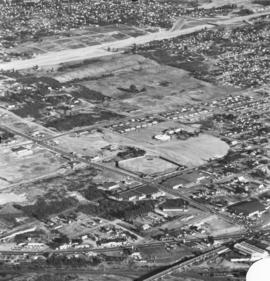
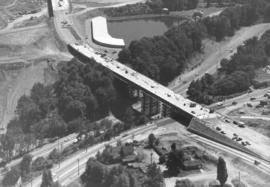
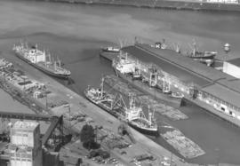
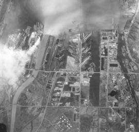
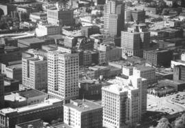
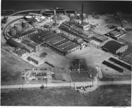
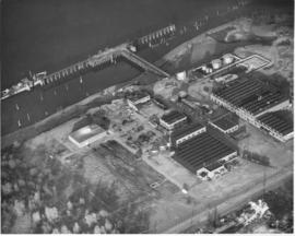
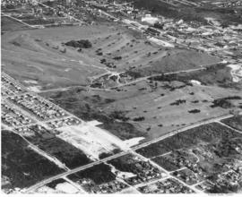
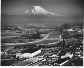
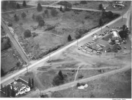
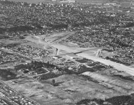
This aerial photograph taken August 17, 1960 shows the I-5 interchange at South 38th Street. The excavation work has begun, and the 38th St. bridge over I-5 is complete. The building to the left of the cloverleaf is Langendorf Bakery, 2202 So. 38th St., which was built in 1954. The large area of cleared land at the bottom of the photograph is the future home of the Tacoma Mall. Part of downtown Tacoma and the tideflats can be seen at the top edge of the picture. Ordered by Tacoma Freeway Mart of Seattle.


Aerial photographs; Express highways--Tacoma--1960-1970;

A127907-7

Aerial photograph of south end area, including 56th St. interchange. Taken on August 17, 1960, on behalf of Tacoma Freeway Mart of Seattle. Baseball field in center is probably old Tiger Field/Cheney Field. Round structure near the baseball field is Madison School. Road traveling diagonally left to right is So. 38th St. intersecting with South Tacoma Way at the bottom.


Aerial photographs; Express highways--Tacoma--1960-1970;

A128445-2

Aerial view of newly completed Pacific Lutheran University administration building taken in early October, 1960. Designed by architects Lea, Pearson & Richards, the two-story U-shaped modern structure was dedicated on October 14, 1960. It had 55,000 square feet of floor space. Initially called the Tacoma-Pierce Administration Building, it was later re-named after Philip E. Hauge, Dean of the University who had spent 45 years with the school. (TNT 10-12-60, C-10)


Aerial photographs; Universities & colleges--Parkland--1960-1970; Pacific Lutheran University (Parkland) --1960-1970;

A128448-3

Aerial view of Annie Wright Seminary and north end neighborhood surrounding the school, taken on October 4, 1960. The private school's tennis courts and playing field are visible with thick forest acting as buffer. Also included is portion of Commencement Bay with large ship docked.


Aerial photographs; Annie Wright Seminary (Tacoma)--1960-1970;

A129800-111

ca. 1961. Stock footage, 1961. Aerial view of Yakima Avenue Bridge under construction in 1961. Northern Pacific railroad tracks below. The $1,300,000 bridge was scheduled to be completed by late spring and opened to traffic in April or May. The Yakima Avenue Bridge would give Tacoma a new route to the city's South End. (TNT 12-11-60, A-1)


Aerial photographs; Bridge construction--Tacoma--1960-1970; Bridges--Tacoma--1960-1970; Yakima Avenue Bridge (Tacoma);

A129800-112

ca. 1961. The $1,300,000 Yakima Avenue Bridge was scheduled to be completed by late April or early May 1961. It was part of Tacoma's six-year capital improvement program which began in 1959. This aerial view of the bridge while under construction clearly shows the Hood Street Reservoir (top center) to the southwest of the bridge, South Tacoma Way (bottom left to top right), and Center Street. (TNT 12-11-60, A-1)


Aerial photographs; Bridge construction--Tacoma--1960-1970; Bridges--Tacoma--1960-1970; Yakima Avenue Bridge (Tacoma); Streets--Tacoma--1960-1970; Reservoirs--Tacoma; Hood Street Reservoir (Tacoma);

A129800-113

ca. 1961. Scenic view and stock footage, 1961. Aerial view of busy Port of Tacoma in 1961on Sitcum and Port Industrial Waterways; building in the center is the port's own grain elevators along with loading dock and storage buildings. The two buildings above the granary are terminals and warehouse #1 belonging to the Chicago, Milwaukee, St. Paul & Pacific RR. Ships are docked waiting to load plywood and other lumber products. Log dumps located nearby.


Aerial photographs; Port of Tacoma (Tacoma);

A129800-156

ca. 1961. Scenic view and stock footage, 1961. Smoke billowing, the American Smelting & Refining Co. (better known as ASARCO)'s smokestack was once the largest smokestack in the world at 571 feet when completed in 1917. Repairs shortened it to 562 feet twenty years later. ASARCO was a major employer in Tacoma for decades; it closed in 1985 due to economic and environmental reasons. The smelter stack was demolished on January 17, 1993.


Aerial photographs; American Smelting & Refining Co. (Tacoma); Smelters--Tacoma--1960-1970; Smokestacks--Tacoma; Industrial facilities--Tacoma;

A129800-158

Traffic was flowing smoothly in this November 1961 aerial photograph of the Tacoma Narrows Bridge. The camera was looking east toward the rapidly developing west end of Tacoma. The graceful lines of the suspension bridge span nearly one-half mile, making it the 5th longest suspension bridge in the US. This was the second Narrows Bridge, dedicated in 1950; the first collapsed in high winds on November 7, 1940, only four months after its dedication. The 1950 bridge was designed to carry 60,000 cars a day. When area population growth increased that number by half, a third bridge was added; parallel to and south of the 1950 bridge. The third Narrows bridge was dedicated in July of 2007 and carries east bound traffic, leaving all lanes of the 1950 bridge open for west bound traffic. (www.wsdot.wa.gov)


Aerial photographs; Tacoma Narrows Bridge (Tacoma); Suspension bridges--Tacoma; Bridges--Tacoma--1960-1970; Neighborhoods--Tacoma--1960-1970;

A131465-1

Aerial photographs taken on June 21, 1961, of the Port of Tacoma show several boats docked, awaiting possible loading of the logs stacked on shore or in log dumps. This particular waterway was not identified. Photograph ordered by Export Pacific, Inc., 900 Milwaukee Waterway.


Aerial photographs; Port of Tacoma (Tacoma); Boats--Tacoma; Logs;

A137300-464

ca. 1963. Aerial view of Tacoma Tideflats industrial area taken in 1963. Floating log dumps in various waterways. Lighter colored waterway to the left is the Puyallup. Smoke billows from one of the many plants, possibly St. Regis. TPL-2247


Aerial photographs; Logs; Puyallup Waterway (Tacoma);

A138537-1

Aerial photograph taken in the spring of 1963 of portion of downtown Pacific Avenue; it features the Bank of California sign recently installed on top of the Washington Building. The Bank of California is the much smaller building adjacent to the Washington Building. It had been situated on Pacific Avenue since 1928. Bank officials confirmed that a move would be made in early 2005 into the historic Waddell Building at 15th & Commerce.


Aerial photographs; Signs (Notices); Bank of California National Association (Tacoma); Washington Building (Tacoma); Commercial streets--Tacoma--1960-1970;

A41825-3

Pennsylvania Salt manufactured the following chemicals: chlorine, caustic soda, sodium hypochlorite, bleaching powder, hydrogen, sodium arsenate, dairy and poultry germicides, special chemical cleaners and laundry and dry cleaning products. Frederick C. Shanaman was the President and General Manager of the company. Aerial view of the Tacoma plant, located at 2901 Taylor Way, in Tacoma's tideflats, near the Turning Basin, which is now known as the Hylebos Basin.


Chemical industry--Tacoma--1940-1950; Chemicals; Industrial facilities--Tacoma; Aerial photographs; Aerial views; Waterfronts; Pennsylvania Salt Manufacturing Co. of Washington (Tacoma);

A41825-5

Aerial view of Pennsylvania Salt Manufacturing Company facilities in Portland, Oregon. President Fred C. Shanaman reported that with the addition of the new facilities for manufacture of chlorine, caustic soda and technical DDT, production at the Portland plant increased substantially in 1947.


Chemical industry--Oregon--Portland; Chemicals; Industrial facilities--Oregon--Portland; Aerial photographs; Aerial views; Waterfronts; Pennsylvania Salt Manufacturing Co. (Portland, Or.);

A43866-27

Studio stock negatives. A view from over Commencement Bay, the Tacoma tideflats with the St. Regis Dock and St. Regis Company with Mount Rainier looming in the distance.


Aerial photographs; Land; Land use--Tacoma--1940-1950; St. Regis Paper Co. (Tacoma)--1940-1950; Rainier, Mount (Wash.);

A43866-30

Studio stock negatives. An aerial view of new housing developments. Uncleared land abruptly abuts the housing development. Across the road in the foreground are a few small homes set on what looks like pasture land.


Aerial photographs; Land; Land use--Tacoma--1940-1950; Housing developments--Tacoma--1940-1950;

A43866-31

Studio stock negatives. An aerial view of new housing developments in Tacoma during the late 1940's.


Aerial photographs; Land; Land use--Tacoma--1940-1950; Housing developments--Tacoma--1940-1950;

A45518-4

This aerial photograph of the Pioneer Sand and Gravel Company gravel pit was taken in November of 1949. The large gravel pit was located in Steilacoom adjacent what is now University Place; their offices were in Seattle, at 901 Fairview Avenue North. The company specialized in sand, gravel, building materials and "Tru-Mix" concrete. Some years later the pit and the land surrounding it became part of Chambers Creek Properties. In June of 2007 the $21 million Chambers Bay Golf Course opened on this site. TPL-10540


Industry--Steilacoom; Sand--Steilacoom; Digging--Steilacoom; Waterfronts; Harbors--Steilacoom; Sandstone quarrying--Steilacoom; Industrial facilities--Steilacoom; Aerial views; Pioneer Sand & Gravel Co. (Steilacoom);

A49811-2

Aerial view of Allenmore Golf Course. The club house is seen in the middle of the large, newly landscaped golf course. The fairways are seen switch back style through the foreground and far background. New housing sub-divisions are seen across So. 19th Street.


Allenmore Golf Club (Tacoma); Golf--Tacoma--1950-1960; Sports & recreation facilities--Tacoma; Aerial photographs; Land use--Tacoma;

A49811-7

An aerial view of Allenmore Golf Course that includes the residential neighborhoods around the golf course. In the background can be seen the taller buildings of the Tacoma business district and beyond that, Commencement Bay.


Allenmore Golf Club (Tacoma); Golf--Tacoma--1950-1960; Sports & recreation facilities--Tacoma; Aerial photographs; Land use--Tacoma;

A50135-3

Scenic view of Mount Rainier beyond the Tacoma tideflats. City Waterway (later renamed Foss Waterway) lies in the foreground with Centennial Flouring Mills on the lower side of it and Uion Oil with their "76" storage tanks, Shell Oil, Northwest Door Company, and Richfield Oil lining the opposite side. The Puyallup River zig-zags into the distance beyond the smokestacks of St. Paul & Tacoma Lumber Company. This photograph was taken using an aerial camera. TPL-9862


Aerial photographs; Rainier, Mount (Wash.); Storage tanks--Tacoma; Tacoma Tideflats (Tacoma); Industrial facilities--Tacoma--1940-1950; Waterfronts--Tacoma;

A52678-1

This aerial view of part of the sprawling St. Paul & Tacoma Lumber Company complex with Mount Rainier in the background dates from September of 1950. St. Paul & Tacoma with its many buildings, smokestacks and burners was located in the southwest section of the Tacoma tideflats near the Puyallup River; their headquarters were at 1220 Saint Paul Avenue. The white bridge near the center of the image crossing the channelized Puyallup River is the Lincoln Avenue bridge. Two railroad bridges and the Pacific Highway (U.S. Hwy 99) bridge can be seen further up the river.


Aerial photographs; St. Paul & Tacoma Lumber Co. (Tacoma); Cityscapes; Lumber industry--Tacoma--1950-1960;

A53023-1

Aerial view shows progress being made on new construction for the St. Regis Paper Company in September, 1950. Established as a company in 1899, St. Regis was open for business in Tacoma in 1928. Rebuilt and modernized in 1936, St. Regis bought additional acreage from the St. Paul Tacoma Lumber Company in 1947 to add a paper mill and multi wall bag plant. According to the St. Regis 1950 annual report, Tacoma's expansion of their pulp mill would enlarge the pulp capacity from 115,000 to 135,000 tons a year. The new capacity will be in production in 1951.


St. Regis Paper Co. (Tacoma)--1950-1960; Paper industry--Tacoma--1950-1960; Factories--Tacoma--1950-1960; Progress photographs--1950-1960; Aerial photographs;

A53024-1

Aerial view, 1000 foot elevation, of Sumner manufacturing division of Fleischmann's Yeast taken in September, 1950. Photograph taken at 5 p.m.; evening shadows start to creep over the large plant. Fleischmann's Yeast was part of Standard Brands, Inc., and is still sold in grocery stores today. Photograph ordered by Standard Brands' New York City office.


Fleischmann's Yeast (Sumner); Standard Brands, Inc. (Sumner); Aerial photographs;

A53173-1

ca. 1950. Aerial view of Annie Wright Seminary, from Tacoma Ave. No. to Commencement Bay in the North end of Tacoma. The heavily wooded area between the school and the Stadium district is Garfield Park. Annie Wright Seminary was endowed by Northern Pacific Railroad's President C. B. Wright, with an original grant of $50,000. The school was named for his daughter Annie. It opened in 1884 with 94 students, at its original location of 611 Division Ave. It was moved to this location in 1924.


Annie Wright Seminary (Tacoma)--1950-1960; Private schools--Tacoma; Aerial photographs; Annie Wright Seminary (Tacoma)--Buildings

A53195-1

ca. 1950. This aerial view was taken probably in the fall of 1950. The Little Church on the Prairie is shown in the left hand corner; Lakewood Community Center is several hundred feet away to the right. Both structures came into existence roughly the same time; the Little Church on the Prairie was converted from a grocery store to a community church in 1938 while Norton Clapp founded the Lakewood Center in 1937, one of the country's first planned shopping centers.


Little Church on the Prairie (Lakewood); Lakewood Community Center (Lakewood); Aerial photographs; Aerial views;

A53195-12

ca. 1950. Aerial view of South Tacoma Way at Steilacoom Blvd. was taken probably in the fall of 1950. This was near South 96th-100th Streets. Although the area is starting to become developed, there is still a lot of vacant land available.


Aerial photographs; Land--Tacoma--1950-1960; Commercial streets--Tacoma--1950-1960;

A53195-13

ca. 1950. Aerial view of Steilacoom Blvd. near South Tacoma Way was taken probably in the fall of 1950. Although houses and businesses dot the landscape, there was still plenty of room for expansion.


Aerial photographs; Commercial streets--Tacoma--1950-1960; Land--Tacoma--1950-1960;

A53195-14

ca. 1950. Aerial view of Mountain View Cemetery on Steilacoom Blvd.; photograph taken probably in the fall of 1950. The Pacific Naval Advance Base, also known as the Lakewood Navy Yard, lies across the street. Mountain View was a very large memorial park; among its facilities included a cemetery, funeral home, chapel, crematorium and mausoleum. According to an advertisement in the 1951 City Directory, a mourner could place complete responsibility in the very capable hands of Mountain View.


Aerial photographs; Mountain View Memorial Park (Lakewood); Pacific Naval Advance Base (Lakewood); Lakewood Navy Yard (Lakewood);

A53195-3

ca. 1950. Aerial view of landscape close to Steilacoom Blvd. was taken probably in the fall of 1950. The area was slowly developing; however, there was still much room for expansion. Developers did manage to leave much of the tall foliage around the homes.


Aerial photographs; Neighborhoods--Lakewood--1950-1960; Land use--Lakewood--1950-1960;

Results 91 to 120 of 824