Aerial Photography

Taxonomy

Code

Scope note(s)

Source note(s)

Display note(s)

Hierarchical terms

Aerial Photography

Equivalent terms

Aerial Photography

Associated terms

Aerial Photography

824 Collections results for Aerial Photography

824 results directly related Exclude narrower terms

D34612-111

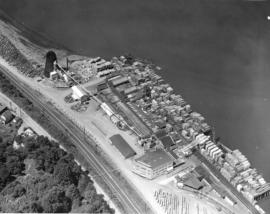
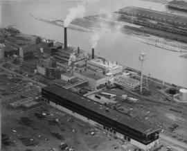
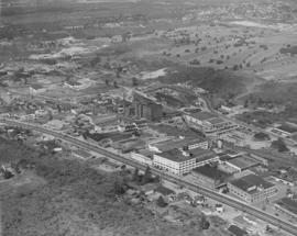
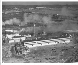
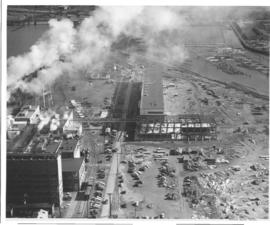
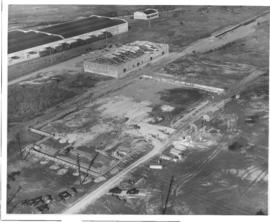
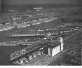
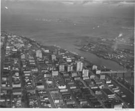
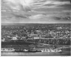
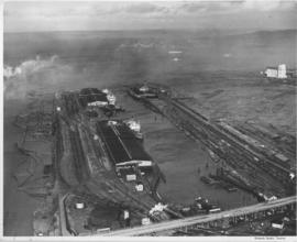
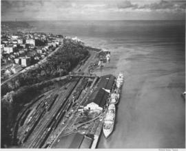
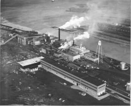
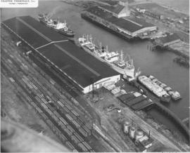
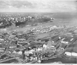
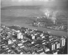
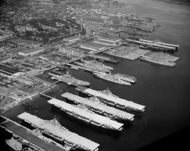
Aerial view of Bremerton Shipyard, also known as Puget Sound Naval Shipyard, in August, 1948, including harbor, aircraft carriers and ships. Established in 1891 as a naval station, the Puget Sound Naval Shipyard originally opened as a repair facility but expanded in WWI to accommodate shipbuilding. During WWII, its primary business was in repairing battle-damaged ships of the US fleet and those of its allies. New construction appeared limited to smaller vessels such as destroyer escorts as the yard performed much work in modifying and upgrading ships. Following WWII, the shipyard was busy modernizing carriers, including conversion of conventional flight decks to angled decks. During the war years, Puget Sound Naval Shipyard had five large drydocks (a sixth was added later) and four new shipbuilding ways for construction of escort vessels. It is located adjacent to the city of Bremerton and covers 327 acres of hard land and 338 acres of submerged land. (www.globalsecurity.org/military/facility/puget_sound-nsy.htm)


Aerial photographs; Naval yards & naval stations--Bremerton; Government vessels--Bremerton; Marine terminals--Bremerton; Puget Sound Naval Shipyard (Bremerton);

D34612-51

Aerial view of Tacoma Lumber Fabricating Co. on Old Town waterfront. This is an August, 1948, view of the Tacoma Lumber Fabricating Co. including stacks of lumber. Tacoma Lumber was situated on the former site of Henry Mill & Timber Co. on No. Starr St. It had taken over the business in August, 1945. Realizing the need for more affordable, quicker construction of new homes after WWII, Tacoma Lumber expanded its structural beam business to include the creation of panels for entire prefabricated houses. By the early 1950's, Tacoma Lumber was gone from No. Starr St., replaced by Pacific Oerlikon Co., manufacturers of electric equipment.


Aerial photographs; Tacoma Lumber Fabricating Co. (Tacoma); Lumber industry--Tacoma--1940-1950;

D34612-24

This was how Tacoma's Stadium district appeared from the air in August of 1948. The First Presbyterian Church at 20 Tacoma Avenue South, marked by its bell tower, lay at the corner of Tacoma Avenue South and Division Avenue. The Big Bear Market (618-20 No. 1st St.) and Walker Chevrolet (633 Division) were in the narrow portion of the pie shaped wedge between Division Avenue and North 1st Street. Stadium High School, 111 No. E St., was in the upper left and the Shaffer Terminals lined Commencement Bay in the background. Photo ordered by Columbia Breweries.


Aerial photographs; Neighborhoods--Tacoma; First Presbyterian Church (Tacoma); Stadium Market (Tacoma); Stadium High School (Tacoma); Shaffer Terminals, Inc. (Tacoma);

D34612-13

This is an aerial view of the Prospect Hill neighborhood which was taken in August of 1948. The photograph mainly focuses on the intersection of East Road and North Road. The large and elegant homes included 91 East Road, 95 East Road (since demolished) and 101 East Road to the left . There is a vacant lot on the right side of East Road and another spacious residence at 102 East Road.


Aerial views; Neighborhoods--Tacoma--1940-1950;

D34612-1

Aerial view of Tacoma's Lincoln High School and Lincoln Bowl; the bowl is expected to be completed by September 1948, photo ordered by Columbia Breweries. TPL-8134


Aerial photographs; Lincoln High School (Tacoma); Lincoln Bowl (Tacoma);

D34612-17

Another view of the Prospect Hill neighborhood by air in August of 1948. The spacious homes are bordered by a large forest. East Road is pictured here curving into North Road. A vacant lot, perhaps being readied for construction, is situated between homes at 74 East Road and 102 East Road. 76 East Road is directly across the street from the empty lot. 14 North Road with covered patio is on the left side of North Road.


Aerial views; Neighborhoods--Tacoma--1940-1950;

D34647-12

South Tacoma was featured in the Tacoma Times Labor Day Industrial pages, the area was rapidly expanding and contributing many new jobs and homes to Tacoma community members. Aerial view of available area, neighborhoods and the Star-Lite Park In Theatre (background), all located along South Tacoma Way (T. Times, 8/31/48, p. 21).


Cities & towns--Tacoma; City & town life--Tacoma; Aerial views; Aerial photographs; Neighborhoods--Tacoma; Drive-in theaters--Tacoma; Star-Lite Park In Theatre (Tacoma); South Tacoma Way (Tacoma);

D34647-15

The Auto-View Theater was located on South Tacoma Way and South 99th Street. At 9915 South Tacoma Way was the Motel Fontaine, at the bottom center in this photograph. Aerial view of available area, neighborhoods and the Auto-View Theater (right side), all located along South Tacoma Way (T. Times, 8/31/48, p. 21).


Cities & towns--Tacoma; City & town life--Tacoma; Aerial views; Aerial photographs; Neighborhoods--Tacoma; Drive-in theaters--Tacoma; Auto-View Theater (Tacoma); South Tacoma Way (Tacoma);

D34647-5

Cooperation between South Tacoma employers and employees have played an important role in the steady growth of this south side community. South Tacoma businesses and industries have helped raise the overall payroll of the city. View of available area, neighborhoods and the Star-Lite Park In Theatre located along South Tacoma Way (T. Times, 8/31/48, p. 21).


Cities & towns--Tacoma; City & town life--Tacoma; Aerial views; Aerial photographs; Neighborhoods--Tacoma; Drive-in theaters--Tacoma; Star-Lite Park In Theatre (Tacoma); South Tacoma Way (Tacoma);

D34647-3

Aerial view of South Tacoma Way and the surrounding community. South Tacoma has been expanding rapidly since the end of World War II with growth in the industrial, business and residential areas. View of neighborhoods and the Star-Lite Park In Theatre located along South Tacoma Way as taken in August of 1948. (T. Times, 8/31/48, p. 21) TPL-9090


Cities & towns--Tacoma; City & town life--Tacoma; Aerial views; Aerial photographs; Neighborhoods--Tacoma; Drive-in theaters--Tacoma; Star-Lite Park In Theatre (Tacoma); South Tacoma Way (Tacoma); Streets--Tacoma--1940-1950;

D34647-1

Aerial view of the Star-Lite Park In Theatre, which opened in May 1948. Tacoma's Star-Lite Theatre was one of the largest outdoor theaters in the world. South Tacoma Way runs through the center of the photo, an athletic field is located on south side of theater (T. Times, 8/31/48, p. 21).


Cities & towns--Tacoma; City & town life--Tacoma; Aerial views; Aerial photographs; Athletic fields--Tacoma; Drive-in theaters--Tacoma; Star-Lite Park In Theatre (Tacoma); South Tacoma Way (Tacoma);

D34647-14

South Tacoma has many new developments, industrial facilities, businesses and new residential neighborhoods. The residential areas are said to be ideally situated between the industries and businesses. Aerial view of available area, neighborhoods and the Star-Lite Park In Theatre (left side), all located along South Tacoma Way (T. Times, 8/31/48, p. 21).


Cities & towns--Tacoma; City & town life--Tacoma; Aerial views; Aerial photographs; Neighborhoods--Tacoma; Drive-in theaters--Tacoma; Star-Lite Park In Theatre (Tacoma); South Tacoma Way (Tacoma);

D34815-12

On August 18, 1948, the Richards Studio photographer flew around the city of Tacoma taking shots of various neighborhoods and individual streets. This aerial view is of S. 15th & Market Sts. near downtown Tacoma. The street running left to right at the bottom is 15th St. The light colored street at center is Market St. The Labor Temple, built circa 1941, is at the corner of 15th & Market (actual address of 1355 Market St.)


Aerial photographs; Aerial views; Neighborhoods--Tacoma--1940-1950; Labor Temple (Tacoma); Streets--Tacoma--1940-1950;

D34815-6

Aerial view, taken in August of 1948, of the large St. Regis Paper Co. plant located in Tacoma's industrial Tideflats. Waterway in center is the Puyallup Waterway. St. Regis was undergoing expansion as depicted by the unfinished building in the foreground. Three years later a big new bag plant would be built, adding to Tacoma's payroll.


Aerial photographs; Aerial views; St. Regis Paper Co. (Tacoma)--1940-1950; Paper industry--Tacoma--1940-1950; Industrial facilities--Tacoma--1940-1950; Building construction--Tacoma--1940-1950; Puyallup Waterway (Tacoma);

D34815-9

This is the neighborhood surrounding the Old St. Joseph Hospital as viewed by air in August of 1948. The hospital is at the upper center of the photograph at 1812 South "I" St. St. Nicholas Greek Orthodox Church, with its dome, is on the right edge of the photograph at 1523 Yakima Ave. So.


Aerial views; Aerial photographs; Neighborhoods--Tacoma--1940-1950; St. Joseph Hospital & School of Nursing (Tacoma); St. Nicholas Greek Orthodox Church (Tacoma); Streets--Tacoma--1940-1950;

D34815-26

The areas around South 15th and South 17th Streets were photographed by air in August of 1948. The Old St. Joseph Hospital (1812 S. "I") is on the left center side of the picture. The ballpark at the upper right hand corner is believed to be Athletic Park (later renamed Peck Field), 1418 S. Sprague.


Aerial views; Aerial photographs; Streets--Tacoma--1940-1950; Neighborhoods--Tacoma--1940-1950; St. Joseph's Hospital & School of Nursing (Tacoma);

D34815-21

Aerial view of Tacoma, George Jacobson. Streets from left to right are South Tacoma Way, (Burlington Northern - Santa Fe Rail Road tracks) Center Street, and 25th Street. The large unimproved property, upper center, is Allenmore Golf Club. A new residential area is just across 19th Street from the golf course. The building in the upper center, left was a furniture factory. TPL-9318


Aerial photographs; Commercial streets--Tacoma--1940-1950; Railroad tracks--Tacoma--1940-1950; Allenmore Golf Club (Tacoma); Golf--Tacoma--1940-1950; Land use--Tacoma--1940-1950; Land--Tacoma--1940-1950; Hills--Tacoma;

D34815-17

This is how the area around South Tacoma Way and Steele St. appeared in aerial photographs taken in August of 1948. Street near photograph's bottom is South Tacoma Way. The uniquely designed Java Jive (then called the Coffee Pot Restaurant) is on the left. Across the street is Lowrie Moving & Storage and the large Northwest Chair Co. plant at 2201 South Tacoma Way. To the left of Northwest Chair is the Johnson's Millwork firm at 2319 South Tacoma Way. At 2629 So. Steele St. is the big F.S. Harmon Mfg. Co. who bought the former Gregory Furniture Mfg. plant in 1945. Harmon's name is clearly labeled on the building's exterior.


Aerial views; Aerial photographs; Java Jive (Tacoma); Coffee Pot Restaurant (Tacoma); F.S. Harmon Manufacturing Co. (Tacoma); Northwest Chair Co. (Tacoma); Johnson's Millwork, Inc. (Tacoma); Lowrie Moving & Storage (Tacoma);

D35471-1

An aerial view looking east across the Tacoma tideflats with St. Regis Paper Company in the foreground. St. Regis was nearing completion of a $6 million addition to their kraft paper plant and adding a multi-wall bag plant. They have been at this location on the tideflats since 1936.


Aerial photographs; St. Regis Paper Co. (Tacoma)--1940-1950; Progress photographs; Paper industry--Tacoma--1940-1950; Lumber industry--Tacoma--1940-1950; Industrial facilities--Tacoma--1940-1950;

D35471-2

Aerial view of new construction in 1948 at St. Regis. St. Regis had an excellent location between the Sitcum Waterway on one side and the Milwaukee Waterway on the other. Below them was Commencement Bay and beyond was more of the Tacoma tideflats. St. Regis was expanding their kraft paper operations and adding a multi-wall bag plant. Logs are seen in Milwaukee Waterway, called the Milwaukee Boom Company dump. Logs were brought in by the railroad and dropped, sorted and made into rafts here. (TNT, 10/17/1948, p.1)


Aerial photographs; St. Regis Paper Co. (Tacoma)--1940-1950; Progress photographs; Paper industry--Tacoma--1940-1950; Industrial facilities--Tacoma--1940-1950; Logs;

D35469-8

Miscellaneous aerials, Port Piers, Schaeffer Terminal, Tacoma Lumber Fabricating Company. An aerial view of an industrial building site in Tacoma. The area has been leveled and forms are in place to begin pouring concrete. This is believed to be the location of the new facilities for Tacoma Drug Company. Another building in the background is nearly finished with the covering being added to the barrel roof.


Aerial photographs; Building construction--Tacoma--1940-1950; Reinforced concrete construction--Tacoma--1940-1950;

D35469-2

Miscellaneous aerials, Port Piers, Schaeffer Terminal, Tacoma Lumber Fabricating Company. A 1948 aerial view of the Port of Tacoma including the Port piers and the grain elevators. Time Oil storage tanks are seen in front of the grain elevators. Baby flattops (smaller aircraft carriers) were mothballed in Tacoma after the end of World War II in the Port Industrial Waterway. TPL-8305


Aerial photographs; Port of Tacoma (Tacoma)--1940-1950; Aircraft carriers--Tacoma--1940-1950; Harbors--Tacoma; Marine terminals--Tacoma--1940-1950; Shipping--Tacoma--1940-1950;

D35933-7

Aerial photographs. This is a view, taken in October of 1948, of the downtown business district of Tacoma, the 11th Street Bridge to the Tacoma tideflats, Commencement Bay and Brown's Point as the bay joins Puget Sound. Vashon Island is in the distance.


Aerial photographs; Cityscapes; Commencement Bay (Wash.); Business districts--Tacoma--1940-1950;

D35933-29

This aerial view of Tacoma looking west was taken in October of 1948. Several ships are docked at the Shaffer Terminals in the immediate foreground. The railroad tracks run along the lower shore with the railroad bridge clearly visible. The commercial district of Tacoma is seen to the left on higher ground. The tall building with a tower near the middle left is the Pierce County Courthouse at 1014 South G Street. Other discernable structures include the Tacoma Elks Temple at left foreground and in the distance to the right, the Tacoma General Hospital complex. The residential areas of the city spread out in the background.


Aerial photographs; Cityscapes; Tacoma General Hospital (Tacoma); Pierce County Courthouse (Tacoma); Benevolent and Protective Order of Elks, Tacoma Lodge No. 174 (Tacoma); Piers & wharves--Tacoma--1940-1950; Bridges--Tacoma;

D35933-21

Aerial photographs. This view shows ships tied along the Shaffer Terminal facilities at Milwaukee Waterway.The Chicago, Milwaukee and St. Paul Railway Terminal is across the waterway on the east. East 11th Street crosses the bottom of the photograph. Log booms have been tied up along the left side (part of the Puyallup Waterway). The Port of Tacoma elevators are on the right. Freighters are seen in Commencement Bay awaiting space to tie up. Browns Point is across the bay before it enters Puget Sound.


Aerial photographs; Shaffer Terminals, Inc. (Tacoma); Marine terminals--Tacoma;

D35933-19

This aerial photograph shows the Tacoma shoreline looking north from the mouth of the City Waterway (Thea Foss Waterway) as it looked in October of 1948. Ships are taking on cargo at the terminals along Dock Street and the Shaffer Terminals on Bay Side Drive along the waterfront at the foot of Division Avenue. Boxcars fill the tracks in the Northern Pacific "half-moon yard". The Fourth Street Bridge provides access over the railroad tracks from Dock St. to Bay Side Drive. The smokestack in the distance is from the ASARCO facilities. This area was dramatically transformed with the building of I-705 and the Schuster Parkway.


Aerial photographs; Shaffer Terminals, Inc. (Tacoma); Marine terminals--Tacoma; Smokestacks--Tacoma;

D35933-1

Port of Tacoma aerials. A view of St. Regis and the nearly completed kraft paper plant seen in the foreground. The company is located along the Puyallup Waterway on the Tacoma tideflats.


Aerial photographs; Progress photographs; St. Regis Paper Co. (Tacoma)--1940-1950; Paper industry--Tacoma--1940-1950;

D35933-13

Aerial photographs. Shaffer Terminals had two locations, one along the Tacoma waterfront at the foot of Division Avenue and the other on the Tacoma tideflats along the Milwaukee Waterway. This view shows ships tied along the facilities at Milwaukee Waterway and Chicago, Milwaukee and St. Paul Railway Terminal is across the waterway.


Aerial photographs; Shaffer Terminals, Inc. (Tacoma); Marine terminals--Tacoma;

D35933-27

Aerial photographs. A view of Tacoma from the industrial tideflats. The ASARCO stack is in the background. In the immediate foreground is the St. Paul & Tacoma Lumber Company with its many buildings, stacks and scrap burner. East 11th Street comes in from the left and runs across to the right. St. Paul Avenue starts at East 11th Street and takes off to the bottom left corner. The St. Paul & Tacoma Lumber Company is sprawled on both sides of East 11th Street and they had a dock at the end of the land between Middle Waterway and St. Paul Waterway (center,far right). City Waterway is next to Tacoma


Aerial photographs; St. Paul & Tacoma Lumber Co. (Tacoma); Cityscapes; Lumber industry--Tacoma--1940-1950; Smokestacks--Tacoma;

D35933-11

1948 Aerial photographs. A view of the business district of Tacoma to the Tacoma tideflats, Commencement Bay and Brown's Point as the bay joins Puget Sound. The smokestack with the most white smoke is at the St. Regis Paper Company.


Aerial photographs; Cityscapes; Commencement Bay (Wash.); St. Regis Paper Co. (Tacoma)--1940-1950;

Results 91 to 120 of 824