Aerial Photography

Taxonomy

Code

Scope note(s)

Source note(s)

Display note(s)

Hierarchical terms

Aerial Photography

Equivalent terms

Aerial Photography

Associated terms

Aerial Photography

824 Collections results for Aerial Photography

824 results directly related Exclude narrower terms

D75943-2

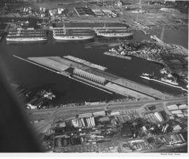
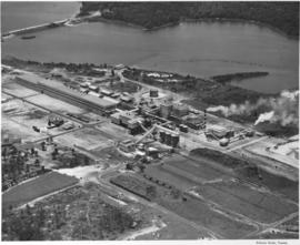
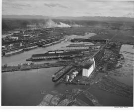
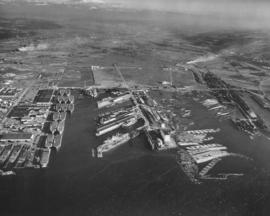
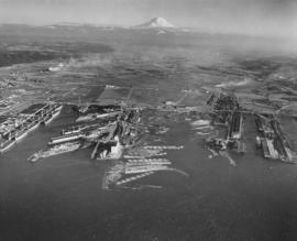
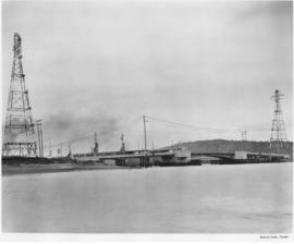
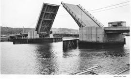
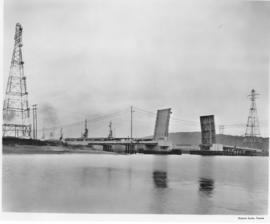
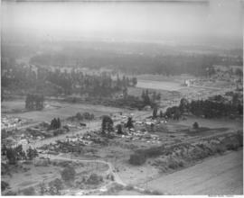
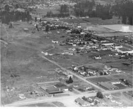
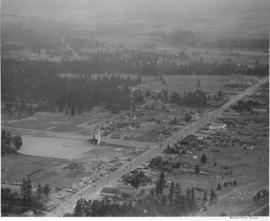
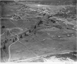
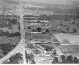
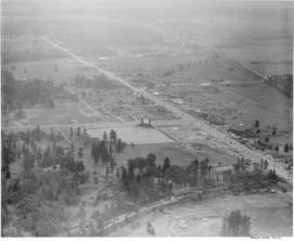
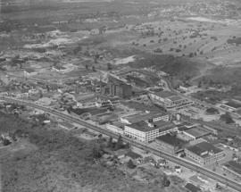
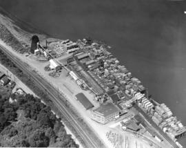
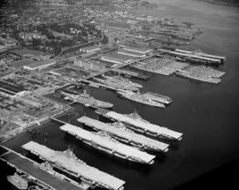
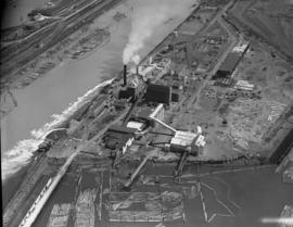
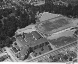
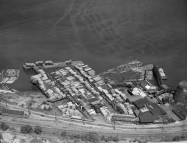
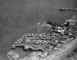
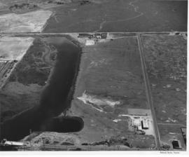
Aerial photographs of the Port of Tacoma at low tide. The body of water is the Port Industrial Waterway, which was being promoted as a future deep water channel. The land lying to the right of the waterway was 1 1/2 miles of industrial land with deepwater access. The road in front of the waterway is East 11th Street, to the right is the Port of Tacoma Road and to the rear is Lincoln Ave. The area behind Lincoln Ave. was scheduled to be filled with the dirt dredged from the waterway and then sold to industries. Stauffer Chemical can be seen on Lincoln Ave. (2545 Lincoln Ave.) The partially completed Port Industrial Waterway bridge can be seen in the foreground of the picture.


Aerial views; Port of Tacoma (Tacoma)--1950-1960;

D75943-23

Baby flat tops built in Tacoma during World War II are "mothballed" along the Port of Tacoma waterfront following the war alongside the Naval Storage area. Hooker Electrochemical Co. lies behind the Naval area (see the circular tanks.) The Port of Tacoma is in the front of the picture with its "finger pier." The partially completed Port Industrial Waterway bridge can be seen on the right hand side next to the flattops. TPL-2253.


Aerial views; Port of Tacoma (Tacoma)--1950-1960;

A74601-4

ca. 1953. Aerial photographs, St. Regis Paper Co. St. Regis had plants in several states, as well as in Canada and South America. This aerial view of the St. Regis plant in Jacksonville, Florida, was taken in 1953. As was the case in most of the company's plants, there was plenty of room for future expansion and water transportation was readily available.


Aerial photographs; St. Regis Paper Co. (Jacksonville, Fl.)--1950-1960; Paper industry--Jacksonville--1950-1960; Industrial facilities--Jacksonville--1950-1960;

D74875-2

Aerial photograph of Sixth Avenue. This aerial photograph of Sixth Avenue near Union shows how the nearby streets are neatly partitioned into grids with well-kept homes and businesses. Near the center of the photograph is the new Tradewell supermarket #30 with its large tower jutting into the sky and expansive parking lot. On the next block a portion of the new Sixth & Washington Square Building can be seen. Photograph ordered by Carl Swanson, Tradewell Stores, Inc.


Aerial photographs; Tradewell Stores, Inc. (Tacoma); Sixth & Washington Square Building (Tacoma);

D81185-9

Aerials of the Port of Tacoma, c. 1954. The Port Industrial Waterway takes up most of the photograph with the mothballed WWII flattops stored in readiness for combat activation next to the U.S. Naval Station. The round storage tanks at Hooker Electrochemical can be seen behind the fleet of ships. The Port of Tacoma fingertip piers lie along the other side of the Waterway. The round storage tanks of Time Oil Co. and the Port of Tacoma Grain Elevators occupy the tip of land jutting out between the Port Industrial Waterway and the Sitcum Waterway. TPL-2250


Aerial views; Port of Tacoma (Tacoma)--1950-1960;

D81185-A

Aerial view of Tacoma industrial Tideflats in 1954 with major focus on the Port Industrial Waterway. Mothballed WWII flattops are positioned close to the U.S. Naval Station. A collection of log booms are amassed in the Sitcum Waterway. The tip of Mount Rainier can be spotted at the top of the photograph.


Aerial photographs; Port of Tacoma (Tacoma)--1950-1960; Sitcum Waterway (Tacoma); Port Industrial Waterway (Tacoma); Logs; Rainier, Mount (Wash.);

D81185-4

Aerials of the Port of Tacoma, circa 1954, with Mount Rainier in the background. From left to right lies the U.S. Naval Station with the mothballed fleet of flattops, kept in readiness, on the Port Industrial Waterway. The fingertip piers of the Port of Tacoma can also be seen on the Industrial Waterway. The Port of Tacoma grain elevators lie at the tip of land facing the Sitcum Waterway. The large, almost rectangular Sitcum Waterway holds many log booms. Tacoma Boat Building's tall sheds for drydock can be seen on the other side of the waterway. The smaller Milwaukee Waterway separates the Henry D. Gee Co. Grain Storage and the Puget Sound Freight Lines. TPL-2255


Aerial views; Port of Tacoma (Tacoma)--1950-1960; Rainier, Mount (Wash.); Port Industrial Waterway (Tacoma); Sitcum Waterway (Tacoma);

A80571-1

Blair Bridge over the Port Industrial Waterway in the closed position, photographs ordered by State Highway Department. The bridge opened in November of 1953. It was a lift bridge structure, a double leaf Bascule span. There was a 150 foot channel between the main piers for the passage of shipping vessels. The bridge was constructed for a cost of $1,600,000. (TNT 11/13/1953, section D)


Port of Tacoma (Tacoma)--1950-1960; Aerial photographs; Harbors--Tacoma; Port Industrial Waterway Bridge (Tacoma); Vertical lift bridges; Bridges--Tacoma; Blair Bridge (Tacoma);

A80571-6

Blair (Port Industrial Waterway) Bridge in the open position, for the State Highway Department. The bridge opened for traffic in November of 1953, cutting commuting time in the Tideflats. It is a lift bridge with a 150 foot channel between the main piers for the passage of shipping vessels. The two main channel piers house the operating machinery for opening and closing the span drawbridge. They are the equivalent in height, measured above and below the water, to a seven story building. (TNT 11/13/1953, Section D)


Port of Tacoma (Tacoma)--1950-1960; Aerial photographs; Harbors--Tacoma; Port Industrial Waterway Bridge (Tacoma); Vertical lift bridges; Bridges--Tacoma; Blair Bridge (Tacoma);

A80571-4

Blair (Port Industrial Waterway) Bridge in open position, for the State Highway Department. Mothballed WWII "Jeep" Carriers in background. The fleet of 25 mothballed escort carriers was kept in combat readiness by the Pacific Reserve Fleet. The bridge opened for traffic in November of 1953. It is a lift bridge, opening for seagoing vessel traffic. The bridge is 712 feet long with a 40 foot roadway and 5 feet of sidewalk on one side only. (TNT 11/13/1953, section D)


Port of Tacoma (Tacoma)--1950-1960; Aerial photographs; Harbors--Tacoma; Port Industrial Waterway Bridge (Tacoma); Vertical lift bridges; Bridges--Tacoma; Blair Bridge (Tacoma);

D34647-3

Aerial view of South Tacoma Way and the surrounding community. South Tacoma has been expanding rapidly since the end of World War II with growth in the industrial, business and residential areas. View of neighborhoods and the Star-Lite Park In Theatre located along South Tacoma Way as taken in August of 1948. (T. Times, 8/31/48, p. 21) TPL-9090


Cities & towns--Tacoma; City & town life--Tacoma; Aerial views; Aerial photographs; Neighborhoods--Tacoma; Drive-in theaters--Tacoma; Star-Lite Park In Theatre (Tacoma); South Tacoma Way (Tacoma); Streets--Tacoma--1940-1950;

D34647-5

Cooperation between South Tacoma employers and employees have played an important role in the steady growth of this south side community. South Tacoma businesses and industries have helped raise the overall payroll of the city. View of available area, neighborhoods and the Star-Lite Park In Theatre located along South Tacoma Way (T. Times, 8/31/48, p. 21).


Cities & towns--Tacoma; City & town life--Tacoma; Aerial views; Aerial photographs; Neighborhoods--Tacoma; Drive-in theaters--Tacoma; Star-Lite Park In Theatre (Tacoma); South Tacoma Way (Tacoma);

D34647-14

South Tacoma has many new developments, industrial facilities, businesses and new residential neighborhoods. The residential areas are said to be ideally situated between the industries and businesses. Aerial view of available area, neighborhoods and the Star-Lite Park In Theatre (left side), all located along South Tacoma Way (T. Times, 8/31/48, p. 21).


Cities & towns--Tacoma; City & town life--Tacoma; Aerial views; Aerial photographs; Neighborhoods--Tacoma; Drive-in theaters--Tacoma; Star-Lite Park In Theatre (Tacoma); South Tacoma Way (Tacoma);

D34647-12

South Tacoma was featured in the Tacoma Times Labor Day Industrial pages, the area was rapidly expanding and contributing many new jobs and homes to Tacoma community members. Aerial view of available area, neighborhoods and the Star-Lite Park In Theatre (background), all located along South Tacoma Way (T. Times, 8/31/48, p. 21).


Cities & towns--Tacoma; City & town life--Tacoma; Aerial views; Aerial photographs; Neighborhoods--Tacoma; Drive-in theaters--Tacoma; Star-Lite Park In Theatre (Tacoma); South Tacoma Way (Tacoma);

D34647-15

The Auto-View Theater was located on South Tacoma Way and South 99th Street. At 9915 South Tacoma Way was the Motel Fontaine, at the bottom center in this photograph. Aerial view of available area, neighborhoods and the Auto-View Theater (right side), all located along South Tacoma Way (T. Times, 8/31/48, p. 21).


Cities & towns--Tacoma; City & town life--Tacoma; Aerial views; Aerial photographs; Neighborhoods--Tacoma; Drive-in theaters--Tacoma; Auto-View Theater (Tacoma); South Tacoma Way (Tacoma);

D34647-1

Aerial view of the Star-Lite Park In Theatre, which opened in May 1948. Tacoma's Star-Lite Theatre was one of the largest outdoor theaters in the world. South Tacoma Way runs through the center of the photo, an athletic field is located on south side of theater (T. Times, 8/31/48, p. 21).


Cities & towns--Tacoma; City & town life--Tacoma; Aerial views; Aerial photographs; Athletic fields--Tacoma; Drive-in theaters--Tacoma; Star-Lite Park In Theatre (Tacoma); South Tacoma Way (Tacoma);

D34612-17

Another view of the Prospect Hill neighborhood by air in August of 1948. The spacious homes are bordered by a large forest. East Road is pictured here curving into North Road. A vacant lot, perhaps being readied for construction, is situated between homes at 74 East Road and 102 East Road. 76 East Road is directly across the street from the empty lot. 14 North Road with covered patio is on the left side of North Road.


Aerial views; Neighborhoods--Tacoma--1940-1950;

D34612-13

This is an aerial view of the Prospect Hill neighborhood which was taken in August of 1948. The photograph mainly focuses on the intersection of East Road and North Road. The large and elegant homes included 91 East Road, 95 East Road (since demolished) and 101 East Road to the left . There is a vacant lot on the right side of East Road and another spacious residence at 102 East Road.


Aerial views; Neighborhoods--Tacoma--1940-1950;

D34815-26

The areas around South 15th and South 17th Streets were photographed by air in August of 1948. The Old St. Joseph Hospital (1812 S. "I") is on the left center side of the picture. The ballpark at the upper right hand corner is believed to be Athletic Park (later renamed Peck Field), 1418 S. Sprague.


Aerial views; Aerial photographs; Streets--Tacoma--1940-1950; Neighborhoods--Tacoma--1940-1950; St. Joseph's Hospital & School of Nursing (Tacoma);

D34815-9

This is the neighborhood surrounding the Old St. Joseph Hospital as viewed by air in August of 1948. The hospital is at the upper center of the photograph at 1812 South "I" St. St. Nicholas Greek Orthodox Church, with its dome, is on the right edge of the photograph at 1523 Yakima Ave. So.


Aerial views; Aerial photographs; Neighborhoods--Tacoma--1940-1950; St. Joseph Hospital & School of Nursing (Tacoma); St. Nicholas Greek Orthodox Church (Tacoma); Streets--Tacoma--1940-1950;

D34815-17

This is how the area around South Tacoma Way and Steele St. appeared in aerial photographs taken in August of 1948. Street near photograph's bottom is South Tacoma Way. The uniquely designed Java Jive (then called the Coffee Pot Restaurant) is on the left. Across the street is Lowrie Moving & Storage and the large Northwest Chair Co. plant at 2201 South Tacoma Way. To the left of Northwest Chair is the Johnson's Millwork firm at 2319 South Tacoma Way. At 2629 So. Steele St. is the big F.S. Harmon Mfg. Co. who bought the former Gregory Furniture Mfg. plant in 1945. Harmon's name is clearly labeled on the building's exterior.


Aerial views; Aerial photographs; Java Jive (Tacoma); Coffee Pot Restaurant (Tacoma); F.S. Harmon Manufacturing Co. (Tacoma); Northwest Chair Co. (Tacoma); Johnson's Millwork, Inc. (Tacoma); Lowrie Moving & Storage (Tacoma);

D34612-51

Aerial view of Tacoma Lumber Fabricating Co. on Old Town waterfront. This is an August, 1948, view of the Tacoma Lumber Fabricating Co. including stacks of lumber. Tacoma Lumber was situated on the former site of Henry Mill & Timber Co. on No. Starr St. It had taken over the business in August, 1945. Realizing the need for more affordable, quicker construction of new homes after WWII, Tacoma Lumber expanded its structural beam business to include the creation of panels for entire prefabricated houses. By the early 1950's, Tacoma Lumber was gone from No. Starr St., replaced by Pacific Oerlikon Co., manufacturers of electric equipment.


Aerial photographs; Tacoma Lumber Fabricating Co. (Tacoma); Lumber industry--Tacoma--1940-1950;

D34612-108

This aerial view of Tacoma, encompassing the buildings between South 9th and South 12th Streets (left to right) and Fawcett and Yakima Avenues (top to bottom), was taken in August of 1948. The building shaped like a large inverted "U" at the bottom right is the Tacoma Vocational School (now Bates). It was undergoing its first expansion since it was originally built in 1941. The old Pierce County Courthouse dominates the center of the picture, with the Armory to its left. Most of the buildings in this the center of this photograph, including the church partially hidden by the courthouse tower, were demolished in the 1950s to make way for the County-City Building which was dedicated in April 1959.


Aerial photographs; State Armory (Tacoma); Pierce County Courthouse (Tacoma); First Presbyterian Church (Tacoma); Tacoma Vocational School (Tacoma);

D34612-34

Aerial view of business district in Tacoma, office rooftops; photo ordered by Columbia Breweries, possibly to display prominent Tacoma buildings in their future, newly remodeled facilities.


Aerial photographs; Roofs--Tacoma; Neighborhoods--Tacoma;

D34612-24

This was how Tacoma's Stadium district appeared from the air in August of 1948. The First Presbyterian Church at 20 Tacoma Avenue South, marked by its bell tower, lay at the corner of Tacoma Avenue South and Division Avenue. The Big Bear Market (618-20 No. 1st St.) and Walker Chevrolet (633 Division) were in the narrow portion of the pie shaped wedge between Division Avenue and North 1st Street. Stadium High School, 111 No. E St., was in the upper left and the Shaffer Terminals lined Commencement Bay in the background. Photo ordered by Columbia Breweries.


Aerial photographs; Neighborhoods--Tacoma; First Presbyterian Church (Tacoma); Stadium Market (Tacoma); Stadium High School (Tacoma); Shaffer Terminals, Inc. (Tacoma);

D34612-111

Aerial view of Bremerton Shipyard, also known as Puget Sound Naval Shipyard, in August, 1948, including harbor, aircraft carriers and ships. Established in 1891 as a naval station, the Puget Sound Naval Shipyard originally opened as a repair facility but expanded in WWI to accommodate shipbuilding. During WWII, its primary business was in repairing battle-damaged ships of the US fleet and those of its allies. New construction appeared limited to smaller vessels such as destroyer escorts as the yard performed much work in modifying and upgrading ships. Following WWII, the shipyard was busy modernizing carriers, including conversion of conventional flight decks to angled decks. During the war years, Puget Sound Naval Shipyard had five large drydocks (a sixth was added later) and four new shipbuilding ways for construction of escort vessels. It is located adjacent to the city of Bremerton and covers 327 acres of hard land and 338 acres of submerged land. (www.globalsecurity.org/military/facility/puget_sound-nsy.htm)


Aerial photographs; Naval yards & naval stations--Bremerton; Government vessels--Bremerton; Marine terminals--Bremerton; Puget Sound Naval Shipyard (Bremerton);

D34612-79

Logs are kept ready for the St. Paul & Tacoma Lumber Co. operations in convenient log booms. This August, 1948, aerial photograph shows logs floating in the Puyallup and other waterways. Established in 1888, St. Paul & Tacoma had extensive holdings in the Tideflats, sprawling on both sides of East 11th St. They would merge with St. Regis Paper Co. in 1957.


Aerial photographs; Logs; Puyallup Waterway (Tacoma); St. Paul & Tacoma Lumber Co. (Tacoma);

D34612-1

Aerial view of Tacoma's Lincoln High School and Lincoln Bowl; the bowl is expected to be completed by September 1948, photo ordered by Columbia Breweries. TPL-8134


Aerial photographs; Lincoln High School (Tacoma); Lincoln Bowl (Tacoma);

D34612-46

Dickman Lumber Co. August, 1948, aerial view of plant operations at the Dickman Lumber Co., 2423 Ruston Way, with focus on log booms and stacked lumber. Dickman Lumber was established in 1889 by Abraham Coon Young as the Young Bros. Shingle Mill and was later purchased by Leonard Howarth and Ralph L. Dickman, Sr., in 1922, subsequently being renamed the Dickman Lumber Co. The finished products turned out by the mill were not only used locally but shipped to countries around the world. Dickman Lumber's operations on Ruston Way were closed in September, 1977, and the mill was gutted by fire in January, 1979. Its ruins were demolished in 1997. (History of Pierce County, Vol. 1, p. 11-13)


Aerial photographs; Dickman Lumber Co. (Tacoma); Lumber industry--Tacoma--1940-1950; Logs;

D34612-44

This aerial photograph shows the Dickman Lumber Company at 2423 Ruston Way as it looked in 1948. Built as the Young Brothers Shingle Mill in 1899, Ralph L. Dickman Sr. and Leonard Howarth purchased the mill in 1922. The Dickman mill remained in operation until 1977 when rising costs, competition from larger companies, and the unavailability of specialized logs forced the company to close. They were the last mill on Tacoma's "old town" waterfront. The mill was destroyed by fire in January of 1979, and the land on which the mill stood is now the Dickman Mill Park. (History of Pierce County, Vol. 1, p. 11-13)


Aerial photographs; Dickman Lumber Co. (Tacoma); Lumber industry--Tacoma--1940-1950; Logs;

Results 91 to 120 of 824