Aerial Photography

Taxonomy

Code

Scope note(s)

Source note(s)

Display note(s)

Hierarchical terms

Aerial Photography

Equivalent terms

Aerial Photography

Associated terms

Aerial Photography

824 Collections results for Aerial Photography

824 results directly related Exclude narrower terms

A53195-4

ca. 1950. It appears that a number of aerial photographs of the Lakewood area were taken in the fall of 1950. The area was slowly growing and developing; this particular neighborhood seems to be of mixed usage with businesses and homes scattered among the tall trees.


Aerial photographs; Neighborhoods--Lakewood--1950-1960; Land use--Lakewood--1950-1960;

A53195-6

ca. 1950. Aerial photograph of Pacific Naval Advance Base in Lakewood taken probably in the fall of 1950. Mountain View Cemetery with its expansive grounds lies across the street on Steilacoom Blvd. The Navy acquired the land to build its base in 1944; previously it had been used for the Tacoma Municipal Airport. The Pacific Naval Advance Base was also known more familiarly as the Lakewood Navy Yard.


Aerial photographs; Pacific Naval Advance Base (Lakewood); Lakewood Navy Yard (Lakewood); Mountain View Memorial Park (Lakewood);

A53195-7

ca. 1950. Aerial photograph of the Pacific Naval Advance Base in Lakewood taken probably in the fall of 1950. Lakewood Navy Yard was the more familiar name used for the base. The U.S. Navy acquired the land to build its naval base in 1944; previously the land had been home to the Tacoma Speedway and the Tacoma Municipal Airport. Nearly twenty years later, Clover Park Vocational-Technical Institute opened their doors on part of the site. A glimpse of Mountain View Cemetery can be seen at the top of the photograph. TPL-9284


Aerial photographs; Pacific Naval Advance Base (Lakewood); Lakewood Navy Yard (Lakewood); Mountain View Memorial Park (Lakewood); Clover Park Vocational-Technical Institute (Lakewood);

A53195-8

ca. 1950. Aerial view of the Lakewood Navy Yard, formally known as the Pacific Naval Advance Base; photograph taken probably in the fall of 1950. Rectangular one story buildings are scattered throughout the naval yard. Mountain View Cemetary lies across the street on Steilacoom Blvd.


Pacific Naval Advance Base (Lakewood); Lakewood Navy Yard (Lakewood); Aerial photographs; Mountain View Memorial Park (Lakewood);

A53468-131

Scenic views from Eastern Washington. An aerial view of the town on the far side of the river and Grand Coulee Dam plant facilities in the foreground. A tower for delivering electric power from the plant is seen on the right as others climb the hill from below. Electrical energy generated at the power plant at 13,800 volts is stepped up to 230,000 volts for long distance transmission by groups of transformers. High tension lines from the transformers are carried on steel towers over the powerhouse and up the canyon walls to a switchyard, where facilities are provided for interconnecting generating units and transmission lines. (Grand Coulee from "Hell to Breakfast", Fred O. Jones)


Aerial photographs; Columbia River (Wash.); Utility poles; Hydroelectric power;

A58591-5

Ariel photograph ordered by Tacoma Powdered Metals at 1501 East Taylor Way, Les Toulouse. A railroad spur has been added along the side of the building with loading docks available. A sign on the building announces Purex-trend.


Aerial photographs; Industry--Tacoma--1950-1960; Railroad sidings--Tacoma; Chemical industry--Tacoma--1950-1960; Purex Corp. (Tacoma);

A58908-1

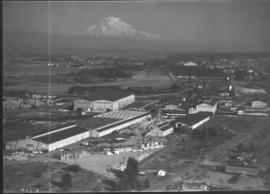
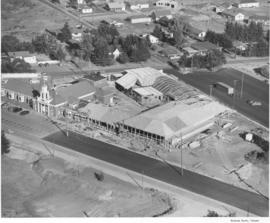
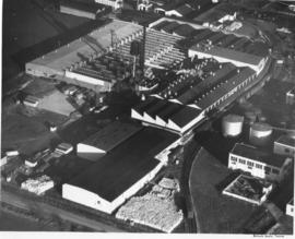
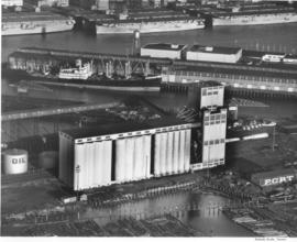
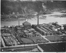
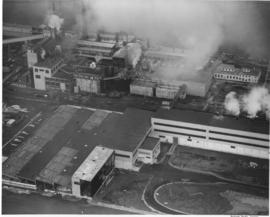
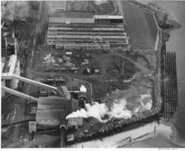
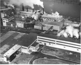
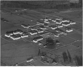
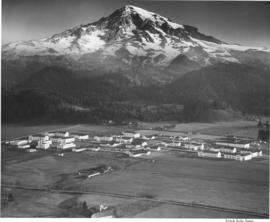
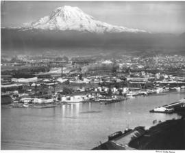
This aerial view of the St. Paul & Tacoma Lumber Company shows Mount Rainier in the background. Included in the photograph are the sawmill, lumber storage and shipping sheds, planing mill, dry kilns, and the barking and chipping plant. The log storage and sorting ponds, railroad log dumps, deep water shipping dock and shed are not shown, as the plant covers an area of 180 acres, about 1/4 mile wide and a mile long. The company sprawled along the St. Paul Waterway, to the left of this photograph, between St. Paul and Portland Avenues. The Puyallup River can be seen heading east with several bridges crossing it. Ordered by St. Paul & Tacoma Lumber Company. (Tree Life Hemlock, St. Paul & Tacoma Lumber Co.)


Aerial photographs; St. Paul & Tacoma Lumber Co. (Tacoma); Cityscapes; Lumber industry--Tacoma--1950-1960;

A59833-1

An aerial view of the new pre-fab plant of Bethlehem Pacific Coast Steel Corporation along a waterway at 8501 East Marginal Way, Seattle.The Seattle Fabricating Works of Bethlehem Pacific was the newest plant in the nation capable of fabricating steel for large buildings, bridges and towers. It was built in 1950 on 8 acres of land on East Marginal Way, across from Boeing Field. It normally had about 250 employees. In the plant, structural steel and plates are cut, punched, drilled, bent, machined and prepared for erection.


Bethlehem Pacific Coast Steel Corp. (Seattle); Aerial photographs; Factories--Seattle;

A60067-1

In July of 1951 a massive addition to the Lakewood Community Center at 6100 Motor Avenue S.W. in Lakewood was under construction. The original center, built by Norton Clapp, opened in July of 1937. With the addition, several new stores were added to the center including Selden's Lakewood. The Lakewood Community Center was one of the country's first one-stop shopping centers. Photograph commissioned by St. Paul & Tacoma Lumber Co. TPL-4412


Aerial photographs; Lakewood Community Center (Lakewood); Progress photographs; Shopping centers--Lakewood--1950-1960;

A60069-3

Aerial photographs of the Holroyd plant were taken in July, 1951. The Holroyd Company was located at 5047 South Washington; they specialized in making concrete masonry units but also manufactured different types of building materials. They also dealt with sand and gravel and steel windows, according to an entry in the 1951 City Directory. Large lake pictured may have been used for manufacturing purposes.


Aerial photographs; Holroyd Co. (Tacoma); Concrete products industry--Tacoma--1950-1960; Building materials industry--Tacoma--1950-1960; Concrete--Tacoma;

A60604-2

Aerial photographs of Mountlake Terrace were taken on August 16, 1951. Developers of this neighborhood near Seattle left many of the trees in the heavily forested area for homeowners to enjoy. Cul-de-sacs were starting to emerge as part of suburban lifestyles, to lessen amount of traffic on roads next to homes and provide safer play areas for children. Photograph commissioned by Budget Homes, Inc.


Aerial photographs; Housing developments--Mountlake Terrace;

A60604-6

Aerial photographs of Mountlake Terrace in August, 1951, show the growing development of the neighborhood near Seattle. Surrounded by heavily forested land, city streets are gradually being laid out and homes built. Developers managed to retain many of the trees while building the new homes. Photograph commissioned by Budget Homes, Inc.


Aerial photographs; Housing developments--Mountlake Terrace;

A60608-1

Aerial photograph of the scenic Columbia River was taken on August 17, 1951. Shadows are falling on the rocky tree-covered hills. There does not appear to be any river traffic at this particular moment in time.


Aerial photographs; Columbia River (Wash.); Rivers--Washington (State);

A62426-2

Aerial photographs were taken of Jefferson Avenue in November, 1951. Building on the right hand corner belongs to Blake, Moffitt & Towne, wholesale distributors of printing and wrapping paper. Rectangular two-story buildings in center of photograph are probably structure known as "Jefferson House", built originally in 1945 to provide emergency accomodations for single men. Jefferson Avenue was primarily a business district, filled with apartment buildings and manufacturers. Photograph ordered by John Huston.


Aerial photographs; Cityscapes; Commercial streets--Tacoma--1950-1960;

A62921-1

An aerial view of the Fibreboard Plant in Sumner. The corrugated box plant had operated in Sumner since 1920. The plant was sold to Louisiana-Pacific Corp. in 1978 who planned to sell the division to a company that was in the container business. Ordered by Moulin Studio. (TNT, 10/10/1978)


Aerial photographs; Fibreboard Corp. (Sumner); Paper industry--Sumner;

A63168-1

An aerial view of the Narrowmoor Addition, a subdivision west of Jackson Avenue. Ordered by Burton W. Lyon, Jr., Puget Sound Bank Building.


Aerial photographs; Housing developments--Tacoma; Land subdivision--Tacoma; Land use--Tacoma; Real estate development--Tacoma;

A63168-2

An aerial view of the Narrowmoor Addition, a subdivision west of Jackson Avenue. Ordered by Burton W. Lyon, Jr., Puget Sound Bank Building.


Aerial photographs; Housing developments--Tacoma; Land subdivision--Tacoma; Land use--Tacoma; Real estate development--Tacoma;

A63168-4

An aerial view of the Narrowmoor Addition, a subdivision west of Jackson Avenue between Sixth and 19th Avenues. The Narrows portion of Puget Sound is below, to the west. The ferry dock at the base of Sixth Avenue can be seen on the left. Ordered by Burton W. Lyon, Jr., Puget Sound Bank Building.


Aerial photographs; Housing developments--Tacoma; Land subdivision--Tacoma; Land use--Tacoma; Real estate development--Tacoma;

A63231-1

Aerial photograph to show the steel work on a new building at St. Regis, Tacoma. Construction of a bag plant at the St. Regis Paper company started in June 1951 with the driving of piling as the first step. The addition was built of steel and concrete and would be used for the production of industrial-use bags for cement, fertilizer and other materials needing heavy-duty holders. When completed, this plant would replace the leased plant at Seattle. (TNT 6/15/1951; St. Regis Paper Company 1951 Annual Report)


St. Regis Paper Co. (Tacoma)--1950-1960; Progress photographs; Building construction--Tacoma--1940-1950; Aerial photographs; Paper industry--Tacoma--1950-1960;

A63233-1

16 new elevators have been added to the existing elevators at the Port of Tacoma. The project added 500,000 bushels to the Port's capacity. Baby flattops (smaller aircraft carriers) are seen across the Port Industrial Waterway. The grain elevators had a 2 million bushel capacity by 1954. They could receive up to 100 cars per day, with 3 receiving legs. Two shipping legs provided shop delivery at a maximum rate of 30,000 bushels per hour. Rail facilities provided for 50 cars to be at the unloading track. There was also a 50 ton hydraulic automatic grain truck dumper. The first pier behind the elevators was Pier 1 and the next one (with a docked ship) was Pier 2. The Port Industrial Waterway was renamed the Blair Waterway in 1970, in honor of past Port of Tacoma Commissioner A.E. Blair. (Tacoma brochure: "Port of Tacoma...Invitation to Industry") (pier identification provided by a reader)


Aerial photographs; Port of Tacoma (Tacoma)--1950-1960; Grain elevators--Tacoma--1950-1960; Aircraft carriers--Tacoma--1940-1950; Harbors--Tacoma; Marine terminals--Tacoma--1940-1950; Shipping--Tacoma--1940-1950;

A63895-1

An aerial view of the plant facility for Hooker Electrochemical Company located at 605 Alexander Avenue on the Tacoma tideflats. The Hylebos Waterway provided excellent accessibility with a company dock and a railroad spur running through the facility enhanced transportation even further. The Port of Tacoma sold an additional 20-acre site to Hooker Electrochemical in December 1951 for $56,400 according to George Osgood, manager of the Port. The property, including a 1,200-foot frontage on the Port-Industrial waterway, was to be used for further expansion of the chemical firm's Tacoma plant. (TNT, 12/16/1951, p.1)


Aerial photographs; Hooker Electrochemical Co. (Tacoma); Logs; Hylebos Waterway (Tacoma); Harbors--Tacoma; Factories--Tacoma--1940-1950; Chemical industry--Tacoma--1950-1960;

A64784-1

An aerial view of the new multiwall bag plant at St. Regis. The plant was completely equipped to produce a full range of multiwall bags. Equipment included six production lines, three printing presses, a complete art and engraving department and auxiliary equipment. This plant replaced a leased plant in Seattle. (TNT, 10/19/1952)


St. Regis Paper Co. (Tacoma)--1950-1960; Aerial photographs; Mills--Tacoma--1950-1960; Paper industry--Tacoma--1950-1960;

A64784-2

An aerial view on February 16, 1952, showing the new multiwall bag plant at St. Regis. St. Regis also had other bag plants on the Pacific Coast at Los Angeles and San Leandro, California. The company also maintained complete engineering and service facilities for automatic bag filling equipment, including a machine shop at Los Angeles, and packer sales and engineering offices at San Francisco and Seattle. The company was self-contained on the west coast. (TNT, 10/19/1952)


St. Regis Paper Co. (Tacoma)--1950-1960; Aerial photographs; Mills--Tacoma--1950-1960; Paper industry--Tacoma--1950-1960;

A64784-3

An aerial view of the new multiwall bag plant at St. Regis. The expansion of the bag plant facilities by St. Regis reflected the continuing trend of industry and agriculture to use the multiwall shipping sack. It was estimated that approximately 2 1/2 billion multiwall bags were used in 1951 for all types of products, compared with less than half a billion in 1938. The multiwall bag came into general use as an industrial container in the mid 1920's and was used for packaging cement and other rock products. Shortly thereafter is was adopted by the sugar industry. (TNT, 10/19/1952)


St. Regis Paper Co. (Tacoma)--1950-1960; Aerial photographs; Mills--Tacoma--1950-1960; Paper industry--Tacoma--1950-1960;

A66035-36

Aerial view of 1952 Daffodil Parade as it proceeds down Pacific Avenue. The 15 mile long parade wound its way down Pacific Ave. from 9th to 19th. A Marine Corps color guard led the parade, followed by the float bearing Queen Eva Beattie and her princesses, royally escorted by the Rosarians of Portland, Oregon. Following the City Light float bearing the Queen were 70 floats and decorated cars, 21 bands, 28 marching units and three mounted groups. (TNT 4-6-1952, pg. 1)


Celebrations--Tacoma; Festivals--Tacoma; Parades & Processions--Tacoma--1950-1960; Puyallup Valley Daffodil Festival (1952 : Tacoma); Drill teams; Marching bands; Floats (parades)--Tacoma--1950-1960; Aerial photographs;

A66035-40

Aerial view of 1952 Daffodil Parade as it proceeds down Pacific Avenue. The day of the parade dawned clear and sunny, prompting 200,000 Tacomans to line the parade route. People stood 10 deep at prime viewing spots, with others watching from windows, awnings, hanging from fire escapes and perching on roofs.


Celebrations--Tacoma; Festivals--Tacoma; Parades & Processions--Tacoma--1950-1960; Puyallup Valley Daffodil Festival (1952 : Tacoma); Drill teams; Marching bands; Floats (parades)--Tacoma--1950-1960; Aerial photographs;

A68175-A

An aerial view of Philadelphia Quartz' plant on the Tacoma tideflats. Belgian silica sand and California soda ash were chemically combined to provide a product sold largely in Tacoma but marketed also in other Northwest cities. Silicate of soda, water-glass to farm households, was used in adhesives for the plywood industry and corrugated paper-board for the container industry.


Chemical industry--Tacoma--1950-1960; Minerals; Philadelphia Quartz Co. of California (Tacoma); Aerial photographs;

A71928-1

Aerial views of Rainier State School in Buckley were taken in late December, 1952, at a height of 800-1000 feet. Rainier School had experienced severe overcrowding in the late 1940's and was forced to request nearly $6,500,000 in aid from state and federal sources to alleviate the housing crunch. Rainier School was only one of two specialized state schools in Washington State and had long waiting lists. It boarded physically and mentally handicapped children, and by the early 1950's, had an enrollment of nearly 2000.


Aerial photographs; Western State Custodial School (Buckley); Institutional care--Buckley; Children--Health & welfare

A71928-3

Mount Rainier looms over the sprawling campus of the Rainier State School in Buckley in December of1952. This aerial photograph, taken at a height of 800-1000 feet, shows the large institution and the rural landscape that surrounded it. The Rainier School, which housed mentally and physically handicapped children, experienced severe overcrowding during the late 1940's to early 1950's.


Aerial photographs; Western State Custodial School (Buckley); Institutional care--Buckley; Children--Health & welfare; Rainier, Mount (Wash.);

A72491-1

ca. 1953. An undated aerial photograph of the industrial Tacoma Tideflats area shows a majestic view of snow-capped Mount Rainier looming in the background. Shaffer Terminals are on the right hand side of City Waterway; the waterway is now known as the Thea Foss Waterway. Shell Oil facilities are probably across from Shaffer's.


Aerial photographs; Rainier, Mount (Wash.); Waterfronts;

Results 121 to 150 of 824