Aerial Photography

Taxonomy

Code

Scope note(s)

Source note(s)

Display note(s)

Hierarchical terms

Aerial Photography

Equivalent terms

Aerial Photography

Associated terms

Aerial Photography

824 Collections results for Aerial Photography

824 results directly related Exclude narrower terms

D154000-271

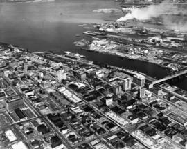
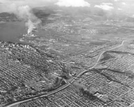
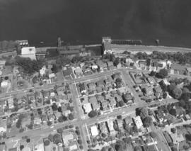
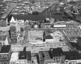
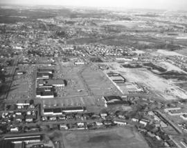
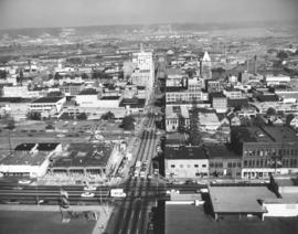
This was the aerial view of Tacoma in September of 1968 looking down South 11th Street towards the Tideflats. At that time South 11th St. was a one-way street. At the bottom edge of the photograph South 11th intersects with Tacoma Avenue South. The roof of the Tacoma Public Library is at the bottom right; the flag on the grass to the left is on the County-City Building's lawn. The new building, under construction at the corner of 11th and Tacoma Ave. South, will be the State Savings & Loan Association building at 955 Tacoma Avenue South. It is across 11th from Siri's Restaurant (later to be Red Kelly's). Rhodes department store is down the hill on the left side; the Puget Sound National Bank's spire is on the right, closer to the waterfront.


Aerial views; Commercial streets--Tacoma--1960-1970; Puget Sound National Bank (Tacoma); Rhodes Brothers Department Store (Tacoma); Siri's Restaurant (Tacoma);

D142189-8

Aerial photograph requested by Puget Sound National Bank and taken in July, 1964, of the Tacoma tideflats area and Port of Tacoma and surrounding neighborhoods. Looking in a northwesterly direction, Gig Harbor and the Peninsula are at the top. Widely channelized Puyallup River is in the center. I-5 freeway runs from the center to the right side of the photograph.


Aerial photographs; Puyallup River (Wash.); Express highways--Tacoma--1960-1970;

D142432-1

Aerial view of the 2600 block of South Tacoma Way featuring Ben's Truck Parts, Frank Buchanan Sales and Steven Motor Co. on August 7, 1964. Ben's Truck Parts and auto wreckers was owned and operated by Ben Etsekson. It was located at 2622 South Tacoma Way next to Frank Buchanan Sales and across the street from the Plymouth-Chrysler dealership. Road in right corner may be Pine St. Photograph ordered by Ben's Truck Parts.


Aerial photographs; Ben's Truck Parts (Tacoma); Automobile equipment & supplies stores--Tacoma--1960-1970; Frank Buchanan Sales (Tacoma); Steven Motor Co. (Tacoma); Signs (Notices);

D144001-297A

Stock footage. Another view by air of downtown Tacoma, City (now Thea Foss) Waterway, and industrial Tideflats area. Tacoma's major business area was still in downtown Tacoma although some major retail stores, like the Bon Marche and soon, J.C. Penney's, had moved out to reach a more suburban clientele. The Tacoma Building on A St. still retained Weyerhaeuser's corporate offices and the Medical Arts Building on Market/St. Helens had not yet become the Tacoma Municipal Building. Major landmarks clearly visible are the County-City Building and Tacoma Public Library on Tacoma Ave. So., Medical Arts Building on St. Helens, Tacoma Building and Perkins Building on A St., 11th Street Bridge, Washington and Rust Buildings and Puget Sound National Bank on Pacific Ave. TPL-10059


Aerial photographs; Commercial streets--Tacoma--1960-1970; Tacoma Building (Tacoma); Medical Arts Building (Tacoma); County-City Building (Tacoma); Tacoma Public Library (Tacoma); Perkins Building (Tacoma); Washington Building (Tacoma);

D145092-3

The new Elks Temple under construction at 1965 So. Union Ave. in June, 1965. The 1.5 million dollar structure is located on the west side of Cedar St., 700 feet south of So. 19th. Ground was broken on April 25, 1964, for the project; seventeen months later in September, 1965, the temple would be dedicated. Eastwardly view of Elks Temple in left lower corner, Allenmore Golf Course, and freeway in the distance.


Aerial photographs; Benevolent and Protective Order of Elks, Tacoma Lodge No. 174 (Tacoma);

D147400-19

ca. 1966. 1966 Richards Studios stock footage. Homes and businesses resemble tiny matchbox buildings when viewed by air in 1966. The newly completed I-5 freeway snakes its way northbound flanked by the populous Eastside and downtown Tacoma regions. Tacoma industrial area to the photograph's left center; smoke billows from St. Regis Paper Co.'s plant, a familiar sight for over 30 years.


Aerial photographs; Express highways--Tacoma--1960-1970; Cityscapes;

C147307-1

ca. 1960. Copy of aerial view of Lakewood business district, including the Lakewood Center and Villa Plaza Shopping Center, ca. the early 1960's. The Lakewood Center, among the first of the nation's one-stop shopping centers, is at bottom center. It is bordered by Bridgeport Way (curving long road on left), Gravelly Lake Dr. and Mt. Tacoma Dr. Towards the center of the photograph is the massive Villa Plaza Shopping Center, built in 1957 on the site of the former 200-acre Visitation Villa. The Villa Plaza constantly promoted their 4000 car parking lot, which may have attracted many shoppers eagerly looking for the convenience of free, available parking. Photograph ordered by the Bank of Tacoma.


Aerial photographs; Shopping centers--Lakewood--1960-1970; Villa Plaza Shopping Center (Lakewood); Lakewood Community Center (Lakewood);

D148098-5

Aerials requested by Puget Sound National Bank. This February, 1966, aerial shows the land and water features just into King County. The large lake in the center of the photograph is Mirror Lake. The road running by it is SW 312th St. 1st Ave. S. is long vertical roadway extending into the trees at the left. The curving road intersecting with 1st Ave. S. is Dash Point Rd. Lakota Jr. High School are buildings located near the upper right adjoining Dash Point Rd. Looking southwesterly toward the top of the photo is the Tideflats industrial area; Hylebos Waterway is visible to the right upper corner.


Aerial photographs; Mirror Lake (Wash.);

D148297-2

Aerial view of Tacoma Boat Building Co. facility on Sitcum Waterway as it looked on March 28, 1966. Started by Haldor Dahl and Arne Strom in 1936, Tacoma Boat Building received many contracts for government vessels and fishing boats. The plant was completely destroyed by fire on August 17, 1968; at $3,905,750, it was the largest single loss fire in the Tacoma Fire Department's history. Photograph ordered by Tacoma Boat Building Co. TPL-9122


Aerial photographs; Tacoma Boat Building Co., Inc. (Tacoma); Boat & ship industry--Tacoma--1960-1970;

D149017-7

Aerial view of Fox Island's southern end. This August 16, 1966, photograph shows that the island is virtually covered with dense forests. There are very few buildings on the island's south end; most appear to be close to the water. Photograph ordered by Swanson-McGoldrick, Inc.


Aerial photographs; Fox Island (Wash.); Forests;

D149017-5

Aerial view, looking east, of Tacoma waterfront and surrounding neighborhoods on August 16, 1966. Northern Pacific Rail tracks curve alongside waterfront. Sperry Flour plant with dock on right-center. Photograph ordered by Swanson-McGoldrick, Inc.


Aerial photographs; General Mills, Inc., Sperry Division (Tacoma); Piers & wharves--Tacoma--1960-1970; Railroad tracks--Tacoma--1960-1970; Waterfronts--Tacoma--1960-1970; Neighborhoods--Tacoma--1960-1970;

D149142-4

Lake City seen in miniature from the air on August 7, 1966. The Lake City neighborhood continued to grow in the mid-60's but there were still many pockets of forested areas visible. Neighborhoods in the Lake City/Lakewood area tended to have larger lots and a more suburban feel. This view appears to have been taken looking north-northwest from the American Lake area, including Veterans Drive S.W. Washington turns into Military Road in upper center of the photograph. Carp Lake is lake above Military Road; large lake at top of photograph is Lake Louise. The Lake City Community Church is the building with the white roof along the right edge near center. Just above it is the Lake City Community Center. On the lower left is visible a portion of the parking lot for the American Lake Park North. Below the curve in the road, just below the center of the photograph, is the Veterans Garage. Photograph ordered by Bank of Tacoma. (Additional information provided by a reader)


Aerial photographs; Neighborhoods--Lake City; Carp Lake (Wash.); Lake Louise (Wash.); Lake City Community Church (Lakewood);

D149142-1

Aerial view of Veterans Drive S.W. area of Lake City taken on August 7, 1966. Shop-Rite Food Center with a few cars parked in front is at right-center. The Veterans Garage is located nestled in the wide curve closer to left-center. Buildings in left corner are part of a neighborhood school. Tip of American Lake can be spotted beyond the trees in right corner. Photograph ordered by Bank of Tacoma.


Aerial photographs; Neighborhoods--Lake City; Shop-Rite Food Center (Lake City); Veterans Garage (Lake City);

D155022-3

Aerials of the Northeast Tacoma - Federal Way area taken on October 30, 1968, on behalf of Puget Sound National Bank. Development is occurring in this location although there is still much forested land. Looking due north, attention is drawn to the long vertical roadway of 21st Ave. S.W. which is in Federal Way. As the road curves toward the left, it becomes 29th St. N.E. in Tacoma. When 21st Ave. splits off to the right, it becomes 356th St. S.W., again in Federal Way. A small shopping center, anchored by National Auto Parts (black roof), faces 21st Ave. S.W. Mosier's Enco Service Station, 35455 21st Ave. S.W., is directly across Blaser's Richfield Service Station on S.W. 356th St. A large water tower emerges from the woods in the upper left section of the picture.


Aerial views; Aerial photographs; Neighborhoods--Federal Way--1960-1970; Neighborhoods--Tacoma--1960-1970; National Auto Parts (Federal Way); Mosier's Enco Service Station (Federal Way); Blaser's Richfield Service Station (Federal Way); Water towers;

D155022-9

This aerial view of the area looking east on 29th St. N.E. was taken in late October of 1968. In the immediate foreground is the Northeast Tacoma Elementary School, 5412 - 29th St. N.E., designed by the architectural firm of Heath, Gove & Bell and built in 1919 with additions following in 1959 and 1973. The black rooftops of the small shopping center containing the National Auto Parts and Walkley's Pharmacy can be seen mid-center of the photograph. Photograph ordered by Puget Sound National Bank.


Aerial views; Aerial photographs; Neighborhoods--Tacoma--1960-1970; Neighborhoods--Federal Way--1960-1970; Northeast Tacoma School (Tacoma);

D155600-68C

1969 Richards stock footage. Looking quite a bit different in May of 1969, the area around So. 72nd and the freeway was starting to be developed commercially. The new Rodeway Inn of America was under construction at 6802 So. Sprague, close to the freeway. Travelers could easily exit the freeway to find comfortable lodgings. A Standard Oil station was conveniently located nearby. The 130-unit luxury motor hotel opened in early November, 1969, with a 90-unit addition planned. (TNT 11-2-69, D-14)


Aerial views; Building construction--Tacoma--1960-1970; Rodeway Inn of America (Tacoma); Motels--Tacoma--1960-1970; Automobile service stations--Tacoma--1960-1970;

D155600-443C

ca. 1969. 1969 Richards stock footage. Viewed by air in 1969, automobiles look like toys piled in heaps at the General Metals of Tacoma scrap yard on Marine View Dr. N.E. A giant crane is positioned on a pier ready to hoist the junked vehicles. General Metals had moved to a 20-acre site on the Hylebos Waterway about 1967. TPL-5902


Aerial views; General Metals of Tacoma Inc. (Tacoma); Junkyards--Tacoma; Hoisting machinery; Hylebos Waterway (Tacoma);

D155600-445C

ca. 1969. 1969 Richards stock footage. Aerial look at the Glacier Sand & Gravel Co. operations in 1969. Several cone-shaped mounds of sand and/or gravel are positioned in a semi-circle at the Glacier Sand & Gravel site on Taylor Way. The sand and gravel could be delivered to the plant by either barge as the site fronted the Hylebos Waterway or by railroad cars and consequently transported out the same way.


Aerial views; Glacier Sand & Gravel Co. (Tacoma); Building materials industry--Tacoma--1960-1970; Hylebos Waterway (Tacoma);

D155600-22C

ca. 1969. 1969 Richards stock footage. Aerial view of large Tudor-styled home with landscaped grounds taken in 1969. Another view of the same property is found at D155600, image 21c. The unidentified home is nestled among large firs. It is believed to be located in the Gravelly Lake Drive area of Lakewood. Although not shown in this particular photograph, the house would have a magnificent view of a pristine lake.


Aerial views; Houses--Lakewood;

D155600-62

This aerial view of downtown Tacoma from May of 1969 centers on the block bordered by South 12th & 13th, and Pacific & A Streets; this block was the future home of the Bank of Washington Plaza. Most of the buildings on the block have been demolished. The empty lot across Pacific (toward the bottom of the photo) will be the site of the Park Plaza South Parking Garage, 1137 Commerce Street. The parking garage was built in 1970. The two tall chimneys, top center, belong to the Tacoma Steam Plant No. 1 (to the left) and the Consumer Central Heating Company. The bridge at the right crossing the the City (now Thea Foss) Waterway is the old 15th Street Railroad Bridge. (TNT 11-20-68, p. 1)


Aerial views; National Bank of Washington (Tacoma); Banks--Tacoma; Building construction--Tacoma--1960-1970; City Waterway (Tacoma);

D155048-4

This aerial view of Tacoma looking north from South 19th Street was taken in November of 1968. The baseball field (lower center) is Heidelberg Field; the cleared land across 19th from the ball park is the future home of the Fred Meyer Department Store. ASARCO smelter's stack puffs a steady stream of smoke in upper center of photograph. Point Defiance is wooded area to the smelter's left. Photograph ordered by Morley Studios. TPL-3804


Aerial views; Neighborhoods--Tacoma--1960-1970; Heidelberg Field (Tacoma);

D155048-5

North end neighborhoods featuring So. 19th & Mason Sts., looking toward downtown and Tideflats. Heavily populated north end still had some sections of woods; nearly all would be eventually developed into businesses and residential housing. Ballpark in right-center is Heidelberg Field. Bare land across So. 19th from ballpark will be a shopping center eventually featuring a Fred Meyer store. So. 19th extends through the woods until it intersects with busy Hwy 16. New road is being constructed west of Heidelberg Field. Photograph ordered by Morley Studios.


Aerial views; Neighborhoods--Tacoma--1960-1970; Heidelberg Field (Tacoma);

D155048-6

Northwest view of north end neighborhoods around So. 19th & Mason. Ballpark on extreme right is Heidelberg Field. Area directly across ballpark on So. 19th will become a large shopping center eventually featuring Fred Meyer store. So. 19th will extend through the woods to intersect with Hwy 16. Also noted: the University of Puget Sound and its Fieldhouse are upper center on 15th & No. Warner. Photograph ordered by Morley Studios. TPL-3800


Aerial views; Neighborhoods--Tacoma--1960-1970; Heidelberg Field (Tacoma);

D155600-144

1969 Richards stock footage. Aerial view of No. James and 11th St. neighborhood taken during the summer of 1969. Sixth Avenue is near the top of the photograph, with Highland Hills and Swasey branch library visible. Hunt Junior High School (now Middle School), with its distinct mushroom-shaped cafeteria, is on So. 10th at the top. James St. is running diagonally into the woods from left to right; Harmon is parallel to James and on its right. No. 13th runs nearly horizontal at the bottom of the photograph; No. 11th is the small segment above it which intersects Harmon and James. The small curved portion on the left corner is the 11th & Bridgeview area. The great expanse of woods pictured above has been developed.


Aerial views; Neighborhoods--Tacoma--1960-1970; Henry F. Hunt Junior High School (Tacoma);

D155600-73C

1969 Richards stock footage. Aerial view of 40th & Bridgeport neighborhood, featuring the University Village Shopping Center. Designed by Lyle Swedberg & Associates and built by James Kirkebo & Son, Inc., the shopping center opened in October of 1967. The main occupants were the Food King supermarket and Don's Village Drugs. Ample free parking was provided for customers who could enjoy "one-stop" shopping in the center for groceries, prescriptions, apparel, gasoline and restaurant cooking.


Aerial views; Neighborhoods--University Place, Shopping centers--University Place; Food King (University Place);

D155600-442C

ca. 1969. 1969 Richards stock footage. Work is still continuing on Western Boat Building's new shipyard on the Hylebos Waterway in 1969. The foundations of a new dock are being laid in place in front of the main plant. The roadway behind the large seven-acre lot is Marine View Dr. N.E. Western Boat had decided to move to its new location so that larger boats could be built in their modernized plant and once the dock was completed, repairs could be done on vessels dockside. TPL-9224


Aerial views; Western Boat Building Co. (Tacoma); Boat & ship industry--Tacoma--1960-1970; Hylebos Waterway (Tacoma); Piers & wharves--Tacoma--1960-1970;

D156021-10

Aerial view, looking north, of the Villa Plaza Shopping Center and various Lakewood neighborhoods on February 26, 1969. The shopping center, with its vast parking lot, is in the center of the photograph. At the bottom left corner is part of Clover Park High School with ball field. A portion of the Lakewood Center can be spotted on the left side of the photograph. Lockburn Junior High, Flett Dairy and Clover Park Voc-Tech are also visible. The Villa Plaza Shopping Center would be renamed the Lakewood Mall in 1989. Photograph ordered by Puget Sound National Bank.


Aerial views; Villa Plaza Shopping Center (Lakewood); Shopping centers--Lakewood--1960-1970; Neighborhoods--Lakewood--1960-1970;

D156028-1

This is how the area around South 72nd Street and I-5 appeared by air in March of 1969. Wapato Lake off of Alaska Street is the large body of water nestled among trees. The cluster of buildings on the far left is the Roadway Inn of America under construction at 6802 So. Sprague. Nearby is a Standard Oil station. This photograph was taken for the Wapato Lake Development Company who had sought permission from the City Planning Commission in early February, 1969, to build a 234-unit lowrise apartment complex on a 12-acre site north of South 72nd between Alaska Street and the freeway. This would entail rezoning and be subject to approval from the city council. We find no record that this complex was built. (TNT 2-4-69, p. 10) TPL-9697


Aerial views; Wapato Lake (Tacoma); Express highways--Tacoma--1960-1970; Rodeway Inn of America (Tacoma);

D162638-10C

This is the Kaiser Aluminum plant in the tideflats as seen by air during the fall of 1972. The 500-foot smokestack was built in 1968 during plant expansion. Photograph taken on speculation.


Aerial views; Kaiser Aluminum & Chemical Corp. (Tacoma); Aluminum industry--Tacoma--1970-1980; Smokestacks--Tacoma;

C162245-1

Copy of customer print. Aerial view of Tacoma Boatbuilding's plant alongside the Hylebos Waterway taken post-1969. The company's former location on the Sitcum Waterway had been destroyed by fire in 1968. They chose to build a new plant on Marine View Dr. on the Hylebos on 20 acres of land. Photograph ordered by Tacoma Boatbuilding.


Aerial views; Boat & ship industry--Tacoma--1970-1980; Tacoma Boat Building Co., Inc. (Tacoma); Hylebos Waterway (Tacoma); Logs;

Results 151 to 180 of 824