Aerial Photography

Taxonomy

Code

Scope note(s)

Source note(s)

Display note(s)

Hierarchical terms

Aerial Photography

Equivalent terms

Aerial Photography

Associated terms

Aerial Photography

824 Collections results for Aerial Photography

824 results directly related Exclude narrower terms

C130947-1

ca. 1961. Aerial photograph of Rocky Ridge Ranch. Snow-capped Mount Rainier in background. There are at least two houses on the ranch with four outbuildings, two of them barns. Photograph ordered by Harold Allen Co. on May 16, 1961.


Aerial photographs; Ranches; Rainier, Mount (Wash.);

C134216-1

ca. 1962. Copy of customer print. Aerial photograph of Tacoma's northend, specifically the University of Puget Sound campus, ca. 1962. This copy has been retouched; dark rectangular and square shapes seem to indicate where new construction will be occurring on the campus. The university planned to put in five new fraternity houses directly across the street from the campus and build two women's dorms to supplement Anderson and Harrington Halls. Photograph ordered by the North Pacific Bank Note Co.


Aerial photographs; University of Puget Sound (Tacoma)--1960-1970; Neighborhoods--Tacoma--1960-1970;

C147307-1

ca. 1960. Copy of aerial view of Lakewood business district, including the Lakewood Center and Villa Plaza Shopping Center, ca. the early 1960's. The Lakewood Center, among the first of the nation's one-stop shopping centers, is at bottom center. It is bordered by Bridgeport Way (curving long road on left), Gravelly Lake Dr. and Mt. Tacoma Dr. Towards the center of the photograph is the massive Villa Plaza Shopping Center, built in 1957 on the site of the former 200-acre Visitation Villa. The Villa Plaza constantly promoted their 4000 car parking lot, which may have attracted many shoppers eagerly looking for the convenience of free, available parking. Photograph ordered by the Bank of Tacoma.


Aerial photographs; Shopping centers--Lakewood--1960-1970; Villa Plaza Shopping Center (Lakewood); Lakewood Community Center (Lakewood);

C148862-3

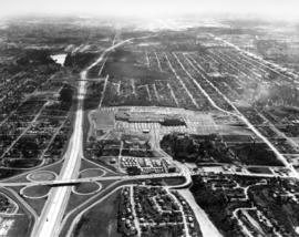
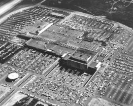
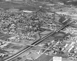
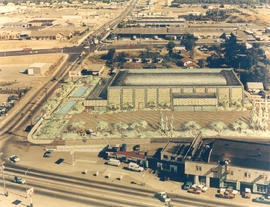
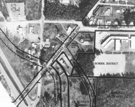
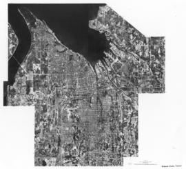
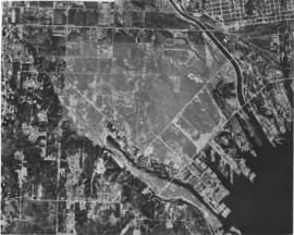
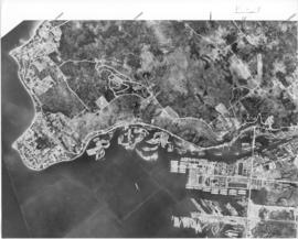
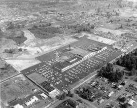
ca. 1966. This aerial view of Tacoma south of the I-5/ South 38th Street interchange was taken several months after the Tacoma Mall Shopping Center had its grand opening in October 1965. The Mall, with some 70 stores including J.C. Penny, Kress, a Thriftway supermarket and the Bon Marche, offered parking for 7,000 cars. The bright area above and to the left of the 56th Street cloverleaf is Wapato Lake. The housing area at the bottom, to the right, is Lincoln Heights. When this photograph was taken the Mall was an island of commercial property surrounded by residential housing. (Photograph ordered on June 7, 1966, by Bank of California.)


Aerial photographs; Express highways--Tacoma--1960-1970; Tacoma Mall Shopping Center (Tacoma); Shopping centers--Tacoma--1960-1970; Wapato Lake (Tacoma); Neighborhoods--Tacoma--1960-1970;

C148862-4

ca. 1966. Copy of customer's print. Closer aerial view of the new Tacoma Mall Shopping Center ca. 1966. The Tacoma Mall had expanded to 70 stores when it opened officially in October, 1965. It touted the 7000+ parking spots available to shoppers without charge and this ca. 1966 photograph indicates that thousands would take advantage of the easy parking and climate-controlled enclosed mall. Downtown merchants and officials would try to counter with ads remarking on the variety of choices a downtown shopper would have with competition keeping prices reasonable and meter maids were even putting extra nickels into parking meters to give customers a bit more time to shop. Still, the lure of the modern roofed mall would be hard to resist for thousands of shoppers from Olympia to Seattle. View of expanded Tacoma Mall with Bon Marche on center right, J.C. Penney's in center left, National Bank of Washington circular bank building at lower left. Nordstrom-Best would be the next large company to join the mall, opening in August, 1966. Photograph ordered on June 7, 1966, by Bank of California.


Aerial photographs; Tacoma Mall Shopping Center (Tacoma); Shopping centers--Tacoma; Bon Marche (Tacoma); J.C. Penney Co. (Tacoma); National Bank of Washington (Tacoma);

C152548-1

ca. 1967. Copy of aerial print of Puget Sound region featuring major and projected freeways, ca. 1967. Seattle-Tacoma Airport's proximity to an anticipated Multi-Purpose Stadium is noted. Freeways are labeled and locations accentuated by white lines. Pierce County residents would be asked to support a $10 million bond that would assist King County in building a sports stadium should a site be chosen south of the airport. Photograph ordered by advertising agency Bozell & Jacobs on October 30, 1967. (TNT 10-31-67, p. 1)


Aerial photographs; Express highways--Wash.;

C152548-2

ca. 1967. Copy of customer's print. Closer view of aerial with names of various freeways and major roadways, present and projected, ca. 1967. There had long been talk about building a multi-purpose stadium in the Puget Sound region. This map shows the proximity of such a stadium to major freeways and the Seattle-Tacoma Airport. Even rapid transit was a future prospect to bring visitors and patrons to this area. The Pierce County Sports Stadium Advisory Committee had proposed a 120-acre site at the intersection of So. 277th & West Valley Highway in King County. A group of Tacoma citizens had an option on the land. Pierce County residents were to vote on a $10 million bond issue to help King County build a stadium if a site was chosen south of the airport. Photograph ordered on October 30, 1967, by Bozell & Jacobs Advertising. (TNT 10-31-67, p. 1)


Aerial photographs; Express highways--Wash.;

C153566-1

Copy of customer copy. Aerial view of SR410, Puyallup to Sumner, with major state routes and roads clearly marked, ca. January, 1968. Visible are SR 161, 512, 167 and 410. Photograph ordered by Ward Smith, Inc., on February 20, 1968.


Aerial photographs; Express highways--Wash.;

C153566-3

Copy of customer's print. Photograph by air of SR 512 in Puyallup dated December, 1967. Major streets in Puyallup including 10th St. SE, Main Ave., Pioneer and Milwaukee, are clearly labeled as well as SR410 and directions to neighboring cities of Tacoma, Sumner and Parkland. The proposed Puyallup Valley freeway's effect on Puyallup is shown in the above mockup by the State Department of Highways. The system should be operable by late 1970. It was expected to cost $16 million dollars. Photograph ordered by Ward Smith, Inc., on February 20, 1968. (TNT 3-26-68, p. 8)


Aerial photographs; Express highways--Wash.;

C156164-1

ca. 1969. This "artistically modified" view of downtown Tacoma was created for the Downtown Tacoma Association in 1969. Along with the Bank of Washington building at 1201-23 Pacific Avenue, it shows a second high-rise building in the 1100 block of Pacific and numerous parking structures on Market and on the south end of Broadway. The building at the corner of 11th and pacific is at least twice the height of the Pacific First Federal building that was built on that site. Only the Washington Plaza (now Wells Fargo Plaza), which was completed in January of 1971, was built more or less as visualized.


Aerial views; National Bank of Washington (Tacoma); City Waterway (Tacoma); Commercial streets--Tacoma--1960-1970;

C159700-684

ca. 1971. Customer copy of downtown Tacoma landscape taken from the air, circa 1971. Snow-capped Mount Rainier looms in the background. Prominent buildings include the Art-Deco styled Medical Arts Building (now the Municipal Building) in lower left; Puget Sound National Bank with its distinctive spire; the 22+ story Bank of Washington Plaza building, the Washington Building with the neon Bank of California sign on its root; and Schoenfelds furniture store.


Aerial views; Business districts--Tacoma--1970-1980; Rainier, Mount (Wash.); Medical Arts Building (Tacoma); Puget Sound National Bank (Tacoma); Washington Building (Tacoma); L. Schoenfeld & Sons (Tacoma); Pacific National Bank of Washington (Tacoma);

C160915-1C

ca. 1971. Aerial view of former Tacoma Sports Arena with artist's rendering of possible architectural changes. Ben's Truck Parts had purchased the Tacoma Sports Arena (known prior as the Tacoma Ice Palace) on September 3, 1971. The company had commissioned the Richards Studio to take several aerial photographs of the Arena and vicinity. This aerial view shows possible architectural changes to the building and site with shimmering pools facing So. 38th St. and a profusion of trees and shrubs added. The exterior of the building would also change with walls apparently extended and a changed roofline. The location was easily accessible by traveling on So. 38th St. (now one of the city's busiest streets due to the close proximity to the Tacoma Mall), South Tacoma Way, and from the north, Union Ave. Color photograph ordered by Ben's Truck Parts.


Aerial views; Renderings; Tacoma Sports Arena (Tacoma); Tacoma Ice Palace (Tacoma);

C162245-1

Copy of customer print. Aerial view of Tacoma Boatbuilding's plant alongside the Hylebos Waterway taken post-1969. The company's former location on the Sitcum Waterway had been destroyed by fire in 1968. They chose to build a new plant on Marine View Dr. on the Hylebos on 20 acres of land. Photograph ordered by Tacoma Boatbuilding.


Aerial views; Boat & ship industry--Tacoma--1970-1980; Tacoma Boat Building Co., Inc. (Tacoma); Hylebos Waterway (Tacoma); Logs;

C162499-1

ca. 1972. Copy of customer print, ordered by law firm of Murray, Scott & McGavick on October 16, 1972. This is an aerial of the Gig Harbor area with various streets and company names written in. It appears that future construction of on and off-ramps and an overpass will impact housing and businesses already present. This is in the vicinity of Wollochet Gig Harbor Road.


Aerial views; Maps;

C163000-600C

Undated color copy of photograph from the 1973 Richards stock footage. Aerial view of the Grand Coulee Dam and surrounding area. The dam is in the center with Lake Roosevelt behind. The Grand Coulee is a large hydroelectric dam located on the Columbia River.


Aerial views; Dams--Grand Coulee;

C163175-1C

ca. 1973. Copy of customer print ordered on April 5, 1973, by Tacoma Boatbuilding. Colorful aerial view of Tacoma Boatbuilding's 20-acre plant on the Hylebos Waterway. Three cargo ships, including the "Atlantis," are in port. Tacoma Boatbuilding had moved to 1840 Marine View Dr. N.E. in 1969 after fire had destroyed their longtime Sitcum Waterway plant.


Aerial views; Tacoma Boat Building Co., Inc. (Tacoma); Boat & ship industry--Tacoma--1970-1980; Cargo ships--Tacoma; Hylebos Waterway (Tacoma);

C50632-1

Copy of aerial view of West Coast Grocery Company with Mount Rainier in the background. West Coast Grocery was an outlet for national and local brand foods to be shipped throughout the Pacific Northwest, Hawaii and Alaska. The company had served Tacoma and Alaska since 1887. Their brand name, Amocat (Tacoma spelled backwards), was a guide to shoppers to quality food products. Ordered by West Coast Grocery, Chet Chumington. (TNT, 2/13/1951, p.C-2)


Aerial photographs; Commercial facilities--Tacoma; West Coast Grocery Co. (Tacoma); Business enterprises--Tacoma--1950-1960; Storehouses--Tacoma; Rainier, Mount (Wash.); Mountains;

C72770-1

Copy of undated aerial photograph of the City of Tacoma as mosiaclike map was made for a sample book. TPL-8739


Aerial photographs; Maps;

C84642-1

Copy of customer's print. The Port of Tacoma Industrial area is seen in an aerial view in a photograph copied for Howard R. Smith. Mr. Smith, a well-known Tacoma businessman, had been president of the Tacoma Athletic Commission and involved in advertising for many years. The photograph was copied on August 27, 1954; actual date of print is unknown. Log dumps for various lumber concerns are clearly visible to the picture's right.


Aerial photographs; Port of Tacoma (Tacoma);

C87485-B

ca. 1949. Aerial view, believed to have been taken in December of 1949, of downtown business district featuring Columbia Breweries (center) on South "C" Street where the sprawling plant covered 3-4 acres. Snow is gradually melting over the rooftops on this sunny winter day. The Hunt & Mottet Co. building is at the right foreground.


Aerial views; Aerial photographs; Columbia Breweries, Inc. (Tacoma)--1940-1950; Brewing industry--Tacoma--1940-1950; Hunt & Mottet Co. (Tacoma); Commercial streets--Tacoma--1940-1950;

C87936-A

Aerial view of the Port of Tacoma, for Cheney Lumber Co. The Port Piers and the Naval Station, with mothballed fleet, can be seen. There were 25 mothballed escort carriers under the care of the Tacoma Group, Pacific Reserve Fleet. The ships were serviced and kept in readiness for war. The Hylebos Waterway can be clearly see all the way to the turning basin. The roads appear as clear white lines. TPL-2261


Aerial photographs; Bays--Washington (State); Commencement Bay (Wash.); Port of Tacoma (Tacoma)--1950-1960;

C87936-B

Aerial view of the Port of Tacoma, for Cheney Lumber Co. Port Piers, Naval Station (with mothballed fleet) and Hylebos Waterway can be clearly seen. Photo continues around Browns Point and on to Dash Point. Roads appear as clear white lines. TPL-2262


Aerial photographs; Bays--Washington (State); Commencement Bay (Wash.); Port of Tacoma (Tacoma)--1950-1960;

D101899-2

A rare early snowfall blankets the earth in this aerial shot of the Hylebos Waterway in October of 1956. Log booms float in the water and part of the mothballed fleet of escort carriers, kept in readiness under the care of the Tacoma Group, Pacific Reserve Fleet, can be seen. Mt. Rainier is partially obscured by haze and smoke rising from the industrial sites on the Tideflats.


Aerial photographs; Hylebos Waterway (Tacoma); Snow--Tacoma--1950-1960;

D105615-1

This aerial view of Tacoma's West End and the Tacoma Narrows Bridge was taken in March of 1957. 6th Avenue cuts upward through the center of the picture curving to the right as it feeds onto the Narrows Bridge. The road starting at the bottom right and running into 6th Ave. is Pearl Street, with the Tacoma Auto View Theater, 1202 North Pearl near the right edge. The buildings at the corner of 6th and Pearl are the early Highland Hills Shopping Center, 5915 6th Ave.. The bare land just above and to the right of the Auto View became the Highland Hills Golf Course.


Aerial photographs; Tacoma Narrows Bridge (Tacoma); Neighborhoods--Tacoma--1950-1960;

D108639-2

Lakewood Center as pictured by air in August of 1957. Located near the busy streets of Bridgeport Way and Gravelly Lake Dr., the Lakewood Center was among the first of the nation's one-stop shopping centers. It underwent several expansions including a major addition in 1955 when the modified Colonial, shown above with an "open" triangular side, opened with fourteen new businesses. The shopping center was 15 minutes from downtown Tacoma, five minutes from McChord and ten from Fort Lewis. It provided an alternative shopping area for residents in the communities outside Tacoma city limits with the added attraction of more parking than in downtown Tacoma.


Aerial photographs; Lakewood Community Center (Lakewood); Shopping centers--Lakewood--1950-1960;

D108639-5

Aerial view of the Villa Plaza Shopping Center taken for its opening in August of 1957. One thing was clear: there was plenty of parking available for shoppers at Lakewood's newest shopping center, the Villa Plaza, and plenty of room for expansion if necessary. The Villa Plaza heavily advertised its free 4000-car parking lot and the convenience of many stores side-by-side including familiar names J.C. Penney's, Woolworth's and Rhodes Brothers. Acknowledging the buying power of suburbanites, these major department stores left their flagship operations downtown but garnered new shopping dollars by opening branches outside city limits. The Villa Plaza, like the older Lakewood Center, was closer to McChord and Fort Lewis than downtown.


Aerial views; Aerial photographs; Villa Plaza Shopping Center (Lakewood); Shopping centers--Lakewood--1950-1960; Parking lots--Lakewood;

D109420-7

Aerial photographs- U.S. Oil Refinery. Aerial photographs of the U.S. Oil refinery were taken on October 3, 1957. The petroleum "tank farm" was located on an 120 acre site in the Tideflats. The light colored round cylinders shown in the photograph are probably the storage tanks. The refinery would be close to both rail and water transport. Photograph ordered by U.S. Oil & Refining Co.


Aerial photographs; Storage tanks--Tacoma; US Oil & Refining Co. (Tacoma);

D111635-1

This was how Tacoma's Tideflats appeared from the air on January 3, 1958. The area was crowded with pulp and paper mills, lumber yards, log ponds and warehouses. Tacoma's easy access to rail and water made the transport of industrial and wood products a simpler process. View of, left to right, the City, Middle, St. Paul and Puyallup Waterways. The St. Regis plant was located on the finger between the Puyallup and St. Paul waterways in the buildings with the "L" shape. The St. Paul & Tacoma Lumber sawmill and buildings were close by, at the rear of the waterway in the loaf shaped buildings. In August 1957, St. Paul became an operating subsidiary of the St. Regis Paper Co. Photograph ordered by Malcolm McGhie.


Aerial photographs; St. Regis Paper Co. (Tacoma)--1950-1960; St. Paul & Tacoma Lumber Co. (Tacoma);

D111635-2

Additional aerial photographs of the Tideflats area were requested by Malcolm McGhie and taken on January 3, 1958. Earlier photographs were taken about a month prior. Dash Point can be spotted protruding into the bay on the right with Vashon Island at the top of the photograph. St. Paul & Tacoma Lumber Co., who in August, 1957, became a subsidiary of St. Regis Paper Co., can be clearly seen towards the middle of the photograph including its loaf-shaped buildings. Its sawmill had provided 35% of the pulp mill's wood requirements. St. Regis is adjacent to its new subsidiary and to the upper right. The City Waterway is the body of water to the extreme left; new developments, with the removal of warehouses, shipbuilding, and mills nearly 45 years later have changed its landscape and revitalized the area.


Aerial photographs; St. Paul & Tacoma Lumber Co. (Tacoma); St. Regis Paper Co. (Tacoma)--1950-1960;

D11649-10

This aerial view of the Pierce County Hospital and its surrounding neighborhood was taken in July of 1941. The hospital's new north wing and new west wing were nearing completion. An extra three-mil tax levy was passed in March of 1940 to fund the expansion of the hospital. At the upper left corner is the excavation for the Lincoln Bowl, which was not completed until after WWII. Pierce County took over ownership of the hospital in 2000. (T.Times 7/31/1941 p.5)


Aerial photographs; Pierce County Hospital (Tacoma); Neighborhoods--Tacoma--1940-1950;

Results 181 to 210 of 824