Aerial Photography

Taxonomy

Code

Scope note(s)

Source note(s)

Display note(s)

Hierarchical terms

Aerial Photography

Equivalent terms

Aerial Photography

Associated terms

Aerial Photography

824 Collections results for Aerial Photography

824 results directly related Exclude narrower terms

D75453-3

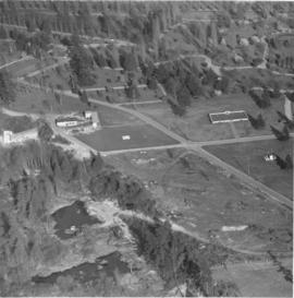
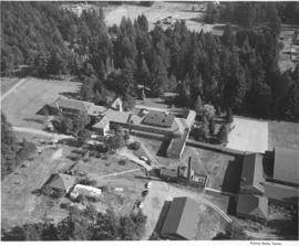
This was how Marymount Military Academy appeared from the air on July 28, 1953. The Academy was the only military school in Washington State. Located in what would now be Spanaway, the school was run by the Dominican Sisters, a Catholic teaching order. Young boys aged 6-16 were accepted for enrollment at this boarding school. Ground was broken at the site in July of 1922 and the school was dedicated in May of 1923. Built at a cost of $200,000 on the former "Shangarry" estate of J. Shields, Marymount originally was built in the Lombardine Mission style with modern gym, pool and infirmary. Enrollment was capped at 150 students; however, lessening enrollment and higher operating costs forced closure of the school in 1976. The property was purchased in the 1980's by Harold LeMay, who used much of it to house his antique car collection. TPL-9701


Aerial photographs; Marymount Military Academy (Spanaway); Private schools--Spanaway; Military education--Spanaway;

D77321-6

Aerial of downtown Tacoma looking west from the Eleventh Street Bridge. The Dock Street Steam Plant can be seen at lower left. Railroad tracks and a green belt divide the commercial downtown area from the waterfront. The bridge crosses over the City Waterway into the industrial area.


Aerial photographs--1950-1960; Business districts--Tacoma--1950-1960;

D77321-1

This is an aerial of downtown Tacoma looking west from 11th and A street as it appeared in August of 1953. Beginning span of the 11th Street Bridge at lower right corner and smoke stacks from Dock Street Steam plant at lower left.


Aerial photographs--1950-1960; Business districts--Tacoma--1950-1960; 11th Street Bridge (Tacoma); Bridges--Tacoma--1950-1960; Commercial streets--Tacoma--1950-1960;

D77321-8

Aerial of downtown Tacoma looking west from the intersection of Eleventh and A streets.


Aerial photographs--1950-1960; Business districts--Tacoma--1950-1960;

D77321-7

Aerial of downtown Tacoma looking west from the Eleventh Street Bridge. The bridge crosses the City Waterway and provides transportation from the commercial downtown area to the industrial area.


Aerial photographs--1950-1960; Business districts--Tacoma--1950-1960;

D77321-2

Aerial of downtown Tacoma looking west up 11th Street from the Eleventh Street Bridge, taken on August 18, 1953.


Aerial photographs--1950-1960; Business districts--Tacoma--1950-1960; 11th Street Bridge (Tacoma); Bridges--Tacoma--1950-1960; Commercial streets--Tacoma--1950-1960;

D77321-4

Aerial of downtown Tacoma looking west from the intersection of 11th & A Streets. The Dock Street Steam Plant can be seen in the left hand foreground and the Eleventh Street Bridge on the right. The Eleventh Street Bridge crosses the City Waterway and leads to the Tideflats and Port of Tacoma industrial areas.


Aerial photographs--1950-1960; Business districts--Tacoma--1950-1960; 11th Street Bridge (Tacoma); Commercial streets--Tacoma--1950-1960;

A80571-1

Blair Bridge over the Port Industrial Waterway in the closed position, photographs ordered by State Highway Department. The bridge opened in November of 1953. It was a lift bridge structure, a double leaf Bascule span. There was a 150 foot channel between the main piers for the passage of shipping vessels. The bridge was constructed for a cost of $1,600,000. (TNT 11/13/1953, section D)


Port of Tacoma (Tacoma)--1950-1960; Aerial photographs; Harbors--Tacoma; Port Industrial Waterway Bridge (Tacoma); Vertical lift bridges; Bridges--Tacoma; Blair Bridge (Tacoma);

A80571-6

Blair (Port Industrial Waterway) Bridge in the open position, for the State Highway Department. The bridge opened for traffic in November of 1953, cutting commuting time in the Tideflats. It is a lift bridge with a 150 foot channel between the main piers for the passage of shipping vessels. The two main channel piers house the operating machinery for opening and closing the span drawbridge. They are the equivalent in height, measured above and below the water, to a seven story building. (TNT 11/13/1953, Section D)


Port of Tacoma (Tacoma)--1950-1960; Aerial photographs; Harbors--Tacoma; Port Industrial Waterway Bridge (Tacoma); Vertical lift bridges; Bridges--Tacoma; Blair Bridge (Tacoma);

A80571-4

Blair (Port Industrial Waterway) Bridge in open position, for the State Highway Department. Mothballed WWII "Jeep" Carriers in background. The fleet of 25 mothballed escort carriers was kept in combat readiness by the Pacific Reserve Fleet. The bridge opened for traffic in November of 1953. It is a lift bridge, opening for seagoing vessel traffic. The bridge is 712 feet long with a 40 foot roadway and 5 feet of sidewalk on one side only. (TNT 11/13/1953, section D)


Port of Tacoma (Tacoma)--1950-1960; Aerial photographs; Harbors--Tacoma; Port Industrial Waterway Bridge (Tacoma); Vertical lift bridges; Bridges--Tacoma; Blair Bridge (Tacoma);

D81185-9

Aerials of the Port of Tacoma, c. 1954. The Port Industrial Waterway takes up most of the photograph with the mothballed WWII flattops stored in readiness for combat activation next to the U.S. Naval Station. The round storage tanks at Hooker Electrochemical can be seen behind the fleet of ships. The Port of Tacoma fingertip piers lie along the other side of the Waterway. The round storage tanks of Time Oil Co. and the Port of Tacoma Grain Elevators occupy the tip of land jutting out between the Port Industrial Waterway and the Sitcum Waterway. TPL-2250


Aerial views; Port of Tacoma (Tacoma)--1950-1960;

D81185-A

Aerial view of Tacoma industrial Tideflats in 1954 with major focus on the Port Industrial Waterway. Mothballed WWII flattops are positioned close to the U.S. Naval Station. A collection of log booms are amassed in the Sitcum Waterway. The tip of Mount Rainier can be spotted at the top of the photograph.


Aerial photographs; Port of Tacoma (Tacoma)--1950-1960; Sitcum Waterway (Tacoma); Port Industrial Waterway (Tacoma); Logs; Rainier, Mount (Wash.);

D81185-4

Aerials of the Port of Tacoma, circa 1954, with Mount Rainier in the background. From left to right lies the U.S. Naval Station with the mothballed fleet of flattops, kept in readiness, on the Port Industrial Waterway. The fingertip piers of the Port of Tacoma can also be seen on the Industrial Waterway. The Port of Tacoma grain elevators lie at the tip of land facing the Sitcum Waterway. The large, almost rectangular Sitcum Waterway holds many log booms. Tacoma Boat Building's tall sheds for drydock can be seen on the other side of the waterway. The smaller Milwaukee Waterway separates the Henry D. Gee Co. Grain Storage and the Puget Sound Freight Lines. TPL-2255


Aerial views; Port of Tacoma (Tacoma)--1950-1960; Rainier, Mount (Wash.); Port Industrial Waterway (Tacoma); Sitcum Waterway (Tacoma);

D87494-1

Aerial of Dash Point. Sky Harbor Airport. A pier juts out into the water. Several large residential homes can be seen at the water's edge. TPL-5564


Aerial photographs; Piers & wharves--Dash Point; Neighborhoods--Tacoma--1950-1960;

C84642-1

Copy of customer's print. The Port of Tacoma Industrial area is seen in an aerial view in a photograph copied for Howard R. Smith. Mr. Smith, a well-known Tacoma businessman, had been president of the Tacoma Athletic Commission and involved in advertising for many years. The photograph was copied on August 27, 1954; actual date of print is unknown. Log dumps for various lumber concerns are clearly visible to the picture's right.


Aerial photographs; Port of Tacoma (Tacoma);

D85642-1

An aerial photograph of the sprawling Pennsylvania Salt Manufacturing Co. of Washington was taken in October, 1954. The Tacoma plant, whose parent company was founded over one hundred years ago in Natrona, Pennsylvania, has been at its 40 acre Tideflats location on the Hylebos waterway since 1929. Throughout the years, it has undergone rapid expansion of its facilities and also its product lines. Despite its name, it has no connection with the manufacture of table salt. Photograph ordered by Pennsylvania Salt Manufacturing Co. of Washington.


Aerial photographs; Pennsylvania Salt Manufacturing Co. of Washington (Tacoma); Chemical industry--Tacoma--1950-1960; Hylebos Waterway (Tacoma);

C87936-B

Aerial view of the Port of Tacoma, for Cheney Lumber Co. Port Piers, Naval Station (with mothballed fleet) and Hylebos Waterway can be clearly seen. Photo continues around Browns Point and on to Dash Point. Roads appear as clear white lines. TPL-2262


Aerial photographs; Bays--Washington (State); Commencement Bay (Wash.); Port of Tacoma (Tacoma)--1950-1960;

C87936-A

Aerial view of the Port of Tacoma, for Cheney Lumber Co. The Port Piers and the Naval Station, with mothballed fleet, can be seen. There were 25 mothballed escort carriers under the care of the Tacoma Group, Pacific Reserve Fleet. The ships were serviced and kept in readiness for war. The Hylebos Waterway can be clearly see all the way to the turning basin. The roads appear as clear white lines. TPL-2261


Aerial photographs; Bays--Washington (State); Commencement Bay (Wash.); Port of Tacoma (Tacoma)--1950-1960;

A93890-3

Aerial photographs of possibly military base were taken in November, 1955, on behalf of the law firm of Anderson, Pearson & Anderson. This may be on the grounds of Fort Lewis. There appears to be a church with steeple in the far left corner of the photograph. Other buildings appear to be temporary barracks.


Aerial photographs; Anderson, Pearson & Anderson (Tacoma);

A94417-2

This aerial view of the Lakewood Center was taken in November of 1955 on behalf of the Lakewood Development Co., who operated the community center. Norton Clapp had originally built the Lakewood Community Center in 1937 as one of the nation's first one-stop shopping centers. Clapp, known as the founder of Lakewood, nurtured the idea of a growing suburban community and realized that it would need additional businesses and services to help it grow. The Lakewood Center underwent several expansions in the 1950's. In November, 1955, it reopened to celebrate a new addition, the modernized Colonial in an open triangle shape on the east side of the center. One 285-ft. leg faced Gravelly Lake Dr., the other 235-ft leg faced Mt. Tacoma Dr. with the "open" side to Bridgeport Way. Fourteen new businesses, including Sprouse-Reitz variety store, Lakes Realty, Andrews Women's Apparel, Lou Johnson, Selden's, Tacoma Savings and Loan, and Lakewood Record and Book Shop, took occupancy in the new building. (TNT 11-16-55, C-14)


Aerial photographs; Lakewood Community Center (Lakewood); Shopping centers--Lakewood--1950-1960; Lakewood Development Co. (Lakewood);

A94417-1

Aerial photographs were taken of the Lakewood Center on November 4, 1955. Originally built in 1937 by Norton Clapp, the Lakewood Community Center was among the first of the country's one-stop shopping centers. It had undergone tremendous expansion in the early 1950's to keep up with the rapidly growing suburban area surrounding Lakewood. The Center was to celebrate its grand reopening later in November, 1955, with the addition of the large building nearest the bottom. It would be designed by the architectural firm of Lea, Pearson & Richards in the shape of an open triangle. The longer side, 285 feet, would face Gravelly Lake Drive with the shorter 235 foot side facing Mt. Tacoma Dr. The service or open side faces Bridgeport. Parking was available all around the building. Fourteen shops had already reserved space in the new addition. Photograph ordered by Lakewood Development Co. (TNT 11-16-55, C-14)


Aerial photographs; Lakewood Community Center (Lakewood); Shopping centers--Lakewood--1950-1960; Lakewood Development Co. (Lakewood);

A98409-1A

ca. 1956. Mountain View Memorial Park in Lakewood. An aerial view of the cemetary. This is the left hand side of a large print of a single negative. For the right hand side see A98409 image 1b. Curved roads wind through the grounds providing access to the many grave sites. The war memorial can be seen right, just below center. Other structures located in the park include the funeral home, crematory, mausoleum, chapel and columbarium.


Cemeteries--Lakewood; Mountain View Memorial Park (Lakewood); Aerial views; Aerial photographs;

A95795-6

Aerial photographs requested by Reichhold Chemicals, Inc., were taken on January 12, 1956. The company had purchased 51.2 acres of land from the Port of Tacoma for $204,920. They would be constructing a large plant on acreage south of Lincoln Avenue between the Tacoma Sash & Door and Pennsalt. Reichhold hoped to begin operations in April, 1956. The protein adhesive and pentachorohenol plant would first employ 50 people. Aerial view of land shows sides of the building going up; there is no roof or flooring. Makeshift dirt roads have been created so that construction workers' vehicles and heavy equipment can reach the plant site. (TNT 12-25-55, B-4)


Aerial photographs; Building construction; Reichhold Chemicals, Inc. (Tacoma);

A100333-1

Aerial view of Reichhold Chemical Co. on the Tideflats. Reichhold manufactured chemicals used by the plywood industry. Occupying 51 acres of land, the company was a large concern that would employ over 100 people.


Aerial photographs; Building construction; Reichhold Chemicals, Inc. (Tacoma);

D101899-2

A rare early snowfall blankets the earth in this aerial shot of the Hylebos Waterway in October of 1956. Log booms float in the water and part of the mothballed fleet of escort carriers, kept in readiness under the care of the Tacoma Group, Pacific Reserve Fleet, can be seen. Mt. Rainier is partially obscured by haze and smoke rising from the industrial sites on the Tideflats.


Aerial photographs; Hylebos Waterway (Tacoma); Snow--Tacoma--1950-1960;

A102515-1

Aerial photograph of downtown Tacoma to show the spired Puget Sound National Bank building at 11th and Pacific (1119 Pacific Ave.) To the building's left is Peoples Department Store at 1101-07 Pacific and to its right is the National Bank of Washington, 1123 Pacific, the 2002 location of the Tacoma Art Museum. Behind facing A Street is the Federal Building and the Post Office at 1102 A Street. The city appears divided into a grid of large office buildings. The streets, left to right, vertically are Commerce, Pacific and A Street. They are divided by, top to bottom, by 11th Street and 12th Street. Left to right at the top of the picture are the Rust building at 950 Pacific, the Washington Building at 1019 Pacific and the Tacoma Building at 1017-21 A Street. Across 11th Street from the Tacoma Building is the Perkins building at 1101 A Street.


Puget Sound National Bank (Tacoma); Aerial photographs;

A102546-4

Aerial of the Port of Tacoma, taken from over Commencement Bay heading into the Port. Tacoma can be seen as the forested area on the right dotted with buildings, with the Tideflats laying to the left of the bridge shrouded densely with industrial smoke.


Aerial views; Port of Tacoma (Tacoma)--1950-1960;

A102546-3

Aerial of the Port of Tacoma, taken from over Commencement Bay heading into the Port. Mount Rainier looms whitely in the background. Browns Point can be seen in the left foreground, with the fingers of the port and the inlets of waterway further back.


Aerial views; Port of Tacoma (Tacoma)--1950-1960;

Results 211 to 240 of 824