Aerial Photography

Taxonomy

Code

Scope note(s)

Source note(s)

Display note(s)

Hierarchical terms

Aerial Photography

Equivalent terms

Aerial Photography

Associated terms

Aerial Photography

824 Collections results for Aerial Photography

824 results directly related Exclude narrower terms

D129800-64

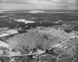
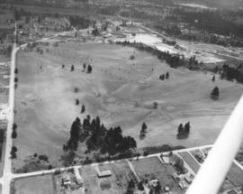
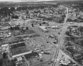
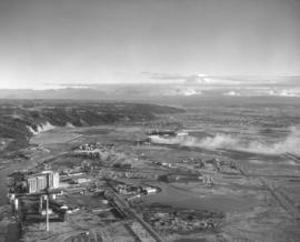
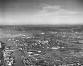
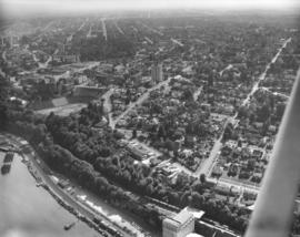
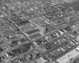
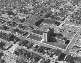
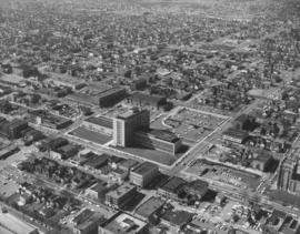
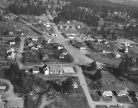
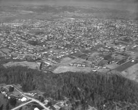
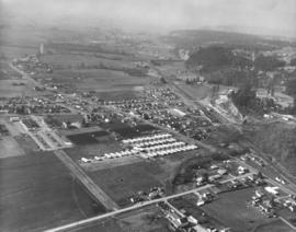
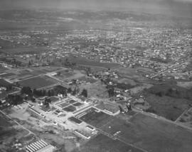
ca. 1961. Scenic views and stock files, 1961. Aerial photograph of city's north end including the Sixth Avenue, Orchard and Bantz Blvd (now Hwy. 16) areas. Cheney Stadium in upper left corner. Horizontal center street is Sixth Avenue with Orchard running vertically. Bantz Blvd. (now part of Hwy 16) is upper portion of photo, intersecting with Orchard. Thickly wooded terrain on Sixth Avenue is now (2004) filled with shopping malls, Kmart is across the street. Building near Sixth & Orchard is believed to be the First Christian Church directly across the street from Busch's Drive -In.


Aerial photographs; Neighborhoods--Tacoma--1960-1970; Streets--Tacoma--1960-1970;

D129800-68

ca. 1961. Aerial photograph of the Meadow Park Golf Course, taken for 1961 stock footage. Located at 7108 Lakewood Drive West, the Meadow Park Golf Course now offers 27 holes of golf on a well developed course lined with fir and oak trees.


Aerial photographs; Meadow Park Golf Course (Lakewood); Golf--Lakewood--1960-1970;

D129800-69

ca. 1961. Scenic views and stock footage, 1961. A closer aerial look at the Meadow Park Golf Course at 7108 Lakewood Dr. W. shows newly planted trees along with older firs and oaks. Meadow Park is now run under the auspices of Metro Parks. Shortly before Christmas, 1960, the wooden clubhouse at the golf course was destroyed by fire. According to Lakewood Fire Chief Bruce White, the loss totaled $50,000.


Aerial photographs; Meadow Park Golf Course (Lakewood); Golf--Lakewood--1960-1970;

D129800-75

ca. 1961. Tacoma-side view of the second Narrows Bridge; stock aerial footage, 1961. Mount Rainier rises majestically in the background overlooking the Narrows Bridge. Henry F. Hunt Junior High (now Middle School) with its unique mushroom-shaped cafeteria lies off the Sixth Avenue approach to the bridge on So. 10th St. Permission was granted to the Washington Pilots Assn. to reproduce this photograph in conjunction with its 1963 convention.


Aerial photographs; Tacoma Narrows Bridge (Tacoma); Suspension bridges--Tacoma; Henry F. Hunt Junior High School (Tacoma);

D129800-80

ca. 1961. Stock footage and scenic views, 1961. Port of Tacoma industrial landscape with Mount Rainier in background. Hylebos bridge extending over the Hylebos; 11th St. extends over the Port Industrial, Sitcum, Milwaukee and Puyallup Waterways. Log dumps near and in the Sitcum Waterway, probably for use by Tacoma Boatbuilding. TPL-10517


Aerial photographs; Port of Tacoma (Tacoma); Rainier, Mount (Wash.);

D130081-2

Tacoma's landscape in the 1960's would slowly be changing as nearly all of the vacant land and woods near the Sixth Avenue and Orchard area would be occupied by new homes and businesses. The tip of Cheney Stadium can be seen in the upper right hand corner. Busch's Drive-In is the long building with dark roof towards the center of the photograph; the bare area next door would become part of Kmart in the future. Boulevard Texaco service station is next to Busch's at the intersection of Sixth & Orchard. Across Sixth Avenue from Busch's is the relocated First Christian Church which was dedicated on February 19, 1961. The church had originally been located in downtown Tacoma since 1906; a new building was constructed at 6th & Orchard for $400,000. The large rectangular building with dark roof near the bottom right of the picture is believed to be Stebner's Inc, located at 5510 Sixth Ave. Stebner's was located two blocks west of Busch's and had celebrated its grand opening at that location on November 17, 1960. Photograph ordered by Busch's Sixth Avenue Drive-In.


Aerial photographs; Neighborhoods--Tacoma--1960-1970; Busch's Sixth Avenue Drive-In Restaurant (Tacoma); Boulevard Texaco (Tacoma); First Christian Church (Tacoma); Stebner's, Inc. (Tacoma);

D133100-14

This aerial view of the Lakewood Center shopping area was taken on December 2, 1961. The Villa Plaza Development Company specifically requested photographs that would show the large number of cars parked at the shopping center. Although the lots were not as vast as the nearby Villa Plaza Shopping Center, there was plenty of room for customers. Businesses in the foreground were Albertson's supermarket and a Standard Oil service station, two of the twenty eight stores and services offered at the shopping center. The Lakewood Center bordered Gravelly Lake Drive, Mt. Tacoma Dr. and Bridgeport Way. It was among the first of the country's one-stop shopping centers, and conveniently located 15 minutes from downtown Tacoma, five minutes from McChord and ten minutes from Fort Lewis.


Aerial photographs; Lakewood Community Center (Lakewood); Shopping centers--Lakewood--1960-1970; Parking lots--Lakewood;

D133276-1

ca. 1961. Aerial photograph of Tacoma Tideflats industrial area taken for inclusion in annual sample book. Clouds partially obscure Mount Rainier while heavy smoke pours over part of the Tideflats on a winter day in late 1961. Gravel pit on left with section of Browns Point in sight. Western Farmers Assn. feed mill is one of the tall buildings on left side of photograph alongside Hylebos Waterway.


Aerial photographs; Industrial facilities--Tacoma--1960-1970; Rainier, Mount (Wash.);

D133276-10

Closer look at Tideflat businesses via plane on January 9, 1962, for use in sample book. Educators Manufacturing Co. is on the left corner with dark roof, Western Farmers Assn. feed mill with large sign upper left. This is the busy intersection of Lincoln and Taylor Avenues. Hylebos Waterway in background next to gravel pit. A glimpse of Browns Point can be spotted beyond trees.


Aerial photographs; Industrial facilities--Tacoma--1960-1970; Hylebos Waterway (Tacoma);

D133276-2

ca. 1961. Aerial views taken in late 1961 of major manufacturers in the Tacoma Tideflats industrial area. Large building with loaf-shaped roof at left is Educators Mfg. Co., makers of school furniture, which had opened a new million dollar plant on Lincoln Avenue in 1958. Across the street are Reichhold Chemicals and Pennsalt. Hylebos Waterway is located next to the Western Farmers Assn. feed mill. Gravel pit and Browns Point area beyond the Hylebos.


Aerial photographs; Industrial facilities--Tacoma--1960-1970; Educators Manufacturing Co. (Tacoma);

D133276-3

ca. 1961. Additional close-up view of D133276-1, Tacoma Tideflats industrial area, ca. late 1961, looking toward Mount Rainier and Puyallup. Waterway to the left is the Hylebos; large building near it is the Western Farmers Assn. feed mill. Notable streets are Taylor and Lincoln. TPL-4740


Aerial photographs; Industrial facilities--Tacoma--1960-1970;

D133276-4

ca. 1961. Aerial views of Tacoma industrial area in late 1961. Large building in center with dark roof is the Educators Mfg. Co., exclusive makers of classroom cabinets, located on Lincoln Ave. The Educators Mfg. plant was built in 1958 on ten acres in the Tideflats. Western Farmers Assn. (formerly Washington Cooperative Egg & Poultry Association) feed mill on left, along the Hylebos Waterway. Gravel pit in background across the Hylebos.


Aerial photographs; Industrial facilities--Tacoma--1960-1970; Educators Manufacturing Co. (Tacoma);

D133276-5

ca. 1961. Aerial view of Tideflats area featuring Western Farmers Assn. feed mill along the Hylebos Waterway and buildings believed to belong to Buffelen Woodworking on Lincoln Ave. Photographs were taken in late 1961 for inclusion in a sample book.


Aerial photographs; Industrial facilities--Tacoma--1960-1970;

D133276-6

ca. 1961. Photograph of Tacoma's industrial area, the Tideflats, taken by plane in late 1961. Large ponds are left of the Educators Manufacturing Co. building. Western Farmers Assn. feed mill is tall building in photo's middle section. Part of Browns Point can be seen beyond gravel pit.


Aerial photographs; Industrial facilities--Tacoma--1960-1970;

D133276-7

View of Educators Manufacturing Co. million dollar plant, with dark roof, and Western Farmers Assn. feed mill taken via plane on January 9, 1962. Area includes other Tideflats businesses in the Taylor/Lincoln Avenue vicinity. Hylebos Waterway runs along the side of the feed mill. Photograph was included in the studio's annual sample book. TPL-2955


Aerial photographs; Industrial facilities--Tacoma--1960-1970;

D133276-9

Aerial photograph of the Tideflats taken in early January, 1962, for inclusion in sample book. Overview indicates still plenty of land for expansion in the city's industrial area. Logs peacefully bob in the Hylebos Waterway across from the Western Farmers Assn.(formerly Washington Cooperative Egg & Poultry Association) feed mill. Other businesses in the general vicinity of Taylor and Lincoln Avenues include Buffelen Woodworking and Reichhold Chemicals. TPL-2954


Aerial photographs; Industrial facilities--Tacoma--1960-1970; Hylebos Waterway (Tacoma);

D133281-1

View by air of downtown Tacoma business district, City (now Thea Foss) Waterway and part of the industrial Tideflats in December, 1961. 11th St. Bridge and St. Regis Paper Co. facilities in distance. Photograph ordered by Malcolm McGhie, industrial consultant, New York.


Aerial photographs; Industrial facilities--Tacoma--1960-1970; Commercial streets--Tacoma--1960-1970; City Waterway (Tacoma);

D133281-3

This is an aerial view of downtown Tacoma, City Waterway (now the Thea Foss Waterway) and industrial tideflats taken in December of 1961. Various bridges, including the 11th St. (now Murray Morgan Bridge) bridge, connect downtown to the mills and manufacturing concerns across the waterway. Plumes of smoke from St. Regis Paper Co. travel continuously across the bay as the plant ran multiple shifts. (scan from original negative, no print on file)


Aerial photographs; Aerial views; Cityscapes; Bridges--Tacoma--1960-1970; City Waterway (Tacoma); St. Regis Paper Co. (Tacoma)--1960-1970;

D133281-5

Aerial views of Tideflats industrial area, City (now Thea Foss) Waterway, and 11th St. Bridge on a clear winter day in 1961. Smoke puffs from several stacks of the St. Regis Paper Co. plant. Also in view is the St. Paul lumber yard. Masses of logs are floating along the City Waterway. Photograph ordered by Malcolm McGhie, industrial consultant, New York.


Aerial photographs; Industrial facilities--Tacoma--1960-1970; City Waterway (Tacoma);

D133300-188

Aerial photograph of Stadium High School area, stock footage, September 7, 1962. Stadium Bowl is clearly evident toward left-center of photograph with Stadium High School overlooking the massive field. Schuster Parkway will later be built through part of the wooded area to the left edge of picture. Trains roll through on two tracks with Ruston Way between them. TPL-9465


Aerial photographs; Stadium Bowl (Tacoma); Stadium High School (Tacoma); Neighborhoods--Tacoma--1960-1970;

D133300-19

ca. 1962. Aerial views, 1962 stock footage, of Tacoma Avenue South and vicinity. County-City Building is in center of photograph, new Tacoma Public Library Main branch along with Cargenie Library to its left. Central School is the eight-story Gothic structure to the County-City Building's right. Washington State Armory is behind parking lot (formerly location of the Pierce County Courthouse) of the County-City Building). TPL-8253


Aerial photographs; County-City Building (Tacoma); Tacoma Public Library (Tacoma); Central School (Tacoma); State Armory (Tacoma); Commercial streets--Tacoma--1960-1970;

D133300-22

ca. 1962. Aerial photography of So. 11th & Tacoma Ave. So. vicinity taken in 1962; stock footage. Large building with wings in center of photograph is the County-City Building which had opened just a few years previously. Directly across the street is the Main Library and the older Carnegie section. A large parking lot separates the County-City Building from the State Armory. The Tacoma Vocational Technical Institute (Bates) is at So. 11th & Yakima. Neighborhood toward upper portion of the picture is the Hilltop area.


Aerial photographs; County-City Building (Tacoma); Tacoma Public Library (Tacoma); State Armory (Tacoma); Tacoma Vocational School (Tacoma);

D133300-25

ca. 1962. Southwest view of County-City Building with Hilltop area in distance taken via plane in 1962, stock footage. Tacoma Public Library Main branch with Carnegie Library on left side. Central School is on edge of right side. Chevron station between the Central School and the County-City Building will later become location of McDonald's. Tacoma Vocational Technical Institute (Bates) is across from the State Armory on So. 11th St.


Aerial photographs; County-City Building (Tacoma); Tacoma Public Library (Tacoma); Central School (Tacoma); State Armory (Tacoma); Tacoma Vocational School (Tacoma);

D137300-100

ca. 1963. This is believed to be part of the city of Milton, taken by air ca. 1963. Large church and associated buildings in lower center. Some of the same features, including the two service stations toward upper portion, can be seen at a different angle in D137300-97.


Aerial photographs; Neighborhoods--Milton;

D137300-101

ca. 1963. 1963 aerial view looking northeast across the Puyallup Valley from the west hills. The meandering creek on the left just above the large section of forest in lower foreground has been identified as Clarke's Creek. The current DeCoursey/Clarke's Creek Park is the cleared area between the hill and creek. The roadway with the dogleg in it is 18th St. S.W. Puyallup in 1963 was a growing city of approximately 14,000 people. There were still farmlands in the vicinity but more and more houses were being built. (Additional identification and information provided by a reader)


Aerial photographs; Forests--Puyallup; Neighborhoods--Puyallup--1960-1970; Clarke's Creek (Puyallup);

D137300-102

ca. 1963. Mist obscures part of the background in this 1963 aerial photograph of the Puyallup Valley. Meridian is near the top portion of the picture and bridges the Milwaukee train tracks. The community of Edgewood is on the hill on the photograph's right side. North Puyallup is the community that lies inside the large "V" shaped by the Milwaukee tracks and Valley Avenue. (Additional information provided by a reader)


Aerial photographs; Streets--Puyallup;

D137300-104

ca. 1963. Looking toward the east, this aerial photograph taken in 1963 shows part of Puyallup. River Road is upper portion of photo; Pioneer is in middle of photograph. Western Washington Experiment Station is at the bottom of the photograph. (Additional information provided by Rick Oliver)


Aerial photographs; Neighborhoods--Puyallup--1960-1970;

D137300-105

ca. 1963. In 1963 several aerial photographs were taken by the Richards Studio of Pierce County with attention placed on the Puyallup region. This particular scene focuses on the lush farmlands with neatly plowed fields and rows of crops. In the distance can be seen the encroaching city of Puyallup. Puyallup in 1963 had a population of approximately 14,000 and would more than double that figure in forty years.


Aerial photographs; Croplands--Puyallup;

D137300-106

ca. 1963. Scenic view by air of the Edgewood area in 1963. Croplands are framed and bordered by stands of trees. More heavily populated areas in the far distance. This has been identified as the intersection of Meridian & 36th St. E. (additional information provided by a reader) TPL-9390


Aerial views; Neighborhoods--Edgewood;

D137300-107

ca. 1963. Aerial photographs of heavily wooded terrain interspersed with homes probably in the Milton/Edgewood/Puyallup region, taken in 1963.


Aerial photographs;

Results 241 to 270 of 824