Aerial Photography

Taxonomy

Code

Scope note(s)

Source note(s)

Display note(s)

Hierarchical terms

Aerial Photography

Equivalent terms

Aerial Photography

Associated terms

Aerial Photography

10 Collections results for Aerial Photography

10 results directly related Exclude narrower terms

D157659-2C

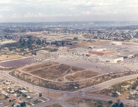
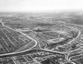
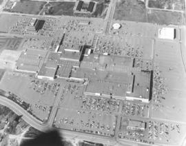
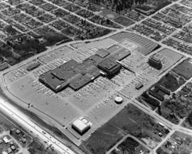
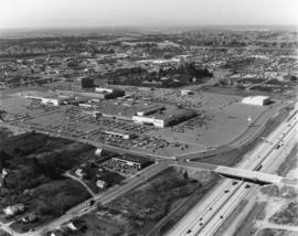
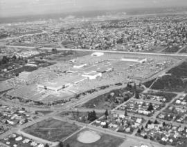
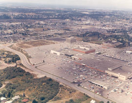
Aerial photograph of Tacoma Mall Shopping Center and vicinity in 1969. The area around the Tacoma Mall Shopping Center looked quite different in 1969 as the mall had not expanded to the size it holds in 2006. This view is taken looking across South 48th St. towards the mall with Penney's, Pay Less Drugs, and Nordstrom Best clearly visible. The Bon Marche (now Macy's) is the large red building in back of Nordstrom. The Tacoma Mall Office Building is off to its left and had recently opened. Best Buy and BabiesRus would later be built in the wooded area across So. 48th St. Pine St., which intersects So. 48th St., would later become more developed as the Post Office would build the Evergreen Station closer to So. 38th. The White Front store with large parking lot is already on So. 38th where Michael's would later be situated. In the distance toward the top center of the photograph is the Public Utilities building on So. 35th near Union Ave. Color photograph ordered by Center Offices, Inc.


Aerial views; Tacoma Mall Shopping Center (Tacoma); Shopping centers--Tacoma; Tacoma Mall Office Building (Tacoma); J.C. Penney Co. (Tacoma); Department stores--Tacoma--1960-1970; Pay Less Drugs (Tacoma); Nordstrom Best (Tacoma); White Front (Tacoma);

D157659-1C

Aerial view of Tacoma Mall Shopping Center and Tacoma Mall Office Building. This July, 1969, view of the popular Tacoma Mall Shopping Center and newly opened six-story Tacoma Mall Office Building shows that there is still much room for development of the center. New stores would be built on both sides of the Bon Marche (red building), first occupant of the mall. The dirt acreage bordering the parking lot would eventually become extended parking for the mall and the location of Frederick & Nelson's. The Post Office would build its Evergreen Station also on Pine Street, just beyond the left edge of the photograph. Color photograph ordered by Center Offices, Inc.


Aerial views; Tacoma Mall Shopping Center (Tacoma); Shopping centers--Tacoma; Tacoma Mall Office Building (Tacoma); Parking lots--Tacoma--1960-1970; Bon Marche (Tacoma);

D163162-7

Aerial view on April 2, 1973, of the Nalley Valley and 38th St. interchange. Atlas Foundry is on the right side. The Tacoma Mall is left-center, adjacent to the freeway. There were a variety of ways to get to the Mall, including the heavily utilized South Pine and South 38th St. entrances. Less than nine years old and already boasting of several large department stores as well as specialty shops, the Mall was able to draw a shopping population from as far south as Olympia and from as far north as Seattle. Photograph ordered by Puget Sound National Bank.


Aerial views; Neighborhoods--Tacoma--1970-1980; Tacoma Mall Shopping Center (Tacoma); Shopping centers--Tacoma--1970-1980; Express highways--Tacoma--1970-1980;

D163162-24

Another in a series of aerial photographs taken on April 2, 1973, for Puget Sound National Bank regarding the Tacoma Mall and surrounding areas. The hundreds of automobiles in the parking lot appear the size of matchbox cars when viewed via helicopter on this sunny spring day. Parking was obviously no problem and the weather would not be a factor either, since the Tacoma Mall was an enclosed, climate-controlled shopping center. J.C. Penney, the Bon Marche, Nordstrom and the soon-to-be constructed Rhodes department store on the west side would be the four major stores anchoring the Mall. Separate buildings in the Mall area included (l-r)the Tacoma Mall Office Building, the Bon Marche Tire Center, the round Pacific National Bank of Washington and the Tacoma Mall Theatre.


Aerial views; Parking lots--Tacoma--1970-1980; Tacoma Mall Shopping Center (Tacoma); Shopping centers--Tacoma--1970-1980; Tacoma Mall Office Building (Tacoma); Tacoma Mall Theater (Tacoma); Pacific National Bank of Washington (Tacoma);

D163162-21

Closer look at the Tacoma Mall Shopping Center as seen by air on April 2, 1973. 25 more stores would open on July 25th bringing the total number of stores found within the Mall to 110. Construction would begin soon on the two-story Rhodes Bros. department store at the far west end. Prominent buildings easily noted in this photograph are the Bon Marche, which was the first occupant of the Mall; the luxurious Tacoma Mall Theatre (bottom center); Pacific National Bank of Washington's circular building; the Bon Marche Tire Center, directly across from the Bon and the six-story Tacoma Mall Office Building. What the Tacoma Mall enjoyed, and downtown shopping lacked, was an abundance of free parking and a climate controlled atmosphere. Access to the Mall was easy with several entrances and quick freeway travel time. The wooded area across the Mall on South 48th St. would eventually become Best Buy, a Pierce County Transit Center, and closer to Pine St., the Social Security office. Ordered by Puget Sound National Bank.


Aerial views; Tacoma Mall Shopping Center (Tacoma); Shopping centers--Tacoma--1970-1980; Parking lots--Tacoma--1970-1980; Bon Marche (Tacoma); Tacoma Mall Theater (Tacoma); Pacific National Bank of Washington (Tacoma); Tacoma Mall Office Building (Tacoma)

D163162-22

Aerial view of Tacoma's largest shopping center, the Tacoma Mall, on April 2, 1973. Traffic on I-5 flows quickly along and there was easy access to the shopping center. South 48th St. with its overpass over I-5 intersects with South Ferry at the Mall. The Allstate Insurance Co.district office is the large building at the southwest corner of South 48th & Ferry. The wooded area next to Allstate would later be developed. This view, looking north, shows the Mall in its entirety, including the separate structures of the Tacoma Mall Theatre, Pacific National Bank of Washington, and the Tacoma Mall Office Building. With 83 acres of land, there was plenty of room for free parking and also for later expansion. Rhodes department store had already announced plans to open a branch at the Mall; it would be built on the extreme far west section. This aerial also shows the Mall's surrounding neighborhoods including Lincoln Heights off 38th St. past the grove of evergreens. Photograph ordered by Puget Sound National Bankl.


Aerial views; Tacoma Mall Shopping Center (Tacoma); Shopping centers--Tacoma--1970-1980; Express highways--Tacoma--1970-1980; Allstate Insurance Co. (Tacoma); Tacoma Mall Theater (Tacoma); Tacoma Mall Office Building (Tacoma);

D163162-5

The focus of this April, 1973, aerial is the Tacoma Mall Shopping Center and its environs. Located in the city's south end, the Tacoma Mall enjoyed easy access from the freeway and acres of free parking space. Customers could choose from about 100 stores, all under one climate-controlled roof. Rhodes Bros. would be the next large department store to open in the newly expanded Mall, a move that would eventually mean the closing of its flagship downtown location in late 1974. This view, looking east, also shows South Tacoma Way at the bottom. Photograph ordered by Puget Sound National Bank.


Aerial views; Neighborhoods--Tacoma--1970-1980; Tacoma Mall Shopping Center (Tacoma); Shopping centers--Tacoma--1970-1980; Express highways--Tacoma--1970-1980;

D164600-105C

1974 Richards stock footage. Construction of the new Liberty House/Rhodes department store at the Tacoma Mall is proceeding rapidly during the spring of 1974. The two-story building is being built at the Mall's far west end for an estimated $2,000,000. There would be 128,093 square feet of floor space. The store was scheduled to open in the fall of 1974. Also included in this May, 1974, aerial view of the shopping center: the Tacoma Mall Office Building (in rear), the 10-month old west end addition to the Mall, Nordstrom, and the Bon Marche. (TNT 1-13-74, F-8 article)


Aerial views; Aerial photographs; Tacoma Mall Shopping Center (Tacoma); Shopping centers--Tacoma--1970-1980; Building construction--Tacoma--1970-1980; Tacoma Mall Office Building (Tacoma); Bon Marche (Tacoma); Liberty House (Tacoma);

D164600-104C

1974 Richards stock footage. A look at the Tacoma Mall by air in the spring of 1974 shows that the Mall continues to grow with the building of the new Liberty House/Rhodes department store at the Mall's extreme west end. The store was scheduled to open that fall. I-5 runs nearly vertically at the photograph's right, allowing easy access to the shopping center. The wooded area east of the freeway would eventually be dotted with new homes; businesses would also take the place of the homes located at the bottom of the photograph.


Aerial views; Aerial photographs; Tacoma Mall Shopping Center (Tacoma); Shopping centers--Tacoma--1970-1980; Neighborhoods--Tacoma--1970-1980; Express highways--Tacoma--1970-1980;

D164600-101

1974 Richards stock footage. Aerial view of the Tacoma Mall and surrounding south end neighborhoods. This May, 1974, view by air makes it plain that one of the main attributes of this popular shopping center was its ready access by freeway and its enormous free parking lots. Should a visitor to the Mall decide to bypass the freeway, the Mall would still be accessible through well traveled local streets such as Pine, South 38th and South 48th. The Mall had opened its west end addition in July of 1973 to add 20 more stores to the shopping center; in May of 1974, construction was proceeding rapidly with the new Liberty House/Rhodes department store at the far west end of the shopping center. TPL-5876


Aerial views; Aerial photographs; Tacoma Mall Shopping Center (Tacoma); Shopping centers--Tacoma--1970-1980; Express highways--Tacoma--1970-1980; Neighborhoods--Tacoma--1970-1980;