Aerial Photography

Taxonomy

Code

Scope note(s)

Source note(s)

Display note(s)

Hierarchical terms

Aerial Photography

Equivalent terms

Aerial Photography

Associated terms

Aerial Photography

824 Collections results for Aerial Photography

824 results directly related Exclude narrower terms

D163162-21

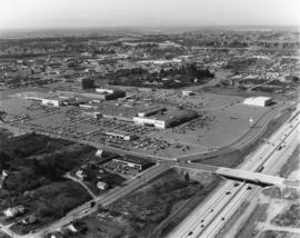
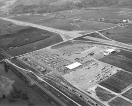
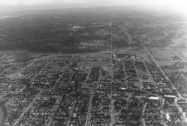
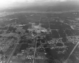
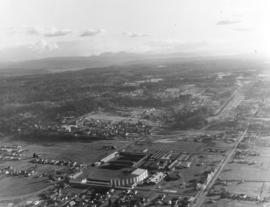
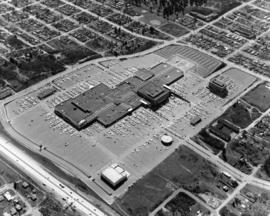
Closer look at the Tacoma Mall Shopping Center as seen by air on April 2, 1973. 25 more stores would open on July 25th bringing the total number of stores found within the Mall to 110. Construction would begin soon on the two-story Rhodes Bros. department store at the far west end. Prominent buildings easily noted in this photograph are the Bon Marche, which was the first occupant of the Mall; the luxurious Tacoma Mall Theatre (bottom center); Pacific National Bank of Washington's circular building; the Bon Marche Tire Center, directly across from the Bon and the six-story Tacoma Mall Office Building. What the Tacoma Mall enjoyed, and downtown shopping lacked, was an abundance of free parking and a climate controlled atmosphere. Access to the Mall was easy with several entrances and quick freeway travel time. The wooded area across the Mall on South 48th St. would eventually become Best Buy, a Pierce County Transit Center, and closer to Pine St., the Social Security office. Ordered by Puget Sound National Bank.


Aerial views; Tacoma Mall Shopping Center (Tacoma); Shopping centers--Tacoma--1970-1980; Parking lots--Tacoma--1970-1980; Bon Marche (Tacoma); Tacoma Mall Theater (Tacoma); Pacific National Bank of Washington (Tacoma); Tacoma Mall Office Building (Tacoma)

D163162-22

Aerial view of Tacoma's largest shopping center, the Tacoma Mall, on April 2, 1973. Traffic on I-5 flows quickly along and there was easy access to the shopping center. South 48th St. with its overpass over I-5 intersects with South Ferry at the Mall. The Allstate Insurance Co.district office is the large building at the southwest corner of South 48th & Ferry. The wooded area next to Allstate would later be developed. This view, looking north, shows the Mall in its entirety, including the separate structures of the Tacoma Mall Theatre, Pacific National Bank of Washington, and the Tacoma Mall Office Building. With 83 acres of land, there was plenty of room for free parking and also for later expansion. Rhodes department store had already announced plans to open a branch at the Mall; it would be built on the extreme far west section. This aerial also shows the Mall's surrounding neighborhoods including Lincoln Heights off 38th St. past the grove of evergreens. Photograph ordered by Puget Sound National Bankl.


Aerial views; Tacoma Mall Shopping Center (Tacoma); Shopping centers--Tacoma--1970-1980; Express highways--Tacoma--1970-1980; Allstate Insurance Co. (Tacoma); Tacoma Mall Theater (Tacoma); Tacoma Mall Office Building (Tacoma);

D163162-5

The focus of this April, 1973, aerial is the Tacoma Mall Shopping Center and its environs. Located in the city's south end, the Tacoma Mall enjoyed easy access from the freeway and acres of free parking space. Customers could choose from about 100 stores, all under one climate-controlled roof. Rhodes Bros. would be the next large department store to open in the newly expanded Mall, a move that would eventually mean the closing of its flagship downtown location in late 1974. This view, looking east, also shows South Tacoma Way at the bottom. Photograph ordered by Puget Sound National Bank.


Aerial views; Neighborhoods--Tacoma--1970-1980; Tacoma Mall Shopping Center (Tacoma); Shopping centers--Tacoma--1970-1980; Express highways--Tacoma--1970-1980;

D163162-13

Northwest view from South 84th & Park Ave. This aerial look at Tacoma's south side was taken on behalf of Puget Sound National Bank on April 2, 1973. Lake in the center is Wapato Lake, bordered by South Alaska, South 72nd and Sheridan Ave. John S. Baker Junior High (now Middle School) is near bottom-center. Park Ave. has been marked in ink. Yakima Ave. is parallel to Park and is left of Park.


Aerial views; Neighborhoods--Tacoma--1970-1980; Wapato Lake (Tacoma); Baker Junior High School (Tacoma);

D163162-15

Looking west from South 56th & Pacific Ave. Aerial view on April 2, 1973, of the densely populated area around the Tacoma Mall. The Mall itself is right-center. Olympics are at the top of the photograph. Photograph ordered by Puget Sound National Bank.


Aerial views; Neighborhoods--Tacoma--1970-1980; Tacoma Mall Shopping Center (Tacoma); Shopping centers--Tacoma--1970-1980;

D163000-111C

1973 Richards stock footage. Aerial view of shipyard believed to be Tacoma Boatbuilding Co. taken on a clear February day in 1973. Masses of logs float nearby until needed. The shipyard faces the Hylebos Waterway and was moved there after Tacoma Boatbuilding's longtime plant on the Sitcum Waterway was destroyed by fire in 1968.


Aerial views; Boat & ship industry--Tacoma--1970-1980; Tacoma Boat Building Co., Inc. (Tacoma); Logs; Hylebos Waterway (Tacoma);

D163000-415C

ca. 1973. 1973 Richards stock footage. Aerial photograph, probably taken in the fall of 1973, of the St. Regis Paper Co. The plant, the county's largest non-military employer, was located between the Puyallup and St. Paul Waterways. St. Regis would be acquired by Champion International Corp. in 1984 and subsequently sold to Simpson Tacoma Kraft the following year. Simpson Tacoma Kraft still maintains the plant in 2007.


Aerial views; St. Regis Paper Co. (Tacoma)--1970-1980; Puyallup Waterway (Tacoma); St. Paul Waterway (Tacoma);

D163000-135C

ca. 1973. 1973 Richards stock footage. Unidentified ships docked at Port of Tacoma, as seen by air, in 1973. The Port, then as now, was a busy, bustling place which saw the arrival and departure of many ships during the year.


Aerial views; Vessels; Port of Tacoma (Tacoma);

D163000-116C

ca. 1973. 1973 Richards stock footage. A look by air at the shipyard believed to be Tacoma Boatbuilding, located at 1840 Marine View Dr. N.E., overlooking the Hylebos Waterway. Built on a spacious 20-acre site in 1969, the shipyard was able to expand production of extra-large fishing boats as well as complete government contracts. Tacoma Boatbuilding had decided to move operations to this Hylebos Waterway location after fire had destroyed their plant on the Sitcum Waterway in 1968.


Aerial views; Boat & ship industry--Tacoma--1970-1980; Tacoma Boat Building Co., Inc. (Tacoma); Logs; Hylebos Waterway (Tacoma);

D163000-114C

ca. 1973. 1973 Richards stock footage. Closer aerial look at shipyard on the Hylebos Waterway, believed to be Tacoma Boatbuilding who had constructed a $3,000,000 plant there after the disastrous fire of 1968 which had destroyed their Sitcum Waterway facility. The Hylebos location now provided 20 acres of space and held separate buildings for aluminum fabricating, steel fabricating, administrative and engineering, and warehouse for equipment. Several boats are pictured above docked at the 300-foot pier. TPL-6583


Aerial views; Boat & ship industry--Tacoma--1970-1980; Tacoma Boat Building Co., Inc. (Tacoma); Hylebos Waterway (Tacoma); Logs; Piers & wharves--Tacoma--1970-1980;

D163000-105C

ca. 1973. 1973 Richards stock footage. This may be the 712-foot long tanker, "Achilles," as seen by air, docked at the Port of Tacoma in 1973. She appears to be ready to take on grain from the port's grain elevator. Other unidentified vessels are in the background.


Aerial views; Vessels; Piers & wharves--Tacoma--1970-1980;

D163000-328C

ca. 1973. 1973 Richards stock footage. An overhead view of the American Smelting & Refining Co. (ASARCO) and Commencement Bay in 1973. Wispy puffs of smoke emerge from the plant's 562-foot smokestack. ASARCO would eventually close twelve years later due to economic and environmental reasons. The smelter stack was demolished in 1993.


Aerial views; American Smelting & Refining Co. (Tacoma); Smelters--Tacoma--1970-1980; Smokestacks--Tacoma; Industrial facilities--Tacoma; Commencement Bay (Wash.);

D163000-329C

ca. 1973. 1973 Richards stock footage. Aerial view of North 52nd St. area, featuring the American Smelting & Refining Co. (ASARCO) plant and smokestack. Also in the photograph is winding Bayshore Drive near Commencement Bay. The tip of Mount Rainier can barely be seen in the background haze.


Aerial views; American Smelting & Refining Co. (Tacoma); Smokestacks--Tacoma; Commencement Bay (Wash.); Rainier, Mount (Wash.);

D163000-326C

ca. 1973. 1973 Richards stock footage. This aerial view features the two large domes leased by Kaiser Aluminum from the Port of Tacoma. The aluminum sheathed domes stored shipments of alumina ore from Australia. Both domes were eventually dismantled about 2005.


Aerial views; Storage tanks--Tacoma; Kaiser Aluminum & Chemical Corp. (Tacoma); Port of Tacoma (Tacoma);

C163175-1C

ca. 1973. Copy of customer print ordered on April 5, 1973, by Tacoma Boatbuilding. Colorful aerial view of Tacoma Boatbuilding's 20-acre plant on the Hylebos Waterway. Three cargo ships, including the "Atlantis," are in port. Tacoma Boatbuilding had moved to 1840 Marine View Dr. N.E. in 1969 after fire had destroyed their longtime Sitcum Waterway plant.


Aerial views; Tacoma Boat Building Co., Inc. (Tacoma); Boat & ship industry--Tacoma--1970-1980; Cargo ships--Tacoma; Hylebos Waterway (Tacoma);

D162638-10C

This is the Kaiser Aluminum plant in the tideflats as seen by air during the fall of 1972. The 500-foot smokestack was built in 1968 during plant expansion. Photograph taken on speculation.


Aerial views; Kaiser Aluminum & Chemical Corp. (Tacoma); Aluminum industry--Tacoma--1970-1980; Smokestacks--Tacoma;

D162638-2C

Smoke pours from the 500-foot smokestack at the Kaiser Aluminum plant, 3400 Taylor Way, on October 12, 1972. The company had undergone expansion in the late 1960s and built a new aluminum rod mill and second aluminum dome in addition to the smokestack. Kaiser Aluminum would permanently close in 2002 and the smokestack demolished four years later.


Aerial views; Kaiser Aluminum & Chemical Corp. (Tacoma); Aluminum industry--Tacoma--1970-1980; Smokestacks--Tacoma;

D161890-3

Aerial view of Kent-based Convoy Co. taken on May 1, 1972. Massive parking lot with hundreds of cars, easy access to major roadways. Railroad cars parked next to facility, many loaded with automobiles. Convoy Co. was located in Kent at 27430 - So. 72nd. Photograph ordered by the Convoy Co.


Aerial views; Convoy Co. (Kent); Automobiles--Kent;

D161273-30

This is possibly Thun Field, just south of the City of Puyallup in the South Hill neighborhood. The air field appears to be hemmed in by tall firs. Photograph taken on January 2, 1972; ordered by Puget Sound National Bank.


Aerial views; Airports;

D161273-12

One of a series of photographs taken by air on January 2, 1972, of the Puyallup-area neighborhoods of 112th & Meridian and vicinity. Tall evergreens blanket the area with a few homes carved out of the forests. Photograph ordered by Puget Sound National Bank.


Aerial views; Neighborhoods--Puyallup--1970-1980;

D161273-19

Another in a series of photographs taken by air on January 2, 1972, of the Meridian South & 112th St. neighborhoods. The landscape would change in the following years as the area started to expand. Photograph ordered by Puget Sound National Bank.


Aerial views; Neighborhoods--Puyallup--1970-1980;

D161273-26

View by air of the area around 112th & Meridian near Puyallup. This was taken on January 2, 1972, on behalf of Puget Sound National Bank.


Aerial views; Neighborhoods--Puyallup--1970-1980;

D161273-7

This is an aerial of roughly the future location of the South Hill Mall area in January of 1972. Running vertically in the center of the photograph is 112th St. Meridian is the street that intersects 112th. Other than the cluster of homes on the left, much of the area is still very rural and wooded. Photograph ordered by Puget Sound National Bank.


Aerial views; Neighborhoods--Puyallup--1970-1980;

D161273-16

Aerial view of Puyallup Valley taken on January 2, 1972. This is roughly around the Meridian South vicinity; nestled among tall firs is a water tower visible at bottom of photograph. Photograph ordered by Puget Sound National Bank.


Aerial views; Neighborhoods--Puyallup--1970-1980; Water towers--Puyallup;

D161273-13

Aerial view of the Puyallup neighborhoods taken in January of 1972; the Western Washington Fairgrounds are located at Meridian South and 9th Ave. S.W. near center-right. Acres of trees at upper left-center. Photograph ordered by Puget Sound National Bank.


Aerial views; Neighborhoods--Puyallup--1970-1980; Western Washington Fair (Puyallup);

D161273-15

This aerial view of the Puyallup neighborhoods near 112th & Meridian was taken by the Richards Studio on January 2, 1972, on behalf of Puget Sound National Bank. Sand and gravel pit on the left; sprinkling of homes and businesses nearby.


Aerial views; Neighborhoods--Puyallup--1970-1980;

D161273-2

Another in a series of aerials of the area around 112th & Meridian in early 1972. In the late 1980s, the South Hill Mall would be built about this location. Photograph ordered by Puget Sound National Bank.


Aerial views; Neighborhoods--Puyallup--1970-1980;

D161273-24

This is what the 112th & Meridian area looked like in early 1972. The South Hill Mall would be built 16 years later on Meridian. What is noticeable is the large amount of woods and relatively few homes. Aerial photograph ordered by Puget Sound National Bank.


Aerial views; Neighborhoods--Puyallup--1970-1980;

D161273-5

The 112th & Meridian neighborhoods as seen by air in January of 1972. At that time there was an abundance of wooded acreage and not many homes. Photograph ordered by Puget Sound National Bank.


Aerial views; Neighborhoods--Puyallup--1970-1980;

D161273-20

Closer view of Puyallup neighborhood about 9th Ave. S.W. and Meridian South with Western Washington Fairgrounds in lower center. This photograph, one of a series, was taken on January 2, 1972, on behalf of Puget Sound National Bank.


Aerial views; Neighborhoods--Puyallup--1970-1980; Western Washington Fair (Puyallup);

Results 61 to 90 of 824