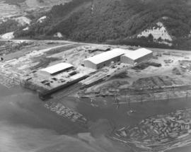
Aerial Photography

Taxonomy

Code

Scope note(s)

Source note(s)

Display note(s)

Hierarchical terms

Aerial Photography

Equivalent terms

Aerial Photography

Associated terms

Aerial Photography

824 Collections results for Aerial Photography

824 results directly related Exclude narrower terms

D157046-8

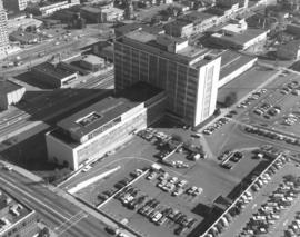
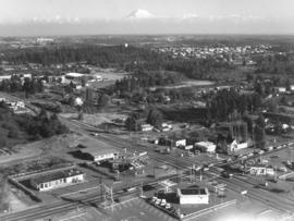
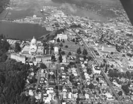
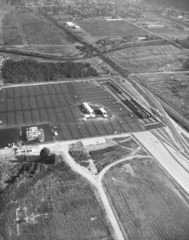
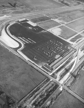
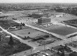
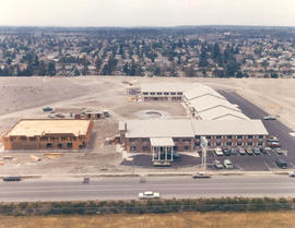
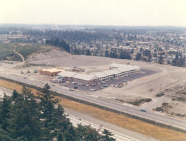
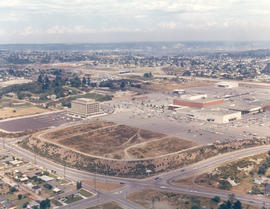
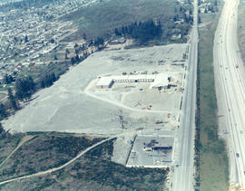
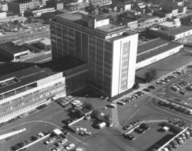
October 4, 1969, aerial view of County-City Building, location of city, county, police and court systems. This view captures the rear portion of the County-City Building and shows the large parking lot available. Somewhat resembling an airplane with extended wings, the County-City Building was formally dedicated in April of 1959. It occupied land between So. 9th & So. 11th Street on Tacoma Ave. So. The old Gothic-styled Pierce County Courthouse had been demolished and services transferred to the new building; parking for the County-City Building would take its place. Although the County-City Building was only ten years old in 1969, it was already bursting at its seams. Supporters had proposed to the City Council in late September, 1969, that an $8 million dollar bond issue for a new 5-story wing be considered. The courts needed more space so that trials could proceed without delays. Horace J. Whitacre of Whitacre Engineers gave a detailed projection of the County-City Building's future space needs. Photograph ordered by Whitacre Engineers. (TNT 9-23-69 , p. 10- article)


Aerial views; County-City Building (Tacoma); Parking lots--Tacoma--1960-1970;

D157050-7

Aerial view of new Tacoma Boatbuilding plant and log dumps on the Hylebos Waterway. The new facility would replace the longtime plant on the Sitcum Waterway which had been gutted by fire in 1968. The L-shaped structrure nearest to Marine View Dr. roadway is believed to hold the administrative and engineering offices. The largest building in this October 4, 1969, photograph is the aluminum fabricating plant, flanked by the steel fabricating building. The building nearest the water is the trades building which holds the equipment used by pipefitters and electricians. A 300-foot pier is being constructed next to 350-foot double ways. With 20 acres of land, the plant had plenty of room for further expansion if needed. Photograph ordered by Tacoma Boatbuilding. (TNT full page ad 10-10-69, A-20; TNT 10-19-69, D-10)


Aerial views; Boat & ship industry--Tacoma--1960-1970; Tacoma Boat Building Co., Inc. (Tacoma); Logs; Hylebos Waterway (Tacoma);

D157046-4

County-City Building. Aerial view looking south on Tacoma Ave. So. with close-up of side and rear of County-City Building, its large parking lot, and Tacoma Public Library across the street. The County-City Building had been completed in 1959 to replace the venerable Old City Hall, 625 Commerce St. Ten years later it housed both city and county offices, including the health department, auditor, assessor, sheriff and city police, city council & mayor, county commissioners and courts. The future would see many of these departments move to separate buildings including the Municipal Building (formerly the Medical Arts Building), Pierce County Annex and the new Tacoma Police Department's complex on Pine St. Photograph ordered by Whitacre Engineers.


Aerial views; County-City Building (Tacoma); Tacoma Public Library (Tacoma); Public libraries--Tacoma--1960-1970; Parking lots--Tacoma--1960-1970; Commercial streets--Tacoma--1960-1970;

D157046-1

Aerial view of County-City Building and vicinity on a clear early October day in 1969. The County-City Building had celebrated its 10th birthday in 1969, having replaced the dilapidated Old City Hall on Commerce. It is the multi-story aluminum and glass building on Tacoma Ave. So. in the center of the photograph; one of its wings visible is the reinforced concrete court building. To the south of the County-City Building is the Tacoma Public Library; the Carnegie Library, now home to the library's Northwest Room & Special Collections, is the rounded Renaissance-styled structure. West of the County-City Building is the Washington National Guard Armory at 11th & Yakima; across the street from the Armory is the (now) L.H. Bates Vocational-Technical Institute. This view looks much the same now in 2006 as it did 37 years ago. Photograph ordered by Whitacre Engineers. TPL-9648


Aerial views; County-City Building (Tacoma); Tacoma Public Library (Tacoma); Public libraries--Tacoma--1960-1970; Tacoma Vocational School (Tacoma); State Armory (Tacoma); Commercial streets--Tacoma--1960-1970;

D156922-7

Mount Rainier peeks over the University Place neighborhood of 27th & Bridgeport Way W. in the fall of 1969. University Place water tower can be seen left-center in the midst of trees in this aerial view. Safeway's large supermarket (center of photograph) is at 7520 - 27th St. W. in a small shopping center. Also located there are Thrifty Drugs and Value Stores. Photograph ordered by Jack Baty & Associates.


Aerial views; Neighborhoods--University Place--1960-1970; Safeway Stores, Inc. (University Place);

D156922-8

Closer September, 1969, northwest to southeast aerial view of intersection of 27th W. and Bridgeport in University Place. (see D156922, image 7 for extended view) This now busy intersection was still fairly undeveloped in 1969; there are a few businesses including the Park & Shop market at 26th & Bridgeport (parking lot visible at bottom) and several service stations--Paul's Chevron, University Place Shell around 27th & Bridgeport. University Place water tower can barely be seen in upper center of photograph amidst the towering trees. The cap of Mount Rainier forms a beautiful background. Photograph ordered by Jack Baty & Associates.


Aerial views; Neighborhoods--University Place--1960-1970; Automobile service stations--University Place;

D155600-213C

1969 Richards stock footage. Colorful aerial view of Cheney Port Mill, Inc., and Glacier Sand & Gravel located on the Tideflat's Taylor Way in the fall of 1969. The Cheney saw mill had previously been located at 501 Port of Tacoma Rd. before relocating to 3825 Taylor Way. Glacier's large lot has mounds of sand and/or gravel on the premises; there is also a conveyor system in place near the Taylor Way entrance. Glacier Sand & Gravel, 3601 Taylor Way, specialized in ready mix concrete. Both companies adjoin the Hylebos Waterway.


Aerial views; Glacier Sand & Gravel Co. (Tacoma); Cheney Port Mill, Inc. (Tacoma); Building materials industry--Tacoma--1960-1970; Lumber industry--Tacoma--1960-1970; Sawmills--Tacoma--1960-1970; Hylebos Waterway (Tacoma);

D155600-215C

1969 Richards stock footage. Color aerial photograph of Marymount Military Academy, the only military school in Washington State; photograph taken in September of 1969. Built in 1922, the school was operated by the Dominican Sisters, a Catholic teaching order, and enrollment limited to boys 6-16. The school closed in 1976 due to insufficient enrollment and higher operating costs. In the 1980's, Harold LeMay would purchase the 80-acre property which would house much of his collection, the largest privately owned collection of automobiles in the world. Each August for the last 25 years, the LeMays have drawn thousands to the car show and open house at the former Marymount Academy. TPL-9104 (www.lemaymuseum.org)


Aerial views; Marymount Military Academy (Spanaway); Private schools--Spanaway; Military education--Spanaway;

D155600-216C

1969 Richards stock footage. Parkland neighborhood featuring Pacific Lutheran University, Garfield St. and Pacific Avenue as viewed by air in September of 1969. Fall has come to the Pacific Northwest as yards have browned and the trees other than the numerous firs will soon lose their leaves. Looking west from Pacific Ave near the bottom of the photograph is the neighborhood around Pacific Lutheran University. Piggly Wiggly has a supermarket which is at the intersection of Garfield and Pacific; its large letters are clearly visible from the air. To the grocery store's right is believed to be Parkland Lutheran Church & School with its playground behind it. Pacific Lutheran University's upper campus buildings, surrounded by tall firs, are clustered in the center of the picture. Portions of McChord AFB can hazily been seen at the top of the photograph.


Aerial views; Pacific Lutheran University (Parkland)--1960-1970; Neighborhoods--Parkland; Piggly Wiggly (Parkland);

D155600-211C

1969 Richards stock footage. Autumn view of Kaiser Aluminum plant in tideflats taken by air in 1969. Located on Taylor Way approximately five miles north of downtown Tacoma, the large Kaiser facility had expanded in late 1968 to manufacture aluminum rods for shipment to California for finishing into electrical conductors. 1969 would see further expansion as its second alumina dome with a 100,000 ton capacity was completed on Pier 7.


Aerial views; Kaiser Aluminum & Chemical Corp. (Tacoma); Aluminum industry--Tacoma--1960-1970;

D156904-4

Aerial views of the City of Olympia requested by Puget Sound National Bank. Olympia, the state capital, is located at the head of Budd Inlet in the northern part of Thurston County. It was officially platted in 1850 by settler Edmund Sylvester who laid out a town in the New England style with town square, tree lined streets, Masonic Hall, land for schools and capitol grounds. The grand domed Legislative Building overlooking Capitol Lake was completed in 1927. It was damaged in the April, 1949, earthquake and later in the 1965 earthquake but was repaired and reinforced. The bridge to the right of the capitol buildings was heavily damaged in the earthquake of 2001. (www.ci.olympia.wa.us/information/history)


Aerial views; Legislative Building (Olympia); Streets--Olympia--1960-1970; Capitol Lake (Olympia);

D156904-3

Aerial photographs of the City of Olympia in the fall of 1969. View of the Port of Olympia. Olympia, the state capital, had a population then of about 23,000. As the above aerial indicates, there was still plenty of room for growth with acres of uncut timber. Located about 30 miles south of Tacoma, Olympia was named provisional territorial capital in 1853 by Isaac Stevens, Washington's first territorial governor. The name of the city was chosen by local resident Isaac Ebey to commemorate the view of the majestic Olympic Mountains. (www.ci.olympia.wa.us/information/history) Photograph ordered by Puget Sound National Bank.


Aerial views; Port of Olympia (Olympia);

D156904-5

State capitol and grounds. Aerial view looking north on September 5, 1969, of the City of Olympia focusing on the domed Legislative Building and surrounding grounds. Body of water is Capitol Lake. Neatly lined streets are a blend of businesses and large homes. Long road east of the capitol grounds is Capitol Way. Sylvester Park is clump of woods adjacent to Capitol Way. Photograph requested by Puget Sound National Bank.


Aerial views; Streets--Olympia--1960-1970; Legislative Building (Olympia); Capitol Lake (Olympia);

D157008-2

New automobile unloading complex. September, 1969, aerial view of a portion of the new Milwaukee Road Union Pacific yard in Kent designed by Tacoma architects and engineers, Siefert, Forbes & Berry. The multi-million dollar complex was scheduled for dedication on October 1, 1969. Easy access from the facility was provided by the Valley Freeway and 277th St. Photograph ordered by the Milwaukee Road. (TNT 10-1-69, A-17)


Aerial views; Shipping--Kent; Railroad tracks--Kent;

D157008-10

Aerial view of new automobile unloading complex. The Milwaukee and Union Pacific were scheduled to dedicate a multi-million dollar automobile unloading complex near Kent on October 1, 1969. Highway upper portion is the Valley Freeway; road that is diagonal is 277th St. Only one of the unloading facilities is in view in the paved section. Photograph ordered by the Milwaukee Road. (TNT 10-1-69, A-17)


Aerial views; Shipping--Kent; Railroad tracks--Kent; Express highways--Kent;

D156779-18

Aerials of Brookdale area around Brookdale Golf Course, Chesney Rd. E., Givens Rd. E., and Waller Rd. E. taken on August 18, 1969. The Brookdale Golf Course was built in 1931 and offered its patrons fine views of Mount Rainier while striding the par-71, 6400-yard course. Photograph ordered by Healy Bros.


Aerial views; Aerial photographs; Brookdale Golf Club (Parkland);

D157659-2C

Aerial photograph of Tacoma Mall Shopping Center and vicinity in 1969. The area around the Tacoma Mall Shopping Center looked quite different in 1969 as the mall had not expanded to the size it holds in 2006. This view is taken looking across South 48th St. towards the mall with Penney's, Pay Less Drugs, and Nordstrom Best clearly visible. The Bon Marche (now Macy's) is the large red building in back of Nordstrom. The Tacoma Mall Office Building is off to its left and had recently opened. Best Buy and BabiesRus would later be built in the wooded area across So. 48th St. Pine St., which intersects So. 48th St., would later become more developed as the Post Office would build the Evergreen Station closer to So. 38th. The White Front store with large parking lot is already on So. 38th where Michael's would later be situated. In the distance toward the top center of the photograph is the Public Utilities building on So. 35th near Union Ave. Color photograph ordered by Center Offices, Inc.


Aerial views; Tacoma Mall Shopping Center (Tacoma); Shopping centers--Tacoma; Tacoma Mall Office Building (Tacoma); J.C. Penney Co. (Tacoma); Department stores--Tacoma--1960-1970; Pay Less Drugs (Tacoma); Nordstrom Best (Tacoma); White Front (Tacoma);

D155600-144

1969 Richards stock footage. Aerial view of No. James and 11th St. neighborhood taken during the summer of 1969. Sixth Avenue is near the top of the photograph, with Highland Hills and Swasey branch library visible. Hunt Junior High School (now Middle School), with its distinct mushroom-shaped cafeteria, is on So. 10th at the top. James St. is running diagonally into the woods from left to right; Harmon is parallel to James and on its right. No. 13th runs nearly horizontal at the bottom of the photograph; No. 11th is the small segment above it which intersects Harmon and James. The small curved portion on the left corner is the 11th & Bridgeview area. The great expanse of woods pictured above has been developed.


Aerial views; Neighborhoods--Tacoma--1960-1970; Henry F. Hunt Junior High School (Tacoma);

D155600-143

1969 Richards stock footage. Aerial 1969 views of neighborhoods around Sixth Ave. and No. 11th St. Sixth Ave. is street towards the top of the July 1, 1969, photograph; Towers Restaurant is large building near the right edge. Hunt Junior High (now Middle School) is on So. 10th with its mushroom-shaped cafeteria clearly visible. No. 11th is the street directly below the large expanse of woods; when it intersects Skyline, it turns into Bridgeview. Streets above Skyline are (top to bottom) Hawthorne, Rose and Lenore. Woods between Sixth Ave. and No. 11th have since been developed.


Aerial views; Neighborhoods--Tacoma--1960-1970; Henry F. Hunt Junior High School (Tacoma); Towers Restaurant (Tacoma);

D155600-352C

1969 Richards stock footage. View by air of new Pier 4 at the Port of Tacoma on July 1, 1969. The destroyer USS Parsons (DDG-33) is docked at pier. Long stream of people almost the length of the dock appear to be waiting to perhaps take a tour of the ship. The USS Parsons along with the battleship USS New Jersey visited Tacoma during the city's Centennial celebrations the end of June, 1969. The Parsons was a guided missile destroyer used as an anti-submarine and anti-aircraft vessel. She had sustained a minor accident while easing into Pier 4 on June 30th, smashing the pier's gangway and float. (TNT 7-1-69, p. 2)


Aerial views; Piers & wharves--Tacoma--1960-1970; Government vessels--Tacoma; Warships--Tacoma--1960-1970;

D155600-361C

1969 Richards stock footage. Aerial view of Tacoma's north end featuring the No. 4th & D St. neighborhood. The Washington State Historical Building is located high above its neighbor, the Stadium Bowl, near the center of the photograph. The French Chateau-styled Stadium High School is on the extreme right edge of photograph.


Aerial views; Neighborhoods--Tacoma--1960-1970; Washington State Historical Building (Tacoma); Stadium Bowl (Tacoma); Stadium High School (Tacoma);

D155600-242

1969 Richards stock footage. View by air of the Tacoma Mall Shopping Center and newly built Tacoma Mall Office Building on July 1, 1969. A new addition to the Tacoma Mall Shopping Center was the 6-story Tacoma Mall Office Building, 4301 So. Pine. Designed by Olympia architects Bennett & Johnson and built by Cascade-Olympic Construction, the 2.7 million dollar structure was one of the first new major office buildings to be built in Tacoma in many years. The building was 90,000 square feet of reinforced concrete and came equipped with soundproof walls and air conditioning. Three high-speed elevators could be utilized to transport quickly customers and staff alike. The large lot provided plenty of free parking. It was conveniently located just off Pine St. and like the rest of the mall, freeway access was close by. The Tacoma Mall Office Building is still in service 36 years after its grand opening in March of 1969. Also shown above are the major stores of the Tacoma Mall: the Bon Marche, Nordstrom Best, and J.C. Penney. (TNT 8-4-68, A-11, TNT 10-27-68, B-11)


Aerial views; Tacoma Mall Office Building (Tacoma); Office buildings--Tacoma--1960-1970; Tacoma Mall Shopping Center (Tacoma); Shopping centers--Tacoma; Bon Marche (Tacoma); Nordstrom Best (Tacoma); J.C. Penney Co. (Tacoma);

D155600-355C

1969 Richards stock footage. Aerial look at newer Western Boat Building plant on Hylebos Waterway. The shipbuilding firm had moved to a seven-acre site on Marine View Dr., vacating the temporary quarters at the Port Industrial Yard it had occupied since fire destroyed their longtime plant on 11th St. One boat is under construction at far right edge of photograph.


Aerial views; Western Boat Building Co. (Tacoma); Boat & ship industry--Tacoma--1960-1970; Boats--Tacoma--1960-1970; Hylebos Waterway (Tacoma);

D155600-360C

1969 Richards stock footage. Aerial view of No. 4th & D neighborhood during the summer of 1969. The Washington State Historical Society building on Stadium Way is the neo-classical structure next to Stadium Bowl. Many homes with Commencement Bay views were built in this neighborhood. A boat is seen streaming toward shore; this is believed to be the snagboat, the W.T. Preston, which was the last working sternwheeler on Puget Sound.


Aerial views; Boats--Tacoma--1960-1970; Neighborhoods--Tacoma--1960-1970; Washington State Historical Building (Tacoma); Stadium Bowl (Tacoma);

D155600-145

1969 Richards stock footage. Closer look at the large wooded area near Sixth Ave., James, No. 11th and No. 9th. Sixth Ave. is near the top half of photograph; Swasey branch library is near intersection of Howard and Sixth. No. 9th is street running nearly horizontal which appears to be swallowed by the woods. 11th St., near the right corner, intersects James which also appears to dead end in the woods.


Aerial views; Neighborhoods--Tacoma--1960-1970;

D155600-349C

1969 Richards stock footage. Closer aerial view of the Rodeway Inn of America under construction in the summer of 1969. Located near So. 72nd and the freeway, the Rodeway Inn would provide comfortable lodgings for the road-weary traveler. The two-story units were built in a modified U-shape. Constructed on five acres leased from Hillcrest Properties, the 130-unit complex was owned by Northwest Motel Co., Seattle. It would open for business in November of 1969. (TNT 11-2-69, D-14)


Aerial views; Rodeway Inn of America (Tacoma); Motels--Tacoma--1960-1970; Building construction--Tacoma--1960-1970;

D155600-351C

1969 Richards stock footage. A new motor inn was being built in the summer of 1969 at 6802 So. Sprague Ave., close to So. 72nd and the freeway. The Rodeway Inn of America was part of a large nationwide chain of motels. Its blue and white logo was a familiar sign to budget conscious travelers who could be assured of comfortable rooms and reasonable prices. Built at a cost of 1.25 million dollars, the 130-unit complex was managed by Johnny H. Lambert. It would offer a restaurant/lounge, heated swimming pool, convention and banquet facilities and meeting rooms. The luxury motel hotel would be open for business in early November, 1969. (TNT 11-2-69, D-14)


Aerial views; Rodeway Inn of America (Tacoma); Motels--Tacoma--1960-1970; Building construction--Tacoma--1960-1970; Signs (Notices);

D157659-1C

Aerial view of Tacoma Mall Shopping Center and Tacoma Mall Office Building. This July, 1969, view of the popular Tacoma Mall Shopping Center and newly opened six-story Tacoma Mall Office Building shows that there is still much room for development of the center. New stores would be built on both sides of the Bon Marche (red building), first occupant of the mall. The dirt acreage bordering the parking lot would eventually become extended parking for the mall and the location of Frederick & Nelson's. The Post Office would build its Evergreen Station also on Pine Street, just beyond the left edge of the photograph. Color photograph ordered by Center Offices, Inc.


Aerial views; Tacoma Mall Shopping Center (Tacoma); Shopping centers--Tacoma; Tacoma Mall Office Building (Tacoma); Parking lots--Tacoma--1960-1970; Bon Marche (Tacoma);

D156236-5

Aerial photograph of the North end neighborhood about No. 4th & "D" in June of 1969. Homes in this area would have exquisite views of Commencement Bay. A large vacant lot on the northwest corner of No. 4th & "D" might be ready for building soon. Home with treed lot in rear of the vacant lot is 401 No. "E;" empty lot is actually 402-08 No. "D;" and home with portico across the street from lot is 401 No. "D." Photograph ordered by award winning architect Robert Billsbrough Price.


Aerial views; Neighborhoods--Tacoma--1960-1970; Houses--Tacoma; Commencement Bay (Wash.);

D155600-68C

1969 Richards stock footage. Looking quite a bit different in May of 1969, the area around So. 72nd and the freeway was starting to be developed commercially. The new Rodeway Inn of America was under construction at 6802 So. Sprague, close to the freeway. Travelers could easily exit the freeway to find comfortable lodgings. A Standard Oil station was conveniently located nearby. The 130-unit luxury motor hotel opened in early November, 1969, with a 90-unit addition planned. (TNT 11-2-69, D-14)


Aerial views; Building construction--Tacoma--1960-1970; Rodeway Inn of America (Tacoma); Motels--Tacoma--1960-1970; Automobile service stations--Tacoma--1960-1970;

Results 151 to 180 of 824