Aerial Photography

Taxonomy

Code

Scope note(s)

Source note(s)

Display note(s)

Hierarchical terms

Aerial Photography

Equivalent terms

Aerial Photography

Associated terms

Aerial Photography

824 Collections results for Aerial Photography

824 results directly related Exclude narrower terms

D169084-2C

Aerial view of unidentified buildings. Construction may not yet be completed at this unidentified site near a heavily wooded area. There is a large section of cleared land near the two-lane roadways which may later be used for either homes or businesses. Color photograph ordered by Pacific Lanes.


Aerial views; Aerial photographs; Buildings;

D168104-9C

Series of aerials around the vicinity of South 19th & Pearl Sts. taken on behalf of Mueller Investment Co. on October 3, 1977. This view is believed to be a bit further north, near the Westgate Shopping Center and the North End water tower and reservoir.


Aerial photographs; Aerial views; Water towers--Tacoma; Reservoirs--Tacoma;

D166700-91C

1976 Richards color stock footage. Aerial view in October of 1976 of the city's industrial tideflats and businesses bordering the Hylebos and Blair (formerly Port Industrial) Waterways. Bright orange cranes and large containers provide a splash of color amidst the industrial facilities.


Aerial views; Aerial photographs; Industrial facilities--Tacoma--1970-1980; Hylebos Waterway (Tacoma); Blair Waterway (Tacoma);

D166700-90C

1976 Richards color stock footage of Commencement Bay and industrial tideflats. Aerial view featuring the Port of Tacoma's Kaiser Domes, extended Pier 7, cargo ships and railroad cars was taken on October 4, 1976. Ships were able to pull up next to Pier 7 and unload their shipments of ore to be stored in the two large domes. Railroad cars were in the immediate neighborhood for transporting products.


Aerial views; Aerial photographs; Storage tanks--Tacoma; Logs; Railroad freight cars--Tacoma--1970-1980; Cargo ships--Tacoma--1970-1980; Piers & wharves--Tacoma--1970-1980;

D166700-85C

1976 Richards color stock footage. Industrial tideflats by air on October 4, 1976. Waterway is believed to be the Blair (formerly Port Industrial) Waterway.


Aerial views; Aerial photographs; Industrial facilities--Tacoma--1970-1980;

D166700-92C

1976 Richards color stock footage. This is believed to be the St. Regis Paper Co. facility as seen by air on October 4, 1976. Massive clouds of smoke and steam emerging from the plant will soon be dispersed by the wind. This view shows several of the city's waterways and a portion of downtown Tacoma. The placid waters of the Puyallup, St. Paul, Middle and City (now Thea Foss) Waterways and the 11th St. Bridge (now Murray Morgan Bridge) are on view.


Aerial views; Aerial photographs; St. Regis Paper Co. (Tacoma)--1970-1980; Industrial facilities--Tacoma--1970-1980; Smoke--Tacoma; Puyallup Waterway (Tacoma); St. Paul Waterway (Tacoma); Middle Waterway (Tacoma); City Waterway (Tacoma);

D166700-82C

1976 Richards color stock footage. Overall aerial view of the bustling Port of Tacoma in October of 1976. Numerous ships are in port ready to load and unload cargo.


Aerial photographs; Aerial views; Cargo ships--Tacoma--1970-1980; Shipping--Tacoma--1970-1980; Port of Tacoma (Tacoma);

D166700-84C

1976 Richards color stock footage. October, 1976, aerial view of Tacoma tideflats including various industrial facilities. This unidentified plant is believed to be along the Blair Waterway .


Aerial views; Aerial photographs; Industrial facilities--Tacoma--1970-1980; Blair Waterway (Tacoma);

D166872-22

Aerial views of Lakewood neighborhoods near the Villa Plaza Shopping Center were taken on behalf of Newman Properties on June 1, 1976. This particular photograph captures the area around 47th Avenue and Lakeview Avenue. Lakeview is the street running vertically near the right side of picture; 47th borders the Lakeview Elementary School near the center. The cluster of large buildings near the top are part of the Naval Supply Depot which is now the Lakewood Industrial Park.


Aerial views; Aerial photographs; Neighborhoods--Lakewood--1970-1980; Lakeview Elementary School (Lakewood); Naval Supply Depot (Lakewood);

D166903-8C

ca. 1976. Atlas Foundry by air in 1976. Established in 1899, Atlas's sprawling plant in the 3000 block of South Wilkeson was bordered by South Tacoma Way as well as Wilkeson (on right). Center St. is near the top. The Sprague Ave. overpass is in upper left corner along with offramp leading to Hwy 16. The plant's original buildings are near Wilkeson St. Atlas Foundry has been known as Atlas Castings & Technology since 2002. Photograph ordered by Atlas Foundry & Machine Co.


Aerial views; Aerial photographs; Atlas Foundry & Machine Co. (Tacoma); Foundries--Tacoma--1970-1980; Industrial facilities--Tacoma--1970-1980; Steel industry--Tacoma--1970-1980;

D166903-4C

ca. 1976. Aerial view of longtime Tacoma foundry, Atlas Foundry & Machine Co., taken in the spring or summer of 1976. The company was founded in 1899 and began making iron castings for the Northwest logging industry. After the foundry was purchased by the Long family 30 years later, it began making steel as well as iron. By the 1930's, half of the firm's production was steel castings. Atlas is still in business in the 21st century; it is now known as Atlas Castings & Technology. This aerial photograph of the foundry in 1976 shows the city and roadways have grown in the 77 years since Atlas was founded. Atlas is bordered by Wilkeson (the long street extending vertically on the right) and South Tacoma Way (bottom) with Center St. on top. Stanley Elementary School is at the end of Wilkeson (top of photograph). I-5 freeway is on the bottom of photograph with the exits to So. 38th St. and Hwy 16 above. At the left corner of picture is the 25th St. bridge and Sprague Ave. (www.atlascastings.com)


Aerial views; Aerial photographs; Atlas Foundry & Machine Co. (Tacoma); Foundries--Tacoma--1970-1980; Industrial facilities--Tacoma--1970-1980; Steel industry--Tacoma--1970-1980;

D166000-124C

1975 Richards color stock footage. This aerial photograph is possibly of an automobile unloading facility in South King County. Rows of cars look like matchbox toys from this lofty distance. Cars could be easily transported via rail and highway.


Aerial views; Aerial photographs; Shipping; Automobiles;

D166000-123C

1975 Richards color stock footage. View by air of northeastern section of Tacoma's industrial area, the Tideflats, in late summer of 1975. Waterway closest to the top of photograph is the Hylebos; the Blair (formerly Port Industrial) Waterway is the other body of water shown above. Plant pictured is believed to be Concrete Technology Corporation.


Aerial views; Aerial photographs; Industrial facilities--Tacoma--1970-1980; Hylebos Waterway (Tacoma); Blair Waterway (Tacoma);

D166209-2C

Copy of customer print. Aerial view of the Tacoma industrial tideflats in August of 1975 featuring the Hylebos Waterway at top and the Blair (formerly Port Industrial) Waterway below. There are numerous stacks of lumber in the yards between the two waterways. Color photograph ordered by Westrade, Inc.


Aerial views; Aerial photographs; Hylebos Waterway (Tacoma); Blair Waterway (Tacoma);

D166000-94C

1975 Richards color stock footage. Aerial view of downtown Tacoma and industrial Tideflats on July 24, 1975. Major banks, stores and office buildings are separated from factories and mills by the City (now Thea Foss) Waterway.


Aerial views; Aerial photographs; City Waterway (Tacoma); Business districts--Tacoma--1970-1980;

D165802-2

Aerial photographs of the area between 320th in Federal Way, North Puyallup, Pacific Highway South and Valley Ave. were taken on a clear day in late March, 1975. This particular view was not positively identified. Lot sizes appeared large and the area not densely occupied. There are two lakes/ponds visible. Photograph ordered by Puget Sound National Bank.


Aerial views; Aerial photographs; Lakes & ponds--Washington;

D165802-14

Puget Sound National Bank had requested aerial photographs of the land between 320th in Federal Way, North Puyallup, Pacific Highway South and Valley Ave. in late March of 1975. The area shown above is heavily wooded with small neighborhoods scattered among the trees.


Aerial views; Firs;

D165802-35

On March 27, 1975, several aerial photographs were taken by the Richards Studio of the area between 320th in Federal Way, North Puyallup, Pacific Highway South and Valley Ave. for Puget Sound National Bank. Most of the series shown the abundance of wooded areas and undeveloped property with smaller neighborhoods scattered on the landscape. The aerials also noted the many roadways, including freeways, in the area.


Aerial views; Express highways--Wash;

D165802-12

A series of aerial photographs were taken on March 27, 1975, on behalf of Puget Sound National Bank of the area between 320th in Federal Way, North Puyallup, Pacific Highway South and Valley Ave. The purpose for the photographs was not expressed in Richard studio notes but it is possible that the bank was preparing for the later acquisition of banks in the vicinity.


Aerial views;

D165802-5

A series of photographs were taken on March 27, 1975, on behalf of Puget Sound National Bank of the area between 320th in Federal Way, North Puyallup, Pacific Highway and Valley Ave. These aerial views of thirty years past show relatively undeveloped areas with little traffic.


Aerial views;

D165802-48

Aerial view, taken in March of 1975, of communities interspersed among large sections of firs. According to Richard Studio notes, the firm had been requested to take a series of photographs of the region between 320th in Federal Way, North Puyallup, Pacific Highway South and Valley Ave. for Puget Sound National Bank.


Aerial views; Firs;

D165802-6

Aerial view of heavily wooded lands possibly in the North Puyallup/Valley Ave location. This view has undoubtedly changed in the 32 years since the photograph was taken on behalf of Puget Sound National Bank.


Aerial views; Firs;

D165802-38

I-5, SR18 and Weyerhaeuser headquarters. The Richards Studio photograph took a series of photographs of the area between 320th in Federal Way, North Puyallup, Pacific Highway South and Valley Ave. on March 27, 1975, for Puget Sound National Bank. The I-5 freeway runs at the bottom of the photograph. State Route 18 is toward the top. This is also a closer view of the Weyerhaeuser Corporation's headquarters which were built in 1971 in Federal Way. Previously the company had been based in Tacoma. Weyerhaeuser would celebrate its 100th annivesary in January of 2000.


Aerial views; Weyerhaeuser Timber Co. (Federal Way); Express highways--Wash.;

D165802-25

The landscape above has probably changed in the 30+ years since this Richards Studio photograph was taken. More homes have probably been built and traffic, barely seen above, increased. This aerial is possibly in the North Puyallup section of the county. Photograph ordered by Puget Sound National Bank.


Aerial views;

D166000-118C

ca. 1975. 1975 Richards color stock footage. Aerial view of Tacoma Tideflats. The view above is believed to be Concrete Technology's property on the Port of Tacoma Rd. The area was bordered by E. 11th St. and Lincoln Ave. The body of water below is believed to be the Blair Waterway (formerly Port Industrial Waterway). The Puyallup River is near the top of the photograph.


Aerial views; Aerial photographs; Industrial facilities--Tacoma--1970-1980;

D166000-193C

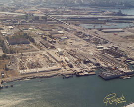
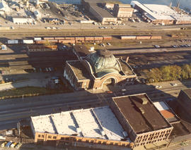
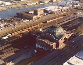
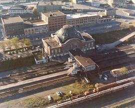
ca. 1975. 1975 Richards color stock footage. Shadows are creeping up on the venerable Union Station, 1717 Pacific Ave., in this 1975 aerial view. By 1975, the magnificent structure was showing its age. A proposed $14,000,000 shopping center/transportation complex sought to restore the station to its former splendor. "Depot Galleria" hoped to add two large buildings to the north and south of the station which would house department stores or perhaps include a major hotel. The Union Station interior would have had a remodeled "Gay '90s" look with the glass dome skylight admitting light to central atrium gardens. Three parking levels would provide parking for 1500 cars. The station would continue to serve as an Amtrak passenger terminal. These ambitious plans by Malls North and BNL Development Corporation (subsidiary of Burlington Northern) would not be realized. (TNT 2-23-75, A-1 article)


Aerial views; Aerial photographs; Union Station (Tacoma); Railroad stations--Tacoma--1970-1980;

D166000-197C

ca. 1975. 1975 Richards color stock footage. Encroaching shadows seek to wrap themselves around the landmark Union Station located at 1717 Pacific Avenue. In 1975 the station still served as an Amtrak passenger terminal. Efforts were made to restore the station to its former glory with the proposed $14,000,000 "Depot Galleria" shopping/transportation complex; however, these plans were stalled. Also visible in this aerial view is the multi-storied Albers Mill, located to the rear of the station at 1821 Dock St. TPL-7982


Aerial views; Aerial photographs; Union Station (Tacoma); Railroad stations--Tacoma--1970-1980; Albers Bros. Milling Co. (Tacoma);

D166000-195C

ca. 1975. 1975 Richards color stock footage. Aerial view of rear of Union Station, 1717 Pacific Ave. as seen in 1975. Fast-forward 30+ years later and the landscape has changed drastically. SR-705 is now where the railroad tracks once ran. The parking lot to the left of the station is now the location of the Washington State History Museum; the Federal Courts are located to the north in a new wing. The five-story building on Pacific Ave. on the extreme left of the photograph is now the University of Washington Bookstore. TPL-2402


Aerial views; Aerial photographs; Union Station (Tacoma); Railroad stations--Tacoma--1970-1980; Railroad tracks--Tacoma--1970-1980;

D166000-120C

ca. 1975. 1975 Richards color stock footage. Closer aerial view of what is believed to be Concrete Technology Corp., 1123 Port of Tacoma Rd., on the Tacoma tideflats. This photograph was possibly taken in the summer of 1975. Concrete Technology dealt in prestressed and precast concrete. Waterway shown is believed to be the Blair Waterway (formerly Port Industrial Waterway).


Aerial views; Aerial photographs; Industrial facilities--Tacoma--1970-1980;

D166000-122C

ca. 1975. 1975 Richards color stock footage. Aerial view of industrial facility on Tacoma's tideflats. This is believed to be Concrete Technology's plant on Port of Tacoma Rd. Waterway is believed to be the Blair (formerly Port Industrial) Waterway.


Aerial views; Aerial photographs; Industrial facilities--Tacoma--1970-1980;

Results 1 to 30 of 824