- Item
- 1920
Part of General Photograph Collection
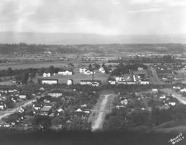
ca. 1920. Aerial view of stadium area of Tacoma in 1920
824 results directly related Exclude narrower terms
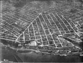
Part of General Photograph Collection
ca. 1920. Aerial view of stadium area of Tacoma in 1920
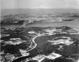
Part of General Photograph Collection
ca. 1939. Artistically modified aerial view of West Tacoma and the Tacoma Narrows. The bridge and the ship under it in the photo were painted in. The bridge was not yet complete in 1939. It would open for traffic on July 1, 1940 and go down in dramatic fashion on November 7, 1940.
Aerial views; Aerial photographs; Neighborhoods--Tacoma--1930-1940; Tacoma Narrows Bridge (Tacoma);
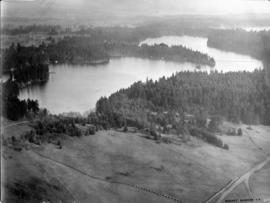
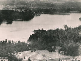
Part of General Photograph Collection
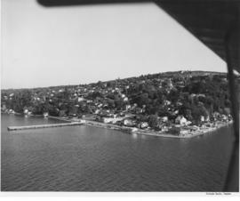
Lake Steilacoom - from the north end looking south. This undated aerial view of Lake Steilacoom was taken by the Barnes Aviation Co. A bridge is visible on the upper right connecting Interlaaken Dr. S.W. to Bridge Road on the west side of the lake. The road on the lower right corner is probably Lake Steilacoom Dr.
Aerial views; Aerial photographs; Lake Steilacoom (Wash.);
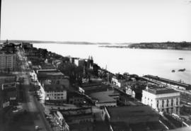
Part of General Photograph Collection
View looking north on Saint Helens St. from the top of the Medical Arts Building on April 5, 1931. Buildings that are clearly visible include the Webster Apartments (629 Saint Helens) and the Elks Temple (565 Broadway- large white building lower right), followed by (right to left) an apartment building (553 Broadway) and the Union Club (539 Broadway.)
Aerial photographs--1930-1940; Cityscapes--1930-1940; Webster Apartments (Tacoma); Elks Temple (Tacoma); Union Club (Tacoma); Commercial streets--Tacoma--1930-1940;
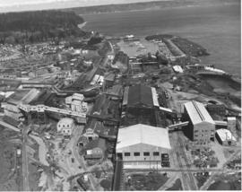
Part of General Photograph Collection
ca. 1948. Aerial view of ASARCO. Lying just beyond the smelter is the Tacoma Yacht Club, followed by the ferry dock. The residential area to the left top is Ruston and the wooded area beyond is Point Defiance Park. TPL-8656
Boathouses; Boats; Tacoma Yacht Club (Tacoma); Mooring; American Smelting & Refining Co. (Tacoma); Smelters--Tacoma--1950-1960; Point Defiance Park (Tacoma);
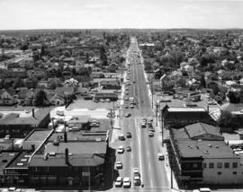
Part of General Photograph Collection
ca. 1970. This is how South 38th St. looking west appeared circa 1970. Yakima Ave. is at the bottom of the photograph. Identified businesses (from left) on Yakima are the Brad Bannon Insurance Co. (3808 Yakima) and the Oroweat Bakers (3802 Yakima). The Arctic Circle Drive-In is nearby at 820 So. 38th St. Also facing 38th St. is the Hartman Furniture store at 803 So. 38th (across the street from Oroweat). On the same side of So. 38th St. as Hartman's but further west is Failor's Pharmacy. The area has had a thriving business district for several decades.
Streets--Tacoma--1970-1980; Neighborhoods--Tacoma--1970-1980; Brad Bannon Insurance Co. (Tacoma); Oroweat Bakers (Tacoma); Arctic Circle Drive-In (Tacoma); Hartman Furniture (Tacoma); Business districts--Tacoma--1970-1980;
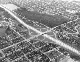
Part of General Photograph Collection
ca. 1968. Interstate 5 was not yet five years old in 1968 when the Tacoma City Photographer shot this aerial view of the South 56th Street cloverleaf. The area has seen major growth in just over thirty years. Tacoma Mall Boulevard, formerly South Ferry Street, runs parallel to the freeway at the right. The undeveloped land at center is the area known as Wapato Hills.
Aerial photographs; Express highways--Tacoma--1960-1970; Interstate 5--Washington (State); Neighborhoods--Tacoma--1960-1970;
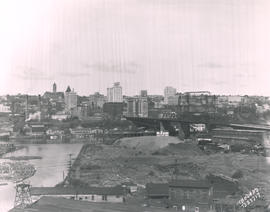
Part of Marvin Boland Photographs
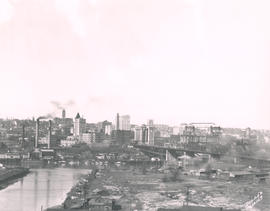
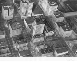
This May, 1931, aerial view of Tacoma's City Center was taken from the industrial Tideflats. The 11th Street Bridge (now Murray Morgan Bridge) is on the right. Jutting into the skyline are (l-r) the Pierce County Courthouse, Puget Sound National Bank, Washington Building, Tacoma Building, and the Art-Deco styled 17-story newly completed Medical Arts Building in the right background. TPL-1788; G91.012
Cityscapes; Aerial views; Aerial photographs; 11th Street Bridge (Tacoma); Pierce County Courthouse (Tacoma); Puget Sound National Bank (Tacoma); Washington Building (Tacoma); Tacoma Building (Tacoma); Medical Arts Building (Tacoma);
Part of Marvin Boland Photographs
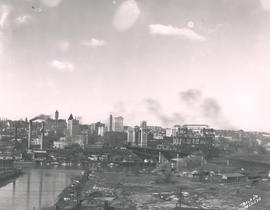
Aerial view looking toward Tacoma's City Center. This May, 1931, view shows many prominent Tacoma landmarks including the Tacoma Building and Perkins Building flanking the 11th Street Bridge (now Murray Morgan Bridge); the newly completed 17-story Medical Arts Building (at center-right); the towering Washington Building at center; Puget Sound National Bank with spire (center-left) and the Pierce County Courthouse with tower in the far left background. TPL-1347; G8.1-021
Cityscapes; Aerial photographs; Aerial views; 11th Street Bridge (Tacoma); Tacoma Building (Tacoma); Medical Arts Building (Tacoma); Washington Building (Tacoma); Puget Sound National Bank (Tacoma); Pierce County Courthouse (Tacoma);
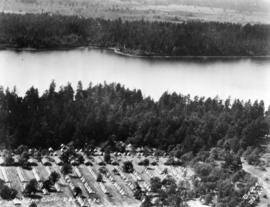
Part of Marvin Boland Photographs
Aerial view of 146th F.A. tents on June 26, 1930. The 146th Field Artillery were participating in the 1930 encampment at Camp Murray. The two-week encampment of the Washington National Guard would last until June 28th. 2600 officers and men, including some 400 Tacomans, would participate in these annual summer maneuvers. Lake in background is American Lake. G77.1-040 (TNT 6-13-30, p. 1-article on encampment)
Aerial photographs; Aerial views; Washington National Guard, 148th F.A. (Tacoma); American Lake (Wash.);
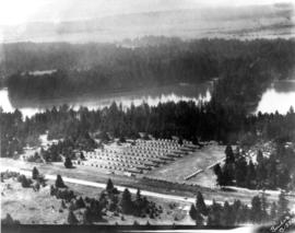
Part of Marvin Boland Photographs
View by air of the 161st Infantry tents at Camp Dent on the grounds of Camp Murray. Camp Dent was the name of the 1930 encampment of the Washington National Guard. Thick stands of trees block the view of American Lake. G69.1-138 TPL-10319
Aerial views; Aerial photographs; Washington National Guard, 161st Infantry (Wash.); American Lake (Wash.);
Part of Marvin Boland Photographs
View by air in July of 1926 of the 146th Field Artillery camp at Camp Lewis. G69.1-137
Aerial views; Aerial photographs; Camp Lewis (Wash.);
Part of Marvin Boland Photographs
Aerial view of Tacoma's east side and Cushman Hospital. The hospital for veterans is the cluster of buildings in the center of this June, 1926, photograph. Surrounding homes are nestled in wooded lots.
Aerial views; Aerial photographs; Cushman Hospital (Tacoma); Hospitals--Tacoma--1920-1930; Neighborhoods--Tacoma--1920-1930;
Part of Marvin Boland Photographs
Aerial view of City Center. Although taken in March of 1925, this view of Tacoma's City Center still shows the contrast between its office buildings and other edifices and the (then) relatively undeveloped industrial Tideflats across the waterway. The Pierce County Courthouse with its 230-foot tower can be seen in the distance; closer near the foreground are the Puget Sound National Bank Bldg. with its familiar spire, the nearly completed Washington Building, the smaller Rust Building, and nearest to the 11th St. Bridge (now Murray Morgan Bridge), the Tacoma Building. TPL-1778; G8.1-027A
Aerial views; Aerial photographs; Cityscapes; Office buildings--Tacoma--1920-1930; Pierce County Courthouse (Tacoma); Puget Sound National Bank (Tacoma);
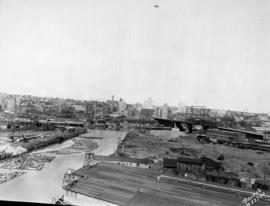
Part of Marvin Boland Photographs
View looking toward the City Center from the Wheeler Osgood plant in March of 1925. Dark smoke blots the spring skies and a few boats float placidly along the City Waterway. There is not much visible traffic on the nearby 11th St. Bridge (now Murray Morgan Bridge.) A similar view is Boland B12169. TPL-1346; G8.1-027B
Aerial views; Aerial photographs; Cityscapes; 11th Street Bridge (Tacoma);
Part of Marvin Boland Photographs
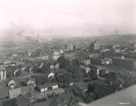
This is how downtown Tacoma and surrounding areas appeared in the fall of 1919. In the foreground are houses and apartments west of Pacific Avenue. A few Tacoma landmarks are clearly visible in the distance: the Puget Sound National Bank building with spire and close to the 11th St. Bridge (now Murray Morgan Bridge), the Tacoma Building and the Perkins Building. Smoke billows from the various industrial plants and lumber mills in the Tideflats across the City (now Thea Foss) Waterway. G8.1-026;
Aerial views; Aerial photographs; Cityscapes; Puget Sound National Bank (Tacoma); Tacoma Building (Tacoma); Perkins Building (Tacoma); 11th Street Bridge (Tacoma);
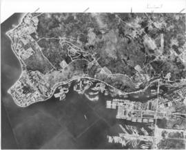
Part of Richards Studio Photographs
Aerial view of the Port of Tacoma, for Cheney Lumber Co. Port Piers, Naval Station (with mothballed fleet) and Hylebos Waterway can be clearly seen. Photo continues around Browns Point and on to Dash Point. Roads appear as clear white lines. TPL-2262
Aerial photographs; Bays--Washington (State); Commencement Bay (Wash.); Port of Tacoma (Tacoma)--1950-1960;
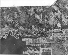
Part of Richards Studio Photographs
Aerial view of the Port of Tacoma, for Cheney Lumber Co. The Port Piers and the Naval Station, with mothballed fleet, can be seen. There were 25 mothballed escort carriers under the care of the Tacoma Group, Pacific Reserve Fleet. The ships were serviced and kept in readiness for war. The Hylebos Waterway can be clearly see all the way to the turning basin. The roads appear as clear white lines. TPL-2261
Aerial photographs; Bays--Washington (State); Commencement Bay (Wash.); Port of Tacoma (Tacoma)--1950-1960;
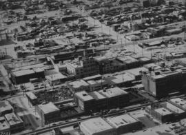
Part of Richards Studio Photographs
ca. 1949. Aerial view, believed to have been taken in December of 1949, of downtown business district featuring Columbia Breweries (center) on South "C" Street where the sprawling plant covered 3-4 acres. Snow is gradually melting over the rooftops on this sunny winter day. The Hunt & Mottet Co. building is at the right foreground.
Aerial views; Aerial photographs; Columbia Breweries, Inc. (Tacoma)--1940-1950; Brewing industry--Tacoma--1940-1950; Hunt & Mottet Co. (Tacoma); Commercial streets--Tacoma--1940-1950;
Part of Richards Studio Photographs
Aerial of Dash Point. Sky Harbor Airport. A pier juts out into the water. Several large residential homes can be seen at the water's edge. TPL-5564
Aerial photographs; Piers & wharves--Dash Point; Neighborhoods--Tacoma--1950-1960;
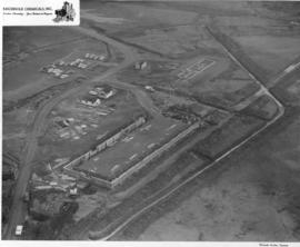
Part of Richards Studio Photographs
An aerial photograph of the sprawling Pennsylvania Salt Manufacturing Co. of Washington was taken in October, 1954. The Tacoma plant, whose parent company was founded over one hundred years ago in Natrona, Pennsylvania, has been at its 40 acre Tideflats location on the Hylebos waterway since 1929. Throughout the years, it has undergone rapid expansion of its facilities and also its product lines. Despite its name, it has no connection with the manufacture of table salt. Photograph ordered by Pennsylvania Salt Manufacturing Co. of Washington.
Aerial photographs; Pennsylvania Salt Manufacturing Co. of Washington (Tacoma); Chemical industry--Tacoma--1950-1960; Hylebos Waterway (Tacoma);
Part of Richards Studio Photographs
Copy of customer's print. The Port of Tacoma Industrial area is seen in an aerial view in a photograph copied for Howard R. Smith. Mr. Smith, a well-known Tacoma businessman, had been president of the Tacoma Athletic Commission and involved in advertising for many years. The photograph was copied on August 27, 1954; actual date of print is unknown. Log dumps for various lumber concerns are clearly visible to the picture's right.
Aerial photographs; Port of Tacoma (Tacoma);
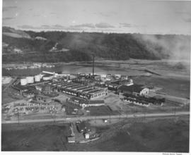
Part of Richards Studio Photographs
Aerial photographs requested by Reichhold Chemicals, Inc., were taken on January 12, 1956. The company had purchased 51.2 acres of land from the Port of Tacoma for $204,920. They would be constructing a large plant on acreage south of Lincoln Avenue between the Tacoma Sash & Door and Pennsalt. Reichhold hoped to begin operations in April, 1956. The protein adhesive and pentachorohenol plant would first employ 50 people. Aerial view of land shows sides of the building going up; there is no roof or flooring. Makeshift dirt roads have been created so that construction workers' vehicles and heavy equipment can reach the plant site. (TNT 12-25-55, B-4)
Aerial photographs; Building construction; Reichhold Chemicals, Inc. (Tacoma);
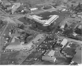
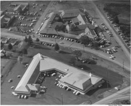
Part of Richards Studio Photographs
This aerial view of the Lakewood Center was taken in November of 1955 on behalf of the Lakewood Development Co., who operated the community center. Norton Clapp had originally built the Lakewood Community Center in 1937 as one of the nation's first one-stop shopping centers. Clapp, known as the founder of Lakewood, nurtured the idea of a growing suburban community and realized that it would need additional businesses and services to help it grow. The Lakewood Center underwent several expansions in the 1950's. In November, 1955, it reopened to celebrate a new addition, the modernized Colonial in an open triangle shape on the east side of the center. One 285-ft. leg faced Gravelly Lake Dr., the other 235-ft leg faced Mt. Tacoma Dr. with the "open" side to Bridgeport Way. Fourteen new businesses, including Sprouse-Reitz variety store, Lakes Realty, Andrews Women's Apparel, Lou Johnson, Selden's, Tacoma Savings and Loan, and Lakewood Record and Book Shop, took occupancy in the new building. (TNT 11-16-55, C-14)
Aerial photographs; Lakewood Community Center (Lakewood); Shopping centers--Lakewood--1950-1960; Lakewood Development Co. (Lakewood);
Part of Richards Studio Photographs
Aerial photographs were taken of the Lakewood Center on November 4, 1955. Originally built in 1937 by Norton Clapp, the Lakewood Community Center was among the first of the country's one-stop shopping centers. It had undergone tremendous expansion in the early 1950's to keep up with the rapidly growing suburban area surrounding Lakewood. The Center was to celebrate its grand reopening later in November, 1955, with the addition of the large building nearest the bottom. It would be designed by the architectural firm of Lea, Pearson & Richards in the shape of an open triangle. The longer side, 285 feet, would face Gravelly Lake Drive with the shorter 235 foot side facing Mt. Tacoma Dr. The service or open side faces Bridgeport. Parking was available all around the building. Fourteen shops had already reserved space in the new addition. Photograph ordered by Lakewood Development Co. (TNT 11-16-55, C-14)
Aerial photographs; Lakewood Community Center (Lakewood); Shopping centers--Lakewood--1950-1960; Lakewood Development Co. (Lakewood);
Part of Richards Studio Photographs
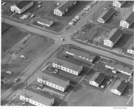
Aerial photographs of possibly military base were taken in November, 1955, on behalf of the law firm of Anderson, Pearson & Anderson. This may be on the grounds of Fort Lewis. There appears to be a church with steeple in the far left corner of the photograph. Other buildings appear to be temporary barracks.
Aerial photographs; Anderson, Pearson & Anderson (Tacoma);
Part of Richards Studio Photographs
Aerial photograph of downtown Tacoma to show the spired Puget Sound National Bank building at 11th and Pacific (1119 Pacific Ave.) To the building's left is Peoples Department Store at 1101-07 Pacific and to its right is the National Bank of Washington, 1123 Pacific, the 2002 location of the Tacoma Art Museum. Behind facing A Street is the Federal Building and the Post Office at 1102 A Street. The city appears divided into a grid of large office buildings. The streets, left to right, vertically are Commerce, Pacific and A Street. They are divided by, top to bottom, by 11th Street and 12th Street. Left to right at the top of the picture are the Rust building at 950 Pacific, the Washington Building at 1019 Pacific and the Tacoma Building at 1017-21 A Street. Across 11th Street from the Tacoma Building is the Perkins building at 1101 A Street.
Puget Sound National Bank (Tacoma); Aerial photographs;
Part of Richards Studio Photographs
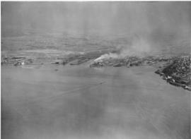
Aerial of the Port of Tacoma, taken from over Commencement Bay heading into the Port. Tacoma can be seen as the forested area on the right dotted with buildings, with the Tideflats laying to the left of the bridge shrouded densely with industrial smoke.
Aerial views; Port of Tacoma (Tacoma)--1950-1960;
Part of Richards Studio Photographs
Aerial of the Port of Tacoma, taken from over Commencement Bay heading into the Port. Tacoma can be seen as the forested area on the right dotted with buildings, with the Tideflats laying to the left of the bridge shrouded densely with industrial smoke.
Aerial views; Port of Tacoma (Tacoma)--1950-1960;
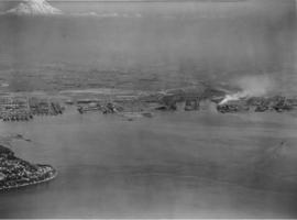
Part of Richards Studio Photographs
Aerial of the Port of Tacoma, taken from over Commencement Bay heading into the Port. Mount Rainier looms whitely in the background. Browns Point can be seen in the left foreground, with the fingers of the port and the inlets of waterway further back.
Aerial views; Port of Tacoma (Tacoma)--1950-1960;