Aerial Photography

Taxonomy

Code

Scope note(s)

Source note(s)

Display note(s)

Hierarchical terms

Aerial Photography

Equivalent terms

Aerial Photography

Associated terms

Aerial Photography

824 Collections results for Aerial Photography

824 results directly related Exclude narrower terms

A102546-3

Aerial of the Port of Tacoma, taken from over Commencement Bay heading into the Port. Mount Rainier looms whitely in the background. Browns Point can be seen in the left foreground, with the fingers of the port and the inlets of waterway further back.


Aerial views; Port of Tacoma (Tacoma)--1950-1960;

D101899-2

A rare early snowfall blankets the earth in this aerial shot of the Hylebos Waterway in October of 1956. Log booms float in the water and part of the mothballed fleet of escort carriers, kept in readiness under the care of the Tacoma Group, Pacific Reserve Fleet, can be seen. Mt. Rainier is partially obscured by haze and smoke rising from the industrial sites on the Tideflats.


Aerial photographs; Hylebos Waterway (Tacoma); Snow--Tacoma--1950-1960;

A100333-1

Aerial view of Reichhold Chemical Co. on the Tideflats. Reichhold manufactured chemicals used by the plywood industry. Occupying 51 acres of land, the company was a large concern that would employ over 100 people.


Aerial photographs; Building construction; Reichhold Chemicals, Inc. (Tacoma);

A98409-1A

ca. 1956. Mountain View Memorial Park in Lakewood. An aerial view of the cemetary. This is the left hand side of a large print of a single negative. For the right hand side see A98409 image 1b. Curved roads wind through the grounds providing access to the many grave sites. The war memorial can be seen right, just below center. Other structures located in the park include the funeral home, crematory, mausoleum, chapel and columbarium.


Cemeteries--Lakewood; Mountain View Memorial Park (Lakewood); Aerial views; Aerial photographs;

A107984-10

Aerial photographs of the Huntington Rubber Mills were taken on July 13, 1957. This is possibly the Seattle plant at 35 W. Lander. The business occupied a large chunk of land bordered by several roads. There were at least four separate buildings making up the plant. Photograph ordered by Huntington Rubber Mills.


Aerial photographs; Huntington Rubber Mills (Seattle); Industrial facilities--Seattle;

D105615-1

This aerial view of Tacoma's West End and the Tacoma Narrows Bridge was taken in March of 1957. 6th Avenue cuts upward through the center of the picture curving to the right as it feeds onto the Narrows Bridge. The road starting at the bottom right and running into 6th Ave. is Pearl Street, with the Tacoma Auto View Theater, 1202 North Pearl near the right edge. The buildings at the corner of 6th and Pearl are the early Highland Hills Shopping Center, 5915 6th Ave.. The bare land just above and to the right of the Auto View became the Highland Hills Golf Course.


Aerial photographs; Tacoma Narrows Bridge (Tacoma); Neighborhoods--Tacoma--1950-1960;

A104350-6

Construction at Fort Lewis remained strong in the mid-1950's as the military population continued to grow. February 12, 1957, aerial photographs show two company barracks and utilities structures being built at the south end of Gray Field. Donald M. Drake Co. of Portland, Oregon, apparently were involved in Contract #3706. Photograph ordered by the Donald M. Drake Co.


Aerial photographs; Building construction--Fort Lewis; Donald M. Drake Co. (Portland, Or.);

A104350-2

Aerial photographs of the south end of Gray Field on Fort Lewis were taken on February 12, 1957. Construction appears to be continuing on two company barracks and utilities building. Roads will have to be extended to meet the new quarters. Photograph ordered by Donald M. Drake Co., Portland, Oregon. TPL-10352


Aerial photographs; Building construction--Fort Lewis; Donald M. Drake Co. (Portland, Or.);

A103462-1

Aerial photographs were taken on December 4, 1956, at the request of U.S. Oil & Refining Co. of the petroleum tank "farm" on the Tideflats heading toward town. The huge light-colored cylinders dot the landscape. U.S. Oil had broken ground in July, 1955, for a new 10-million dollar oil refinery on an 120 acre site in the Tideflats. TPL-5897


Aerial photographs; Storage tanks--Tacoma; US Oil & Refining Co. (Tacoma);

C112481-1

Copy of customer print. Aerial photographs of Seattle's Huntington Rubber Mills' facilities were taken in the spring of 1958. The smaller building in front may have been the office and the larger elongated buildings nestled close together, plant facilities. All three have semi-curved roofs. There were also two other buildings joined together to the left of the photograph. Photograph ordered by Huntington Rubber Mills.


Aerial photographs; Huntington Rubber Mills (Seattle);

A112205-11

Aerial photographs of South Fort Lewis were taken on January 26, 1958. The carefully laid out design appears symmetrical, with identical buildings and parking lots on both sides of the wide field. These may have been newly constructed buildings. The view taken from the air gives the appearance of a architectural model setup. Forested lands are abundant on the property; there is plenty of space for expansion. Photograph ordered by Donald L. Drake Co.


Aerial photographs; Building construction--Fort Lewis;

A111233-3

This aerial photograph of the St. Regis pulp mill looking toward Mt. Rainier was taken on behalf of Malcolm McGhie in December, 1957. The St. Regis plant was flanked by the Puyallup Waterway (L) and St. Paul Waterway (R) with the Middle Waterway to the extreme right. Smoke pours from the St. Regis plant facilities on a typical winter day; the plant employed multiple shifts so that operations could be conducted 24 hours a day, seven days a week. The multi-wall bag plant and kraft-pulp division are in the center of the photograph. The long narrow building is for kraft-pulp, adjoining the white-walled rectangular bag plant. The St. Paul & Tacoma Lumber Co. sawmill is in close proximity to the kraft pulp and paper mill. In August, 1957, St. Paul became an operating subsidiary of the St. Regis Paper Co. St. Paul had the largest retail lumber yard in the state of Washington. Its sawmill had furnished chips to St. Regis for a number of years, providing about 35% of the pulp mill's wood requirements. (TPL-5890, St. Regis Annual Report - 1957, p. 14-15)


Aerial photographs; St. Regis Paper Co. (Tacoma)--1950-1960; St. Paul & Tacoma Lumber Co. (Tacoma);

A111233-1

Aerial photographs of the Middle Waterway and the Tideflats area were taken on behalf of Malcolm McGhie in December, 1957. The St. Paul & Tacoma Lumber Co. facilities, sawmill, and log ponds are toward the center of the photograph. The St. Regis plants are, with smokestacks billowing, are near the top of the picture. Forty-five years later, the Tideflats landscape would be quite transformed. The City Waterway (now Thea Foss Waterway), although not in this picture, would no longer have docks, plywood mills, shipyards and warehouses crowding its sides. A 29.3 million dollar Museum of Glass and the adjoining Chihuly Bridge of Glass would be the first of millions of dollars of improvement to the area. TPL-5893


Aerial photographs; Middle Waterway (Tacoma); St. Paul & Tacoma Lumber Co. (Tacoma); St. Regis Paper Co. (Tacoma)--1950-1960;

D111635-2

Additional aerial photographs of the Tideflats area were requested by Malcolm McGhie and taken on January 3, 1958. Earlier photographs were taken about a month prior. Dash Point can be spotted protruding into the bay on the right with Vashon Island at the top of the photograph. St. Paul & Tacoma Lumber Co., who in August, 1957, became a subsidiary of St. Regis Paper Co., can be clearly seen towards the middle of the photograph including its loaf-shaped buildings. Its sawmill had provided 35% of the pulp mill's wood requirements. St. Regis is adjacent to its new subsidiary and to the upper right. The City Waterway is the body of water to the extreme left; new developments, with the removal of warehouses, shipbuilding, and mills nearly 45 years later have changed its landscape and revitalized the area.


Aerial photographs; St. Paul & Tacoma Lumber Co. (Tacoma); St. Regis Paper Co. (Tacoma)--1950-1960;

D111635-1

This was how Tacoma's Tideflats appeared from the air on January 3, 1958. The area was crowded with pulp and paper mills, lumber yards, log ponds and warehouses. Tacoma's easy access to rail and water made the transport of industrial and wood products a simpler process. View of, left to right, the City, Middle, St. Paul and Puyallup Waterways. The St. Regis plant was located on the finger between the Puyallup and St. Paul waterways in the buildings with the "L" shape. The St. Paul & Tacoma Lumber sawmill and buildings were close by, at the rear of the waterway in the loaf shaped buildings. In August 1957, St. Paul became an operating subsidiary of the St. Regis Paper Co. Photograph ordered by Malcolm McGhie.


Aerial photographs; St. Regis Paper Co. (Tacoma)--1950-1960; St. Paul & Tacoma Lumber Co. (Tacoma);

D109420-7

Aerial photographs- U.S. Oil Refinery. Aerial photographs of the U.S. Oil refinery were taken on October 3, 1957. The petroleum "tank farm" was located on an 120 acre site in the Tideflats. The light colored round cylinders shown in the photograph are probably the storage tanks. The refinery would be close to both rail and water transport. Photograph ordered by U.S. Oil & Refining Co.


Aerial photographs; Storage tanks--Tacoma; US Oil & Refining Co. (Tacoma);

A108235-1

An aerial photograph of the Hooker Electrochemical plant in the Tideflats was taken on July 24, 1957, for possible order by the company. Storage tanks appear to be loaded on railroad cars on two parallel tracks. Hooker was the second chlor-alkali plant in the United States and the first caustic soda plant in the Pacific Northwest. This was apparently an aerial view of an area of Hooker Electrochemical Co. on Industrial Waterway.


Aerial photographs; Hooker Electrochemical Co. (Tacoma); Chemical industry--Tacoma--1950-1960;

D108639-2

Lakewood Center as pictured by air in August of 1957. Located near the busy streets of Bridgeport Way and Gravelly Lake Dr., the Lakewood Center was among the first of the nation's one-stop shopping centers. It underwent several expansions including a major addition in 1955 when the modified Colonial, shown above with an "open" triangular side, opened with fourteen new businesses. The shopping center was 15 minutes from downtown Tacoma, five minutes from McChord and ten from Fort Lewis. It provided an alternative shopping area for residents in the communities outside Tacoma city limits with the added attraction of more parking than in downtown Tacoma.


Aerial photographs; Lakewood Community Center (Lakewood); Shopping centers--Lakewood--1950-1960;

D108639-5

Aerial view of the Villa Plaza Shopping Center taken for its opening in August of 1957. One thing was clear: there was plenty of parking available for shoppers at Lakewood's newest shopping center, the Villa Plaza, and plenty of room for expansion if necessary. The Villa Plaza heavily advertised its free 4000-car parking lot and the convenience of many stores side-by-side including familiar names J.C. Penney's, Woolworth's and Rhodes Brothers. Acknowledging the buying power of suburbanites, these major department stores left their flagship operations downtown but garnered new shopping dollars by opening branches outside city limits. The Villa Plaza, like the older Lakewood Center, was closer to McChord and Fort Lewis than downtown.


Aerial views; Aerial photographs; Villa Plaza Shopping Center (Lakewood); Shopping centers--Lakewood--1950-1960; Parking lots--Lakewood;

A117142-3

Although Annie Wright Seminary had been at this location, 827 Tacoma Ave. No., only since 1924; it was in the process of celebrating its Diamond Jubilee in October of 1958 when this picture was taken. The first class of 93 girls entered Annie Wright in the fall of 1884 in the school's first building at Tacoma & Division Avenues. Annie Wright experienced financial troubles due to decreased enrollment in the 1930's and increased expenses during the early part of WWII; the school was nearly forced to close in 1943. Headmistress Ruth Jenkins and the Board of Trustees were given 48 hours to raise enough money to pay the most outstanding debts. Friends, alumnae and students rallied to save the school. Annie Wright Seminary continued to expand with a new wing added in 1957. In 2002, the school had pupils from seven states and eight countries and was planning to add a 10.3 million three story addition. (The Shield:1959, TNT 9-30-02, B-1)


Aerial photographs; Annie Wright Seminary (Tacoma)--1950-1960; Private schools--Tacoma;

A117638-1

Aerial photographs taken on behalf of George Franklin on November 3, 1958, of the South 84th and Pacific Avenue neighborhoods show a growing southend presence in the city. While there appears to be room for development, Pacific Avenue around this area is starting to develop with many businesses. Safeway, Vaughan's Pacific Avenue Lumber and Puget Sound National Bank all are close by.


Aerial photographs; Neighborhoods--Tacoma--1950-1960;

A117638-4

Aerial photographs taken on November 3, 1958, show Tacoma city streets neatly gridded and stretching into the horizon. This area was the South 84th & Pacific Avenue neighborhood. A few large businesses had started to relocate to this southend location including Puget Sound National Bank, Safeway, and Vaughan's Pacific Avenue Lumber Co. Pacific Avenue was a major thoroughfare and businesses located on or near it attracted much drive-by traffic. Photograph ordered by George Franklin.


Aerial photographs; Neighborhoods--Tacoma--1950-1960;

C116284-1

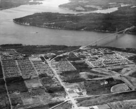
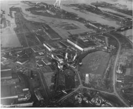
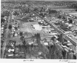
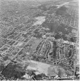
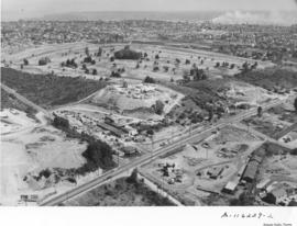
ca. 1958. Copy of customer's print. An artist has placed his conceptualized drawing of the new regional shopping center, to be later called the Tacoma Mall, along with the future I-5 freeway over an aerial photograph of the South 38th St. area. Steele Street would lead into the shopping center from South 38th St. The Lincoln Heights housing development are the winding roads just off 38th St. The heavily wooded area near the Mall is presumably the Tacoma Cemetery and South Park. Allied Owners, Inc., had applied four times by August, 1958, for rezoning from a residential to regional shopping center district. They wanted to build a $20 million South Tacoma shopping headquarters, "Town Center," in an area surrounding South 43rd, South 48th & Pine Sts. and the freeway. Each time their request before the City Planning Commission had been denied. Photograph ordered by Allied Owners, Inc. (TNT 8-31-58, A-6)


Aerial photographs; Architectural drawings;

A116227-2

Educators Manufacturing Co., makers of school furniture, opened a new plant in the Tideflats area in 1958. Located at 3401 Lincoln Avenue, close to Taylor Way, the company shared the same address with Buffelen Woodworking & Buffelen Sales Co. The million dollar plant was located on a sprawling ten acre industrial site in the Tideflats. 133,000 square feet of plant space handled mass production of quality controlled classroom equipment. All production processes were located on one floor which reduced material handling cost. Hart Construction Co. were the general contractors. View of large plant, apparently divided into three sections, all with gently curved roofs. There is a large parking lot bordered by stacks of plywood. Washington Cooperative Farmers Feed Mill looms in the background. Photograph ordered by Educators Manufacturing Co. (TNT suppl. 11-9-58, p. 4) TPL-9831


Aerial photographs; Educators Manufacturing Co. (Tacoma); Furniture industry--Tacoma--1950-1960; Industrial facilities--Tacoma--1950-1960;

A116017-4

This aerial photograph, taken for Allied Owners, Inc. in August of 1958, shows the area of South Tacoma that would become home to the Tacoma Mall Shopping Center. The winding, twisting roads toward the lower center are the Lincoln Heights neighborhood. The road on the far right is South Pine. South 38th Street cuts through the middle of the photo from left to right. The tree covered area at right center is now the site of the Tacoma Mall. I-5 is yet to be built. At the top is Wapato Park and Wapato Lake.


Aerial photographs; Neighborhoods--Tacoma;

A116017-5

The South Tacoma area would be experiencing many changes in the late 1950's with the coming of the Tacoma Mall and the freeways. Aerial photographs taken for Allied Owners, Inc., on August 8, 1958, show the carefully laid out streets of the South Tacoma. It shows South 56th Street running from left to right across the center of the picture to the wooded area at the right, Wapato Hills. The church with the tall steeple in the left corner is the Church of Visitation on South 58th St. The area where the Tacoma Mall would eventually be built may have been in or close to the woods in the upper center of the photograph, next to the flat L shaped area.


Aerial photographs; Neighborhoods--Tacoma;

A116582-2

A new building was under construction at the large Pederson Fryer Farms complex at 2901 East 72nd when this aerial photograph was taken on September 7, 1958. The automatic poultry processing equipment at Pederson's had the capacity to dress and package 2,500 chickens per hour. At that time, Pederson's employed 88 people. The family personally supervised the raising of special hybrids and controlled their feeding and housing. By the 1990s they were Washington State's largest producer of poultry with 450 employees. After 48 years in the poultry business, Pederson Farms declared bankruptcy in 1996; they were bought out by Foster Farms of Modesto, California in 1997. Photograph ordered by Pederson Fryer Farms.


Aerial photographs; Pederson Fryer Farms (Tacoma);

A116893-2

The Richards Studio went aloft on a cloudy September 22, 1958, to take views of the Tacoma landscape. Smoke billows from the industrial Tideflats area. View of city's downtown area includes 11th St. Bridge, City (now Thea Foss) Waterway, heavily wooded Wright Park, and new County-City Building. Streets are neatly aligned with trees on most residential lots. The Tacoma Lawn Tennis Club can be spotted near the right lower corner with its unusual curved streets.


Aerial photographs; Tacoma Lawn Tennis Club (Tacoma);

A116229-2

Aerial photographs taken on August 14, 1958, of the Center & Pine area paint an almost surrealistic view of the surroundings. The Lundberg Concrete Pipe Co. is the cluster of buildings located near the center of the picture. As their name indicates, they were pipe manufacturers. Located on top of a neighboring hillside is the storage area for the pipes. Beyond Lundberg Concrete appears to be the Allenmore Golf Course. Photograph ordered by Lundberg Concrete Pipe Co., Inc.


Aerial photographs; Lundberg Concrete Pipe Co., Inc. (Tacoma); Pipes (Conduits)--Tacoma; Industrial facilities--Tacoma;

Results 241 to 270 of 824