Aerial Photography

Taxonomy

Code

Scope note(s)

Source note(s)

Display note(s)

Hierarchical terms

Aerial Photography

Equivalent terms

Aerial Photography

Associated terms

Aerial Photography

824 Collections results for Aerial Photography

824 results directly related Exclude narrower terms

TPL-835

ca. 1938. Dickman Lumber, 2423 Ruston Way. This aerial view, taken circa 1938, shows vast stacks of lumber ready to be loaded onto ships. Dickman Lumber was located just south of the present Old Town dock. It was purchased in 1922 by Leonard Howarth and Ralph L. Dickman, Sr. Dickman Lumber was closed in September of 1977 and its mill destroyed by fire in January of 1979.


Aerial photographs; Dickman Lumber Co. (Tacoma); Lumber industry--Tacoma--1930-1940; Shipping--Tacoma--1930-1940;

D7232-3

ca. 1938. Aerial view of North End Tacoma showing Annie Wright Seminary, surrounding neighborhood and Commencement Bay. The Tudor Gothic building was built in 1924 on a design by Sutton, Whitney & Dugan.


Aerial photographs; Private schools--Tacoma; Annie Wright Seminary (Tacoma)--Buildings;

D7232-5

Aerial view of North End Tacoma showing Annie Wright Seminary, surrounding neighborhood and Commencement Bay.


Aerial photographs; Private schools--Tacoma; Annie Wright Seminary (Tacoma)--Buildings;

D7232-6

Aerial view of North End Tacoma showing Annie Wright Seminary, surrounding neighborhood and Commencement Bay.


Aerial photographs; Private schools--Tacoma; Annie Wright Seminary (Tacoma)--Buildings;

D8245-11

Associated Oil Company aerial view of Tacoma from The Narrows looking east. Ordered by George Martinac, North Pacific Bank Note Company.


Aerial photographs;

D8245-5

ca. 1939. Associated Oil Company aerial view of Tacoma, West End to Downtown, tideflats and beyond. Piers for first Narrows Bridge under construction. Ordered by George Martinac, North Pacific Bank Note.


Aerial photographs; Tacoma Narrows Bridge (Tacoma); Bridges--Tacoma;

D8245-30

ca. 1939. Associated Oil Company aerial view of Tacoma West End showing area above Titlow Beach and Day Island. Photograph taken circa 1939. Ordered by George Martinac, North Pacific Bank Note Company.


Aerial photographs; Titlow Park (Tacoma);

D8245-12

ca. 1939. Associated Oil Company aerial view of west side cement plant for first Narrows Bridge construction. Ordered by George Martinac, North Pacific Bank Note.


Aerial photographs; Tacoma Narrows Bridge (Tacoma); Bridges--Tacoma;

D8245-3

Associated Oil Company aerial view of Northeast Tacoma, Vashon Island, and Commencement Bay. Ordered by George Martinac, North Pacific Bank Note Company.


Aerial photographs;

D8245-4

Associated Oil Company aerial view looking south toward Lakewood. Cemetery and highway in foreground. Ordered by George Martinac, North Pacific Bank Note Company.


Aerial photographs;

TPL-010

ca. 1939. Artistically modified aerial view of West Tacoma and the Tacoma Narrows. The bridge and the ship under it in the photo were painted in. The bridge was not yet complete in 1939. It would open for traffic on July 1, 1940 and go down in dramatic fashion on November 7, 1940.


Aerial views; Aerial photographs; Neighborhoods--Tacoma--1930-1940; Tacoma Narrows Bridge (Tacoma);

D8245-1

ca. 1939. Aerial view from the Narrows of Tacoma's West End with downtown and the Tideflats beyond. Running down the center of the photograph is Sixth Ave. as it veers off to Titlow Beach in the lower right hand. It is crossed by Pearl Street, where the excavation for (what is believed to be) a planned Tacoma airport forms a pattern on the ground. The area is largely undeveloped. Construction on the Narrows Bridge (Galloping Gertie) had begun but was far from completion. For a 1961 aerial view of the same location, see D129800, images 43 & 131. TPL-9156


Aerial photographs;

D8245-13

Associated Oil Company aerial view of west side cement plant and construction of west pier for first Narrows Bridge. Ordered by George Martinac, North Pacific Bank Note.


Aerial photographs; Tacoma Narrows Bridge (Tacoma); Bridges--Tacoma;

D8245-22

ca. 1939. Associated Oil Company aerial view of west side cement plant and construction of west pier for first Narrows Bridge. Ordered by George Martinac, North Pacific Bank Note. TPL-6712


Aerial photographs; Tacoma Narrows Bridge (Tacoma); Bridges--Tacoma;

D8245-7

ca. 1939. Associated Oil Company aerial view of Tacoma West End from Day Island to Point Defiance and beyond. Piers for first Narrows Bridge under construction. Ordered by George Martinac, North Pacific Bank Note.


Aerial photographs; Tacoma Narrows Bridge (Tacoma); Bridges--Tacoma;

D9334-5

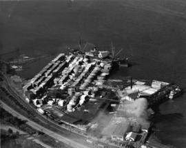
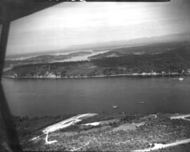
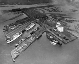
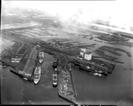
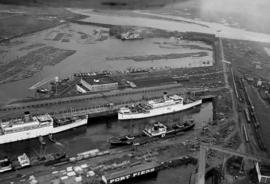
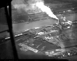
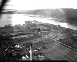
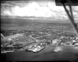
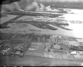
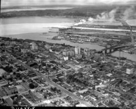
This aerial view, taken January 13, 1940, shows the Port of Tacoma piers with two docked, white transport ships. Three transport ships, the Hunter Liggett, Leonard Wood and St. Mihiel, were in Commencement Bay to transport over 7,500 soldiers from Fort Lewis to the biggest war games in US history. This is the biggest passenger embarkation in the history of the Tacoma port. The troops will invade the California coast from the sea. They will strike at an undisclosed location somewhere on the 400 mile coast between San Francisco and Santa Barbara. This will be the major offensive of the war games to be held January 15-22nd. Also in the photograph are the Co-op's white grain elevators; the waterway is crowded with log booms. The two other cargo vessels pictured are believed to be the South American freighter Coya and the Japanese freighter Koei Maru. ( T. Times 1-3-40, p. 1-article; 1-11-40, p.1-article; 1-13-40, p.1-article)


Aerial photographs; Bays--Washington (State); Commencement Bay (Wash.); Port of Tacoma (Tacoma)--1940-1950; Logs; Ships; Piers & wharves--Tacoma--1940-1950;

D9334-6

Aerial view of Port Piers on January 13, 1940, showing transport ships. Log booms in background. The three larger vessels are the military transport ships, the Hunter Liggett, Leonard Wood and St. Mihiel. They will be boarding 7500 soldiers from Fort Lewis and taking them to join the 3rd Division Black Army at sea. During the upcoming war games, the Black Army will invade the coast of California from the sea. The games are the largest in US history and involve both the Army and Navy. In 1940, the military was looking ahead to possible involvement in the European conflict which would become World War II. (T. Times 1/11/1940, pg. 1)


Aerial photographs; Bays--Washington (State); Commencement Bay (Wash.); Port of Tacoma (Tacoma)--1940-1950; Logs; Ships;

D9334-7

In this aerial photograph from January 1940, two white Navy transport ships sit at dock in Slip No. One of the Port Industrial Waterway waiting to take on soldiers from Fort Lewis. On Friday January 13th, 7,500 soldiers boarded three transport ships to be carried to California to take part in the largest Army-Navy "war games" exercise ever held on U.S. soil, to that date. When the ships pulled out Saturday morning, Fort Lewis was virtually deserted; only a maintenance staff of a few hundred men stayed behind. (T. Times 1/11/1940, pg. 1)


Aerial photographs; Bays--Washington (State); Commencement Bay (Wash.); Port of Tacoma (Tacoma)--1940-1950; Logs; Ships;

D9927-2

This aerial view of McChord Field from June of 1940 shows the U.S. Army's Northwest airbase shortly before it was dedicated on July 3rd. The massive building in the center is the new enlisted men's barracks which could house 1,200 men. In the upper right corner are two of the six-story tall hangers that housed the base's fleet of 24 Douglas B-18A "medium" bombers. The Army had already spent $7 million building the airbase, and millions more would be needed before it was completed. (T.Times 7/1/1940 p.1)


Aerial photographs; McChord Field (Tacoma);

BOWEN TPL-7012

ca. 1941. Circa 1941 aerial view of the business district of Tacoma at night clearly showing the buildings on Pacific Ave. between 9th and 11th on the east side of the street. Buildings shown include: the Anderson building (1001-05 Pacific), the Bank of California (1011-1013 Pacific), and the Washington Building (1019 Pacific). There is a large neon sign for Mobil Gas on top of the Washington Building.

D11701-2

Aerial view of Ferro-Alloys plant on Tideflats. [Also dated 08-01-1941]


Aerial Photographs - Pierce County - Tacoma - Port IndustrialIndustries - Metal Industries

D11649-2

Aerial view of downtown Tacoma including waterfront warehouses and half-moon railroad yards. This July of 1941 photograph, looking westward, shows the densely packed business districts of Tacoma as well as outlying residential areas. The waterway is the City (now Thea Foss) Waterway with the 11th St. Bridge (now Murray Morgan Bridge) in view.


Aerial views; Aerial photographs; Cityscapes; City Waterway (Tacoma); Business districts--Tacoma--1940-1950; Commercial streets--Tacoma--1940-1950;

D11649-6

1941 Aerial view of downtown Tacoma showing the Central Business District, Port/Industrial, and Central residential areas. The 11th St. Bridge (now Murray Morgan Bridge) leads traffic over the City (now Thea Foss) Waterway over to the industrial Tideflats.


Aerial views; Aerial photographs; Cityscapes; City Waterway (Tacoma); Business districts--Tacoma--1940-1950; Commercial streets--Tacoma--1940-1950; 11th Street Bridge (Tacoma);

D11649-22

Aerial view of Sea-Tac Shipyard taken on July 20, 1941. Even before the U.S. entered WWII, the Seattle-Tacoma Shipyard was busy with building tankers and C-3 freighters for the government.


Aerial views; Aerial photographs; Seattle-Tacoma Shipbuilding Corp. (Tacoma); Boat & ship industry--Tacoma--1940-1950;

D11649-15

Aerial view of industrial section of Tacoma as seen on July 20, 1941. Log booms in foreground.


Aerial views; Aerial photographs; Logs;

D11649-19

1941 Aerial view of Sea-Tac Shipyard with Peterman Manufacturing Company in foreground, looking west. The Peterman Co. manufactured fir doors and veneer panels. It was forced to vacate the property in June of the following year as the Shipyard needed space to build the many ships under contract.


Aerial views; Aerial photographs; Seattle-Tacoma Shipbuilding Corp. (Tacoma); Boat & ship industry--Tacoma--1940-1950; Peterman Manufacturing Co. (Tacoma);

D11649-16

Aerial view in July of 1941 of industrial section of Tacoma from Commencement Bay looking eastward with focus on various waterways.


Aerial views; Aerial photographs; Waterways;

D11649-10

This aerial view of the Pierce County Hospital and its surrounding neighborhood was taken in July of 1941. The hospital's new north wing and new west wing were nearing completion. An extra three-mil tax levy was passed in March of 1940 to fund the expansion of the hospital. At the upper left corner is the excavation for the Lincoln Bowl, which was not completed until after WWII. Pierce County took over ownership of the hospital in 2000. (T.Times 7/31/1941 p.5)


Aerial photographs; Pierce County Hospital (Tacoma); Neighborhoods--Tacoma--1940-1950;

D11649-13

Aerial view of industrial section of Tacoma taken on July 20, 1941. The business district of downtown Tacoma is in the distance. Various log dumps dot the waterways in the foreground.


Aerial views; Aerial photographs; Cityscapes; Logs; Waterways;

D11649-8

Aerial view of downtown Tacoma showing Central Business District and Port/Industrial areas. This view, looking east toward the bustling industrial Tideflats, was taken on July 20, 1941.


Aerial views; Aerial photographs; Cityscapes; Business districts--Tacoma--1940-1950; Commercial streets--Tacoma--1940-1950;

Results 31 to 60 of 824