- Item
- 1938
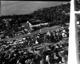
Part of Richards Studio Photographs
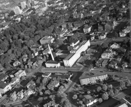
ca. 1938. Aerial view of Tacoma General Hospital and surrounding neighborhood including Wright Park as pictured circa 1938.
Aerial photographs; Tacoma General Hospital (Tacoma); Wright Park (Tacoma);
824 results directly related Exclude narrower terms
Part of Richards Studio Photographs
ca. 1938. Aerial view of Tacoma General Hospital and surrounding neighborhood including Wright Park as pictured circa 1938.
Aerial photographs; Tacoma General Hospital (Tacoma); Wright Park (Tacoma);
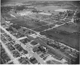
Part of Richards Studio Photographs
Aerial view of Tacoma General Hospital with Wright Park and surrounding neighborhoods.
Aerial photographs; Tacoma General Hospital (Tacoma); Wright Park (Tacoma);
Part of Richards Studio Photographs
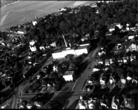
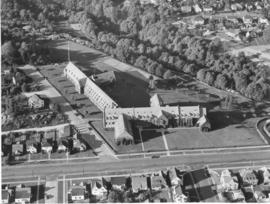
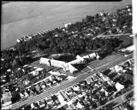
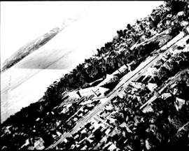
ca. 1938. Aerial view of North End Tacoma showing Annie Wright Seminary, surrounding neighborhood and Commencement Bay. The Tudor Gothic building was built in 1924 on a design by Sutton, Whitney & Dugan.
Aerial photographs; Private schools--Tacoma; Annie Wright Seminary (Tacoma)--Buildings;
Part of Richards Studio Photographs
Aerial view of North End Tacoma showing Annie Wright Seminary, surrounding neighborhood and Commencement Bay.
Aerial photographs; Private schools--Tacoma; Annie Wright Seminary (Tacoma)--Buildings;
Part of Richards Studio Photographs
Aerial view of North End Tacoma showing Annie Wright Seminary, surrounding neighborhood and Commencement Bay.
Aerial photographs; Private schools--Tacoma; Annie Wright Seminary (Tacoma)--Buildings;
Part of Richards Studio Photographs
Aerial view of North End Tacoma showing Annie Wright Seminary, surrounding neighborhood and Commencement Bay.
Aerial photographs; Private schools--Tacoma; Annie Wright Seminary (Tacoma)--Buildings;
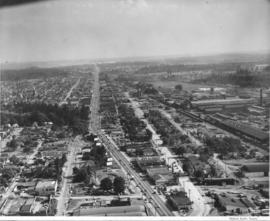
Part of Richards Studio Photographs
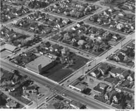
Aerial photograph of Sixth Avenue. This aerial photograph of Sixth Avenue near Union shows how the nearby streets are neatly partitioned into grids with well-kept homes and businesses. Near the center of the photograph is the new Tradewell supermarket #30 with its large tower jutting into the sky and expansive parking lot. On the next block a portion of the new Sixth & Washington Square Building can be seen. Photograph ordered by Carl Swanson, Tradewell Stores, Inc.
Aerial photographs; Tradewell Stores, Inc. (Tacoma); Sixth & Washington Square Building (Tacoma);
Part of Richards Studio Photographs
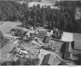
This was how Marymount Military Academy appeared from the air on July 28, 1953. The Academy was the only military school in Washington State. Located in what would now be Spanaway, the school was run by the Dominican Sisters, a Catholic teaching order. Young boys aged 6-16 were accepted for enrollment at this boarding school. Ground was broken at the site in July of 1922 and the school was dedicated in May of 1923. Built at a cost of $200,000 on the former "Shangarry" estate of J. Shields, Marymount originally was built in the Lombardine Mission style with modern gym, pool and infirmary. Enrollment was capped at 150 students; however, lessening enrollment and higher operating costs forced closure of the school in 1976. The property was purchased in the 1980's by Harold LeMay, who used much of it to house his antique car collection. TPL-9701
Aerial photographs; Marymount Military Academy (Spanaway); Private schools--Spanaway; Military education--Spanaway;
Part of Richards Studio Photographs
Aerial photographs. Several aerial photographs of the South Tacoma area were taken on behalf of North Pacific Bank in mid-June, 1953. This photo shows South Tacoma Way looking southward; even then, traffic was heavy on this major roadway. Businesses and homes dot the landscape with a noticeable amount of trees and foliage remaining. Old Tacoma Cemetary is believed to be on the left side of the photograph. TPL-6471
Aerial photographs; Neighborhoods--Tacoma--1950-1960;
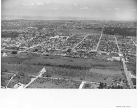
Part of Richards Studio Photographs
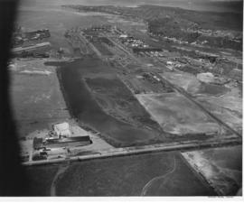
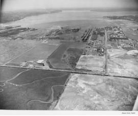
Aerial photographs. The South Tacoma area in the early 1950's was still vastly undeveloped. Aerial photographs shot on behalf of North Pacific Bank, based in South Tacoma, show large stretches of unoccupied land which remained heavily wooded. The Northern Pacific Railway shops can be seen about the middle of the picture on South 51st & Adams with the South Tacoma Air Park and Tyler Street nearby. TPL-2058
Aerial photographs; Neighborhoods--Tacoma--1950-1960; Northern Pacific Railway Co. (Tacoma);
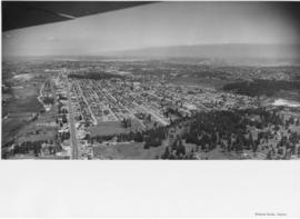
Part of Richards Studio Photographs
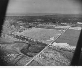
Aerial photographs. Photographs taken from an airplane in June, 1953, show the South Tacoma area as it was back then. Rows of homes and businesses are interspersed with stretches of unoccupied, wooded land. Surprisingly, there is little or no traffic on South 56th St., believed to be on the extreme right, quite unlike today. Photograph ordered by North Pacific Bank.
Aerial photographs; Neighborhoods--Tacoma--1950-1960;
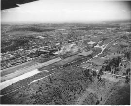
Part of Richards Studio Photographs
Aerial photographs. The wing of an airplane is visible as aerial photographs were taken of the South Tacoma and possibly other local areas on June 15, 1953. The photo appears to be looking north toward Vashon Island. There is a gravel pit to the right. There were still large areas of undeveloped and wooded land at this time in Tacoma's history. Photograph ordered by North Pacific Bank.
Aerial photographs; Neighborhoods--Tacoma--1950-1960;
Part of Richards Studio Photographs
Aerial photographs. A large number of photographs of the South Tacoma area were taken in one day by airplane on behalf of North Pacific Bank, which was based in that area. Multi-lane road is possibly South Tacoma Way with People's Warehouse on the right and possibly Vaughan Lumber towards the center. S 66th St. intersects towards the center of the photo with South Tacoma Way; Mount Tahoma High School would later be built on the undeveloped land nearby.
Aerial photographs; Neighborhoods--Tacoma--1950-1960;
Part of Richards Studio Photographs
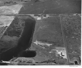
Aerial view of the Tacoma tideflats and Port of Tacoma. TPL-2251 Lincoln Ave. runs across the front of the photograph, with the Stauffer Chemical plant shown. The body of water in the center of the picture is the Port Industrial Waterway. East 11th Street runs between the waterway and Commencement Bay. The partially completed Port Industrial Waterway bridge can be seen, also the mothballed WWII baby flattops and the Port of Tacoma with its piers 1 & 2. The land curves around the right side of the picture ending in Browns Point.
Aerial views; Port of Tacoma (Tacoma)--1950-1960;
Part of Richards Studio Photographs
Aerial view of the Tacoma tideflats and Port of Tacoma. Lincoln Ave. runs up the left hand side of the picture and East 11th Street with its partially completed bridge on the right. The smaller body of water in the foreground is the Port Industrial Waterway, the one in the back is Hylebos Waterway and the large body of water on the right is Commencement Bay. The stored baby flattops and the Port of Tacoma can be seen on the right by the bridge. The vacant area is 1500 acres of vacant industrial land that the city hoped would turn Tacoma into the industrial center of the West.
Aerial views; Port of Tacoma (Tacoma)--1950-1960;
Part of Richards Studio Photographs
Aerial view of the Tacoma tideflats and Port of Tacoma. High tide. The road about halfway up the picture is East 11th Street as it crosses the Port Industrial Waterway. The partially completed bridge that opened in November of 1953 can be seen. In the left foreground of the picture are the baby flattops constructed for WWII and then stored here after the war. The Port of Tacoma Pier 1 lies to the right. Port of Tacoma Rd. runs from the Port to Lincoln Ave. The city of Tacoma had plans for all of the vacant land. They planned to fill it where needed and sell it to industries that needed deep water ports. TPL-2257
Aerial views; Port of Tacoma (Tacoma)--1950-1960;
Part of Richards Studio Photographs
Aerial photographs of the Port of Tacoma at low tide. The body of water is the Port Industrial Waterway, which was being promoted as a future deep water channel. The land lying to the right of the waterway was 1 1/2 miles of industrial land with deepwater access. The road in front of the waterway is East 11th Street, to the right is the Port of Tacoma Road and to the rear is Lincoln Ave. The area behind Lincoln Ave. was scheduled to be filled with the dirt dredged from the waterway and then sold to industries. Stauffer Chemical can be seen on Lincoln Ave. (2545 Lincoln Ave.) The partially completed Port Industrial Waterway bridge can be seen in the foreground of the picture.
Aerial views; Port of Tacoma (Tacoma)--1950-1960;
Part of Richards Studio Photographs
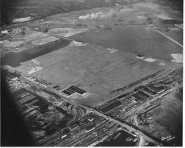
Aerial view of the Tacoma tideflats and Port of Tacoma. High tide. Prominent in the picture is the St. Paul and Tacoma Lumber Co. lying to the right of E. 11th Street in the foreground of the picture. Commencement Bay is to the left of 11th St., to the right is almost 1500 acres of vacant industrial land that Tacoma hoped to develop. The Port Industrial Waterway can be seen to the left rear of the picture. The city wanted to dredge this body of water for a deep water channel and collect premium prices for the vacant 1 1/2 miles of land lying beside it.
Aerial views; Port of Tacoma (Tacoma)--1950-1960;
Part of Richards Studio Photographs
Baby flat tops built in Tacoma during World War II are "mothballed" along the Port of Tacoma waterfront following the war alongside the Naval Storage area. Hooker Electrochemical Co. lies behind the Naval area (see the circular tanks.) The Port of Tacoma is in the front of the picture with its "finger pier." The partially completed Port Industrial Waterway bridge can be seen on the right hand side next to the flattops. TPL-2253.
Aerial views; Port of Tacoma (Tacoma)--1950-1960;
Part of Richards Studio Photographs
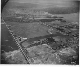
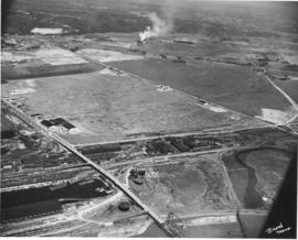
Aerial photographs of the Port of Tacoma at low tide. The body of water in the foreground of the picture with the log booms is the Puyallup Waterway. The following body of water is the Milwaukee Waterway. The road with the bridge is East 11th Street. Milwaukee Way runs at a right angle from 11th and crosses Lincoln Ave. The inland area beyond this point is mostly vacant with some scattered industries. Tacoma hoped to develop this 1500 acres into prime industrial area.
Aerial views; Port of Tacoma (Tacoma)--1950-1960;
Part of Richards Studio Photographs
This aerial view of the Tacoma tideflats and Port of Tacoma was taken in July of 1953. At the upper right of center a small fleet of baby flat tops built in Tacoma during World War II are "mothballed" in the Wapato (now Blair) Waterway next to the Tacoma naval station. The Port of Tacoma is to the left of the mothballed ships. Browns Point can be seen in the upper right corner. Commencement Bay can be seen lying beyond the Port. The two streets crossing the tideftats are East Eleventh Street and Lincoln Avenue (in the bottom half of the image). TPL-2259.
Aerial views; Port of Tacoma (Tacoma)--1950-1960;
Part of Richards Studio Photographs
Aerial view of the Tacoma tideflats and Port of Tacoma. TPL-2254. The intersection of Lincoln Ave. (right), Alexander and E. 11th Street (left). Port of Tacoma and Port Industrial Waterway visible. Photograph shows the 1500 acres of vacant land that the city of Tacoma hoped to sell to industries needing a deep water port.
Aerial views; Port of Tacoma (Tacoma)--1950-1960;
Part of Richards Studio Photographs
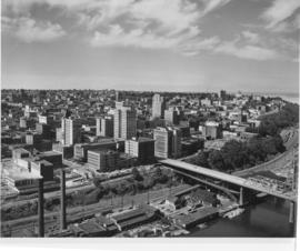
This is an aerial of downtown Tacoma looking west from 11th and A street as it appeared in August of 1953. Beginning span of the 11th Street Bridge at lower right corner and smoke stacks from Dock Street Steam plant at lower left.
Aerial photographs--1950-1960; Business districts--Tacoma--1950-1960; 11th Street Bridge (Tacoma); Bridges--Tacoma--1950-1960; Commercial streets--Tacoma--1950-1960;
Part of Richards Studio Photographs
Aerial of downtown Tacoma looking west up 11th Street from the Eleventh Street Bridge, taken on August 18, 1953.
Aerial photographs--1950-1960; Business districts--Tacoma--1950-1960; 11th Street Bridge (Tacoma); Bridges--Tacoma--1950-1960; Commercial streets--Tacoma--1950-1960;
Part of Richards Studio Photographs
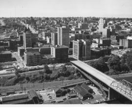
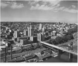
Aerial of downtown Tacoma looking west from the intersection of 11th & A Streets. The Dock Street Steam Plant can be seen in the left hand foreground and the Eleventh Street Bridge on the right. The Eleventh Street Bridge crosses the City Waterway and leads to the Tideflats and Port of Tacoma industrial areas.
Aerial photographs--1950-1960; Business districts--Tacoma--1950-1960; 11th Street Bridge (Tacoma); Commercial streets--Tacoma--1950-1960;
Part of Richards Studio Photographs
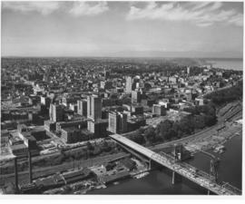
Aerial of downtown Tacoma looking west from the Eleventh Street Bridge. The Dock Street Steam Plant can be seen at lower left. Railroad tracks and a green belt divide the commercial downtown area from the waterfront. The bridge crosses over the City Waterway into the industrial area.
Aerial photographs--1950-1960; Business districts--Tacoma--1950-1960;
Part of Richards Studio Photographs
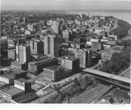
Aerial of downtown Tacoma looking west from the Eleventh Street Bridge. The bridge crosses the City Waterway and provides transportation from the commercial downtown area to the industrial area.
Aerial photographs--1950-1960; Business districts--Tacoma--1950-1960;
Part of Richards Studio Photographs
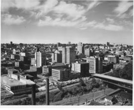
Aerial of downtown Tacoma looking west from the intersection of Eleventh and A streets.
Aerial photographs--1950-1960; Business districts--Tacoma--1950-1960;
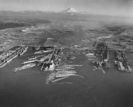
Part of Richards Studio Photographs
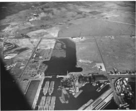
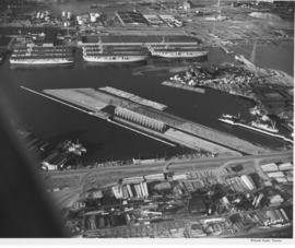
Aerials of the Port of Tacoma, circa 1954, with Mount Rainier in the background. From left to right lies the U.S. Naval Station with the mothballed fleet of flattops, kept in readiness, on the Port Industrial Waterway. The fingertip piers of the Port of Tacoma can also be seen on the Industrial Waterway. The Port of Tacoma grain elevators lie at the tip of land facing the Sitcum Waterway. The large, almost rectangular Sitcum Waterway holds many log booms. Tacoma Boat Building's tall sheds for drydock can be seen on the other side of the waterway. The smaller Milwaukee Waterway separates the Henry D. Gee Co. Grain Storage and the Puget Sound Freight Lines. TPL-2255
Aerial views; Port of Tacoma (Tacoma)--1950-1960; Rainier, Mount (Wash.); Port Industrial Waterway (Tacoma); Sitcum Waterway (Tacoma);
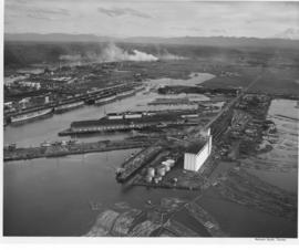
Part of Richards Studio Photographs
Aerials of the Port of Tacoma, c. 1954. The Port Industrial Waterway takes up most of the photograph with the mothballed WWII flattops stored in readiness for combat activation next to the U.S. Naval Station. The round storage tanks at Hooker Electrochemical can be seen behind the fleet of ships. The Port of Tacoma fingertip piers lie along the other side of the Waterway. The round storage tanks of Time Oil Co. and the Port of Tacoma Grain Elevators occupy the tip of land jutting out between the Port Industrial Waterway and the Sitcum Waterway. TPL-2250
Aerial views; Port of Tacoma (Tacoma)--1950-1960;