Aerial Photography

Taxonomy

Code

Scope note(s)

Source note(s)

Display note(s)

Hierarchical terms

Aerial Photography

Equivalent terms

Aerial Photography

Associated terms

Aerial Photography

824 Collections results for Aerial Photography

824 results directly related Exclude narrower terms

D109420-7

Aerial photographs- U.S. Oil Refinery. Aerial photographs of the U.S. Oil refinery were taken on October 3, 1957. The petroleum "tank farm" was located on an 120 acre site in the Tideflats. The light colored round cylinders shown in the photograph are probably the storage tanks. The refinery would be close to both rail and water transport. Photograph ordered by U.S. Oil & Refining Co.


Aerial photographs; Storage tanks--Tacoma; US Oil & Refining Co. (Tacoma);

D111635-2

Additional aerial photographs of the Tideflats area were requested by Malcolm McGhie and taken on January 3, 1958. Earlier photographs were taken about a month prior. Dash Point can be spotted protruding into the bay on the right with Vashon Island at the top of the photograph. St. Paul & Tacoma Lumber Co., who in August, 1957, became a subsidiary of St. Regis Paper Co., can be clearly seen towards the middle of the photograph including its loaf-shaped buildings. Its sawmill had provided 35% of the pulp mill's wood requirements. St. Regis is adjacent to its new subsidiary and to the upper right. The City Waterway is the body of water to the extreme left; new developments, with the removal of warehouses, shipbuilding, and mills nearly 45 years later have changed its landscape and revitalized the area.


Aerial photographs; St. Paul & Tacoma Lumber Co. (Tacoma); St. Regis Paper Co. (Tacoma)--1950-1960;

A111233-3

This aerial photograph of the St. Regis pulp mill looking toward Mt. Rainier was taken on behalf of Malcolm McGhie in December, 1957. The St. Regis plant was flanked by the Puyallup Waterway (L) and St. Paul Waterway (R) with the Middle Waterway to the extreme right. Smoke pours from the St. Regis plant facilities on a typical winter day; the plant employed multiple shifts so that operations could be conducted 24 hours a day, seven days a week. The multi-wall bag plant and kraft-pulp division are in the center of the photograph. The long narrow building is for kraft-pulp, adjoining the white-walled rectangular bag plant. The St. Paul & Tacoma Lumber Co. sawmill is in close proximity to the kraft pulp and paper mill. In August, 1957, St. Paul became an operating subsidiary of the St. Regis Paper Co. St. Paul had the largest retail lumber yard in the state of Washington. Its sawmill had furnished chips to St. Regis for a number of years, providing about 35% of the pulp mill's wood requirements. (TPL-5890, St. Regis Annual Report - 1957, p. 14-15)


Aerial photographs; St. Regis Paper Co. (Tacoma)--1950-1960; St. Paul & Tacoma Lumber Co. (Tacoma);

C112481-1

Copy of customer print. Aerial photographs of Seattle's Huntington Rubber Mills' facilities were taken in the spring of 1958. The smaller building in front may have been the office and the larger elongated buildings nestled close together, plant facilities. All three have semi-curved roofs. There were also two other buildings joined together to the left of the photograph. Photograph ordered by Huntington Rubber Mills.


Aerial photographs; Huntington Rubber Mills (Seattle);

A113921-5

This aerial view of Tacoma's commercial district was taken in April of 1958. Several log booms float at the south end of the Foss waterway just past the 15th St. Bridge. The tall smokestack near the center is the Dock St. steam plant. The other two bridges are the Railroad Bridge and the Murray Morgan Bridge. Several prominent buildings, including Old City Hall, Puget Sound National Bank, and the Washington Building, are visible. Among current landmarks that are missing: I-705, the Frank Russell Building, and the Columbia Bank Building. TPL-8467


Aerial photographs; Bridges--Tacoma--1950-1960; 11th Street Bridge (Tacoma); Logs;

A113921-4

Aerial photographs of the Puyallup River as it meanders through Tacoma were taken by Richards Studio on April 22, 1958. A close-up view of the three bridges over the river indicate that only the main bridge in the center had any traffic at the time the photograph was snapped. The bridge appears at a definite angle in this particular picture.


Aerial photographs; Bridges--Tacoma; Puyallup River (Wash.);

A113921-7

Aerial views of downtown Tacoma were taken on April 22, 1958. The busy commercial streets showcase many of the city's financial structures. Looking southeast in the center of the picture is Pacific Avenue with the Security Building (formerly Provident Building), the Ionic-columned Bank of California, Washington Building and Puget Sound National Bank, formerly the tallest building on the West Coast. The new Tacoma Building, Weyerhaeuser headquarters, and its predecessor are side-by-side on A Street, one street beyond, with the Perkins Building across the street.


Aerial photographs; Commercial streets--Tacoma--1950-1960; Security Building (Tacoma); Puget Sound National Bank (Tacoma); Bank of California National Association (Tacoma); Washington Building (Tacoma); Perkins Building (Tacoma);

A100333-1

Aerial view of Reichhold Chemical Co. on the Tideflats. Reichhold manufactured chemicals used by the plywood industry. Occupying 51 acres of land, the company was a large concern that would employ over 100 people.


Aerial photographs; Building construction; Reichhold Chemicals, Inc. (Tacoma);

A102546-4

Aerial of the Port of Tacoma, taken from over Commencement Bay heading into the Port. Tacoma can be seen as the forested area on the right dotted with buildings, with the Tideflats laying to the left of the bridge shrouded densely with industrial smoke.


Aerial views; Port of Tacoma (Tacoma)--1950-1960;

D105615-1

This aerial view of Tacoma's West End and the Tacoma Narrows Bridge was taken in March of 1957. 6th Avenue cuts upward through the center of the picture curving to the right as it feeds onto the Narrows Bridge. The road starting at the bottom right and running into 6th Ave. is Pearl Street, with the Tacoma Auto View Theater, 1202 North Pearl near the right edge. The buildings at the corner of 6th and Pearl are the early Highland Hills Shopping Center, 5915 6th Ave.. The bare land just above and to the right of the Auto View became the Highland Hills Golf Course.


Aerial photographs; Tacoma Narrows Bridge (Tacoma); Neighborhoods--Tacoma--1950-1960;

A93890-3

Aerial photographs of possibly military base were taken in November, 1955, on behalf of the law firm of Anderson, Pearson & Anderson. This may be on the grounds of Fort Lewis. There appears to be a church with steeple in the far left corner of the photograph. Other buildings appear to be temporary barracks.


Aerial photographs; Anderson, Pearson & Anderson (Tacoma);

D116584-10C

ca. 1958. Aerial view of newly built County-City Building, 930 Tacoma Avenue South, circa 1958, and surrounding neighborhood. The building would be dedicated in April of 1959. Directly behind its left wing is the venerable Pierce County Courthouse, 1012 South "G" St., soon to be demolished and ground transformed into parking for the County-City Building. At left lower corner is the Tacoma Public Library, 1102 Tacoma Avenue South.


Aerial views; Aerial photographs; County-City Building (Tacoma); Pierce County Courthouse (Tacoma); Tacoma Public Library (Tacoma); Streets--Tacoma--1950-1960; Commercial streets--Tacoma--1950-1960;

A116227-2

Educators Manufacturing Co., makers of school furniture, opened a new plant in the Tideflats area in 1958. Located at 3401 Lincoln Avenue, close to Taylor Way, the company shared the same address with Buffelen Woodworking & Buffelen Sales Co. The million dollar plant was located on a sprawling ten acre industrial site in the Tideflats. 133,000 square feet of plant space handled mass production of quality controlled classroom equipment. All production processes were located on one floor which reduced material handling cost. Hart Construction Co. were the general contractors. View of large plant, apparently divided into three sections, all with gently curved roofs. There is a large parking lot bordered by stacks of plywood. Washington Cooperative Farmers Feed Mill looms in the background. Photograph ordered by Educators Manufacturing Co. (TNT suppl. 11-9-58, p. 4) TPL-9831


Aerial photographs; Educators Manufacturing Co. (Tacoma); Furniture industry--Tacoma--1950-1960; Industrial facilities--Tacoma--1950-1960;

A116017-4

This aerial photograph, taken for Allied Owners, Inc. in August of 1958, shows the area of South Tacoma that would become home to the Tacoma Mall Shopping Center. The winding, twisting roads toward the lower center are the Lincoln Heights neighborhood. The road on the far right is South Pine. South 38th Street cuts through the middle of the photo from left to right. The tree covered area at right center is now the site of the Tacoma Mall. I-5 is yet to be built. At the top is Wapato Park and Wapato Lake.


Aerial photographs; Neighborhoods--Tacoma;

A116017-5

The South Tacoma area would be experiencing many changes in the late 1950's with the coming of the Tacoma Mall and the freeways. Aerial photographs taken for Allied Owners, Inc., on August 8, 1958, show the carefully laid out streets of the South Tacoma. It shows South 56th Street running from left to right across the center of the picture to the wooded area at the right, Wapato Hills. The church with the tall steeple in the left corner is the Church of Visitation on South 58th St. The area where the Tacoma Mall would eventually be built may have been in or close to the woods in the upper center of the photograph, next to the flat L shaped area.


Aerial photographs; Neighborhoods--Tacoma;

A116582-2

A new building was under construction at the large Pederson Fryer Farms complex at 2901 East 72nd when this aerial photograph was taken on September 7, 1958. The automatic poultry processing equipment at Pederson's had the capacity to dress and package 2,500 chickens per hour. At that time, Pederson's employed 88 people. The family personally supervised the raising of special hybrids and controlled their feeding and housing. By the 1990s they were Washington State's largest producer of poultry with 450 employees. After 48 years in the poultry business, Pederson Farms declared bankruptcy in 1996; they were bought out by Foster Farms of Modesto, California in 1997. Photograph ordered by Pederson Fryer Farms.


Aerial photographs; Pederson Fryer Farms (Tacoma);

A116893-2

The Richards Studio went aloft on a cloudy September 22, 1958, to take views of the Tacoma landscape. Smoke billows from the industrial Tideflats area. View of city's downtown area includes 11th St. Bridge, City (now Thea Foss) Waterway, heavily wooded Wright Park, and new County-City Building. Streets are neatly aligned with trees on most residential lots. The Tacoma Lawn Tennis Club can be spotted near the right lower corner with its unusual curved streets.


Aerial photographs; Tacoma Lawn Tennis Club (Tacoma);

A118700-23

This aerial photograph shows the original cloverleaf interchange at I-5 and 512 when it was under construction in January, 1959. The road cutting through from left to right is Hwy 99 right at the point where it changes from South Tacoma Way to being Pacific Hwy. SW. The houses at the bottom are part of the Southgate housing development. Southgate was a newer suburban park developed by Tacoma Master Builder Sherman Rowland which lay west of Hwy. 99. Plans were to build 300+ private homes in a park-like setting.


Aerial photographs; Neighborhoods--Lakewood--1950-1960; Housing developments--Lakewood--1950-1960; Express highways--Lakewood;

A118700-26

Aerial photographs were taken on New Year's Day, 1959, of the South End neighborhood in the vicinity of South 56th & Park Ave. This is 56th St. east of the new freeway which would carve out a section of the busy street. This area was already quite settled in the late 1950's. A new Safeway store would be built on South 56th St. just beyond Park Ave. to replace the Safeway on So. 54th & Sheridan, just off 56th St. The Moore branch of the Tacoma Public Library, on 56th close to Pacific Avenue and not visible in this photograph, would be completely rebuilt in 1988. Bethany Methodist Church and Clubhouse, the imposing buildings on Park near the top of the photograph, are still there. Traffic has increased substantially since 1959 on South 56th St.


Aerial photographs; Neighborhoods--Tacoma--1950-1960;

A119163-7

Closer view by air of the Seattle Huntington Rubber Mills plant. The elongated loaf-shaped buildings with dark stripes painted on the roofs were the Seattle plant of Huntington Rubber Mills. The plant was located at 34315 - 16th South, between two roadways. This area was still relatively sparsely populated in the late 1950's; there would probably have been more room for plant expansion if necessary. A large dirt or gravel pit is next door to the plant with forests to the rear. Photograph ordered by Huntington Rubber Mills.


Aerial photographs; Huntington Rubber Mills (Seattle);

A120358-59

ca. 1959. Aerial of Tacoma, circa 1959. Tacoma's downtown can be seen clearly in the center of the picture. The heavily forested area is Wright Park. The Eleventh Street Bridge crosses over the City (Foss) Waterway leading to the industrial development of the Tideflats. High above the city is the visage of Tacoma's most famous landmark, the white capped peaks of Mt. Rainier. A heavy haze lies over the city, either a weather condition or a visible reminder of the "aroma of Tacoma" air pollution. TPL-9299


Aerial photographs--1950-1960; Cityscapes--1950-1960; Wright Park (Tacoma); Rainier, Mount (Wash.);

A120358-64

ca. 1959. Circa 1959 aerial of downtown Tacoma. In the upper left center of the picture is the recently completed County-City building at 930 Tacoma Avenue South. To its left is the new (1952) Tacoma Public Library and the adjacent Carnegie library. To the rear of the County-City building, the old Pierce County Courthouse is partially demolished. Behind the County Courthouse is the Armory, which still stands today. To its left is the Tacoma Vocational School (now Bates.)


Aerial photographs--1950-1960; Commercial streets--Tacoma--1950-1960; County-City Building (Tacoma); Tacoma Public Library (Tacoma); State Armory (Tacoma); Pierce County Courthouse (Tacoma);

A120358-54

ca. 1959. Aerial of Tacoma, circa 1959. The lower portion of the picture shows the landscape covered with a residential blanket of single family homes. The high rise buildings of downtown can be seen left center of the picture with the Tideflats lying beyond. The snow capped peak of Mt. Rainier can be seen looming over the city, rising from a haze.


Aerial photographs; Rainier, Mount (Wash.); Neighborhoods--Tacoma--1950-1960;

A120358-49

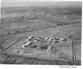
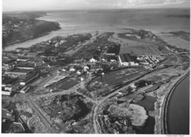
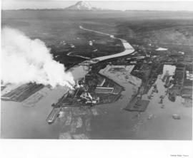
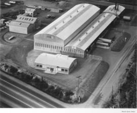
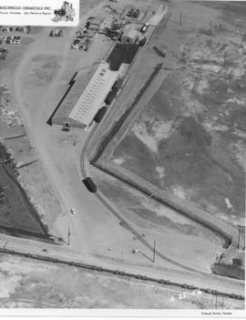
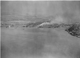
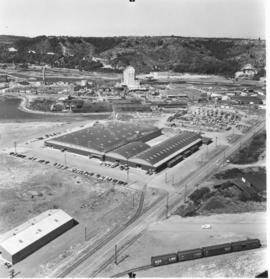
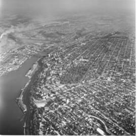
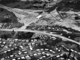
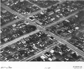
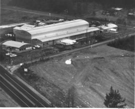
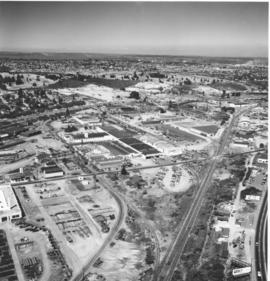
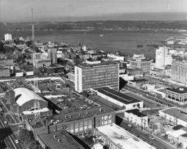
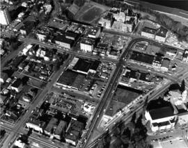
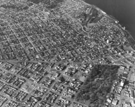
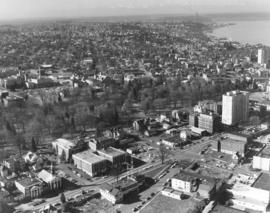
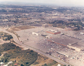
ca. 1959. Circa 1959 aerial of "Nalley Valley." All of the buildings in the center of the picture, to the left of the railroad tracks and above 35th Street which bisects the picture, belong to Marcus Nalley's vast food production empire. Marcus Nalley arrived in Ellis Island in 1903 at the age of 13 with 15 cents in his pocket. By the age of 21, with hard work and perseverance, he was working as a chef at one of Chicago's finest hotels. When he came to Tacoma, he brought with him a recipe for an Eastern delicacy "Saratoga Chips"- potato chips. By 1920, he had need of a factory to produce his chips, plus two new products of his design: Lumber Jack Syrup and Nalley's Mayonaise. His first factory opened at 409 Puyallup Ave. He guided his company and employees through the depression. By 1930, he set his sights on a 17 acre parcel on the outskirts of town. By the 1940's, his modern factory opened in that area that became known as "Nalley Valley." Marcus Nalley died in 1962 and his company was sold to the W.R. Grace Co. in 1966. It has changed ownership since that time, but "Nalley Valley" is still an important part of Tacoma's landscape. ("A History of Pierce County, Vol. 1")


Nalley Valley (Tacoma); Nalley's, Inc. (Tacoma); Food--Tacoma--1950-1960; Food industry--Tacoma--1950-1960; Aerial photographs;

D157046-10

Northerly aerial view of County-City Building and downtown business district taken on October 4, 1969. County-City Building is in center of photograph; the Washington National Guard Armory is separated from the County-City Building by large parking lot. Part of the Tacoma Public Library can be glimpsed across the street on Tacoma Ave. So. from the County-City Building. McDonald's and Central School are just north of the county and city offices. Medical Arts Building is Art Deco structure on Market far right of photograph. Commencement Bay is body of water with Brown's Point in background. Photograph ordered by Whitacre Engineers.


Aerial views; County-City Building (Tacoma); Tacoma Public Library (Tacoma); State Armory (Tacoma); Central School (Tacoma); McDonald's (Tacoma); Medical Arts Building (Tacoma); Parking lots--Tacoma--1960-1970;

D157837-31

Aerial view of Stadium District in early 1970. The French chateau-styled Stadium High School and adjacent Stadium Bowl are near the top of the photograph on North "E" St. One street below is Tacoma Avenue; the white tower on the upper left corner is the Vista Manor Apartments, 319 Tacoma Avenue North. Further south on Tacoma Avenue (right lower edge) is the First Presbyterian Church with its ornate dome extending from the red brick structure. A small wedge of Wright Park is close by. The streets running vertically and intersecting Tacoma Ave. are 3rd, 2nd, and 1st; Division runs rather diagonally near the right side where it also intersects Tacoma Ave. Photograph ordered by Puget Sound National Bank.


Aerial views; Neighborhoods--Tacoma--1970-1980; First Presbyterian Church (Tacoma); Wright Park (Tacoma); Stadium High School (Tacoma); Stadium Bowl (Tacoma); Vista Manor Apartments (Tacoma);

D157837-7

1970 Aerial view of North end neighborhoods surrounding Wright Park including the Stadium District. A wedge of Commencement Bay is toward the upper right corner of the picture. Stadium High School and Stadium Bowl are close to the right edge. Garfield Park, located next to Annie Wright Seminary, is the wooded area near the top of the photograph. Photograph ordered by Puget Sound National Bank.


Aerial views; Neighborhoods--Tacoma--1970-1980; Wright Park (Tacoma); Commencement Bay (Wash.); Stadium High School (Tacoma); Stadium Bowl (Tacoma); Garfield Park (Tacoma); Annie Wright Seminary (Tacoma)--1970-1980;

D157837-30

A series of photographs were taken by air on February 20, 1970, featuring north end neighborhoods, including the Stadium District. This view focuses on Wright Park, and the businesses and apartments surrounding the park. Located about Sixth & "I," Wright Park provided a peaceful alternative to the bustle of urban living. Through the trees can be seen a glimpse of the First Church of Christ, Scientist at the corner of Division and "I" and Tacoma General Hospital's facilities on nearby "K" (now Martin Luther King Jr. Way). A section of tranquil Commencement Bay is on the right upper edge. Photograph ordered by Puget Sound National Bank.


Aerial views; Neighborhoods--Tacoma--1970-1980; Wright Park (Tacoma); First Church of Christ, Scientist (Tacoma); Tacoma General Hospital (Tacoma); Commencement Bay (Wash.);

D157659-2C

Aerial photograph of Tacoma Mall Shopping Center and vicinity in 1969. The area around the Tacoma Mall Shopping Center looked quite different in 1969 as the mall had not expanded to the size it holds in 2006. This view is taken looking across South 48th St. towards the mall with Penney's, Pay Less Drugs, and Nordstrom Best clearly visible. The Bon Marche (now Macy's) is the large red building in back of Nordstrom. The Tacoma Mall Office Building is off to its left and had recently opened. Best Buy and BabiesRus would later be built in the wooded area across So. 48th St. Pine St., which intersects So. 48th St., would later become more developed as the Post Office would build the Evergreen Station closer to So. 38th. The White Front store with large parking lot is already on So. 38th where Michael's would later be situated. In the distance toward the top center of the photograph is the Public Utilities building on So. 35th near Union Ave. Color photograph ordered by Center Offices, Inc.


Aerial views; Tacoma Mall Shopping Center (Tacoma); Shopping centers--Tacoma; Tacoma Mall Office Building (Tacoma); J.C. Penney Co. (Tacoma); Department stores--Tacoma--1960-1970; Pay Less Drugs (Tacoma); Nordstrom Best (Tacoma); White Front (Tacoma);

Results 61 to 90 of 824