Aerial Photography

Taxonomy

Code

Scope note(s)

Source note(s)

Display note(s)

Hierarchical terms

Aerial Photography

Equivalent terms

Aerial Photography

Associated terms

Aerial Photography

824 Collections results for Aerial Photography

824 results directly related Exclude narrower terms

A63231-1

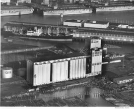
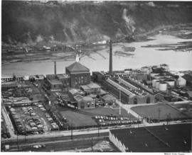
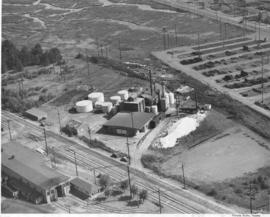
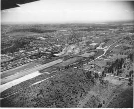
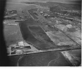
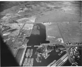
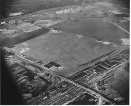
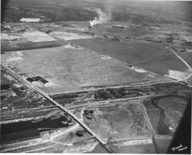
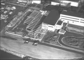
Aerial photograph to show the steel work on a new building at St. Regis, Tacoma. Construction of a bag plant at the St. Regis Paper company started in June 1951 with the driving of piling as the first step. The addition was built of steel and concrete and would be used for the production of industrial-use bags for cement, fertilizer and other materials needing heavy-duty holders. When completed, this plant would replace the leased plant at Seattle. (TNT 6/15/1951; St. Regis Paper Company 1951 Annual Report)


St. Regis Paper Co. (Tacoma)--1950-1960; Progress photographs; Building construction--Tacoma--1940-1950; Aerial photographs; Paper industry--Tacoma--1950-1960;

A63168-1

An aerial view of the Narrowmoor Addition, a subdivision west of Jackson Avenue. Ordered by Burton W. Lyon, Jr., Puget Sound Bank Building.


Aerial photographs; Housing developments--Tacoma; Land subdivision--Tacoma; Land use--Tacoma; Real estate development--Tacoma;

A63168-2

An aerial view of the Narrowmoor Addition, a subdivision west of Jackson Avenue. Ordered by Burton W. Lyon, Jr., Puget Sound Bank Building.


Aerial photographs; Housing developments--Tacoma; Land subdivision--Tacoma; Land use--Tacoma; Real estate development--Tacoma;

A63168-4

An aerial view of the Narrowmoor Addition, a subdivision west of Jackson Avenue between Sixth and 19th Avenues. The Narrows portion of Puget Sound is below, to the west. The ferry dock at the base of Sixth Avenue can be seen on the left. Ordered by Burton W. Lyon, Jr., Puget Sound Bank Building.


Aerial photographs; Housing developments--Tacoma; Land subdivision--Tacoma; Land use--Tacoma; Real estate development--Tacoma;

A63233-1

16 new elevators have been added to the existing elevators at the Port of Tacoma. The project added 500,000 bushels to the Port's capacity. Baby flattops (smaller aircraft carriers) are seen across the Port Industrial Waterway. The grain elevators had a 2 million bushel capacity by 1954. They could receive up to 100 cars per day, with 3 receiving legs. Two shipping legs provided shop delivery at a maximum rate of 30,000 bushels per hour. Rail facilities provided for 50 cars to be at the unloading track. There was also a 50 ton hydraulic automatic grain truck dumper. The first pier behind the elevators was Pier 1 and the next one (with a docked ship) was Pier 2. The Port Industrial Waterway was renamed the Blair Waterway in 1970, in honor of past Port of Tacoma Commissioner A.E. Blair. (Tacoma brochure: "Port of Tacoma...Invitation to Industry") (pier identification provided by a reader)


Aerial photographs; Port of Tacoma (Tacoma)--1950-1960; Grain elevators--Tacoma--1950-1960; Aircraft carriers--Tacoma--1940-1950; Harbors--Tacoma; Marine terminals--Tacoma--1940-1950; Shipping--Tacoma--1940-1950;

A63895-1

An aerial view of the plant facility for Hooker Electrochemical Company located at 605 Alexander Avenue on the Tacoma tideflats. The Hylebos Waterway provided excellent accessibility with a company dock and a railroad spur running through the facility enhanced transportation even further. The Port of Tacoma sold an additional 20-acre site to Hooker Electrochemical in December 1951 for $56,400 according to George Osgood, manager of the Port. The property, including a 1,200-foot frontage on the Port-Industrial waterway, was to be used for further expansion of the chemical firm's Tacoma plant. (TNT, 12/16/1951, p.1)


Aerial photographs; Hooker Electrochemical Co. (Tacoma); Logs; Hylebos Waterway (Tacoma); Harbors--Tacoma; Factories--Tacoma--1940-1950; Chemical industry--Tacoma--1950-1960;

C72770-1

Copy of undated aerial photograph of the City of Tacoma as mosiaclike map was made for a sample book. TPL-8739


Aerial photographs; Maps;

A72491-1

ca. 1953. An undated aerial photograph of the industrial Tacoma Tideflats area shows a majestic view of snow-capped Mount Rainier looming in the background. Shaffer Terminals are on the right hand side of City Waterway; the waterway is now known as the Thea Foss Waterway. Shell Oil facilities are probably across from Shaffer's.


Aerial photographs; Rainier, Mount (Wash.); Waterfronts;

A71928-1

Aerial views of Rainier State School in Buckley were taken in late December, 1952, at a height of 800-1000 feet. Rainier School had experienced severe overcrowding in the late 1940's and was forced to request nearly $6,500,000 in aid from state and federal sources to alleviate the housing crunch. Rainier School was only one of two specialized state schools in Washington State and had long waiting lists. It boarded physically and mentally handicapped children, and by the early 1950's, had an enrollment of nearly 2000.


Aerial photographs; Western State Custodial School (Buckley); Institutional care--Buckley; Children--Health & welfare

A71928-3

Mount Rainier looms over the sprawling campus of the Rainier State School in Buckley in December of1952. This aerial photograph, taken at a height of 800-1000 feet, shows the large institution and the rural landscape that surrounded it. The Rainier School, which housed mentally and physically handicapped children, experienced severe overcrowding during the late 1940's to early 1950's.


Aerial photographs; Western State Custodial School (Buckley); Institutional care--Buckley; Children--Health & welfare; Rainier, Mount (Wash.);

A68175-A

An aerial view of Philadelphia Quartz' plant on the Tacoma tideflats. Belgian silica sand and California soda ash were chemically combined to provide a product sold largely in Tacoma but marketed also in other Northwest cities. Silicate of soda, water-glass to farm households, was used in adhesives for the plywood industry and corrugated paper-board for the container industry.


Chemical industry--Tacoma--1950-1960; Minerals; Philadelphia Quartz Co. of California (Tacoma); Aerial photographs;

D77321-6

Aerial of downtown Tacoma looking west from the Eleventh Street Bridge. The Dock Street Steam Plant can be seen at lower left. Railroad tracks and a green belt divide the commercial downtown area from the waterfront. The bridge crosses over the City Waterway into the industrial area.


Aerial photographs--1950-1960; Business districts--Tacoma--1950-1960;

D77321-1

This is an aerial of downtown Tacoma looking west from 11th and A street as it appeared in August of 1953. Beginning span of the 11th Street Bridge at lower right corner and smoke stacks from Dock Street Steam plant at lower left.


Aerial photographs--1950-1960; Business districts--Tacoma--1950-1960; 11th Street Bridge (Tacoma); Bridges--Tacoma--1950-1960; Commercial streets--Tacoma--1950-1960;

D77321-8

Aerial of downtown Tacoma looking west from the intersection of Eleventh and A streets.


Aerial photographs--1950-1960; Business districts--Tacoma--1950-1960;

D77321-7

Aerial of downtown Tacoma looking west from the Eleventh Street Bridge. The bridge crosses the City Waterway and provides transportation from the commercial downtown area to the industrial area.


Aerial photographs--1950-1960; Business districts--Tacoma--1950-1960;

D77321-2

Aerial of downtown Tacoma looking west up 11th Street from the Eleventh Street Bridge, taken on August 18, 1953.


Aerial photographs--1950-1960; Business districts--Tacoma--1950-1960; 11th Street Bridge (Tacoma); Bridges--Tacoma--1950-1960; Commercial streets--Tacoma--1950-1960;

D77321-4

Aerial of downtown Tacoma looking west from the intersection of 11th & A Streets. The Dock Street Steam Plant can be seen in the left hand foreground and the Eleventh Street Bridge on the right. The Eleventh Street Bridge crosses the City Waterway and leads to the Tideflats and Port of Tacoma industrial areas.


Aerial photographs--1950-1960; Business districts--Tacoma--1950-1960; 11th Street Bridge (Tacoma); Commercial streets--Tacoma--1950-1960;

D75872-77

Aerial photographs. The wing of an airplane is visible as aerial photographs were taken of the South Tacoma and possibly other local areas on June 15, 1953. The photo appears to be looking north toward Vashon Island. There is a gravel pit to the right. There were still large areas of undeveloped and wooded land at this time in Tacoma's history. Photograph ordered by North Pacific Bank.


Aerial photographs; Neighborhoods--Tacoma--1950-1960;

D75943-14

Aerial view of the Tacoma tideflats and Port of Tacoma. Lincoln Ave. runs up the left hand side of the picture and East 11th Street with its partially completed bridge on the right. The smaller body of water in the foreground is the Port Industrial Waterway, the one in the back is Hylebos Waterway and the large body of water on the right is Commencement Bay. The stored baby flattops and the Port of Tacoma can be seen on the right by the bridge. The vacant area is 1500 acres of vacant industrial land that the city hoped would turn Tacoma into the industrial center of the West.


Aerial views; Port of Tacoma (Tacoma)--1950-1960;

D75453-3

This was how Marymount Military Academy appeared from the air on July 28, 1953. The Academy was the only military school in Washington State. Located in what would now be Spanaway, the school was run by the Dominican Sisters, a Catholic teaching order. Young boys aged 6-16 were accepted for enrollment at this boarding school. Ground was broken at the site in July of 1922 and the school was dedicated in May of 1923. Built at a cost of $200,000 on the former "Shangarry" estate of J. Shields, Marymount originally was built in the Lombardine Mission style with modern gym, pool and infirmary. Enrollment was capped at 150 students; however, lessening enrollment and higher operating costs forced closure of the school in 1976. The property was purchased in the 1980's by Harold LeMay, who used much of it to house his antique car collection. TPL-9701


Aerial photographs; Marymount Military Academy (Spanaway); Private schools--Spanaway; Military education--Spanaway;

D75943-6

This aerial view of the Tacoma tideflats and Port of Tacoma was taken in July of 1953. At the upper right of center a small fleet of baby flat tops built in Tacoma during World War II are "mothballed" in the Wapato (now Blair) Waterway next to the Tacoma naval station. The Port of Tacoma is to the left of the mothballed ships. Browns Point can be seen in the upper right corner. Commencement Bay can be seen lying beyond the Port. The two streets crossing the tideftats are East Eleventh Street and Lincoln Avenue (in the bottom half of the image). TPL-2259.


Aerial views; Port of Tacoma (Tacoma)--1950-1960;

D75943-8

Aerial view of the Tacoma tideflats and Port of Tacoma. TPL-2254. The intersection of Lincoln Ave. (right), Alexander and E. 11th Street (left). Port of Tacoma and Port Industrial Waterway visible. Photograph shows the 1500 acres of vacant land that the city of Tacoma hoped to sell to industries needing a deep water port.


Aerial views; Port of Tacoma (Tacoma)--1950-1960;

D75872-70

Aerial photographs. Photographs taken from an airplane in June, 1953, show the South Tacoma area as it was back then. Rows of homes and businesses are interspersed with stretches of unoccupied, wooded land. Surprisingly, there is little or no traffic on South 56th St., believed to be on the extreme right, quite unlike today. Photograph ordered by North Pacific Bank.


Aerial photographs; Neighborhoods--Tacoma--1950-1960;

D75872-79

Aerial photographs. A large number of photographs of the South Tacoma area were taken in one day by airplane on behalf of North Pacific Bank, which was based in that area. Multi-lane road is possibly South Tacoma Way with People's Warehouse on the right and possibly Vaughan Lumber towards the center. S 66th St. intersects towards the center of the photo with South Tacoma Way; Mount Tahoma High School would later be built on the undeveloped land nearby.


Aerial photographs; Neighborhoods--Tacoma--1950-1960;

D75872-59

Aerial photographs. The South Tacoma area in the early 1950's was still vastly undeveloped. Aerial photographs shot on behalf of North Pacific Bank, based in South Tacoma, show large stretches of unoccupied land which remained heavily wooded. The Northern Pacific Railway shops can be seen about the middle of the picture on South 51st & Adams with the South Tacoma Air Park and Tyler Street nearby. TPL-2058


Aerial photographs; Neighborhoods--Tacoma--1950-1960; Northern Pacific Railway Co. (Tacoma);

D75943-12

Aerial view of the Tacoma tideflats and Port of Tacoma. TPL-2251 Lincoln Ave. runs across the front of the photograph, with the Stauffer Chemical plant shown. The body of water in the center of the picture is the Port Industrial Waterway. East 11th Street runs between the waterway and Commencement Bay. The partially completed Port Industrial Waterway bridge can be seen, also the mothballed WWII baby flattops and the Port of Tacoma with its piers 1 & 2. The land curves around the right side of the picture ending in Browns Point.


Aerial views; Port of Tacoma (Tacoma)--1950-1960;

D75943-16

Aerial view of the Tacoma tideflats and Port of Tacoma. High tide. The road about halfway up the picture is East 11th Street as it crosses the Port Industrial Waterway. The partially completed bridge that opened in November of 1953 can be seen. In the left foreground of the picture are the baby flattops constructed for WWII and then stored here after the war. The Port of Tacoma Pier 1 lies to the right. Port of Tacoma Rd. runs from the Port to Lincoln Ave. The city of Tacoma had plans for all of the vacant land. They planned to fill it where needed and sell it to industries that needed deep water ports. TPL-2257


Aerial views; Port of Tacoma (Tacoma)--1950-1960;

D75943-22

Aerial view of the Tacoma tideflats and Port of Tacoma. High tide. Prominent in the picture is the St. Paul and Tacoma Lumber Co. lying to the right of E. 11th Street in the foreground of the picture. Commencement Bay is to the left of 11th St., to the right is almost 1500 acres of vacant industrial land that Tacoma hoped to develop. The Port Industrial Waterway can be seen to the left rear of the picture. The city wanted to dredge this body of water for a deep water channel and collect premium prices for the vacant 1 1/2 miles of land lying beside it.


Aerial views; Port of Tacoma (Tacoma)--1950-1960;

D75943-4

Aerial photographs of the Port of Tacoma at low tide. The body of water in the foreground of the picture with the log booms is the Puyallup Waterway. The following body of water is the Milwaukee Waterway. The road with the bridge is East 11th Street. Milwaukee Way runs at a right angle from 11th and crosses Lincoln Ave. The inland area beyond this point is mostly vacant with some scattered industries. Tacoma hoped to develop this 1500 acres into prime industrial area.


Aerial views; Port of Tacoma (Tacoma)--1950-1960;

D75872-24

Aerial photographs. Several aerial photographs of the South Tacoma area were taken on behalf of North Pacific Bank in mid-June, 1953. This photo shows South Tacoma Way looking southward; even then, traffic was heavy on this major roadway. Businesses and homes dot the landscape with a noticeable amount of trees and foliage remaining. Old Tacoma Cemetary is believed to be on the left side of the photograph. TPL-6471


Aerial photographs; Neighborhoods--Tacoma--1950-1960;

Results 61 to 90 of 824