Aerial Photography

Taxonomy

Code

Scope note(s)

Source note(s)

Display note(s)

Hierarchical terms

Aerial Photography

Equivalent terms

Aerial Photography

Associated terms

Aerial Photography

824 Collections results for Aerial Photography

824 results directly related Exclude narrower terms

D137300-138

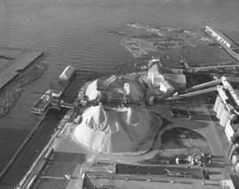
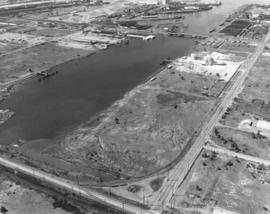
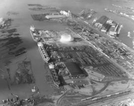
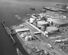
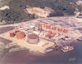
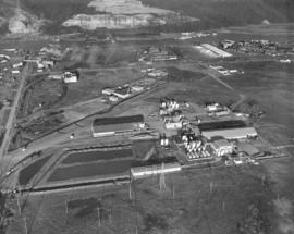
Another view of Reichhold Chemicals plant, including ponds, storage tanks and outer buildings, taken by air on March 29, 1963. Reichhold's had purchased 51 acres of land in the Tideflats in 1956 so that the national producer of chemicals had plenty of room for expansion. They were originally located at 3320 Lincoln Avenue but by 1963 had apparently moved to 2340 Taylor Way. TPL-6579


Aerial photographs; Reichhold Chemicals, Inc. (Tacoma); Chemical industry--Tacoma--1960-1970;

D137612-3

These mounds look like enormous scoops of sand but they are really piles of pulp- mill chips located at St. Regis Paper Co.'s Tacoma kraft mill. As seen by air on February 9, 1963, two barges full of chips are being unloaded for use by St. Regis. St. Regis had started to purchase in large quantities chips from waterside suppliers as far away as British Columbia in addition to purchasing locally. Thus, chips were now being received by water, truck and rail. Photograph also shows log booms saved for future use. Photograph ordered by Malcolm McGhie, industrial consultant, New York.(1964 St. Regis Annual Report, p. 11)


Aerial photographs; St. Regis Paper Co. (Tacoma)--1960-1970; Paper industry--Tacoma--1960-1970; Logs;

D137300-125C

ca. 1963. Vista Manor with Stadium H.S. in background. Color 1963 aerial photograph of Tacoma's north end focusing on the 16-story Vista Manor Apartments and Central Lutheran Church on Tacoma Avenue North and Washington State Historical Building, Stadium Bowl and Stadium High School on bluff overlooking Commencement Bay. Tideflats in distance. One ship is docked below the school.


Aerial photographs; Stadium Bowl (Tacoma); Stadium High School (Tacoma); Washington State Historical Building (Tacoma); Neighborhoods--Tacoma--1960-1970; Central Lutheran Church (Tacoma); Vista Manor Apartments (Tacoma);

D137300-127C

ca. 1963. Stadium High School on Stadium Way enjoyed elevated views of Commencement Bay. This 1963 aerial photograph shows the school's proximity to the Washington State Historical Society Building juxtaposed with massive Stadium Bowl, site of football and civic endeavors. Stadium High School had been planned as a grand Tacoma hotel but it was gutted by fire before completion. It opened as a high school in 1906 and changed its name to Stadium in 1913. The school will be undergoing extensive remodeling starting in 2004 and its students transferred to the old Mount Tacoma High School.


Aerial photographs; Stadium High School (Tacoma); Washington State Historical Building (Tacoma); Washington State Historical Society (Tacoma); Neighborhoods--Tacoma--1960-1970;

D137300-87

ca. 1963. Closer look at the Milton water tank and surrounding homes and farms via air in 1963.


Aerial photographs; Water tanks--Milton;

A115843-4

Additional aerial photographs of the Lakewood area surrounding the Villa Plaza Shopping Center were taken by the Richards Studio for a sample book on August 5, 1958. Lakewood was a fast growing community in the 1950's and the developers of the Villa Plaza filled a niche for a large one-stop shopping center. There was plenty of parking available, enough for 4000 cars, and apparently room for further expansion of the center. Aerial photographs of that time showed that there were neatly laid out streets with many trees. Lots were probably larger and less expensive than those within Tacoma city limits. The remodeled Lakewood Center, a smaller shopping center that was Lakewood's first, is almost directly in the center of the picture above the Villa Plaza. TPL-8319


Aerial photographs; Villa Plaza Shopping Center (Lakewood); Shopping centers--Lakewood--1950-1960; Neighborhoods--Lakewood--1950-1960;

D139204-3

Aerial view of the Port Industrial waterway taken in late August, 1963, with industrial facilities close by. 11th St. runs horizontally over the waterway. Bridge is the Blair Bridge. Photograph ordered by Port of Tacoma. TPL-2248


Aerial photographs; Port Industrial Waterway (Tacoma);

D140600-327

1964 stock footage. Aerials taken on July 24, 1964, looking toward Tacoma from over Sumner. Hylebos Waterway to extreme right. Other notable water features are the City (now Thea Foss) Waterway, meandering Puyallup River, and Port Industrial Waterway. Wooded Point Defiance near top of photograph. Fox Island left corner.


Aerial photographs; Hylebos Waterway (Tacoma); Puyallup River (Wash.);

D140419-1

Aerial photographs of the Lakewood area were taken on December 21, 1963, at the request of Puget Sound National Bank. This is reportedly the area between 84th and Ponders Station. Lakewood neighborhoods to the left would include Villa Plaza Shopping Center and Clover Park High School. The three large lakes are: Steilacoom, Gravelly and American Lake; Tacoma Country & Golf Club is on the shores of American Lake. McChord AFB to the right of I-5. TPL-9304


Aerial photographs; Neighborhoods--Lakewood--1960-1970; American Lake (Wash.); Lake Steilacoom (Wash.); Gravelly Lake (Wash.);

D140600-30

Aerial stock footage, February, 1964, of area near the upcoming Tacoma Mall. King's Hilltop Drive-In, upper right, is on So. 38th St. close to I-5. Eventually the large wooded area would become filled with businesses and parking lots associated with the Mall.


Aerial photographs; Shopping centers--Tacoma--1960-1970;

D159700-242C

1971 color Richards stock footage. Aerial of Division and N. Yakima neighborhood. This view is taken almost directly overhead the three apartment houses: Casablanca, Rutland and Woodstock (l-r) on May 27, 1971. The Casablanca and Rutland apartments were on N. Yakima while the Woodstock's address was actually on N. 1st. The Casablanca was the youngest of the three, built in 1944, while the Rutland and Woodstock were erected in the early 1900s. The building with grey roof and brownish-red trim up the street from the apartments is Walker Chevrolet. It is unknown whether the car-filled lot behind the apartments was for tenant parking or used partially by the car dealership. Major streets in this area are N. Yakima in front of the three apartment houses and 1st St. which veers from Division (farthest right).


Aerial views; Casablanca Apartments (Tacoma); Rutledge Apartments (Tacoma); Woodstock Apartments (Tacoma); Apartment houses--Tacoma; Walker Chevrolet Co. (Tacoma);

D159700-181C

ca. 1971. 1971 Richards stock footage. Aerial photograph of the City of Tacoma in 1971, with emphasis on the downtown business district and City Waterway (now Thea Foss Waterway). Buildings closest to the waterway and the 11th Street Bridge (now Murray Morgan Bridge) include the Perkins and Tacoma Buildings that flank the bridge, the new Pacific National Bank of Washington Plaza tower, the Rust and Washington Buildings. Also visible are the Medical Arts Building (now Municipal Building) and further in the background, the County-City Building. Two new parking garages on Pacific Ave. were completed in 1970-71 providing hundreds of parking spaces and addressing the pleas for more parking stalls.


Aerial views; City Waterway (Tacoma); Cityscapes; 11th Street Bridge (Tacoma); Perkins Building (Tacoma); Tacoma Building (Tacoma); Pacific National Bank of Washington (Tacoma); Rust Building (Tacoma); Washington Building (Tacoma);

D159700-183C

ca. 1971. 1971 color Richards stock footage. Aerial view of downtown business district featuring the new Bank of Washington Plaza with its 24-story tower. Directly across Pacific Avenue from the new skyscraper is the Park Plaza South parking garage, also recently opened with 381 parking stalls. To the left of the Pacific National Bank's Bank of Washington Plaza is the familiar spire of Puget Sound National Bank, once the tallest structure on the West Coast. Also in view is the City (now Thea Foss) Waterway with the 11th St. Bridge (now Murray Morgan Bridge). The Tacoma Building and Perkins Building flank the bridge. TPL-2316


Aerial views; Pacific National Bank of Washington (Tacoma); Puget Sound National Bank (Tacoma); Banks--Tacoma; Parking garages--Tacoma--1970-1980; 11th Street Bridge (Tacoma); Tacoma Building (Tacoma); Perkins Building (Tacoma); City Waterway (Tacoma);

D150900-358

1967 Richards stock file. Aerial view of new Kmart department store, 5132 Sixth Ave., with nearly full parking lot, taken on October 28, 1967. Kmart was located next to Busch's Sixth Ave. Drive-in and across the street from the First Christian Church. G. Kirkebo & Sons were general contractors; architect was E.D. McCarthy of Spokane. The 105,000 square foot building was situated on a 10.5 acre site with parking for 1000 cars. (TNT 1-23-67, p. 7)


Aerial photographs; Kmart (Tacoma); Department stores--Tacoma--1960-1970; First Christian Church (Tacoma); Busch's Sixth Avenue Drive-In Restaurant (Tacoma);

D150900-352

1967 Richards stock file. Aerial photographs of the University Place neighborhoods surrounding 40th & Bridgeport Way were taken on October 28, 1967. This area was still heavily wooded. Building complex on the right side of photograph is the University Village Shopping Center which was scheduled to open in October, 1967. Food King supermarket and Don's Village Drugs would be major clients of the shopping center. At the bottom of the photograph is the University Place water tower which had been remodeled in 1964 to hold 400,000 gallons.


Aerial photographs; Neighborhoods--University Place; Shopping centers--University Place; Food King (University Place); Water towers--University Place;

D150900-367

1967 Richards stock footage. Aerial view of Port of Tacoma's Pier 7 in the Tacoma Tideflats. Dome is the 242-feet in diameter Kaiser Dome which stored alumina ore. Alumina moving out the dome could be loaded directly into railroad hopper cars. The three main means of transporting Tacoma's industrial products, rail, water and highways, converge in this October 28, 1967, photograph. (TNT 6-23-67, p. 7)


Aerial photographs; Storage tanks--Tacoma; Logs; Railroad freight cars--Tacoma--1960-1970; Cargo ships--Tacoma--1960-1970; Piers & wharves--Tacoma--1960-1970;

D150900-231

1967 Richards stock file. Another aerial view of the Tidewater Oil Co. facilities on East D St. in the tideflats taken on June 15, 1967. The plant was located next to Puget Sound Plywood Co. whose rooftop sign can be readily seen. The plywood company's log dumps appear to be encrouching onto Tidewater Oil premises. Tidewater had large piers which made transport and transfer of its products onto ships an easier task.


Aerial photographs; Tidewater Oil Co. (Tacoma); Industrial facilities--Tacoma--1960-1970; Storage tanks--Tacoma; Puget Sound Plywood, Inc. (Tacoma); Logs; Piers & wharves--Tacoma--1960-1970;

D150900-111

1967 Richards stock file. Aerial view of Tacoma's waterfront taken on April 11, 1967. Familiar city landmarks are the heavily wooded Wright Park in left-center; 11th Street Bridge crossing the City (now Thea Foss) Waterway; County-City Building in lower-center; St. Regis Paper Co. plant in the Tideflats industrial area with smoke billowing from its many stacks; and the dark waters of Commencement Bay.


Aerial photographs; Waterfronts--Tacoma--1960-1970; Wright Park (Tacoma); 11th Street Bridge (Tacoma); County-City Building (Tacoma); St. Regis Paper Co. (Tacoma)--1960-1970; Smoke--Tacoma; Commencement Bay (Wash.);

D151508-1

Aerial photograph of J.M. Martinac Shipbuilding facility taken on April 11, 1967. The shipbuilding's namesake is docked nearby. The 154-foot tuna boat was the fifth tuna seiner built for Lou Brito of San Diego who had developed a close working relationship with Joe Martinac. Mr. Martinac's mother christened the ship. The J.M. Martinac was the largest seiner ever built by Martinac Shipbuilding. West Coast Grocery Co. can be seen in background. Photograph ordered by J.M. Martinac Shipbuilding. (TNT 2-19-67, B-4, TNT 3-28-67, A-1) TPL-9123


Aerial photographs; J.M. Martinac Shipbuilding Corp. (Tacoma); Boat & ship industry--Tacoma--1960-1970; Fishing boats--Tacoma--1960-1970;

D151531-2

Aerial of new Kaiser Dome, part of the Port of Tacoma's 1.6 million dollar bulk storage facility project, taken in late April, 1967. The aluminum sheathed dome will handle alumina under contract with Kaiser Aluminum. The Port expects 40,000 tons of alumina a month shipped from Australia. Long conveyors will transfer the alumina into the dome. Photograph ordered by Kaiser Engineers.


Aerial photographs; Kaiser Aluminum & Chemical Corp. (Tacoma); Storage tanks--Tacoma;

D152532-6

October, 1967, aerial view of Peninsula Yacht Basin in Gig Harbor. This protected harbor ensured that sailboats and other pleasure craft would have smooth waters. Several businesses were located on the waterfront including Knapp Motor Co. (far left), new Shorline Restaurant with its glassed-in front and own dock, and the Nautic Apartments on the right. Goodman Middle School, a former high school, is in the left corner. Photograph ordered by Nelsen, Krona, & Zeigler for sample book.


Aerial photographs; Aerial views; Waterfronts--Gig Harbor; Harbors--Gig Harbor; Shoreline Cafe (Gig Harbor); Knapp Motor Co. (Gig Harbor); Nautic Apartments (Gig Harbor); Goodman Middle School (Gig Harbor); Boats--Gig Harbor;

D152532-1

Aerial view of the highly wooded Gig Harbor peninsula taken in October, 1967. Sailboats bob in the calm bay. Shorline Cafe is on No. Harborview Dr. overlooking the waterfront. Photograph ordered by Nelsen, Krona & Ziegler. TPL-9859


Aerial photographs; Harbors--Gig Harbor; Waterfronts--Gig Harbor;

D152004-5C

Color view by air of the Hylebos Waterway in the summer of 1967; General Metals of Tacoma giant scrap yard with piles of junked automobiles and other scrap metal adjoining the water. Metal could be transported via barges, rail or roadway. General Metals of Tacoma's yard was located at 1902 Marine View Dr. N.E. Brown's Point is across the road from the scrap yard. General Metals had a shredding mill and general scrap facility in full operation on their 20-acre site. They had been located there for just a few months when this June, 1967, photograph was taken. (TNT 2-4-68, C-21)


Aerial photographs; Hylebos Waterway (Tacoma); Barges--Tacoma; Junkyards--Tacoma; General Metals of Tacoma Inc. (Tacoma);

D152004-6C

Aerial look at the Tacoma Tideflats in the mid-1960's. Marvin's Tank Farm, 2628 Marine View Dr. N.E., on the edges of the Hylebos Waterway. Seveal large reddish tanks dot the landscape. Gravel pit across the roadway. Slender road through trees next to gravel pit leads to Browns Point.


Aerial photographs; Industrial facilities--Tacoma--1960-1970; Marvin's Tank Farm (Tacoma); Storage tanks--Tacoma;

D152788-10C

Aerial view of the sprawling Lively Oaks Apartment complex on December 12, 1967. Located at the entrance to the Oakbrook housing development, the Lively Oaks could accommodate many that desired to live in a more suburban setting. The two-story units had patios and/or balconies primarily facing grassy lawns. An outdoor swimming pool can be spotted in lower center of this photograph; the complex also offered a large indoor heated pool for its residents. Tenants could meet and socialize also in the deluxe members-only clubhouse. Rents ranged from $95-135. Photograph ordered by Fairway Investments, Inc. (TNT ad 10-15-67, D-18)


Aerial photographs; Lively Oaks Apartments (Lakewood); Housing developments--Lakewood--1960-1970; Swimming pools--Lakewood;

D152532-2

Aerial view of Gig Harbor waterfront on October 28, 1967. The sheltered harbor offered prime sailing for Peninsula residents. Boathouses appear to be occupied for the most part and many pleasure boats are docked at the marina. Photograph ordered by Nelsen, Krona & Ziegler for sample book.


Aerial photographs; Waterfronts--Gig Harbor; Harbors--Gig Harbor; Boats--Gig Harbor;

D152532-5

This aerial view of Gig Harbor, showing the Peninsula Yacht Basin and the north end of Harborview Drive, dates from October of 1967. Buildings along the waterfront include the Knapp Motor Company (far left), the new, glass-front Shorline Restaurant (center) with its own dock, and the Nautic Apartments (right), which were barged in by Ron Hennington in 1961. The Goodman Middle School, the former Union High School, is on the hill (top, center). The Harborview Marina, which was destroyed by fire on August 31, 2005 was not built until three years after this photograph was taken, and would be out of the picture to the left. (Photograph ordered by Nelsen, Krona & Zeigler for sample book.) TPL-9305


Aerial photographs; Waterfronts--Gig Harbor; Harbors--Gig Harbor; Shoreline Cafe (Gig Harbor);

C152548-2

ca. 1967. Copy of customer's print. Closer view of aerial with names of various freeways and major roadways, present and projected, ca. 1967. There had long been talk about building a multi-purpose stadium in the Puget Sound region. This map shows the proximity of such a stadium to major freeways and the Seattle-Tacoma Airport. Even rapid transit was a future prospect to bring visitors and patrons to this area. The Pierce County Sports Stadium Advisory Committee had proposed a 120-acre site at the intersection of So. 277th & West Valley Highway in King County. A group of Tacoma citizens had an option on the land. Pierce County residents were to vote on a $10 million bond issue to help King County build a stadium if a site was chosen south of the airport. Photograph ordered on October 30, 1967, by Bozell & Jacobs Advertising. (TNT 10-31-67, p. 1)


Aerial photographs; Express highways--Wash.;

D154000-270

Encompassing view of the downtown Tacoma business district as seen by air on September 4, 1968. In the far left background is the County-City Building with Central School a short distance away. In the foreground are the Greyhound Bus Terminal, Puget Sound National Bank and the Washington Building (from left). The Tacoma Building and the Perkins Building flank the 11th Street (now Murray Morgan) Bridge.


Aerial views; Aerial photographs; Business districts--Tacoma--1960-1970; Greyhound Bus Terminal (Tacoma); Puget Sound National Bank (Tacoma); Washington Building (Tacoma); County-City Building (Tacoma); Central School (Tacoma);

D154000-266C

ca. 1968. 1968 Richards stock footage. City Center. View by air on a sunny day in 1968 of Tacoma's City Center. This is in the vicinity of 12th & Pacific Ave. There is a large cleared area ready for construction down the street from the Puget Sound National Bank and National Bank of Washington. Other notable sights include the 11th Street Bridge crossing the City (now Thea Foss) Waterway, the Tacoma and Perkins Bldgs. near the entrance to the bridge, the Washington Building with red neon "Bank of California" sign, Peoples department store, and Rust Building.


Aerial views; Commercial streets--Tacoma--1960-1970; Puget Sound National Bank (Tacoma); National Bank of Washington (Tacoma); City Waterway (Tacoma); 11th Street Bridge (Tacoma); Tacoma Building (Tacoma); Perkins Building (Tacoma); Peoples (Tacoma);

Results 121 to 150 of 824