Aerial Photography

Taxonomy

Code

Scope note(s)

Source note(s)

Display note(s)

Hierarchical terms

Aerial Photography

Equivalent terms

Aerial Photography

Associated terms

Aerial Photography

824 Collections results for Aerial Photography

824 results directly related Exclude narrower terms

A74601-4

ca. 1953. Aerial photographs, St. Regis Paper Co. St. Regis had plants in several states, as well as in Canada and South America. This aerial view of the St. Regis plant in Jacksonville, Florida, was taken in 1953. As was the case in most of the company's plants, there was plenty of room for future expansion and water transportation was readily available.


Aerial photographs; St. Regis Paper Co. (Jacksonville, Fl.)--1950-1960; Paper industry--Jacksonville--1950-1960; Industrial facilities--Jacksonville--1950-1960;

A80571-1

Blair Bridge over the Port Industrial Waterway in the closed position, photographs ordered by State Highway Department. The bridge opened in November of 1953. It was a lift bridge structure, a double leaf Bascule span. There was a 150 foot channel between the main piers for the passage of shipping vessels. The bridge was constructed for a cost of $1,600,000. (TNT 11/13/1953, section D)


Port of Tacoma (Tacoma)--1950-1960; Aerial photographs; Harbors--Tacoma; Port Industrial Waterway Bridge (Tacoma); Vertical lift bridges; Bridges--Tacoma; Blair Bridge (Tacoma);

A80571-4

Blair (Port Industrial Waterway) Bridge in open position, for the State Highway Department. Mothballed WWII "Jeep" Carriers in background. The fleet of 25 mothballed escort carriers was kept in combat readiness by the Pacific Reserve Fleet. The bridge opened for traffic in November of 1953. It is a lift bridge, opening for seagoing vessel traffic. The bridge is 712 feet long with a 40 foot roadway and 5 feet of sidewalk on one side only. (TNT 11/13/1953, section D)


Port of Tacoma (Tacoma)--1950-1960; Aerial photographs; Harbors--Tacoma; Port Industrial Waterway Bridge (Tacoma); Vertical lift bridges; Bridges--Tacoma; Blair Bridge (Tacoma);

A80571-6

Blair (Port Industrial Waterway) Bridge in the open position, for the State Highway Department. The bridge opened for traffic in November of 1953, cutting commuting time in the Tideflats. It is a lift bridge with a 150 foot channel between the main piers for the passage of shipping vessels. The two main channel piers house the operating machinery for opening and closing the span drawbridge. They are the equivalent in height, measured above and below the water, to a seven story building. (TNT 11/13/1953, Section D)


Port of Tacoma (Tacoma)--1950-1960; Aerial photographs; Harbors--Tacoma; Port Industrial Waterway Bridge (Tacoma); Vertical lift bridges; Bridges--Tacoma; Blair Bridge (Tacoma);

A93890-3

Aerial photographs of possibly military base were taken in November, 1955, on behalf of the law firm of Anderson, Pearson & Anderson. This may be on the grounds of Fort Lewis. There appears to be a church with steeple in the far left corner of the photograph. Other buildings appear to be temporary barracks.


Aerial photographs; Anderson, Pearson & Anderson (Tacoma);

A94417-1

Aerial photographs were taken of the Lakewood Center on November 4, 1955. Originally built in 1937 by Norton Clapp, the Lakewood Community Center was among the first of the country's one-stop shopping centers. It had undergone tremendous expansion in the early 1950's to keep up with the rapidly growing suburban area surrounding Lakewood. The Center was to celebrate its grand reopening later in November, 1955, with the addition of the large building nearest the bottom. It would be designed by the architectural firm of Lea, Pearson & Richards in the shape of an open triangle. The longer side, 285 feet, would face Gravelly Lake Drive with the shorter 235 foot side facing Mt. Tacoma Dr. The service or open side faces Bridgeport. Parking was available all around the building. Fourteen shops had already reserved space in the new addition. Photograph ordered by Lakewood Development Co. (TNT 11-16-55, C-14)


Aerial photographs; Lakewood Community Center (Lakewood); Shopping centers--Lakewood--1950-1960; Lakewood Development Co. (Lakewood);

A94417-2

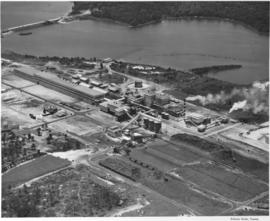
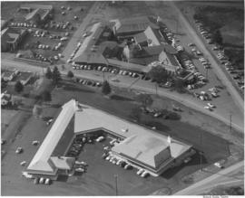
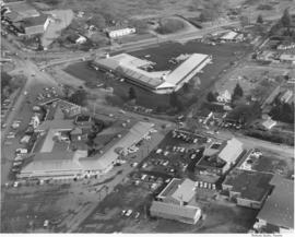
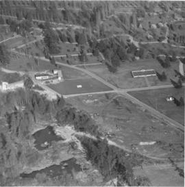
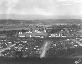
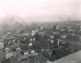
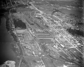
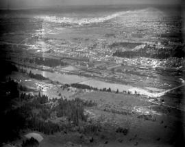
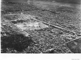
This aerial view of the Lakewood Center was taken in November of 1955 on behalf of the Lakewood Development Co., who operated the community center. Norton Clapp had originally built the Lakewood Community Center in 1937 as one of the nation's first one-stop shopping centers. Clapp, known as the founder of Lakewood, nurtured the idea of a growing suburban community and realized that it would need additional businesses and services to help it grow. The Lakewood Center underwent several expansions in the 1950's. In November, 1955, it reopened to celebrate a new addition, the modernized Colonial in an open triangle shape on the east side of the center. One 285-ft. leg faced Gravelly Lake Dr., the other 235-ft leg faced Mt. Tacoma Dr. with the "open" side to Bridgeport Way. Fourteen new businesses, including Sprouse-Reitz variety store, Lakes Realty, Andrews Women's Apparel, Lou Johnson, Selden's, Tacoma Savings and Loan, and Lakewood Record and Book Shop, took occupancy in the new building. (TNT 11-16-55, C-14)


Aerial photographs; Lakewood Community Center (Lakewood); Shopping centers--Lakewood--1950-1960; Lakewood Development Co. (Lakewood);

A95795-6

Aerial photographs requested by Reichhold Chemicals, Inc., were taken on January 12, 1956. The company had purchased 51.2 acres of land from the Port of Tacoma for $204,920. They would be constructing a large plant on acreage south of Lincoln Avenue between the Tacoma Sash & Door and Pennsalt. Reichhold hoped to begin operations in April, 1956. The protein adhesive and pentachorohenol plant would first employ 50 people. Aerial view of land shows sides of the building going up; there is no roof or flooring. Makeshift dirt roads have been created so that construction workers' vehicles and heavy equipment can reach the plant site. (TNT 12-25-55, B-4)


Aerial photographs; Building construction; Reichhold Chemicals, Inc. (Tacoma);

A98409-1A

ca. 1956. Mountain View Memorial Park in Lakewood. An aerial view of the cemetary. This is the left hand side of a large print of a single negative. For the right hand side see A98409 image 1b. Curved roads wind through the grounds providing access to the many grave sites. The war memorial can be seen right, just below center. Other structures located in the park include the funeral home, crematory, mausoleum, chapel and columbarium.


Cemeteries--Lakewood; Mountain View Memorial Park (Lakewood); Aerial views; Aerial photographs;

BOLAND-B12169

Aerial view of City Center. Although taken in March of 1925, this view of Tacoma's City Center still shows the contrast between its office buildings and other edifices and the (then) relatively undeveloped industrial Tideflats across the waterway. The Pierce County Courthouse with its 230-foot tower can be seen in the distance; closer near the foreground are the Puget Sound National Bank Bldg. with its familiar spire, the nearly completed Washington Building, the smaller Rust Building, and nearest to the 11th St. Bridge (now Murray Morgan Bridge), the Tacoma Building. TPL-1778; G8.1-027A


Aerial views; Aerial photographs; Cityscapes; Office buildings--Tacoma--1920-1930; Pierce County Courthouse (Tacoma); Puget Sound National Bank (Tacoma);

BOLAND-B12170

View looking toward the City Center from the Wheeler Osgood plant in March of 1925. Dark smoke blots the spring skies and a few boats float placidly along the City Waterway. There is not much visible traffic on the nearby 11th St. Bridge (now Murray Morgan Bridge.) A similar view is Boland B12169. TPL-1346; G8.1-027B


Aerial views; Aerial photographs; Cityscapes; 11th Street Bridge (Tacoma);

BOLAND-B14964

Aerial view of Tacoma's east side and Cushman Hospital. The hospital for veterans is the cluster of buildings in the center of this June, 1926, photograph. Surrounding homes are nestled in wooded lots.


Aerial views; Aerial photographs; Cushman Hospital (Tacoma); Hospitals--Tacoma--1920-1930; Neighborhoods--Tacoma--1920-1930;

BOLAND-B15239

View by air in July of 1926 of the 146th Field Artillery camp at Camp Lewis. G69.1-137


Aerial views; Aerial photographs; Camp Lewis (Wash.);

BOLAND-B22650

Aerial view of 146th F.A. tents on June 26, 1930. The 146th Field Artillery were participating in the 1930 encampment at Camp Murray. The two-week encampment of the Washington National Guard would last until June 28th. 2600 officers and men, including some 400 Tacomans, would participate in these annual summer maneuvers. Lake in background is American Lake. G77.1-040 (TNT 6-13-30, p. 1-article on encampment)


Aerial photographs; Aerial views; Washington National Guard, 148th F.A. (Tacoma); American Lake (Wash.);

BOLAND-B22651

View by air of the 161st Infantry tents at Camp Dent on the grounds of Camp Murray. Camp Dent was the name of the 1930 encampment of the Washington National Guard. Thick stands of trees block the view of American Lake. G69.1-138 TPL-10319


Aerial views; Aerial photographs; Washington National Guard, 161st Infantry (Wash.); American Lake (Wash.);

BOLAND-B2314

This is how downtown Tacoma and surrounding areas appeared in the fall of 1919. In the foreground are houses and apartments west of Pacific Avenue. A few Tacoma landmarks are clearly visible in the distance: the Puget Sound National Bank building with spire and close to the 11th St. Bridge (now Murray Morgan Bridge), the Tacoma Building and the Perkins Building. Smoke billows from the various industrial plants and lumber mills in the Tideflats across the City (now Thea Foss) Waterway. G8.1-026;


Aerial views; Aerial photographs; Cityscapes; Puget Sound National Bank (Tacoma); Tacoma Building (Tacoma); Perkins Building (Tacoma); 11th Street Bridge (Tacoma);

BOLAND-B23717

Aerial view looking toward Tacoma's City Center. This May, 1931, view shows many prominent Tacoma landmarks including the Tacoma Building and Perkins Building flanking the 11th Street Bridge (now Murray Morgan Bridge); the newly completed 17-story Medical Arts Building (at center-right); the towering Washington Building at center; Puget Sound National Bank with spire (center-left) and the Pierce County Courthouse with tower in the far left background. TPL-1347; G8.1-021


Cityscapes; Aerial photographs; Aerial views; 11th Street Bridge (Tacoma); Tacoma Building (Tacoma); Medical Arts Building (Tacoma); Washington Building (Tacoma); Puget Sound National Bank (Tacoma); Pierce County Courthouse (Tacoma);

BOLAND-B23720

This May, 1931, aerial view of Tacoma's City Center was taken from the industrial Tideflats. The 11th Street Bridge (now Murray Morgan Bridge) is on the right. Jutting into the skyline are (l-r) the Pierce County Courthouse, Puget Sound National Bank, Washington Building, Tacoma Building, and the Art-Deco styled 17-story newly completed Medical Arts Building in the right background. TPL-1788; G91.012


Cityscapes; Aerial views; Aerial photographs; 11th Street Bridge (Tacoma); Pierce County Courthouse (Tacoma); Puget Sound National Bank (Tacoma); Washington Building (Tacoma); Tacoma Building (Tacoma); Medical Arts Building (Tacoma);

BOWEN BGN-176

Aerial view taken in February of 1926 of the Northern Pacific shops in South Tacoma. Known as the "South Tacoma Shops," the plant was composed of 36 separate brick buildings, covering 15 acres. Craftsmen from 20 expert fields were employed to build, rebuild and service anything that travelled on wheels for Northern Pacific west of the Mississippi. The plant operated from 1890 until its closure in 1974. The body of water to the left was a wetlands area commonly called the "South Tacoma Swamp." It has since been filled in. (TNT 2/18/1927, pg. 2)

BOWEN BGN-177

This print from a damaged glass plate negative shows an aerial view of South Tacoma taken in February of 1927. The massive South Tacoma Shops, owned by the Northern Pacific Railway, are located in the center. The plant repaired all Northern Pacific railroad locomotives and cars west of the Mississippi. The shops were composed of 36 separate brick buildings spread out over 15 acres. The grounds were over 1 1/2 miles long, and the work force of 1,250 employees from 20 expert crafts commanded a payroll of $1,500,000 per year. Established in 1890 as Edison Car Shops, the shops closed in 1974. The body of water in the foreground just west of the "shops" was a wetlands area affectionately known to residents of the area as the "South Tacoma Swamp." The road at the right, near the south end of the swamp, is 56th Street. (TNT 02/18/1927, pg. 2)

BOWEN TPL-016

ca. 1928. Elevated view of 1300 block of Pacific Avenue circa 1928. Among the many businesses on Pacific Avenue were the Owl Cafe at 1336 Pacific (lower left) and the Dillion Bldg at 1330-32 Pacific. The familiar spire of the Puget Sound National Bank is to the far right. The Pierce County Courthouse looms in the distance at far left back with the big white walled Greenwich Coliseum (407 So. 13th St.) below. The Greenwich Coliseum had opened in 1927 and would become a premier athletic venue and ballroom.

BOWEN TPL-6247

ca. 1928. A Street at So. 11th St., looking north, in 1928. The Tacoma Building, at right center, was completed in 1911. The building was home to the Weyerhaeuser Timber Co. and the Tacoma Commercial Club. It is currently being restored. The Tacoma Hotel can be seen in the background, located where the Frank Russell Co. building stands today.

BOWEN TPL-672

ca. 1929. Head of Commencement Bay while Sullivan Service at 101 Puyallup Ave. (lower left) was under construction. This aerial view was taken circa 1929. Visible landmarks and streets included: the Union Station at upper left corner; Albers Bros. Milling Co. at upper center (large darker building) ; Northwest Woodenware Co. at center along waterway; Wheeler-Osgood Co.'s saw mill at right center. The Sullivan Service was being built at this time facing Puyallup Ave. at left. Puyallup Ave., which runs horizontally left to right, also had the Independent Paper Stock Co. kitty-corner from Sullivan's at 132 Puyallup Ave. The Washington Gas & Electric Co. was also on the same side of Puyallup Ave. as the Independent Paper Stock Co., at 212-216, and was the large building near right. The street at lower bottom running left to right is South 25th St. E. (photograph torn at left corner)

BOWEN TPL-7012

ca. 1941. Circa 1941 aerial view of the business district of Tacoma at night clearly showing the buildings on Pacific Ave. between 9th and 11th on the east side of the street. Buildings shown include: the Anderson building (1001-05 Pacific), the Bank of California (1011-1013 Pacific), and the Washington Building (1019 Pacific). There is a large neon sign for Mobil Gas on top of the Washington Building.

BOWEN TPL-7624

ca. 1935. This is an aerial view of South 43rd and "L" Sts. circa 1935. South "L" runs horizontally in front of the Engine House No. 8 (4301 South "L"). The fire station was built in 1909, replacing the original which had moved to 4102 South "M." Neighboring lots appear small with many trees. BU-2125

C112481-1

Copy of customer print. Aerial photographs of Seattle's Huntington Rubber Mills' facilities were taken in the spring of 1958. The smaller building in front may have been the office and the larger elongated buildings nestled close together, plant facilities. All three have semi-curved roofs. There were also two other buildings joined together to the left of the photograph. Photograph ordered by Huntington Rubber Mills.


Aerial photographs; Huntington Rubber Mills (Seattle);

C116284-1

ca. 1958. Copy of customer's print. An artist has placed his conceptualized drawing of the new regional shopping center, to be later called the Tacoma Mall, along with the future I-5 freeway over an aerial photograph of the South 38th St. area. Steele Street would lead into the shopping center from South 38th St. The Lincoln Heights housing development are the winding roads just off 38th St. The heavily wooded area near the Mall is presumably the Tacoma Cemetery and South Park. Allied Owners, Inc., had applied four times by August, 1958, for rezoning from a residential to regional shopping center district. They wanted to build a $20 million South Tacoma shopping headquarters, "Town Center," in an area surrounding South 43rd, South 48th & Pine Sts. and the freeway. Each time their request before the City Planning Commission had been denied. Photograph ordered by Allied Owners, Inc. (TNT 8-31-58, A-6)


Aerial photographs; Architectural drawings;

C125600-1

ca. 1960. Customer copy of Tideflats area in 1960. This aerial photograph shows the various waterways and busy industrial scene of the Tideflats. In the foreground is the City (Thea Foss) Waterway. TPL-10130


Aerial photographs; Harbors--Tacoma; City Waterway (Tacoma);

Results 151 to 180 of 824