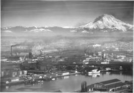
Aerial Photography

Taxonomy

Code

Scope note(s)

Source note(s)

Display note(s)

Hierarchical terms

Aerial Photography

Equivalent terms

Aerial Photography

Associated terms

Aerial Photography

824 Collections results for Aerial Photography

824 results directly related Exclude narrower terms

A49811-2

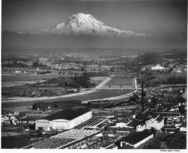
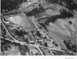
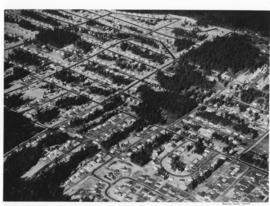
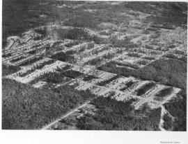
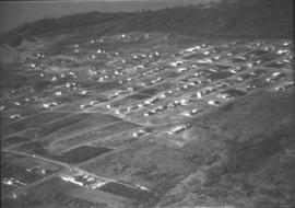
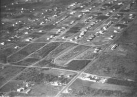
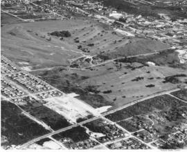
Aerial view of Allenmore Golf Course. The club house is seen in the middle of the large, newly landscaped golf course. The fairways are seen switch back style through the foreground and far background. New housing sub-divisions are seen across So. 19th Street.


Allenmore Golf Club (Tacoma); Golf--Tacoma--1950-1960; Sports & recreation facilities--Tacoma; Aerial photographs; Land use--Tacoma;

A50135-3

Scenic view of Mount Rainier beyond the Tacoma tideflats. City Waterway (later renamed Foss Waterway) lies in the foreground with Centennial Flouring Mills on the lower side of it and Uion Oil with their "76" storage tanks, Shell Oil, Northwest Door Company, and Richfield Oil lining the opposite side. The Puyallup River zig-zags into the distance beyond the smokestacks of St. Paul & Tacoma Lumber Company. This photograph was taken using an aerial camera. TPL-9862


Aerial photographs; Rainier, Mount (Wash.); Storage tanks--Tacoma; Tacoma Tideflats (Tacoma); Industrial facilities--Tacoma--1940-1950; Waterfronts--Tacoma;

D50606-2

An aerial view of the Feltrok Insulation Manufacturing Company taken at 7 p.m. June 9, 1950. The company was located on the Tacoma tideflats. Pennsylvania Salt Manufacturing Company is seen on the right. Feltrok was purchased by the American Rock Wool Corporation in 1952. About 35 persons were employed in the Tacoma operation at that time. (Tacoma Reporter, 7/21/1952, p.3)


Aerial photographs; Feltrok Insulation Manufacturing Co. (Tacoma); Industrial facilities--Tacoma--1950-1960; Pennsylvania Salt Manufacturing Co. of Washington (Tacoma);

D50612-1

An aerial view of St. Paul and Tacoma Lumber Company. Colonel Chauncey Griggs, Addison Foster, Henry Hewitt, Jr. and Charles Hebard Jones purchased 83,000 acres of timber in 1888 from the Northern Pacific Raillroad company in the largest purchase of timberland in the nineteenth century. Then they built a giant sawmill on "The Boot", a low island off the main tideflats, bordered by branches of the Puyallup River and Commencement Bay. They built the first standard-guage logging railroad and introduced the band-saw to Pacific Northwest lumber operations. They built the St. Paul & Tacoma Lumber Company. (The Mill on the Boot, Murray Morgan)


Aerial photographs; Lumber industry--Tacoma--1950-1960; St. Paul & Tacoma Lumber Co. (Tacoma);

C50632-1

Copy of aerial view of West Coast Grocery Company with Mount Rainier in the background. West Coast Grocery was an outlet for national and local brand foods to be shipped throughout the Pacific Northwest, Hawaii and Alaska. The company had served Tacoma and Alaska since 1887. Their brand name, Amocat (Tacoma spelled backwards), was a guide to shoppers to quality food products. Ordered by West Coast Grocery, Chet Chumington. (TNT, 2/13/1951, p.C-2)


Aerial photographs; Commercial facilities--Tacoma; West Coast Grocery Co. (Tacoma); Business enterprises--Tacoma--1950-1960; Storehouses--Tacoma; Rainier, Mount (Wash.); Mountains;

A52678-1

This aerial view of part of the sprawling St. Paul & Tacoma Lumber Company complex with Mount Rainier in the background dates from September of 1950. St. Paul & Tacoma with its many buildings, smokestacks and burners was located in the southwest section of the Tacoma tideflats near the Puyallup River; their headquarters were at 1220 Saint Paul Avenue. The white bridge near the center of the image crossing the channelized Puyallup River is the Lincoln Avenue bridge. Two railroad bridges and the Pacific Highway (U.S. Hwy 99) bridge can be seen further up the river.


Aerial photographs; St. Paul & Tacoma Lumber Co. (Tacoma); Cityscapes; Lumber industry--Tacoma--1950-1960;

A53023-1

Aerial view shows progress being made on new construction for the St. Regis Paper Company in September, 1950. Established as a company in 1899, St. Regis was open for business in Tacoma in 1928. Rebuilt and modernized in 1936, St. Regis bought additional acreage from the St. Paul Tacoma Lumber Company in 1947 to add a paper mill and multi wall bag plant. According to the St. Regis 1950 annual report, Tacoma's expansion of their pulp mill would enlarge the pulp capacity from 115,000 to 135,000 tons a year. The new capacity will be in production in 1951.


St. Regis Paper Co. (Tacoma)--1950-1960; Paper industry--Tacoma--1950-1960; Factories--Tacoma--1950-1960; Progress photographs--1950-1960; Aerial photographs;

A53024-1

Aerial view, 1000 foot elevation, of Sumner manufacturing division of Fleischmann's Yeast taken in September, 1950. Photograph taken at 5 p.m.; evening shadows start to creep over the large plant. Fleischmann's Yeast was part of Standard Brands, Inc., and is still sold in grocery stores today. Photograph ordered by Standard Brands' New York City office.


Fleischmann's Yeast (Sumner); Standard Brands, Inc. (Sumner); Aerial photographs;

D53468-35

Scenic views from Eastern Washington. An aerial view of the housing area across the Columbia River from the utility facilities at Grand Coulee Dam. Mason City was built on one side of the river during the dam construction and Engineer's Town grew on the opposite side. This view shows the land forms above the river into the distance.


Columbia River (Wash.); Land; City & town life;

A53468-131

Scenic views from Eastern Washington. An aerial view of the town on the far side of the river and Grand Coulee Dam plant facilities in the foreground. A tower for delivering electric power from the plant is seen on the right as others climb the hill from below. Electrical energy generated at the power plant at 13,800 volts is stepped up to 230,000 volts for long distance transmission by groups of transformers. High tension lines from the transformers are carried on steel towers over the powerhouse and up the canyon walls to a switchyard, where facilities are provided for interconnecting generating units and transmission lines. (Grand Coulee from "Hell to Breakfast", Fred O. Jones)


Aerial photographs; Columbia River (Wash.); Utility poles; Hydroelectric power;

D53468-8

Scenic views from Eastern Washington. An aerial view of farm land, a sprawling building in the center, a plant in the upper right with what may be a Ralston Purina logo painted on a tower, and a small residential community in the upper left in one of the broad valleys of eastern Washington. A narrow river meanders through the foreground.


Land; Valleys--Washington; Rivers; Industrial facilities;

A58591-5

Ariel photograph ordered by Tacoma Powdered Metals at 1501 East Taylor Way, Les Toulouse. A railroad spur has been added along the side of the building with loading docks available. A sign on the building announces Purex-trend.


Aerial photographs; Industry--Tacoma--1950-1960; Railroad sidings--Tacoma; Chemical industry--Tacoma--1950-1960; Purex Corp. (Tacoma);

A58908-1

This aerial view of the St. Paul & Tacoma Lumber Company shows Mount Rainier in the background. Included in the photograph are the sawmill, lumber storage and shipping sheds, planing mill, dry kilns, and the barking and chipping plant. The log storage and sorting ponds, railroad log dumps, deep water shipping dock and shed are not shown, as the plant covers an area of 180 acres, about 1/4 mile wide and a mile long. The company sprawled along the St. Paul Waterway, to the left of this photograph, between St. Paul and Portland Avenues. The Puyallup River can be seen heading east with several bridges crossing it. Ordered by St. Paul & Tacoma Lumber Company. (Tree Life Hemlock, St. Paul & Tacoma Lumber Co.)


Aerial photographs; St. Paul & Tacoma Lumber Co. (Tacoma); Cityscapes; Lumber industry--Tacoma--1950-1960;

D58919-1

An aerial photograph of the Northgate shopping area. The building in the center of this June, 1951, photograph contains Larson's Department Store and Ridgecrest Super Market. Ordered by Phares Advertising. The area is mixed use with single-family residential areas near this commercial area.


Aerial photographs; Shopping centers--Seattle; Land use--Seattle--1950-1960; Real estate development--Seattle--1950-1960;

A59833-1

An aerial view of the new pre-fab plant of Bethlehem Pacific Coast Steel Corporation along a waterway at 8501 East Marginal Way, Seattle.The Seattle Fabricating Works of Bethlehem Pacific was the newest plant in the nation capable of fabricating steel for large buildings, bridges and towers. It was built in 1950 on 8 acres of land on East Marginal Way, across from Boeing Field. It normally had about 250 employees. In the plant, structural steel and plates are cut, punched, drilled, bent, machined and prepared for erection.


Bethlehem Pacific Coast Steel Corp. (Seattle); Aerial photographs; Factories--Seattle;

A60069-3

Aerial photographs of the Holroyd plant were taken in July, 1951. The Holroyd Company was located at 5047 South Washington; they specialized in making concrete masonry units but also manufactured different types of building materials. They also dealt with sand and gravel and steel windows, according to an entry in the 1951 City Directory. Large lake pictured may have been used for manufacturing purposes.


Aerial photographs; Holroyd Co. (Tacoma); Concrete products industry--Tacoma--1950-1960; Building materials industry--Tacoma--1950-1960; Concrete--Tacoma;

A60067-1

In July of 1951 a massive addition to the Lakewood Community Center at 6100 Motor Avenue S.W. in Lakewood was under construction. The original center, built by Norton Clapp, opened in July of 1937. With the addition, several new stores were added to the center including Selden's Lakewood. The Lakewood Community Center was one of the country's first one-stop shopping centers. Photograph commissioned by St. Paul & Tacoma Lumber Co. TPL-4412


Aerial photographs; Lakewood Community Center (Lakewood); Progress photographs; Shopping centers--Lakewood--1950-1960;

A60604-2

Aerial photographs of Mountlake Terrace were taken on August 16, 1951. Developers of this neighborhood near Seattle left many of the trees in the heavily forested area for homeowners to enjoy. Cul-de-sacs were starting to emerge as part of suburban lifestyles, to lessen amount of traffic on roads next to homes and provide safer play areas for children. Photograph commissioned by Budget Homes, Inc.


Aerial photographs; Housing developments--Mountlake Terrace;

A60604-6

Aerial photographs of Mountlake Terrace in August, 1951, show the growing development of the neighborhood near Seattle. Surrounded by heavily forested land, city streets are gradually being laid out and homes built. Developers managed to retain many of the trees while building the new homes. Photograph commissioned by Budget Homes, Inc.


Aerial photographs; Housing developments--Mountlake Terrace;

A60608-1

Aerial photograph of the scenic Columbia River was taken on August 17, 1951. Shadows are falling on the rocky tree-covered hills. There does not appear to be any river traffic at this particular moment in time.


Aerial photographs; Columbia River (Wash.); Rivers--Washington (State);

D61250-1

Aerial view of sewage disposal plant. Progress photograph of the new sewage disposal plant on Cleveland Way was taken by air on October 3, 1951. Construction continues on the new plant near the Puyallup River under the direction of Hoagland-Findlay Engineering Company who had the low bid of nearly $1,400,000. The two large circular structures are digesting tanks where raw sewage would be digested and eventually turned into fertilizer. Rectangular building appears to be a 14,000,000 gallon sedimentation tank. Photograph commissioned by Hoagland-Findlay. TPL-8824


Aerial photographs; Progress photographs; Building construction--Tacoma--1950-1960; Sewerage--Tacoma; Waste disposal facilities--Tacoma; Hoagland-Findlay Engineering Co. (Seattle);

D61250-2

Aerial photograph of sewage disposal plant. Progress was being made in the construction of a new waste disposal facility on Cleveland Way near the Puyallup River in October, 1951. Aerial view of plant; large circular structures are digesting tanks, square building between them the digestion control building. Raw sludge would be processed in the digesting tanks where ultimately it would be filtered, peeled off in cakes, and then hauled away for fertilizer. According to a 12/12/51 article in the News Tribune, the plant was designed to handle 27 million gallons of sewage a day. Photograph commissioned by Hoagland-Findlay. TPL-8825


Aerial photographs; Progress photographs; Building construction--Tacoma--1950-1960; Sewerage--Tacoma; Waste disposal facilities--Tacoma; Hoagland-Findlay Engineering Co. (Seattle);

D61250-3

Aerial view of sewage disposal plant. Hoagland and Findlay. Sewage treatment plan under construction. Wide canal on left.

A62426-2

Aerial photographs were taken of Jefferson Avenue in November, 1951. Building on the right hand corner belongs to Blake, Moffitt & Towne, wholesale distributors of printing and wrapping paper. Rectangular two-story buildings in center of photograph are probably structure known as "Jefferson House", built originally in 1945 to provide emergency accomodations for single men. Jefferson Avenue was primarily a business district, filled with apartment buildings and manufacturers. Photograph ordered by John Huston.


Aerial photographs; Cityscapes; Commercial streets--Tacoma--1950-1960;

A62921-1

An aerial view of the Fibreboard Plant in Sumner. The corrugated box plant had operated in Sumner since 1920. The plant was sold to Louisiana-Pacific Corp. in 1978 who planned to sell the division to a company that was in the container business. Ordered by Moulin Studio. (TNT, 10/10/1978)


Aerial photographs; Fibreboard Corp. (Sumner); Paper industry--Sumner;

A63168-1

An aerial view of the Narrowmoor Addition, a subdivision west of Jackson Avenue. Ordered by Burton W. Lyon, Jr., Puget Sound Bank Building.


Aerial photographs; Housing developments--Tacoma; Land subdivision--Tacoma; Land use--Tacoma; Real estate development--Tacoma;

A63168-2

An aerial view of the Narrowmoor Addition, a subdivision west of Jackson Avenue. Ordered by Burton W. Lyon, Jr., Puget Sound Bank Building.


Aerial photographs; Housing developments--Tacoma; Land subdivision--Tacoma; Land use--Tacoma; Real estate development--Tacoma;

A63168-4

An aerial view of the Narrowmoor Addition, a subdivision west of Jackson Avenue between Sixth and 19th Avenues. The Narrows portion of Puget Sound is below, to the west. The ferry dock at the base of Sixth Avenue can be seen on the left. Ordered by Burton W. Lyon, Jr., Puget Sound Bank Building.


Aerial photographs; Housing developments--Tacoma; Land subdivision--Tacoma; Land use--Tacoma; Real estate development--Tacoma;

A63231-1

Aerial photograph to show the steel work on a new building at St. Regis, Tacoma. Construction of a bag plant at the St. Regis Paper company started in June 1951 with the driving of piling as the first step. The addition was built of steel and concrete and would be used for the production of industrial-use bags for cement, fertilizer and other materials needing heavy-duty holders. When completed, this plant would replace the leased plant at Seattle. (TNT 6/15/1951; St. Regis Paper Company 1951 Annual Report)


St. Regis Paper Co. (Tacoma)--1950-1960; Progress photographs; Building construction--Tacoma--1940-1950; Aerial photographs; Paper industry--Tacoma--1950-1960;

A63233-1

16 new elevators have been added to the existing elevators at the Port of Tacoma. The project added 500,000 bushels to the Port's capacity. Baby flattops (smaller aircraft carriers) are seen across the Port Industrial Waterway. The grain elevators had a 2 million bushel capacity by 1954. They could receive up to 100 cars per day, with 3 receiving legs. Two shipping legs provided shop delivery at a maximum rate of 30,000 bushels per hour. Rail facilities provided for 50 cars to be at the unloading track. There was also a 50 ton hydraulic automatic grain truck dumper. The first pier behind the elevators was Pier 1 and the next one (with a docked ship) was Pier 2. The Port Industrial Waterway was renamed the Blair Waterway in 1970, in honor of past Port of Tacoma Commissioner A.E. Blair. (Tacoma brochure: "Port of Tacoma...Invitation to Industry") (pier identification provided by a reader)


Aerial photographs; Port of Tacoma (Tacoma)--1950-1960; Grain elevators--Tacoma--1950-1960; Aircraft carriers--Tacoma--1940-1950; Harbors--Tacoma; Marine terminals--Tacoma--1940-1950; Shipping--Tacoma--1940-1950;

Results 151 to 180 of 824