Aerial Photography

Taxonomy

Code

Scope note(s)

Source note(s)

Display note(s)

Hierarchical terms

Aerial Photography

Equivalent terms

Aerial Photography

Associated terms

Aerial Photography

824 Collections results for Aerial Photography

824 results directly related Exclude narrower terms

D67903-4

ca. 1952. Aerial photograph of residential area, most probably Mountlake Terrace, circa 1952. Mountlake Terrace was an expanding area north of Seattle, in Snohomish County, just north of the King county line. The largely residential area served as a bedroom community for Seattle workers. The area surrounding is still heavily forested and undeveloped. The streets are laid out in curves, forming cul de sacs.


Aerial photographs; Housing developments--Mountlake Terrace;

D67903-9

ca. 1952. Aerial view of Northern King County, north of Seattle and west of Lake Washington. The large building on the left with the marquee is most probably the Crest Movie Cinema, located at 16505 5th Ave. NE, Seattle. The homes here appear to mid sized and are located on large lots. The streets are laid out on a square block formation. There are still large sections of woods in view.


Aerial photographs; Aerial views; Housing developments--Seattle; Neighborhoods--Seatte;

D67903-2

ca. 1952. Aerial photograph of residential area, most probably Mountlake Terrace. Mountlake Terrace was an expanding area north of Seattle, in Snohomish County, just north of the King county line. The largely residential area served as a bedroom community for Seattle workers. The area surrounding is still heavily forested and undeveloped. The streets are laid out in curves, forming cul de sacs.


Aerial photographs; Housing developments--Mountlake Terrace;

A63895-1

An aerial view of the plant facility for Hooker Electrochemical Company located at 605 Alexander Avenue on the Tacoma tideflats. The Hylebos Waterway provided excellent accessibility with a company dock and a railroad spur running through the facility enhanced transportation even further. The Port of Tacoma sold an additional 20-acre site to Hooker Electrochemical in December 1951 for $56,400 according to George Osgood, manager of the Port. The property, including a 1,200-foot frontage on the Port-Industrial waterway, was to be used for further expansion of the chemical firm's Tacoma plant. (TNT, 12/16/1951, p.1)


Aerial photographs; Hooker Electrochemical Co. (Tacoma); Logs; Hylebos Waterway (Tacoma); Harbors--Tacoma; Factories--Tacoma--1940-1950; Chemical industry--Tacoma--1950-1960;

A64784-1

An aerial view of the new multiwall bag plant at St. Regis. The plant was completely equipped to produce a full range of multiwall bags. Equipment included six production lines, three printing presses, a complete art and engraving department and auxiliary equipment. This plant replaced a leased plant in Seattle. (TNT, 10/19/1952)


St. Regis Paper Co. (Tacoma)--1950-1960; Aerial photographs; Mills--Tacoma--1950-1960; Paper industry--Tacoma--1950-1960;

A64784-2

An aerial view on February 16, 1952, showing the new multiwall bag plant at St. Regis. St. Regis also had other bag plants on the Pacific Coast at Los Angeles and San Leandro, California. The company also maintained complete engineering and service facilities for automatic bag filling equipment, including a machine shop at Los Angeles, and packer sales and engineering offices at San Francisco and Seattle. The company was self-contained on the west coast. (TNT, 10/19/1952)


St. Regis Paper Co. (Tacoma)--1950-1960; Aerial photographs; Mills--Tacoma--1950-1960; Paper industry--Tacoma--1950-1960;

A64784-3

An aerial view of the new multiwall bag plant at St. Regis. The expansion of the bag plant facilities by St. Regis reflected the continuing trend of industry and agriculture to use the multiwall shipping sack. It was estimated that approximately 2 1/2 billion multiwall bags were used in 1951 for all types of products, compared with less than half a billion in 1938. The multiwall bag came into general use as an industrial container in the mid 1920's and was used for packaging cement and other rock products. Shortly thereafter is was adopted by the sugar industry. (TNT, 10/19/1952)


St. Regis Paper Co. (Tacoma)--1950-1960; Aerial photographs; Mills--Tacoma--1950-1960; Paper industry--Tacoma--1950-1960;

A66035-40

Aerial view of 1952 Daffodil Parade as it proceeds down Pacific Avenue. The day of the parade dawned clear and sunny, prompting 200,000 Tacomans to line the parade route. People stood 10 deep at prime viewing spots, with others watching from windows, awnings, hanging from fire escapes and perching on roofs.


Celebrations--Tacoma; Festivals--Tacoma; Parades & Processions--Tacoma--1950-1960; Puyallup Valley Daffodil Festival (1952 : Tacoma); Drill teams; Marching bands; Floats (parades)--Tacoma--1950-1960; Aerial photographs;

A66035-36

Aerial view of 1952 Daffodil Parade as it proceeds down Pacific Avenue. The 15 mile long parade wound its way down Pacific Ave. from 9th to 19th. A Marine Corps color guard led the parade, followed by the float bearing Queen Eva Beattie and her princesses, royally escorted by the Rosarians of Portland, Oregon. Following the City Light float bearing the Queen were 70 floats and decorated cars, 21 bands, 28 marching units and three mounted groups. (TNT 4-6-1952, pg. 1)


Celebrations--Tacoma; Festivals--Tacoma; Parades & Processions--Tacoma--1950-1960; Puyallup Valley Daffodil Festival (1952 : Tacoma); Drill teams; Marching bands; Floats (parades)--Tacoma--1950-1960; Aerial photographs;

A68175-A

An aerial view of Philadelphia Quartz' plant on the Tacoma tideflats. Belgian silica sand and California soda ash were chemically combined to provide a product sold largely in Tacoma but marketed also in other Northwest cities. Silicate of soda, water-glass to farm households, was used in adhesives for the plywood industry and corrugated paper-board for the container industry.


Chemical industry--Tacoma--1950-1960; Minerals; Philadelphia Quartz Co. of California (Tacoma); Aerial photographs;

A71928-1

Aerial views of Rainier State School in Buckley were taken in late December, 1952, at a height of 800-1000 feet. Rainier School had experienced severe overcrowding in the late 1940's and was forced to request nearly $6,500,000 in aid from state and federal sources to alleviate the housing crunch. Rainier School was only one of two specialized state schools in Washington State and had long waiting lists. It boarded physically and mentally handicapped children, and by the early 1950's, had an enrollment of nearly 2000.


Aerial photographs; Western State Custodial School (Buckley); Institutional care--Buckley; Children--Health & welfare

A71928-3

Mount Rainier looms over the sprawling campus of the Rainier State School in Buckley in December of1952. This aerial photograph, taken at a height of 800-1000 feet, shows the large institution and the rural landscape that surrounded it. The Rainier School, which housed mentally and physically handicapped children, experienced severe overcrowding during the late 1940's to early 1950's.


Aerial photographs; Western State Custodial School (Buckley); Institutional care--Buckley; Children--Health & welfare; Rainier, Mount (Wash.);

A74601-4

ca. 1953. Aerial photographs, St. Regis Paper Co. St. Regis had plants in several states, as well as in Canada and South America. This aerial view of the St. Regis plant in Jacksonville, Florida, was taken in 1953. As was the case in most of the company's plants, there was plenty of room for future expansion and water transportation was readily available.


Aerial photographs; St. Regis Paper Co. (Jacksonville, Fl.)--1950-1960; Paper industry--Jacksonville--1950-1960; Industrial facilities--Jacksonville--1950-1960;

A72491-1

ca. 1953. An undated aerial photograph of the industrial Tacoma Tideflats area shows a majestic view of snow-capped Mount Rainier looming in the background. Shaffer Terminals are on the right hand side of City Waterway; the waterway is now known as the Thea Foss Waterway. Shell Oil facilities are probably across from Shaffer's.


Aerial photographs; Rainier, Mount (Wash.); Waterfronts;

WO76034-A

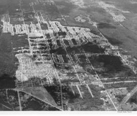
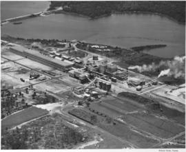
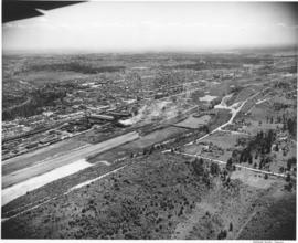
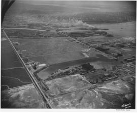
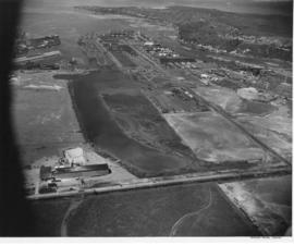
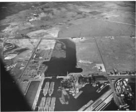
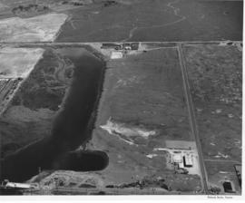
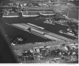
ca. 1953. This aerial view of the northeast section of the Tacoma tideflats from 1953 shows part of the Port of Tacoma, lower left, and the 185-acre Port Industrial Yard which was acquired by the Port in 1959. Five mothballed WWII baby flattops are moored in the Port Industrial Waterway. The incomplete Port Industrial Waterway bridge, later named the Blair Bridge, can be seen at the right. The bridge opened for traffic on November 14, 1953. The bridge is 712 feet long with a 40 foot roadway and 5 feet of sidewalk on one side only. It has a clearance at high tide of 12 feet. There is a 150 foot channel between the main piers for the passage of shipping vessels. The two main channel piers are 45 x 55 foot and house the operating machinery, counterweights and electrical equipment for opening and closing the span drawbridge. They are the equivalent in height, measured both above & below the water, to a seven story building. The cost of the bridge was $1,600,000. (TNT 11/13/1953, special section #D)


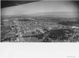
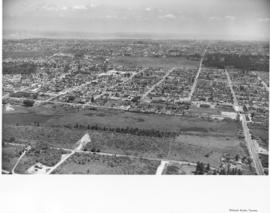
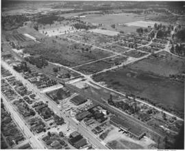
Aerial photographs; Port of Tacoma (Tacoma)--1950-1960; Aircraft carriers--Tacoma--1950-1960; Harbors--Tacoma; Aerial views; Blair Bridge (Tacoma); Port Industrial Waterway Bridge (Tacoma); Vertical lift bridges;

D74875-2

Aerial photograph of Sixth Avenue. This aerial photograph of Sixth Avenue near Union shows how the nearby streets are neatly partitioned into grids with well-kept homes and businesses. Near the center of the photograph is the new Tradewell supermarket #30 with its large tower jutting into the sky and expansive parking lot. On the next block a portion of the new Sixth & Washington Square Building can be seen. Photograph ordered by Carl Swanson, Tradewell Stores, Inc.


Aerial photographs; Tradewell Stores, Inc. (Tacoma); Sixth & Washington Square Building (Tacoma);

D75872-77

Aerial photographs. The wing of an airplane is visible as aerial photographs were taken of the South Tacoma and possibly other local areas on June 15, 1953. The photo appears to be looking north toward Vashon Island. There is a gravel pit to the right. There were still large areas of undeveloped and wooded land at this time in Tacoma's history. Photograph ordered by North Pacific Bank.


Aerial photographs; Neighborhoods--Tacoma--1950-1960;

D75872-70

Aerial photographs. Photographs taken from an airplane in June, 1953, show the South Tacoma area as it was back then. Rows of homes and businesses are interspersed with stretches of unoccupied, wooded land. Surprisingly, there is little or no traffic on South 56th St., believed to be on the extreme right, quite unlike today. Photograph ordered by North Pacific Bank.


Aerial photographs; Neighborhoods--Tacoma--1950-1960;

D75872-79

Aerial photographs. A large number of photographs of the South Tacoma area were taken in one day by airplane on behalf of North Pacific Bank, which was based in that area. Multi-lane road is possibly South Tacoma Way with People's Warehouse on the right and possibly Vaughan Lumber towards the center. S 66th St. intersects towards the center of the photo with South Tacoma Way; Mount Tahoma High School would later be built on the undeveloped land nearby.


Aerial photographs; Neighborhoods--Tacoma--1950-1960;

D75872-59

Aerial photographs. The South Tacoma area in the early 1950's was still vastly undeveloped. Aerial photographs shot on behalf of North Pacific Bank, based in South Tacoma, show large stretches of unoccupied land which remained heavily wooded. The Northern Pacific Railway shops can be seen about the middle of the picture on South 51st & Adams with the South Tacoma Air Park and Tyler Street nearby. TPL-2058


Aerial photographs; Neighborhoods--Tacoma--1950-1960; Northern Pacific Railway Co. (Tacoma);

D75872-24

Aerial photographs. Several aerial photographs of the South Tacoma area were taken on behalf of North Pacific Bank in mid-June, 1953. This photo shows South Tacoma Way looking southward; even then, traffic was heavy on this major roadway. Businesses and homes dot the landscape with a noticeable amount of trees and foliage remaining. Old Tacoma Cemetary is believed to be on the left side of the photograph. TPL-6471


Aerial photographs; Neighborhoods--Tacoma--1950-1960;

D75943-14

Aerial view of the Tacoma tideflats and Port of Tacoma. Lincoln Ave. runs up the left hand side of the picture and East 11th Street with its partially completed bridge on the right. The smaller body of water in the foreground is the Port Industrial Waterway, the one in the back is Hylebos Waterway and the large body of water on the right is Commencement Bay. The stored baby flattops and the Port of Tacoma can be seen on the right by the bridge. The vacant area is 1500 acres of vacant industrial land that the city hoped would turn Tacoma into the industrial center of the West.


Aerial views; Port of Tacoma (Tacoma)--1950-1960;

D75943-6

This aerial view of the Tacoma tideflats and Port of Tacoma was taken in July of 1953. At the upper right of center a small fleet of baby flat tops built in Tacoma during World War II are "mothballed" in the Wapato (now Blair) Waterway next to the Tacoma naval station. The Port of Tacoma is to the left of the mothballed ships. Browns Point can be seen in the upper right corner. Commencement Bay can be seen lying beyond the Port. The two streets crossing the tideftats are East Eleventh Street and Lincoln Avenue (in the bottom half of the image). TPL-2259.


Aerial views; Port of Tacoma (Tacoma)--1950-1960;

D75943-8

Aerial view of the Tacoma tideflats and Port of Tacoma. TPL-2254. The intersection of Lincoln Ave. (right), Alexander and E. 11th Street (left). Port of Tacoma and Port Industrial Waterway visible. Photograph shows the 1500 acres of vacant land that the city of Tacoma hoped to sell to industries needing a deep water port.


Aerial views; Port of Tacoma (Tacoma)--1950-1960;

D75943-12

Aerial view of the Tacoma tideflats and Port of Tacoma. TPL-2251 Lincoln Ave. runs across the front of the photograph, with the Stauffer Chemical plant shown. The body of water in the center of the picture is the Port Industrial Waterway. East 11th Street runs between the waterway and Commencement Bay. The partially completed Port Industrial Waterway bridge can be seen, also the mothballed WWII baby flattops and the Port of Tacoma with its piers 1 & 2. The land curves around the right side of the picture ending in Browns Point.


Aerial views; Port of Tacoma (Tacoma)--1950-1960;

D75943-16

Aerial view of the Tacoma tideflats and Port of Tacoma. High tide. The road about halfway up the picture is East 11th Street as it crosses the Port Industrial Waterway. The partially completed bridge that opened in November of 1953 can be seen. In the left foreground of the picture are the baby flattops constructed for WWII and then stored here after the war. The Port of Tacoma Pier 1 lies to the right. Port of Tacoma Rd. runs from the Port to Lincoln Ave. The city of Tacoma had plans for all of the vacant land. They planned to fill it where needed and sell it to industries that needed deep water ports. TPL-2257


Aerial views; Port of Tacoma (Tacoma)--1950-1960;

D75943-22

Aerial view of the Tacoma tideflats and Port of Tacoma. High tide. Prominent in the picture is the St. Paul and Tacoma Lumber Co. lying to the right of E. 11th Street in the foreground of the picture. Commencement Bay is to the left of 11th St., to the right is almost 1500 acres of vacant industrial land that Tacoma hoped to develop. The Port Industrial Waterway can be seen to the left rear of the picture. The city wanted to dredge this body of water for a deep water channel and collect premium prices for the vacant 1 1/2 miles of land lying beside it.


Aerial views; Port of Tacoma (Tacoma)--1950-1960;

D75943-4

Aerial photographs of the Port of Tacoma at low tide. The body of water in the foreground of the picture with the log booms is the Puyallup Waterway. The following body of water is the Milwaukee Waterway. The road with the bridge is East 11th Street. Milwaukee Way runs at a right angle from 11th and crosses Lincoln Ave. The inland area beyond this point is mostly vacant with some scattered industries. Tacoma hoped to develop this 1500 acres into prime industrial area.


Aerial views; Port of Tacoma (Tacoma)--1950-1960;

D75943-2

Aerial photographs of the Port of Tacoma at low tide. The body of water is the Port Industrial Waterway, which was being promoted as a future deep water channel. The land lying to the right of the waterway was 1 1/2 miles of industrial land with deepwater access. The road in front of the waterway is East 11th Street, to the right is the Port of Tacoma Road and to the rear is Lincoln Ave. The area behind Lincoln Ave. was scheduled to be filled with the dirt dredged from the waterway and then sold to industries. Stauffer Chemical can be seen on Lincoln Ave. (2545 Lincoln Ave.) The partially completed Port Industrial Waterway bridge can be seen in the foreground of the picture.


Aerial views; Port of Tacoma (Tacoma)--1950-1960;

D75943-23

Baby flat tops built in Tacoma during World War II are "mothballed" along the Port of Tacoma waterfront following the war alongside the Naval Storage area. Hooker Electrochemical Co. lies behind the Naval area (see the circular tanks.) The Port of Tacoma is in the front of the picture with its "finger pier." The partially completed Port Industrial Waterway bridge can be seen on the right hand side next to the flattops. TPL-2253.


Aerial views; Port of Tacoma (Tacoma)--1950-1960;

Results 181 to 210 of 824