Aerial Photography

Taxonomy

Code

Scope note(s)

Source note(s)

Display note(s)

Hierarchical terms

Aerial Photography

Equivalent terms

Aerial Photography

Associated terms

Aerial Photography

824 Collections results for Aerial Photography

824 results directly related Exclude narrower terms

D11649-13

Aerial view of industrial section of Tacoma taken on July 20, 1941. The business district of downtown Tacoma is in the distance. Various log dumps dot the waterways in the foreground.


Aerial views; Aerial photographs; Cityscapes; Logs; Waterways;

D11649-15

Aerial view of industrial section of Tacoma as seen on July 20, 1941. Log booms in foreground.


Aerial views; Aerial photographs; Logs;

D11649-16

Aerial view in July of 1941 of industrial section of Tacoma from Commencement Bay looking eastward with focus on various waterways.


Aerial views; Aerial photographs; Waterways;

D11649-19

1941 Aerial view of Sea-Tac Shipyard with Peterman Manufacturing Company in foreground, looking west. The Peterman Co. manufactured fir doors and veneer panels. It was forced to vacate the property in June of the following year as the Shipyard needed space to build the many ships under contract.


Aerial views; Aerial photographs; Seattle-Tacoma Shipbuilding Corp. (Tacoma); Boat & ship industry--Tacoma--1940-1950; Peterman Manufacturing Co. (Tacoma);

D11649-2

Aerial view of downtown Tacoma including waterfront warehouses and half-moon railroad yards. This July of 1941 photograph, looking westward, shows the densely packed business districts of Tacoma as well as outlying residential areas. The waterway is the City (now Thea Foss) Waterway with the 11th St. Bridge (now Murray Morgan Bridge) in view.


Aerial views; Aerial photographs; Cityscapes; City Waterway (Tacoma); Business districts--Tacoma--1940-1950; Commercial streets--Tacoma--1940-1950;

D11649-22

Aerial view of Sea-Tac Shipyard taken on July 20, 1941. Even before the U.S. entered WWII, the Seattle-Tacoma Shipyard was busy with building tankers and C-3 freighters for the government.


Aerial views; Aerial photographs; Seattle-Tacoma Shipbuilding Corp. (Tacoma); Boat & ship industry--Tacoma--1940-1950;

D11649-6

1941 Aerial view of downtown Tacoma showing the Central Business District, Port/Industrial, and Central residential areas. The 11th St. Bridge (now Murray Morgan Bridge) leads traffic over the City (now Thea Foss) Waterway over to the industrial Tideflats.


Aerial views; Aerial photographs; Cityscapes; City Waterway (Tacoma); Business districts--Tacoma--1940-1950; Commercial streets--Tacoma--1940-1950; 11th Street Bridge (Tacoma);

D11649-8

Aerial view of downtown Tacoma showing Central Business District and Port/Industrial areas. This view, looking east toward the bustling industrial Tideflats, was taken on July 20, 1941.


Aerial views; Aerial photographs; Cityscapes; Business districts--Tacoma--1940-1950; Commercial streets--Tacoma--1940-1950;

D116584-10C

ca. 1958. Aerial view of newly built County-City Building, 930 Tacoma Avenue South, circa 1958, and surrounding neighborhood. The building would be dedicated in April of 1959. Directly behind its left wing is the venerable Pierce County Courthouse, 1012 South "G" St., soon to be demolished and ground transformed into parking for the County-City Building. At left lower corner is the Tacoma Public Library, 1102 Tacoma Avenue South.


Aerial views; Aerial photographs; County-City Building (Tacoma); Pierce County Courthouse (Tacoma); Tacoma Public Library (Tacoma); Streets--Tacoma--1950-1960; Commercial streets--Tacoma--1950-1960;

D116584-8C

ca. 1958. Aerial view of the neighborhood around Tacoma Avenue South near the new County-City Building circa 1958. In the center is the County-City Building, with its two wings and tower at 930 Tacoma Avenue South, built to replace the deteriorating Pierce County Courthouse immediately to its rear. The Romanesque old Courthouse at 1012 South "G" would be demolished and the area used as a parking lot. At left center is the Tacoma Public Library, 1102 Tacoma Avenue South. The Central School, 601 South 8th, is at right center edge but McDonald's is yet to be built next door on Tacoma Avenue South.


Aerial views; Aerial photographs; Cityscapes--Tacoma--1950-1960; County-City Building (Tacoma); Pierce County Courthouse (Tacoma); Tacoma Public Library (Tacoma); Central School (Tacoma); Streets--Tacoma--1950-1960;

D116584-9C

ca. 1958. This aerial view is looking west with focus upon the newly built County-City Building at 930 Tacoma Avenue South, circa 1958. The venerable Pierce County Courthouse, directly behind one of the County-City Building wings, was in poor shape and after much discussion, it was decided to build a new structure to replace it. Site preparation and excavation began in 1955 but the building would not be completed until 1959. Also in view are the Tacoma Public Library, directly across the street at 1102 Tacoma Avenue South, and the State Armory at 715 South 11th, behind the Pierce County Courthouse.


Aerial views; Aerial photographs; County-City Building (Tacoma); Pierce County Courthouse (Tacoma); Tacoma Public Library (Tacoma); State Armory (Tacoma); Commercial streets--Tacoma--1950-1960; Streets--Tacoma--1950-1960;

D11701-2

Aerial view of Ferro-Alloys plant on Tideflats. [Also dated 08-01-1941]


Aerial Photographs - Pierce County - Tacoma - Port IndustrialIndustries - Metal Industries

D11794-1

Aerial view of Northern Pacific Rail property at Lakeview which was taken on August 22, 1941. Land is dotted with trees in foreground with thicker forests toward the top of the photograph. Few, if any, homes in sight. Ordered by Raleigh -Hayward Company.


Aerial photographs; Neighborhoods--Lakewood; Land;

D11794-10

Aerial view of Northern Pacific property at Lakeview. Closer view of land seen in D11794, image 1. This time buildings can faintly be seen in this photograph taken on August 22, 1941. Part of series ordered by Raleigh-Hayward Company.


Aerial photographs; Land; Neighborhoods--Lakewood;

D11961-30

Sea-Tac Shipyard, aerial view of facilities. Docks, buildings, equipment and water as photographed in October of 1941.


Aerial photographs; Seattle-Tacoma Shipbuilding Corp. (Tacoma); World War, 1939-1945--Economic & industrial aspects--Tacoma; Boat & ship industry--Tacoma--1940-1950;

D12245-8

Aerial view of cleared property above The Narrows showing sparse development in the area east of subject site. Ordered by Mr. Wiborg.


Aerial photographs; Real estate development--Tacoma--1940-1950; Clearing of land--Tacoma--1940-1950; Land subdivision--Tacoma--1940-1950;

D125600-21

ca. 1960. Richards stock footage. Aerial photograph taken in 1960 of the Hooker Electrochemical Co. plant located at 605 Alexander Avenue on the Tacoma Tideflats. A ship is docked at the company dock on the Hylebos Waterway, ready to transport and transfer Hooker products. A railroad spur running through the facility also made transportation of Hooker chemicals an easier task.


Aerial photographs; Hooker Electrochemical Co. (Tacoma); Chemical industry--Tacoma--1960-1970; Hylebos Waterway (Tacoma); Harbors--Tacoma;

D128560-2

Aerial photograph of Bethlehem Steel plant. A Richards Studio photographer in a SeaTac Helicopter flew over the Bethlehem Steel nut and bolt plant on October 12, 1960 and took several shots of the facility located at Spokane & West Marginal Way in Seattle. The large plant appears nestled in a mixed residential/industrial neighborhood with easy access to highways and water transportation. Photograph ordered by Bethlehem Pacific Coast Steel Corp.


Aerial photographs; Bethlehem Pacific Coast Steel Corp. (Seattle); Industrial facilities--Seattle;

D129383-15

Large sections of wooded terrain are interspersed with neatly laid out streets in aerial photographs taken by the Richards Studio on December 15, 1960. Looking northwest, South Tacoma railroad shops are on the left; flat bare land upper center is location of future Tacoma Mall. Photograph taken on behalf of North Pacific Bank.


Aerial photographs; Neighborhoods--Tacoma--1960-1970;

D129737-2

This aerial view of Tacoma, taken from 1,200 feet, shows I-5 and the 38th Street cloverleaf as they appeared in January of 1961. The simple curve of the highway had not yet been complicated by the addition of the Highway 16 interchange. The houses to the left are surrounded on the north and west by I-5 and on the south by 38th Street. The buildings at the bottom, right are on South Tacoma Way.


Aerial photographs; Express highways--Tacoma--1960-1970;

D129752-1

Looking northward, the Lincoln district in 1961. Lincoln High School is group of buildings near the center of the photograph; street to its right is South G. South 38th St. runs horizontally near bottom. Large trees are part of Lincoln Park. Holy Rosary Church with tall steeple is less than a mile away from the school. Photograph ordered by Lincolnian, Lincoln High School's yearbook. TPL-9695


Aerial photographs; Lincoln High School (Tacoma); Public schools--Tacoma; Neighborhoods--Tacoma--1960-1970;

D129800-130

ca. 1961. Stock footage, 1961. Air view of the Tacoma Narrows Bridge in 1961; the second Narrows Bridge was eleven years old at that point. Much of the wooded area in the photograph has been replaced by homes 40 years later.


Aerial photographs; Tacoma Narrows Bridge (Tacoma); Suspension bridges--Tacoma; Bridges--Tacoma--1960-1970;

D129800-131

Aerial view from the Narrows of Tacoma's West End with downtown, the Tideflats and Browns Point beyond. Sixth Avenue runs down the right side of the photograph, veering left to form the entranceway for the second Narrows Bridge. Pearl Street crosses Sixth about 2/3 up, with the area allotted for the Tacoma airport still undeveloped. The area between where Sixth leads to the bridge and Titlow Beach (off the photo at right) is mostly undeveloped. The smokestack for the ASARCO plant can be seen on the far left, surrounded by the city of Ruston. For an older view of this same area (ca. 1939), see D8245 image 1. TPL-9158


Aerial photographs; Neighborhoods--Tacoma--1960-1970; Streets--Tacoma--1960-1970; Tacoma Narrows Bridge (Tacoma); Bridges--Tacoma--1960-1970; Suspension bridges--Tacoma;

D129800-186

ca. 1961. Circa 1961 aerial view of Tacoma Yacht Club, ASARCO smelter, Point Defiance Park and Ruston. The large, long buildings to center left belong to the copper smelter ASARCO. To the right of ASARCO is the Tacoma Yacht Club and its mooring. Above the Yacht Club is the outline of Pt. Defiance's amusement park Funland. To the upper right hand of the photograph is the pond garden in the Bowl area entrance to Point Defiance. To the upper center is the city of Ruston.


Aerial photographs; Boathouses; Boats; Tacoma Yacht Club (Tacoma); Mooring; American Smelting & Refining Co. (Tacoma); Smelters--Tacoma--1950-1960; Funland (Tacoma); Point Defiance Park (Tacoma); Amusement parks--Tacoma--1930-1940;

D129800-3

ca. 1961. Scenic views and stock file, 1961. Aerial view heading north toward the water showing site of Yakima Avenue Bridge under construction with Hood St. Reservoir as large body of water to the lower center. Holy Rosary Church is structure with tall steeple near Tacoma Avenue South. Downtown businesses at top center with busy industrial Tideflats across waterways at right.


Aerial photographs; Bridge construction--Tacoma--1960-1970; Bridges--Tacoma--1960-1970; Yakima Avenue Bridge (Tacoma); Holy Rosary Church (Tacoma);

D129800-33

ca. 1961. Scenic views and stock footage, 1961. The tip of Mount Rainier rises in the background in this aerial 1961 photograph of Tacoma's industrial areas, downtown, and north end landscape. The wooded area near downtown is Wright Park; waterway is the City (now Thea Foss) Waterway, and the noticeable arched street the location of the Tacoma Lawn Tennis Club.


Aerial photographs; Rainier, Mount (Wash.);

D129800-34

Airborne view of George Barclay's Mayfair Estates, 1961. Local builder George Barclay constructed many homes in his 90-acre Mayfair Estates located in the E. 138th St. area of Parkland. Aerial photograph shows homes would have splendid views of Mount Rainier. Tree stands dot the landscape. One of Barclay's homes at 1312 E. 138th St. was selected as the 1960 Idea Home for Better Homes & Garden magazine.


Aerial photographs; Neighborhoods--Parkland;

D129800-42

Scenic views and stock footage, 1961. Tacoma Airport is in center. Aerial photograph of Day Island with connecting bridge that leads to South 27th St. and showing fast growing University Place community. In February, 1961, the Day Island Yacht Club spent $30,000 in a moorage and dredging project. There would be moorage spaces for 80 boats for the club established in 1950. The project would consist of building of a bulkhead, dredging, and driving of piling. (TNT 2-16-61, A-2)


Aerial photographs; Neighborhoods--University Place--1960-1970; Neighborhoods--Day Island--1960-1970;

D129800-43

Aerial view from Commencement Bay of Tacoma's West End with downtown and the Tideflats beyond. Running down the center of the photograph is Sixth Ave, which veers left to serve as the entrance for the second Narrows bridge. The portion that veers to the right travels to Titlow Park. In the lower right hand corner the Park's swimming pool and the natural salt water lagoon can be seen. The area around the Narrows is still largely undeveloped. Crossing Sixth Ave. at about the center of the picture is Pearl Street. The Tacoma Auto View Theater is at 1202 North Pearl. To the left of the Auto View and below, an abandoned excavation looks like pattern against the ground. For an older view of this same area (ca. 1939), see D8245 image 1. TPL-9157


Aerial photographs; Neighborhoods--Tacoma--1960-1970; Streets--Tacoma--1960-1970; Titlow Park (Tacoma);

D129800-60

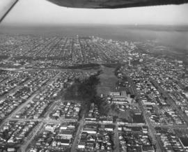
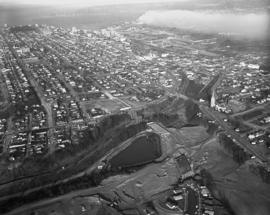
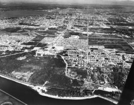
ca. 1961. This aerial photograph from 1961 shows the area immediately west of Orchard Street, and south of 6th Avenue. Starting at the corner of 6th and Orchard (lower left), the main buildings on 6th Ave. are: Boulevard Texaco, 5102 6th Ave.; Busch's 6th Ave. Drive In, 5114 6th Ave., the new First Christian Church, 602 North Orchard (across the street from Busch's), and Stebner's furniture and floor covering, 5510 6th Ave. (near the right edge). The First Christian Church was dedicated February 19, 1961. The road cutting across the photograph at an angle from left to right is Bantz Blvd. with China Lake just above it. The open land next to Busch's is now occupied by the 6th Ave. Kmart. TPL-8788


Aerial photographs; Neighborhoods--Tacoma--1960-1970; Busch's Sixth Avenue Drive-In Restaurant (Tacoma); First Christian Church (Tacoma); Stebner's, Inc. (Tacoma); Boulevard Texaco (Tacoma);

Results 211 to 240 of 824