Aerial Photography

Taxonomy

Code

Scope note(s)

Source note(s)

Display note(s)

Hierarchical terms

Aerial Photography

Equivalent terms

Aerial Photography

Associated terms

Aerial Photography

824 Collections results for Aerial Photography

824 results directly related Exclude narrower terms

D8245-22

ca. 1939. Associated Oil Company aerial view of west side cement plant and construction of west pier for first Narrows Bridge. Ordered by George Martinac, North Pacific Bank Note. TPL-6712


Aerial photographs; Tacoma Narrows Bridge (Tacoma); Bridges--Tacoma;

D8245-5

ca. 1939. Associated Oil Company aerial view of Tacoma, West End to Downtown, tideflats and beyond. Piers for first Narrows Bridge under construction. Ordered by George Martinac, North Pacific Bank Note.


Aerial photographs; Tacoma Narrows Bridge (Tacoma); Bridges--Tacoma;

D8245-7

ca. 1939. Associated Oil Company aerial view of Tacoma West End from Day Island to Point Defiance and beyond. Piers for first Narrows Bridge under construction. Ordered by George Martinac, North Pacific Bank Note.


Aerial photographs; Tacoma Narrows Bridge (Tacoma); Bridges--Tacoma;

D8245-30

ca. 1939. Associated Oil Company aerial view of Tacoma West End showing area above Titlow Beach and Day Island. Photograph taken circa 1939. Ordered by George Martinac, North Pacific Bank Note Company.


Aerial photographs; Titlow Park (Tacoma);

D9334-6

Aerial view of Port Piers on January 13, 1940, showing transport ships. Log booms in background. The three larger vessels are the military transport ships, the Hunter Liggett, Leonard Wood and St. Mihiel. They will be boarding 7500 soldiers from Fort Lewis and taking them to join the 3rd Division Black Army at sea. During the upcoming war games, the Black Army will invade the coast of California from the sea. The games are the largest in US history and involve both the Army and Navy. In 1940, the military was looking ahead to possible involvement in the European conflict which would become World War II. (T. Times 1/11/1940, pg. 1)


Aerial photographs; Bays--Washington (State); Commencement Bay (Wash.); Port of Tacoma (Tacoma)--1940-1950; Logs; Ships;

D9334-7

In this aerial photograph from January 1940, two white Navy transport ships sit at dock in Slip No. One of the Port Industrial Waterway waiting to take on soldiers from Fort Lewis. On Friday January 13th, 7,500 soldiers boarded three transport ships to be carried to California to take part in the largest Army-Navy "war games" exercise ever held on U.S. soil, to that date. When the ships pulled out Saturday morning, Fort Lewis was virtually deserted; only a maintenance staff of a few hundred men stayed behind. (T. Times 1/11/1940, pg. 1)


Aerial photographs; Bays--Washington (State); Commencement Bay (Wash.); Port of Tacoma (Tacoma)--1940-1950; Logs; Ships;

D9334-5

This aerial view, taken January 13, 1940, shows the Port of Tacoma piers with two docked, white transport ships. Three transport ships, the Hunter Liggett, Leonard Wood and St. Mihiel, were in Commencement Bay to transport over 7,500 soldiers from Fort Lewis to the biggest war games in US history. This is the biggest passenger embarkation in the history of the Tacoma port. The troops will invade the California coast from the sea. They will strike at an undisclosed location somewhere on the 400 mile coast between San Francisco and Santa Barbara. This will be the major offensive of the war games to be held January 15-22nd. Also in the photograph are the Co-op's white grain elevators; the waterway is crowded with log booms. The two other cargo vessels pictured are believed to be the South American freighter Coya and the Japanese freighter Koei Maru. ( T. Times 1-3-40, p. 1-article; 1-11-40, p.1-article; 1-13-40, p.1-article)


Aerial photographs; Bays--Washington (State); Commencement Bay (Wash.); Port of Tacoma (Tacoma)--1940-1950; Logs; Ships; Piers & wharves--Tacoma--1940-1950;

D9927-2

This aerial view of McChord Field from June of 1940 shows the U.S. Army's Northwest airbase shortly before it was dedicated on July 3rd. The massive building in the center is the new enlisted men's barracks which could house 1,200 men. In the upper right corner are two of the six-story tall hangers that housed the base's fleet of 24 Douglas B-18A "medium" bombers. The Army had already spent $7 million building the airbase, and millions more would be needed before it was completed. (T.Times 7/1/1940 p.1)


Aerial photographs; McChord Field (Tacoma);

D11701-2

Aerial view of Ferro-Alloys plant on Tideflats. [Also dated 08-01-1941]


Aerial Photographs - Pierce County - Tacoma - Port IndustrialIndustries - Metal Industries

D11794-10

Aerial view of Northern Pacific property at Lakeview. Closer view of land seen in D11794, image 1. This time buildings can faintly be seen in this photograph taken on August 22, 1941. Part of series ordered by Raleigh-Hayward Company.


Aerial photographs; Land; Neighborhoods--Lakewood;

D11794-1

Aerial view of Northern Pacific Rail property at Lakeview which was taken on August 22, 1941. Land is dotted with trees in foreground with thicker forests toward the top of the photograph. Few, if any, homes in sight. Ordered by Raleigh -Hayward Company.


Aerial photographs; Neighborhoods--Lakewood; Land;

D11649-10

This aerial view of the Pierce County Hospital and its surrounding neighborhood was taken in July of 1941. The hospital's new north wing and new west wing were nearing completion. An extra three-mil tax levy was passed in March of 1940 to fund the expansion of the hospital. At the upper left corner is the excavation for the Lincoln Bowl, which was not completed until after WWII. Pierce County took over ownership of the hospital in 2000. (T.Times 7/31/1941 p.5)


Aerial photographs; Pierce County Hospital (Tacoma); Neighborhoods--Tacoma--1940-1950;

D11961-30

Sea-Tac Shipyard, aerial view of facilities. Docks, buildings, equipment and water as photographed in October of 1941.


Aerial photographs; Seattle-Tacoma Shipbuilding Corp. (Tacoma); World War, 1939-1945--Economic & industrial aspects--Tacoma; Boat & ship industry--Tacoma--1940-1950;

D11649-8

Aerial view of downtown Tacoma showing Central Business District and Port/Industrial areas. This view, looking east toward the bustling industrial Tideflats, was taken on July 20, 1941.


Aerial views; Aerial photographs; Cityscapes; Business districts--Tacoma--1940-1950; Commercial streets--Tacoma--1940-1950;

D11649-2

Aerial view of downtown Tacoma including waterfront warehouses and half-moon railroad yards. This July of 1941 photograph, looking westward, shows the densely packed business districts of Tacoma as well as outlying residential areas. The waterway is the City (now Thea Foss) Waterway with the 11th St. Bridge (now Murray Morgan Bridge) in view.


Aerial views; Aerial photographs; Cityscapes; City Waterway (Tacoma); Business districts--Tacoma--1940-1950; Commercial streets--Tacoma--1940-1950;

D11649-6

1941 Aerial view of downtown Tacoma showing the Central Business District, Port/Industrial, and Central residential areas. The 11th St. Bridge (now Murray Morgan Bridge) leads traffic over the City (now Thea Foss) Waterway over to the industrial Tideflats.


Aerial views; Aerial photographs; Cityscapes; City Waterway (Tacoma); Business districts--Tacoma--1940-1950; Commercial streets--Tacoma--1940-1950; 11th Street Bridge (Tacoma);

D11649-13

Aerial view of industrial section of Tacoma taken on July 20, 1941. The business district of downtown Tacoma is in the distance. Various log dumps dot the waterways in the foreground.


Aerial views; Aerial photographs; Cityscapes; Logs; Waterways;

D11649-15

Aerial view of industrial section of Tacoma as seen on July 20, 1941. Log booms in foreground.


Aerial views; Aerial photographs; Logs;

D11649-22

Aerial view of Sea-Tac Shipyard taken on July 20, 1941. Even before the U.S. entered WWII, the Seattle-Tacoma Shipyard was busy with building tankers and C-3 freighters for the government.


Aerial views; Aerial photographs; Seattle-Tacoma Shipbuilding Corp. (Tacoma); Boat & ship industry--Tacoma--1940-1950;

D11649-19

1941 Aerial view of Sea-Tac Shipyard with Peterman Manufacturing Company in foreground, looking west. The Peterman Co. manufactured fir doors and veneer panels. It was forced to vacate the property in June of the following year as the Shipyard needed space to build the many ships under contract.


Aerial views; Aerial photographs; Seattle-Tacoma Shipbuilding Corp. (Tacoma); Boat & ship industry--Tacoma--1940-1950; Peterman Manufacturing Co. (Tacoma);

D11649-16

Aerial view in July of 1941 of industrial section of Tacoma from Commencement Bay looking eastward with focus on various waterways.


Aerial views; Aerial photographs; Waterways;

D12245-8

Aerial view of cleared property above The Narrows showing sparse development in the area east of subject site. Ordered by Mr. Wiborg.


Aerial photographs; Real estate development--Tacoma--1940-1950; Clearing of land--Tacoma--1940-1950; Land subdivision--Tacoma--1940-1950;

D22228-14

This aerial photograph from May of 1946 shows The Narrows and the northwest side of Tacoma north of Sixth Avenue and the entrance to the Narrows Bridge. The wide road at the left is Jackson Avenue, and the large, cleared area of land in the center is "Edward P. Miller's 40 Million Dollar Country Club Estates, Tacoma's Exclusive Residential Development." The roads that cut diagonally across the development (right, bottom to left, top)are now James Street, Narrows Drive, and Fremont. TPL-3810


Aerial photographs; Aerial views; Housing developments--Tacoma--1940-1950; Land subdivision--Tacoma; Clearing of land--Tacoma;

D22228-16

Ponder Sales & Service Inc. sold diesel stove and heavy fuel oils. They were located at 764 Commerce Street. Aerial view ordered by Ponder Sales and Service Co.


Aerial photographs; Aerial views; Roads; H.M. Ponder Oil Sales & Service Co. (Tacoma);

D22153-7

Annie Wright Seminary was a college preparatory school for girls. Miss Ruth Jenkins was the headmistress of the school. Aerial view of Annie Wright Seminary, Commencement Bay in background.


Educational facilities--Tacoma; Private schools--Tacoma; Aerial photographs; Annie Wright Seminary (Tacoma)--Buildings;

D22153-8

Annie Wright Seminary was a college preparatory school for girls. Miss Ruth Jenkins was the headmistress of the school. Aerial view of Annie Wright Seminary, Commencement Bay in background.


Educational facilities--Tacoma; Private schools--Tacoma; Aerial photographs; Annie Wright Seminary (Tacoma)--Buildings;

D25935-5

Aerial photos were taken for the Tacoma Times Business and Industry Review, an eighteen page supplement in the February 26, 1947 edition, highlighting many of Tacoma's industries and businesses. Housing, boat building, machinery manufacturing, chemicals, lumber, paper and pulp, grocery wholesale and fuel were some of the industries featured in the layout. Aerial view of industrial facility with majestic Mount Rainier in background. TPL-10569


Aerial views; Aerial photographs; Industrial facilities--Tacoma; Rainier, Mount (Wash.);

D25712-2

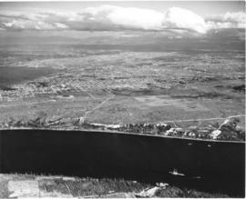
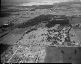
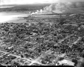
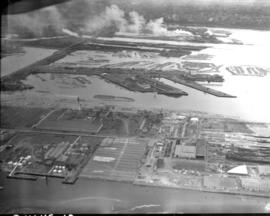
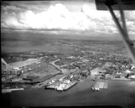
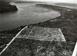
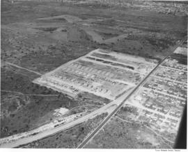
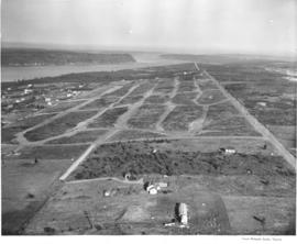
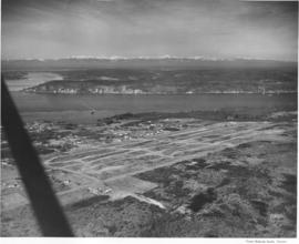
This aerial view of the west side of Tacoma, taken in February, 1947, shows the area north of South 19th and west of Jackson Avenue just north of University Place. Streets have been graded for the future development of Narrowmoor, a residential community of custom built, single-family homes. In 1960, a report by the City of Tacoma stated that Narrowmoor covers an area of 11 blocks by 6 blocks and ranked as "the largest subdivision of quality housing in the city"; all building sites have an excellent view of the Narrows; lots are selling for $5,000 to $8,000; and, homes range in value from $25,000 to $100,000. In 1947 there was no bridge across the narrows. (Report by the City of Tacoma to the Japan Housing and Community Development Team, Tacoma, Washington, August, 1960). TPL-919


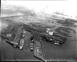
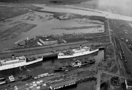
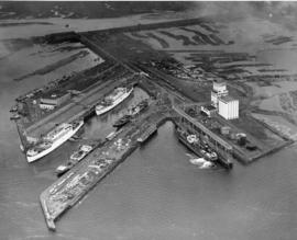
Aerial views; Aerial photographs; Land use--Tacoma;

D25712-8

Aerial view of Hooker Chemicals Plant on the tideflats. A recent merger brought Hooker Electrochemical Company of Tacoma and Niagara Falls, New York and the Detrex Corporation of Detroit, Michigan together, bringing a new company in the chemical industry to Tacoma. The Hooker-Dextrex plant can be seen towards the the top of the image (north), just lower left of the ship yard's water tower. Hooker companies were spread throughout 47 acres in Tacoma (T. Times, 2/26/1947 3B).


Aerial views; Aerial photographs; Waterfronts--Tacoma; Industrial facilities--Tacoma; Hooker Detrex, Inc. (Tacoma); Hooker Electrochemical Co. (Tacoma);

D25712-3

Studio aerial views for Tacoma Times 18 page Business and Industrial Review. Tacoma industries were growing and expanding, gaining national and international recognition. Tacoma was a leader in many industries including: boat and ship building, machinery development, lumber and plywood, chemical plants, grocery wholesalers and flour mills (T. Times, 2/26/1947, Sec. B).


Aerial views; Aerial photographs; Waterfronts--Tacoma; Land use--Tacoma; Industrialization--Tacoma;

Results 661 to 690 of 824