Aerial Photography

Taxonomy

Code

Scope note(s)

Source note(s)

Display note(s)

Hierarchical terms

Aerial Photography

Equivalent terms

Aerial Photography

Associated terms

Aerial Photography

824 Collections results for Aerial Photography

824 results directly related Exclude narrower terms

A116910-6

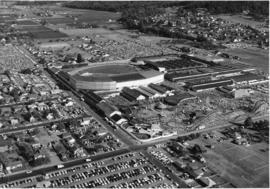
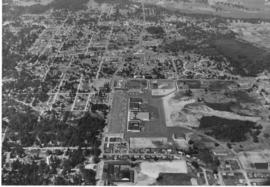
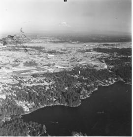
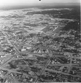
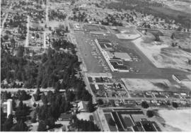
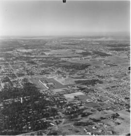
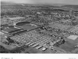
The enormous Grandstand at the Western Washington Fair had been expanded since its construction circa 1908. W.H. Paulhamus served as president of the fair from 1906 to 1925; he acted as announcer and master of ceremonies for the grandstand acts. Hawaiian musicians, Arabian tumbling acts, and parades of livestock entertained viewers in the fair's early days. Later, horse racing became one of the most popular of all attractions on the fairgrounds. View of 1958 Western Washington Fair: Grandstand, exhibition halls, restaurants, and packed parking lots. Emmett Kelly, the world-famous, sad-faced clown, would be making his first West Coast appearance in eight years in twice-daily grandstand shows. For a $1.50, ticketholders could see Kelly, watch the three Zacchinis shot from cannons, admire the Dancing Dalmations, and cheer on three horse races and the cattle parades. Photograph ordered by Puyallup Fair Association. (Souvenir Booklet 50th Western Washington Fair, 1953, TNT 8-20-58, ad) TPL-9295


Aerial photographs; Western Washington Fair (Puyallup); Grandstands--Puyallup;

A116017-2

Mount Rainier was shrouded in clouds on August 8, 1958, when aerial photographs of the future Tacoma Mall area were taken for Allied Owners, Inc. A series of photographs were taken between South 38th & South 56th Streets from Sprague to Pine. The baseball field toward the center of the picture is probably Cheney Field which was on 38th & Lawrence. It is possible that the Tacoma Mall would be in or near the wooded area toward the top of the photograph. This south end area would be further changed with the coming of the freeway in a few years.


Aerial photographs; Aerial views; Neighborhoods--Tacoma--1950-1960;

A116230-1

Aerial photographs taken on an overcast August 14, 1958, show the bustling downtown area and beginnings of the Tideflats. The 11th and 15th St. bridges cross the City (now Thea Foss) Waterway leading to the city's industrial area. The new County-City Building and soon-to-be demolished Courthouse are clearly evident toward the center of the picture. Wright Park is the wooded area nearby. Schoenfelds enormous lettering always captures the camera's eye as it wanders along Pacific Avenue, with Puget Sound National Bank and the Washington Building further up the road. Shuster Parkway is not yet built but its pathway can be imagined near the wooded area close to the 11th St. bridge. The area around 24th & Pacific, including Jefferson, and other portions of downtown Tacoma, were scheduled for an urban renewal project in the late '50's. That area is near the lower left corner by the Union Station. This downtown area would be the home of the future University of Washington-Tacoma campus. TPL-8158


Aerial photographs; Commercial streets--Tacoma--1950-1960;

A116229-1

Lundberg Concrete Pipe Co., Inc., occupied a large stretch of land on Center Street near Pine. Aerial photographs taken on August 14, 1958, show a modern industrial plant surrounded by sections of pipe. Lundberg Concrete also apparently used nearby hillside site for storing large pipes. The company was a family-owned business, headed by Oscar N. Lundberg as president. Allenmore Golf Course appears to be located on the photo's left side. Photograph ordered by Lundberg Concrete Pipe Co., Inc.


Aerial photographs; Lundberg Concrete Pipe Co., Inc. (Tacoma); Pipes (Conduits)--Tacoma; Industrial facilities--Tacoma--1950-1960;

A116230-3

A series of aerial photographs taken by the Richards Studio shows what the downtown area looked like back in the summer of 1958. Several log dumps float in the City (now Thea Foss) Waterway to the right. Union Station, Harmon Mfg. and Hunt & Mottet are clustered toward one end of Pacific Avenue while the large banks and retail stores, including Schoenfelds, are further up the street. Heidelberg Brewing, on South "C", painted large lettering on their rooftop, easily visible from the air. There were still some green spots on the sprawling cityscape, including the massive Wright Park toward to the top.


Aerial photographs; Commercial streets--Tacoma--1950-1960;

A116230-2

A closer view of downtown Tacoma streets taken by air on August 14, 1958, shows the carefully laid out, primarily business district. Heidelberg Brewery was in the 2100 block of South "C" Street, two blocks west of Pacific Avenue, as the street gently curves. The Union Station is in the upper part of the picture, toward the right side. The buildings across the street would become part of the University of Washington-Tacoma campus. The Museum of Glass would also be built on Dock Street, accessible by Chihuly's Bridge of Glass, which would cross busy Pacific Avenue and railroad tracks. The Harmon Mfg. Co. and the Hunt & Mottet Co. buildings on Pacific are easily identifiable in this 1958 photograph. Sections of the downtown area were scheduled for an urban renewal project in the late 1950's. It is believed that the city would have to match some funding from the federal government in order that repairs and remodels of the older section could occur. TPL-10508


Aerial photographs; Commercial streets--Tacoma--1950-1960; Heidelberg Brewing Co. (Tacoma)--1950-1960;

A116227-3

Aerial photographs of the Tideflats area showing the new Educators Manufacturing Co.'s plant on Lincoln Avenue were taken on August 26, 1958. Educators Mfg. made school furniture. The company built a one million dollar facility on ten acres in the Tideflats for mass production of quality controlled classroom equipment. They apparently shared the same address with Buffelen Woodworking & Buffelen Sales Co. View of large plant with three connected buildings. Industrial area to the right of the photograph was the Reichhold Chemicals plant. Photograph ordered by Educators Manufacturing Co. (TNT suppl. 11-9-58, p. 4)


Aerial photographs; Educators Manufacturing Co. (Tacoma); Furniture industry--Tacoma--1950-1960; Industrial facilities--Tacoma--1950-1960;

A116205-1

Aerials of the Tacoma Tideflats industrial area were taken on August 20, 1958, on behalf of the Richards Studio. The Tideflats, already home to railroads, chemical plants and pulp mills, had plenty of room for future expansion. The long narrow street running horizontally is 11th Street with the Milwaukee Way intersecting it. Rows of railroad cars are lined up near the Sitcum and Milwaukee Waterways which are full of log dumps and platforms.


Aerial photographs; Industrial facilities--Tacoma--1950-1960;

A116910-8

This aerial view of the 46-acre Western Washington Fairgrounds, better known as the Puyallup Fair, and the surrounding area was taken on September 15, 1958. Several designated parking lots are crammed full of thousands of cars. Crowds stroll the Midway, enjoying the carnival rides and fair exhibits. The first fair opened on October 5, 1900, and it has run continuously since then, except for the war years of 1942-45. The complete fairgrounds can be seen including the Grandstand, exhibition halls, Midway, restaurants and the three official parking lots. (Photograph ordered by Puyallup Fair Association.) TPL-9273


Aerial views; Western Washington Fair (Puyallup); Grandstands--Puyallup;

A116584-1

Aerial photographs taken on September 9, 1958, show the nearly completed County-City Building on Tacoma Avenue South. The parking lot and landscaping still need to be done. The old Courthouse to the rear of the new building would be the last to be demolished. The land there, too, would become necessary parking. The State Armory, directly behind the Courthouse at 715 South 11th St., still remains. The Tacoma Public Library can be seen to the new County-City Building's right, at 1102 Tacoma Avenue South. Other prominent features include the Schoenfeld's furniture store and Union Station on Pacific Avenue and a portion of the City (now Thea Foss) Waterway. This view, looking southeast, was very similar to A116584-2. Hazy smoke or clouds nearly obliterate Mount Rainier in the distance as well as parts of the industrial Tideflats.


Aerial photographs; Aerial views; County-City Building (Tacoma); Pierce County Courthouse (Tacoma); State Armory (Tacoma); Tacoma Public Library (Tacoma); Streets--Tacoma--1950-1960; Commercial streets--Tacoma--1950-1960;

A116584-2

Aerial photographs taken on September 9, 1958, show the nearly completed County-City Building on Tacoma Avenue South. The parking lot and landscaping still need to be done. The old Courthouse to the rear of the new building would be the last to be demolished. The land there, too, would become necessary parking. The Tacoma Public Library can be seen to the new building's right. Other prominent features include the Schoenfeld's furniture store and Union Station on Pacific Avenue and a portion of the City (now Thea Foss) Waterway. This aerial view was taken looking southeast toward the industrial Tideflats and a hazy Mount Rainier.


Aerial photographs; County-City Building (Tacoma); Pierce County Courthouse (Tacoma); Tacoma Public Library (Tacoma); City Waterway (Tacoma); Rainier, Mount (Wash.);

A116891-1

Aerial photographs of the Pennsylvania Salt Manufacturing Co. of Washington were taken on September 22, 1958. The Tacoma plant covered nearly 40 acres of land in the Tideflats near the Hylebos Waterway. It had easy access to motor and rail transportation as well as water routes. Despite its name, the firm did not manufacture table salt but was a thriving chemical concern, initially focusing on pulp and paper customers. TPL-6577


Aerial photographs; Pennsylvania Salt Manufacturing Co. of Washington (Tacoma); Chemical industry--Tacoma--1950-1960; Industrial facilities--Tacoma--1950-1960;

D116584-10C

ca. 1958. Aerial view of newly built County-City Building, 930 Tacoma Avenue South, circa 1958, and surrounding neighborhood. The building would be dedicated in April of 1959. Directly behind its left wing is the venerable Pierce County Courthouse, 1012 South "G" St., soon to be demolished and ground transformed into parking for the County-City Building. At left lower corner is the Tacoma Public Library, 1102 Tacoma Avenue South.


Aerial views; Aerial photographs; County-City Building (Tacoma); Pierce County Courthouse (Tacoma); Tacoma Public Library (Tacoma); Streets--Tacoma--1950-1960; Commercial streets--Tacoma--1950-1960;

D116584-8C

ca. 1958. Aerial view of the neighborhood around Tacoma Avenue South near the new County-City Building circa 1958. In the center is the County-City Building, with its two wings and tower at 930 Tacoma Avenue South, built to replace the deteriorating Pierce County Courthouse immediately to its rear. The Romanesque old Courthouse at 1012 South "G" would be demolished and the area used as a parking lot. At left center is the Tacoma Public Library, 1102 Tacoma Avenue South. The Central School, 601 South 8th, is at right center edge but McDonald's is yet to be built next door on Tacoma Avenue South.


Aerial views; Aerial photographs; Cityscapes--Tacoma--1950-1960; County-City Building (Tacoma); Pierce County Courthouse (Tacoma); Tacoma Public Library (Tacoma); Central School (Tacoma); Streets--Tacoma--1950-1960;

D116584-9C

ca. 1958. This aerial view is looking west with focus upon the newly built County-City Building at 930 Tacoma Avenue South, circa 1958. The venerable Pierce County Courthouse, directly behind one of the County-City Building wings, was in poor shape and after much discussion, it was decided to build a new structure to replace it. Site preparation and excavation began in 1955 but the building would not be completed until 1959. Also in view are the Tacoma Public Library, directly across the street at 1102 Tacoma Avenue South, and the State Armory at 715 South 11th, behind the Pierce County Courthouse.


Aerial views; Aerial photographs; County-City Building (Tacoma); Pierce County Courthouse (Tacoma); Tacoma Public Library (Tacoma); State Armory (Tacoma); Commercial streets--Tacoma--1950-1960; Streets--Tacoma--1950-1960;

A115843-4

Additional aerial photographs of the Lakewood area surrounding the Villa Plaza Shopping Center were taken by the Richards Studio for a sample book on August 5, 1958. Lakewood was a fast growing community in the 1950's and the developers of the Villa Plaza filled a niche for a large one-stop shopping center. There was plenty of parking available, enough for 4000 cars, and apparently room for further expansion of the center. Aerial photographs of that time showed that there were neatly laid out streets with many trees. Lots were probably larger and less expensive than those within Tacoma city limits. The remodeled Lakewood Center, a smaller shopping center that was Lakewood's first, is almost directly in the center of the picture above the Villa Plaza. TPL-8319


Aerial photographs; Villa Plaza Shopping Center (Lakewood); Shopping centers--Lakewood--1950-1960; Neighborhoods--Lakewood--1950-1960;

A115129-1A

Aerial photographs of the downtown Tacoma area, including the business and financial district, were taken by the Richards Studio on June 16, 1958. This photograph was noted as being "cropped." It shows the 11th St. Bridge as it prepares to cross the City (now Thea Foss) Waterway. Pacific Avenue and A Streets, Saint Helens and Market, Broadway and Commerce are all visible. An observer can identify the Crane Co., the National Bank of Washington, Puget Sound National Bank, the Washington Building with the Mobilgas sign, the Rust Building, Old City Hall with its memorable clock tower, and the skyscraper, the Medical Arts Building. Shuster Parkway will later be built in the thin strip of wooded area adjacent to and under the bridge. TPL-8186


Aerial photographs; Commercial streets--Tacoma--1950-1960; 11th Street Bridge (Tacoma);

A115129-8

Mount Rainier can be seen in the distance through the mist in this aerial photograph of Fox Island taken on June 16, 1958. Heavily wooded Fox Island is located between the Carr Inlet and Hales Passage, two miles northeast of McNeil Island in northwestern Pierce County. It was named in 1841 after Dr. J.L. Fox, an assistant surgeon of the Wilkes Expedition. The Fox Island Bridge can be spotted toward the center of the photograph. It spans 1,981 feet over Hales Passage and was completed in 1954. The bridge was opened by Governor Arthur Langlie and Anne Nelson, the first white girl born on Fox Island. Fox Islanders had to pay tolls on the new bridge; added to the expenses incurred with cars and gasoline, the cost of getting to Tacoma more than doubled. By 1956, the population on the island had declined to 115 families. Nearly a half-century later, according to the 2000 census, there were approximately 2800 people living on Fox Island. (History of Pierce County, Vol. 1, p. 59) TPL-9232


Aerial photographs; Bridges--Fox Island;

A115129-11

Aerial photographs of Tacoma's northend were taken on June 16, 1958. Looking toward Mount Rainier are the industrial Tideflats area. Smoke from many pulp and paper mills drifts over the landscape. The first wooded area nearest downtown would be Wright Park. The second large forested region in the middle is Garfield Park, near Annie Wright Seminary and the Tacoma Lawn Tennis Club, and the distinctive half-moon street. The largest green area, shaped somewhat like a boot, is Puget Park as it was in 1958. It may not be as large now.


Aerial photographs; Parks--Tacoma--1950-1960;

A115129-1

This aerial photographs of downtown Tacoma looking toward Point Defiance was taken on June 16, 1958. Prominent are the three bridges crossing the City (now Thea Foss) Waterway--the 11th St. Bridge, the Railroad Bridge and the 15th St. Bridge. Among a number of identifiable buildings are the massive Schoenfeld's furniture store with its enormous store lettering, the new County-City Building under construction toward the left corner of the photograph, the old County Courthouse behind it, the Washington Building and Puget Sound National Bank, for about two years the tallest building west of the Mississippi (until the Smith Tower was built in Seattle). Wright Park is the heavily wooded area to the right and above of the new County-City Building. Urban renewal had not yet replaced any of the buildings on Pacific Ave. with parking garages. TPL-8676


Aerial photographs; Bridges--Tacoma--1950-1960; County-City Building (Tacoma);

A115129-4

The neatly laid out streets of downtown Tacoma and a portion of the industrial Tideflats area were photographed by airplane on June 16, 1958. Tacoma had concentrated its main financial and business districts in the downtown area. The 11th St. Bridge, visible crossing the City (now Thea Foss) Waterway, extends into the Tideflats. Smoke billows from the various pulp and paper mills in this more sparsely inhabited area. The Tideflats was home to railroad, lumber, and shipbuilding interests.


Aerial photographs; Commercial streets--Tacoma--1950-1960; 11th Street Bridge (Tacoma);

A115847-3

Aerial photographs of the Lakewood area were taken on August 5, 1958. Lake Steilacoom is the large body of water to the foreground. The Villa Plaza Shopping Center is easily spotted as it is surrounded by acres of paved parking lots. McChord Air Force Base, as the group of white buildings, can barely be seen near the right of the photograph. Only the tip of Mount Rainier is clearly visible as mist covers the lower portions. Photograph ordered by Richards Studio for a sample book.


Aerial photographs; Villa Plaza Shopping Center (Lakewood); Lake Steilacoom (Wash.);

A115847-1

Aerial photographs of the Lakewood neighborhoods including Bridgeport and Gravelly Lake Drive were taken on August 2, 1958, by the Richards Studio for inclusion in a sample book. McChord Air Force Base are the white group of buildings near the top of the photograph. The new Villa Plaza Shopping Center is surrounded by a massive paved parking lot. The Lakewood Center, Lakewood's first shopping center constructed in 1937 and remodeled and expanded the early 1950's, is toward the center of the photograph. The Little Church on the Prairie is on Motor Drive, to the right of the Lakewood Center.


Aerial photographs; Villa Plaza Shopping Center (Lakewood); Lakewood Community Center (Lakewood); Shopping centers--Lakewood--1950-1960; Neighborhoods--Lakewood--1950-1960;

A115843-1

Villa Plaza Shopping Center as seen overhead by plane. Aerial photographs of the Villa Plaza Shopping Center in Lakewood were taken on August 5, 1958. Noticeable is the large parking lot with room for 4000 cars. At this time the Villa Plaza had approximately 30 stores including Rhodes, Grants, Penney's, Foreman & Clark and Thriftway supermarket. There appears to still have been room for further expansion to the right of the photograph. The heavily wooded section to the photograph's left may not be there nearly 50 years later; it is probably all housing. Photograph ordered by Dolph Jones.


Aerial photographs; Villa Plaza Shopping Center (Lakewood); Neighborhoods--Lakewood;

A115847-8

Views of suburban Lakewood were taken by plane on August 2, 1958, by Richards Studio for use in a sample book. The new Villa Plaza Shopping Center is toward the center of the picture on Gravelly Lake Drive. It is easy to pick out because of the large cluster of buildings surrounded by the huge parking lot. TPL-8320


Aerial photographs; Villa Plaza Shopping Center (Lakewood); Shopping centers--Lakewood--1950-1960; Neighborhoods--Lakewood--1950-1960;

A113921-5

This aerial view of Tacoma's commercial district was taken in April of 1958. Several log booms float at the south end of the Foss waterway just past the 15th St. Bridge. The tall smokestack near the center is the Dock St. steam plant. The other two bridges are the Railroad Bridge and the Murray Morgan Bridge. Several prominent buildings, including Old City Hall, Puget Sound National Bank, and the Washington Building, are visible. Among current landmarks that are missing: I-705, the Frank Russell Building, and the Columbia Bank Building. TPL-8467


Aerial photographs; Bridges--Tacoma--1950-1960; 11th Street Bridge (Tacoma); Logs;

A113921-4

Aerial photographs of the Puyallup River as it meanders through Tacoma were taken by Richards Studio on April 22, 1958. A close-up view of the three bridges over the river indicate that only the main bridge in the center had any traffic at the time the photograph was snapped. The bridge appears at a definite angle in this particular picture.


Aerial photographs; Bridges--Tacoma; Puyallup River (Wash.);

A113921-7

Aerial views of downtown Tacoma were taken on April 22, 1958. The busy commercial streets showcase many of the city's financial structures. Looking southeast in the center of the picture is Pacific Avenue with the Security Building (formerly Provident Building), the Ionic-columned Bank of California, Washington Building and Puget Sound National Bank, formerly the tallest building on the West Coast. The new Tacoma Building, Weyerhaeuser headquarters, and its predecessor are side-by-side on A Street, one street beyond, with the Perkins Building across the street.


Aerial photographs; Commercial streets--Tacoma--1950-1960; Security Building (Tacoma); Puget Sound National Bank (Tacoma); Bank of California National Association (Tacoma); Washington Building (Tacoma); Perkins Building (Tacoma);

A113921-8

Another view of the bridges crossing the Puyallup River was taken via air by Richards Studio on April 22, 1958. Water levels indicate that the river had not overflooded its borders. There are no buildings directly on the river's edge because of the flooding potential. The white or light gray colored bridge has been identified as the Eells St. bridge looking south. From above it appears to have an open geometric design; the curvature on top is reminiscent of a roller coaster track. It connected Pacific Highway and Fife to the left and Puyallup Ave. and Tacoma to the right. The other two bridges were railroad bridges and still there some fifty years later. (Additional identification provided by a reader)


Aerial photographs; Bridges--Tacoma--1950-1960; Railroad bridges--Tacoma; Eells St. State Highway Bridge (Tacoma); Puyallup River (Wash.);

A113586-1

Woodlam, Inc., was a laminated wood products company located in the Tideflats at 1476 Thorne Rd. William Lindberg was listed as president in the 1959 City Directory. Woodlam was formerly known as Laminated Wood Products Co. and was owned by Arne Strom. Strom had opened the plant in February, 1957, and sold the facility to Lindberg in April, 1958. Woodlam, Inc., employed between 80-100 workers. Purchase of the plant involved eight acres of land, a 500 X 100 foot main plant, drying kilns and a suite of offices. Aerial photographs were taken on April 10, 1958, showing piles of plywood outside the large plant facilities. Railroad tracks close by meant easy rail access for the laminated products. Photograph ordered by Woodlam, Inc. (TNT 4-26-58, A-1)


Aerial photographs; Woodlam, Inc. (Tacoma);

Results 271 to 300 of 824