Aerial Photography

Taxonomy

Code

Scope note(s)

Source note(s)

Display note(s)

Hierarchical terms

Aerial Photography

Equivalent terms

Aerial Photography

Associated terms

Aerial Photography

824 Collections results for Aerial Photography

824 results directly related Exclude narrower terms

D163161-1

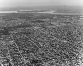
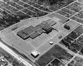
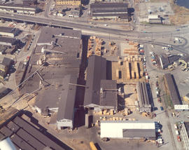
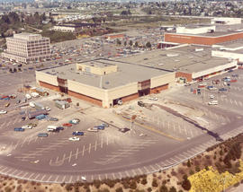
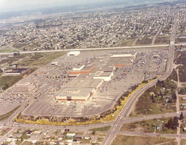
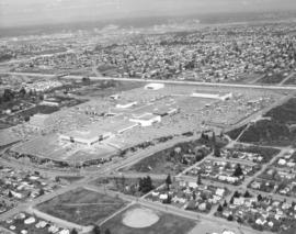
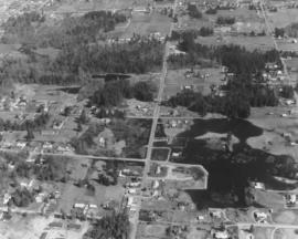
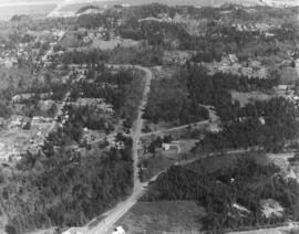
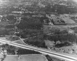
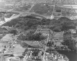
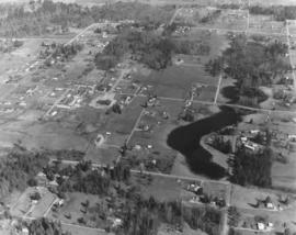
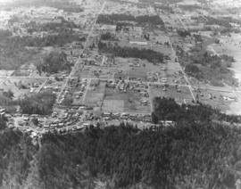
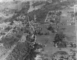
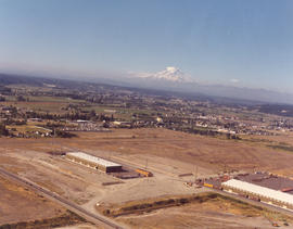
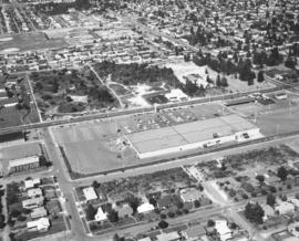
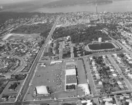
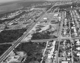
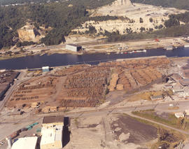
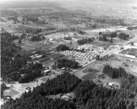
Aerial view looking northwest of the 112th & Meridian area in April of 1973. 112th St. runs diagonally past the Willows Mobile Home Park. At the far right center, according to a reader, was the brand new Willows Shopping Center with Piggly Wiggly and a Pay-N-Save. Just below the center of the photograph was the intersection of 116th St. E. and Meridian. The newer L-shaped building south of the trailer park was another shopping center, later home to MegaFoods, and presently a redeveloped shopping center containing Best Buy. Photograph ordered by Collison Realty. (Additional information provided by a reader)


Aerial views; Neighborhoods--Puyallup--1970-1980;

D163162-15

Looking west from South 56th & Pacific Ave. Aerial view on April 2, 1973, of the densely populated area around the Tacoma Mall. The Mall itself is right-center. Olympics are at the top of the photograph. Photograph ordered by Puget Sound National Bank.


Aerial views; Neighborhoods--Tacoma--1970-1980; Tacoma Mall Shopping Center (Tacoma); Shopping centers--Tacoma--1970-1980;

D163000-326C

ca. 1973. 1973 Richards stock footage. This aerial view features the two large domes leased by Kaiser Aluminum from the Port of Tacoma. The aluminum sheathed domes stored shipments of alumina ore from Australia. Both domes were eventually dismantled about 2005.


Aerial views; Storage tanks--Tacoma; Kaiser Aluminum & Chemical Corp. (Tacoma); Port of Tacoma (Tacoma);

D163162-21

Closer look at the Tacoma Mall Shopping Center as seen by air on April 2, 1973. 25 more stores would open on July 25th bringing the total number of stores found within the Mall to 110. Construction would begin soon on the two-story Rhodes Bros. department store at the far west end. Prominent buildings easily noted in this photograph are the Bon Marche, which was the first occupant of the Mall; the luxurious Tacoma Mall Theatre (bottom center); Pacific National Bank of Washington's circular building; the Bon Marche Tire Center, directly across from the Bon and the six-story Tacoma Mall Office Building. What the Tacoma Mall enjoyed, and downtown shopping lacked, was an abundance of free parking and a climate controlled atmosphere. Access to the Mall was easy with several entrances and quick freeway travel time. The wooded area across the Mall on South 48th St. would eventually become Best Buy, a Pierce County Transit Center, and closer to Pine St., the Social Security office. Ordered by Puget Sound National Bank.


Aerial views; Tacoma Mall Shopping Center (Tacoma); Shopping centers--Tacoma--1970-1980; Parking lots--Tacoma--1970-1980; Bon Marche (Tacoma); Tacoma Mall Theater (Tacoma); Pacific National Bank of Washington (Tacoma); Tacoma Mall Office Building (Tacoma)

D163000-135C

ca. 1973. 1973 Richards stock footage. Unidentified ships docked at Port of Tacoma, as seen by air, in 1973. The Port, then as now, was a busy, bustling place which saw the arrival and departure of many ships during the year.


Aerial views; Vessels; Port of Tacoma (Tacoma);

D163000-394C

1973 Richards stock footage. Color aerial view of the Export Pacific plant, 1942 E. 11th St., as photographed on September 10, 1973. The firm was headed by Chauncey L. Griggs and was involved in the lumber export business.


Aerials views; Export Pacific Co. (Tacoma); Shipping--Tacoma--1970-1980;

D163000-105C

ca. 1973. 1973 Richards stock footage. This may be the 712-foot long tanker, "Achilles," as seen by air, docked at the Port of Tacoma in 1973. She appears to be ready to take on grain from the port's grain elevator. Other unidentified vessels are in the background.


Aerial views; Vessels; Piers & wharves--Tacoma--1970-1980;

C163000-600C

Undated color copy of photograph from the 1973 Richards stock footage. Aerial view of the Grand Coulee Dam and surrounding area. The dam is in the center with Lake Roosevelt behind. The Grand Coulee is a large hydroelectric dam located on the Columbia River.


Aerial views; Dams--Grand Coulee;

C163175-1C

ca. 1973. Copy of customer print ordered on April 5, 1973, by Tacoma Boatbuilding. Colorful aerial view of Tacoma Boatbuilding's 20-acre plant on the Hylebos Waterway. Three cargo ships, including the "Atlantis," are in port. Tacoma Boatbuilding had moved to 1840 Marine View Dr. N.E. in 1969 after fire had destroyed their longtime Sitcum Waterway plant.


Aerial views; Tacoma Boat Building Co., Inc. (Tacoma); Boat & ship industry--Tacoma--1970-1980; Cargo ships--Tacoma; Hylebos Waterway (Tacoma);

D164600-105C

1974 Richards stock footage. Construction of the new Liberty House/Rhodes department store at the Tacoma Mall is proceeding rapidly during the spring of 1974. The two-story building is being built at the Mall's far west end for an estimated $2,000,000. There would be 128,093 square feet of floor space. The store was scheduled to open in the fall of 1974. Also included in this May, 1974, aerial view of the shopping center: the Tacoma Mall Office Building (in rear), the 10-month old west end addition to the Mall, Nordstrom, and the Bon Marche. (TNT 1-13-74, F-8 article)


Aerial views; Aerial photographs; Tacoma Mall Shopping Center (Tacoma); Shopping centers--Tacoma--1970-1980; Building construction--Tacoma--1970-1980; Tacoma Mall Office Building (Tacoma); Bon Marche (Tacoma); Liberty House (Tacoma);

D164600-108C

Aerial view of the City of Tacoma as seen from the industrial Tideflats. The City (now Thea Foss) Waterway separates the bustling industrial area from Tacoma's downtown business district. This May, 1974, photograph aptly captures how the ready availability of rail, water, and highway transport attracted such companies as Hooker Chemicals and St. Regis to Tacoma.


Aerial photographs; Aerial views; City Waterway (Tacoma); Business districts--Tacoma--1970-1980; Industrial facilities--Tacoma;

D164908-4C

Kaiser Aluminum plant. This aerial view of the Kaiser Aluminum plant was taken on June 10, 1974. The plant was located in Tacoma's tideflats at 3400 Taylor Way. The wisps of smoke emerging from the plant's 500-foot stack appear to blend into the heavy cloud formation. Color photograph ordered by Kaiser Aluminum.


Aerial photographs; Kaiser Aluminum & Chemical Corp. (Tacoma); Industrial facilities--Tacoma--1970-1980; Aluminum industry--Tacoma--1970-1980;

D164908-1C

Aerial of Kaiser Aluminum plant as viewed on June 10, 1974. Smoke drifts from the 500-foot stack near the aluminum rod mill. 32 years later in July of 2006, the smokestack was demolished in front of hundreds of fascinated spectators. Color photograph ordered by Kaiser Aluminum.


Aerial photographs; Kaiser Aluminum & Chemical Corp. (Tacoma); Industrial facilities--Tacoma--1970-1980; Aluminum industry--Tacoma--1970-1980;

D164600-104C

1974 Richards stock footage. A look at the Tacoma Mall by air in the spring of 1974 shows that the Mall continues to grow with the building of the new Liberty House/Rhodes department store at the Mall's extreme west end. The store was scheduled to open that fall. I-5 runs nearly vertically at the photograph's right, allowing easy access to the shopping center. The wooded area east of the freeway would eventually be dotted with new homes; businesses would also take the place of the homes located at the bottom of the photograph.


Aerial views; Aerial photographs; Tacoma Mall Shopping Center (Tacoma); Shopping centers--Tacoma--1970-1980; Neighborhoods--Tacoma--1970-1980; Express highways--Tacoma--1970-1980;

D164600-101

1974 Richards stock footage. Aerial view of the Tacoma Mall and surrounding south end neighborhoods. This May, 1974, view by air makes it plain that one of the main attributes of this popular shopping center was its ready access by freeway and its enormous free parking lots. Should a visitor to the Mall decide to bypass the freeway, the Mall would still be accessible through well traveled local streets such as Pine, South 38th and South 48th. The Mall had opened its west end addition in July of 1973 to add 20 more stores to the shopping center; in May of 1974, construction was proceeding rapidly with the new Liberty House/Rhodes department store at the far west end of the shopping center. TPL-5876


Aerial views; Aerial photographs; Tacoma Mall Shopping Center (Tacoma); Shopping centers--Tacoma--1970-1980; Express highways--Tacoma--1970-1980; Neighborhoods--Tacoma--1970-1980;

D165802-2

Aerial photographs of the area between 320th in Federal Way, North Puyallup, Pacific Highway South and Valley Ave. were taken on a clear day in late March, 1975. This particular view was not positively identified. Lot sizes appeared large and the area not densely occupied. There are two lakes/ponds visible. Photograph ordered by Puget Sound National Bank.


Aerial views; Aerial photographs; Lakes & ponds--Washington;

D165802-14

Puget Sound National Bank had requested aerial photographs of the land between 320th in Federal Way, North Puyallup, Pacific Highway South and Valley Ave. in late March of 1975. The area shown above is heavily wooded with small neighborhoods scattered among the trees.


Aerial views; Firs;

D165802-35

On March 27, 1975, several aerial photographs were taken by the Richards Studio of the area between 320th in Federal Way, North Puyallup, Pacific Highway South and Valley Ave. for Puget Sound National Bank. Most of the series shown the abundance of wooded areas and undeveloped property with smaller neighborhoods scattered on the landscape. The aerials also noted the many roadways, including freeways, in the area.


Aerial views; Express highways--Wash;

D165802-12

A series of aerial photographs were taken on March 27, 1975, on behalf of Puget Sound National Bank of the area between 320th in Federal Way, North Puyallup, Pacific Highway South and Valley Ave. The purpose for the photographs was not expressed in Richard studio notes but it is possible that the bank was preparing for the later acquisition of banks in the vicinity.


Aerial views;

D165802-5

A series of photographs were taken on March 27, 1975, on behalf of Puget Sound National Bank of the area between 320th in Federal Way, North Puyallup, Pacific Highway and Valley Ave. These aerial views of thirty years past show relatively undeveloped areas with little traffic.


Aerial views;

D165802-48

Aerial view, taken in March of 1975, of communities interspersed among large sections of firs. According to Richard Studio notes, the firm had been requested to take a series of photographs of the region between 320th in Federal Way, North Puyallup, Pacific Highway South and Valley Ave. for Puget Sound National Bank.


Aerial views; Firs;

D165802-6

Aerial view of heavily wooded lands possibly in the North Puyallup/Valley Ave location. This view has undoubtedly changed in the 32 years since the photograph was taken on behalf of Puget Sound National Bank.


Aerial views; Firs;

D165187-1

ca. 1974. This view of the Kaiser Aluminum plant is a cropped version of D165187, image A. It was taken circa 1974 with the focus on the 500-foot stack near right center. The stack was built in 1968, the same year Kaiser's new aluminum rod mill commenced operation.


Aerial views; Kaiser Aluminum & Chemical Corp. (Tacoma); Industrial facilities--Tacoma--1970-1980; Aluminum industry--Tacoma--1970-1980; Smokestacks--Tacoma;

D165802-25

The landscape above has probably changed in the 30+ years since this Richards Studio photograph was taken. More homes have probably been built and traffic, barely seen above, increased. This aerial is possibly in the North Puyallup section of the county. Photograph ordered by Puget Sound National Bank.


Aerial views;

D165022-3C

Aerial color view of Tacoma's industrial Tideflats area in the summer of 1974, taken on behalf of Pan Pacific Trading Co., log exporters. This particular business, with plenty of empty land surrounding it, has not been positively identified. Mount Rainier in background with snowy tip emerging from cloud cover.


Aerial views; Industrial facilities--Tacoma--1970-1980; Rainier, Mount (Wash.);

D165044-20

Closer look by air at Pearl St. in Tacoma's west end. Pearl St. is the street farthest left running vertically toward Point Defiance. Parallel to Pearl is Orchard St. with the playing fields of Wilson High School nearby. North 11th St. runs horizontally intersecting Orchard and Pearl. The Auto View Drive-In is to the left of Pearl. ASARCO's famous smokestack is clearly visible near the top of the photograph. Photograph ordered by Puget Sound National Bank.


Aerial views; Neighborhoods--Tacoma--1970-1980; Auto View Drive-In (Tacoma); Smokestacks--Tacoma;

D165044-16

This section of Sixth Avenue looks a bit different now than it did in 1974. Kmart, with its 1000-car parking lot, is still there but the area directly across the street has been dotted with small shopping malls. In 1974 the only business immediately across Kmart was a new Goodyear store which would celebrate its grand opening at the tail end of October, 1974. The First Christian Church is set on a large wooded lot close to Goodyear. Wilson High School, 12th & Orchard, is the cluster of buildings near the top left center. Aerial photograph ordered by Puget Sound National Bank.


Aerial views; Neighborhoods--Tacoma--1970-1980; Kmart (Tacoma); Parking lots--Tacoma--1970-1980; Goodyear Service (Tacoma); First Christian Church (Tacoma); Woodrow Wilson High School (Tacoma);

D165044-11

Aerial view of the Westgate neighborhood, taken via helicopter on August 28, 1974, on behalf of Puget Sound National Bank. Shopping center below is the Westgate Shopping Center at North 26th & Pearl St. The Westgate Thriftco (formerly known as Thriftway) was one of the main tenants. North 26th runs horizontally at bottom of the photograph; it intersects with Pearl Street on the left. Pearl is the extremely long street that will eventually end at Point Defiance Park. Other landmarks clearly visible include the North 30th St. reservoir and water tower at photo's right-center and ASARCO's smokestack at top.


Aerial views; Neighborhoods--Tacoma--1970-1980; Westgate Shopping Center (Tacoma); Reservoirs--Tacoma; Water towers--Tacoma; Thriftco (Tacoma); Smokestacks--Tacoma;

D165044-22

Westgate Shopping Center and environs via helicopter on August 28, 1974. The Westgate Shopping Center at North 26th & Pearl would later expand to include the large block across North 26th St. Most of the lot was undeveloped at the time of this 1974 photograph. Major streets on display are Pearl and Orchard St. (running vertically and parallel to one another) intersected by North 21st and North 26th. The North 30th St. water tower and reservoir is located at the upper right corner. Photograph ordered by Puget Sound National Bank.


Aerial views; Neighborhoods--Tacoma--1970-1980; Westgate Shopping Center (Tacoma); Water towers--Tacoma; Reservoirs--Tacoma;

D165022-7C

Log storage along the Hylebos Waterway. Pan Pacific Trading were log exporters with locations at 3502 Lincoln Ave and Yard 2 at 2407 Port of Tacoma Rd. This August, 1974, aerial shows the large Pan Pacific lot filled with stacks of logs. Color photograph ordered by Pan Pacific Trading Co.


Aerial views; Pan Pacific Trading Co. (Tacoma); Logs; Lumber industry--Tacoma--1970-1980; Shipping--Tacoma--1970-1980; Hylebos Waterway (Tacoma);

Results 31 to 60 of 824