Aerial Photography

Taxonomy

Code

Scope note(s)

Source note(s)

Display note(s)

Hierarchical terms

Aerial Photography

Equivalent terms

Aerial Photography

Associated terms

Aerial Photography

824 Collections results for Aerial Photography

824 results directly related Exclude narrower terms

A115843-1

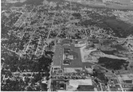
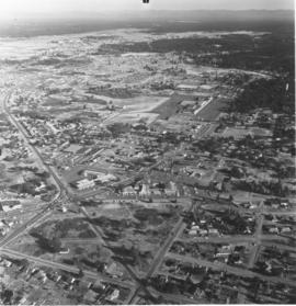
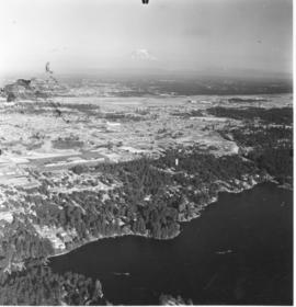
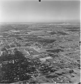
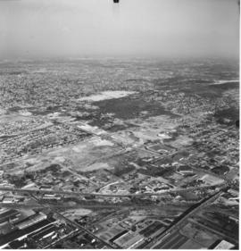
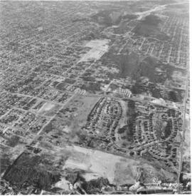
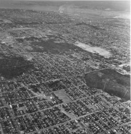
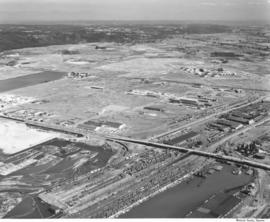
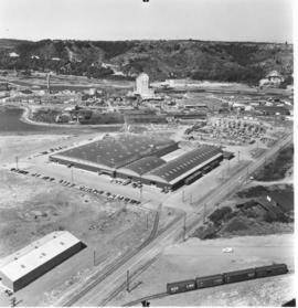
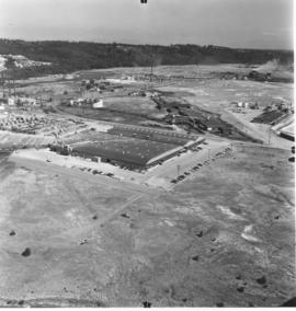
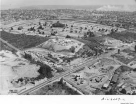
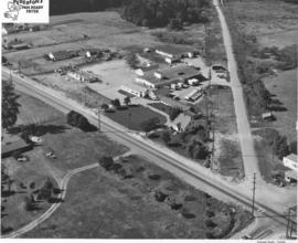
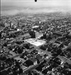
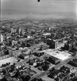
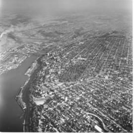
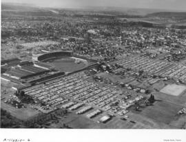
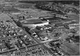
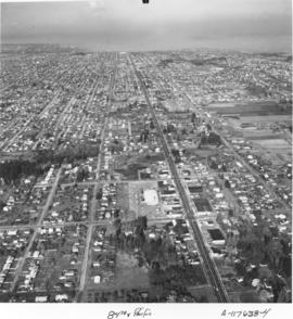
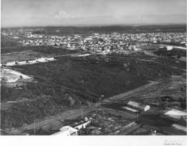
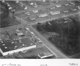
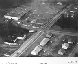
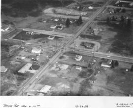
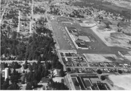
Villa Plaza Shopping Center as seen overhead by plane. Aerial photographs of the Villa Plaza Shopping Center in Lakewood were taken on August 5, 1958. Noticeable is the large parking lot with room for 4000 cars. At this time the Villa Plaza had approximately 30 stores including Rhodes, Grants, Penney's, Foreman & Clark and Thriftway supermarket. There appears to still have been room for further expansion to the right of the photograph. The heavily wooded section to the photograph's left may not be there nearly 50 years later; it is probably all housing. Photograph ordered by Dolph Jones.


Aerial photographs; Villa Plaza Shopping Center (Lakewood); Neighborhoods--Lakewood;

A115843-4

Additional aerial photographs of the Lakewood area surrounding the Villa Plaza Shopping Center were taken by the Richards Studio for a sample book on August 5, 1958. Lakewood was a fast growing community in the 1950's and the developers of the Villa Plaza filled a niche for a large one-stop shopping center. There was plenty of parking available, enough for 4000 cars, and apparently room for further expansion of the center. Aerial photographs of that time showed that there were neatly laid out streets with many trees. Lots were probably larger and less expensive than those within Tacoma city limits. The remodeled Lakewood Center, a smaller shopping center that was Lakewood's first, is almost directly in the center of the picture above the Villa Plaza. TPL-8319


Aerial photographs; Villa Plaza Shopping Center (Lakewood); Shopping centers--Lakewood--1950-1960; Neighborhoods--Lakewood--1950-1960;

A115847-1

Aerial photographs of the Lakewood neighborhoods including Bridgeport and Gravelly Lake Drive were taken on August 2, 1958, by the Richards Studio for inclusion in a sample book. McChord Air Force Base are the white group of buildings near the top of the photograph. The new Villa Plaza Shopping Center is surrounded by a massive paved parking lot. The Lakewood Center, Lakewood's first shopping center constructed in 1937 and remodeled and expanded the early 1950's, is toward the center of the photograph. The Little Church on the Prairie is on Motor Drive, to the right of the Lakewood Center.


Aerial photographs; Villa Plaza Shopping Center (Lakewood); Lakewood Community Center (Lakewood); Shopping centers--Lakewood--1950-1960; Neighborhoods--Lakewood--1950-1960;

A115847-3

Aerial photographs of the Lakewood area were taken on August 5, 1958. Lake Steilacoom is the large body of water to the foreground. The Villa Plaza Shopping Center is easily spotted as it is surrounded by acres of paved parking lots. McChord Air Force Base, as the group of white buildings, can barely be seen near the right of the photograph. Only the tip of Mount Rainier is clearly visible as mist covers the lower portions. Photograph ordered by Richards Studio for a sample book.


Aerial photographs; Villa Plaza Shopping Center (Lakewood); Lake Steilacoom (Wash.);

A115847-8

Views of suburban Lakewood were taken by plane on August 2, 1958, by Richards Studio for use in a sample book. The new Villa Plaza Shopping Center is toward the center of the picture on Gravelly Lake Drive. It is easy to pick out because of the large cluster of buildings surrounded by the huge parking lot. TPL-8320


Aerial photographs; Villa Plaza Shopping Center (Lakewood); Shopping centers--Lakewood--1950-1960; Neighborhoods--Lakewood--1950-1960;

A116017-2

Mount Rainier was shrouded in clouds on August 8, 1958, when aerial photographs of the future Tacoma Mall area were taken for Allied Owners, Inc. A series of photographs were taken between South 38th & South 56th Streets from Sprague to Pine. The baseball field toward the center of the picture is probably Cheney Field which was on 38th & Lawrence. It is possible that the Tacoma Mall would be in or near the wooded area toward the top of the photograph. This south end area would be further changed with the coming of the freeway in a few years.


Aerial photographs; Aerial views; Neighborhoods--Tacoma--1950-1960;

A116017-4

This aerial photograph, taken for Allied Owners, Inc. in August of 1958, shows the area of South Tacoma that would become home to the Tacoma Mall Shopping Center. The winding, twisting roads toward the lower center are the Lincoln Heights neighborhood. The road on the far right is South Pine. South 38th Street cuts through the middle of the photo from left to right. The tree covered area at right center is now the site of the Tacoma Mall. I-5 is yet to be built. At the top is Wapato Park and Wapato Lake.


Aerial photographs; Neighborhoods--Tacoma;

A116017-5

The South Tacoma area would be experiencing many changes in the late 1950's with the coming of the Tacoma Mall and the freeways. Aerial photographs taken for Allied Owners, Inc., on August 8, 1958, show the carefully laid out streets of the South Tacoma. It shows South 56th Street running from left to right across the center of the picture to the wooded area at the right, Wapato Hills. The church with the tall steeple in the left corner is the Church of Visitation on South 58th St. The area where the Tacoma Mall would eventually be built may have been in or close to the woods in the upper center of the photograph, next to the flat L shaped area.


Aerial photographs; Neighborhoods--Tacoma;

A116205-1

Aerials of the Tacoma Tideflats industrial area were taken on August 20, 1958, on behalf of the Richards Studio. The Tideflats, already home to railroads, chemical plants and pulp mills, had plenty of room for future expansion. The long narrow street running horizontally is 11th Street with the Milwaukee Way intersecting it. Rows of railroad cars are lined up near the Sitcum and Milwaukee Waterways which are full of log dumps and platforms.


Aerial photographs; Industrial facilities--Tacoma--1950-1960;

A116227-2

Educators Manufacturing Co., makers of school furniture, opened a new plant in the Tideflats area in 1958. Located at 3401 Lincoln Avenue, close to Taylor Way, the company shared the same address with Buffelen Woodworking & Buffelen Sales Co. The million dollar plant was located on a sprawling ten acre industrial site in the Tideflats. 133,000 square feet of plant space handled mass production of quality controlled classroom equipment. All production processes were located on one floor which reduced material handling cost. Hart Construction Co. were the general contractors. View of large plant, apparently divided into three sections, all with gently curved roofs. There is a large parking lot bordered by stacks of plywood. Washington Cooperative Farmers Feed Mill looms in the background. Photograph ordered by Educators Manufacturing Co. (TNT suppl. 11-9-58, p. 4) TPL-9831


Aerial photographs; Educators Manufacturing Co. (Tacoma); Furniture industry--Tacoma--1950-1960; Industrial facilities--Tacoma--1950-1960;

A116227-3

Aerial photographs of the Tideflats area showing the new Educators Manufacturing Co.'s plant on Lincoln Avenue were taken on August 26, 1958. Educators Mfg. made school furniture. The company built a one million dollar facility on ten acres in the Tideflats for mass production of quality controlled classroom equipment. They apparently shared the same address with Buffelen Woodworking & Buffelen Sales Co. View of large plant with three connected buildings. Industrial area to the right of the photograph was the Reichhold Chemicals plant. Photograph ordered by Educators Manufacturing Co. (TNT suppl. 11-9-58, p. 4)


Aerial photographs; Educators Manufacturing Co. (Tacoma); Furniture industry--Tacoma--1950-1960; Industrial facilities--Tacoma--1950-1960;

A116229-1

Lundberg Concrete Pipe Co., Inc., occupied a large stretch of land on Center Street near Pine. Aerial photographs taken on August 14, 1958, show a modern industrial plant surrounded by sections of pipe. Lundberg Concrete also apparently used nearby hillside site for storing large pipes. The company was a family-owned business, headed by Oscar N. Lundberg as president. Allenmore Golf Course appears to be located on the photo's left side. Photograph ordered by Lundberg Concrete Pipe Co., Inc.


Aerial photographs; Lundberg Concrete Pipe Co., Inc. (Tacoma); Pipes (Conduits)--Tacoma; Industrial facilities--Tacoma--1950-1960;

A116229-2

Aerial photographs taken on August 14, 1958, of the Center & Pine area paint an almost surrealistic view of the surroundings. The Lundberg Concrete Pipe Co. is the cluster of buildings located near the center of the picture. As their name indicates, they were pipe manufacturers. Located on top of a neighboring hillside is the storage area for the pipes. Beyond Lundberg Concrete appears to be the Allenmore Golf Course. Photograph ordered by Lundberg Concrete Pipe Co., Inc.


Aerial photographs; Lundberg Concrete Pipe Co., Inc. (Tacoma); Pipes (Conduits)--Tacoma; Industrial facilities--Tacoma;

A116230-1

Aerial photographs taken on an overcast August 14, 1958, show the bustling downtown area and beginnings of the Tideflats. The 11th and 15th St. bridges cross the City (now Thea Foss) Waterway leading to the city's industrial area. The new County-City Building and soon-to-be demolished Courthouse are clearly evident toward the center of the picture. Wright Park is the wooded area nearby. Schoenfelds enormous lettering always captures the camera's eye as it wanders along Pacific Avenue, with Puget Sound National Bank and the Washington Building further up the road. Shuster Parkway is not yet built but its pathway can be imagined near the wooded area close to the 11th St. bridge. The area around 24th & Pacific, including Jefferson, and other portions of downtown Tacoma, were scheduled for an urban renewal project in the late '50's. That area is near the lower left corner by the Union Station. This downtown area would be the home of the future University of Washington-Tacoma campus. TPL-8158


Aerial photographs; Commercial streets--Tacoma--1950-1960;

A116230-2

A closer view of downtown Tacoma streets taken by air on August 14, 1958, shows the carefully laid out, primarily business district. Heidelberg Brewery was in the 2100 block of South "C" Street, two blocks west of Pacific Avenue, as the street gently curves. The Union Station is in the upper part of the picture, toward the right side. The buildings across the street would become part of the University of Washington-Tacoma campus. The Museum of Glass would also be built on Dock Street, accessible by Chihuly's Bridge of Glass, which would cross busy Pacific Avenue and railroad tracks. The Harmon Mfg. Co. and the Hunt & Mottet Co. buildings on Pacific are easily identifiable in this 1958 photograph. Sections of the downtown area were scheduled for an urban renewal project in the late 1950's. It is believed that the city would have to match some funding from the federal government in order that repairs and remodels of the older section could occur. TPL-10508


Aerial photographs; Commercial streets--Tacoma--1950-1960; Heidelberg Brewing Co. (Tacoma)--1950-1960;

A116230-3

A series of aerial photographs taken by the Richards Studio shows what the downtown area looked like back in the summer of 1958. Several log dumps float in the City (now Thea Foss) Waterway to the right. Union Station, Harmon Mfg. and Hunt & Mottet are clustered toward one end of Pacific Avenue while the large banks and retail stores, including Schoenfelds, are further up the street. Heidelberg Brewing, on South "C", painted large lettering on their rooftop, easily visible from the air. There were still some green spots on the sprawling cityscape, including the massive Wright Park toward to the top.


Aerial photographs; Commercial streets--Tacoma--1950-1960;

A116582-2

A new building was under construction at the large Pederson Fryer Farms complex at 2901 East 72nd when this aerial photograph was taken on September 7, 1958. The automatic poultry processing equipment at Pederson's had the capacity to dress and package 2,500 chickens per hour. At that time, Pederson's employed 88 people. The family personally supervised the raising of special hybrids and controlled their feeding and housing. By the 1990s they were Washington State's largest producer of poultry with 450 employees. After 48 years in the poultry business, Pederson Farms declared bankruptcy in 1996; they were bought out by Foster Farms of Modesto, California in 1997. Photograph ordered by Pederson Fryer Farms.


Aerial photographs; Pederson Fryer Farms (Tacoma);

A116584-1

Aerial photographs taken on September 9, 1958, show the nearly completed County-City Building on Tacoma Avenue South. The parking lot and landscaping still need to be done. The old Courthouse to the rear of the new building would be the last to be demolished. The land there, too, would become necessary parking. The State Armory, directly behind the Courthouse at 715 South 11th St., still remains. The Tacoma Public Library can be seen to the new County-City Building's right, at 1102 Tacoma Avenue South. Other prominent features include the Schoenfeld's furniture store and Union Station on Pacific Avenue and a portion of the City (now Thea Foss) Waterway. This view, looking southeast, was very similar to A116584-2. Hazy smoke or clouds nearly obliterate Mount Rainier in the distance as well as parts of the industrial Tideflats.


Aerial photographs; Aerial views; County-City Building (Tacoma); Pierce County Courthouse (Tacoma); State Armory (Tacoma); Tacoma Public Library (Tacoma); Streets--Tacoma--1950-1960; Commercial streets--Tacoma--1950-1960;

A116584-2

Aerial photographs taken on September 9, 1958, show the nearly completed County-City Building on Tacoma Avenue South. The parking lot and landscaping still need to be done. The old Courthouse to the rear of the new building would be the last to be demolished. The land there, too, would become necessary parking. The Tacoma Public Library can be seen to the new building's right. Other prominent features include the Schoenfeld's furniture store and Union Station on Pacific Avenue and a portion of the City (now Thea Foss) Waterway. This aerial view was taken looking southeast toward the industrial Tideflats and a hazy Mount Rainier.


Aerial photographs; County-City Building (Tacoma); Pierce County Courthouse (Tacoma); Tacoma Public Library (Tacoma); City Waterway (Tacoma); Rainier, Mount (Wash.);

A116891-1

Aerial photographs of the Pennsylvania Salt Manufacturing Co. of Washington were taken on September 22, 1958. The Tacoma plant covered nearly 40 acres of land in the Tideflats near the Hylebos Waterway. It had easy access to motor and rail transportation as well as water routes. Despite its name, the firm did not manufacture table salt but was a thriving chemical concern, initially focusing on pulp and paper customers. TPL-6577


Aerial photographs; Pennsylvania Salt Manufacturing Co. of Washington (Tacoma); Chemical industry--Tacoma--1950-1960; Industrial facilities--Tacoma--1950-1960;

A116893-2

The Richards Studio went aloft on a cloudy September 22, 1958, to take views of the Tacoma landscape. Smoke billows from the industrial Tideflats area. View of city's downtown area includes 11th St. Bridge, City (now Thea Foss) Waterway, heavily wooded Wright Park, and new County-City Building. Streets are neatly aligned with trees on most residential lots. The Tacoma Lawn Tennis Club can be spotted near the right lower corner with its unusual curved streets.


Aerial photographs; Tacoma Lawn Tennis Club (Tacoma);

A116910-6

The enormous Grandstand at the Western Washington Fair had been expanded since its construction circa 1908. W.H. Paulhamus served as president of the fair from 1906 to 1925; he acted as announcer and master of ceremonies for the grandstand acts. Hawaiian musicians, Arabian tumbling acts, and parades of livestock entertained viewers in the fair's early days. Later, horse racing became one of the most popular of all attractions on the fairgrounds. View of 1958 Western Washington Fair: Grandstand, exhibition halls, restaurants, and packed parking lots. Emmett Kelly, the world-famous, sad-faced clown, would be making his first West Coast appearance in eight years in twice-daily grandstand shows. For a $1.50, ticketholders could see Kelly, watch the three Zacchinis shot from cannons, admire the Dancing Dalmations, and cheer on three horse races and the cattle parades. Photograph ordered by Puyallup Fair Association. (Souvenir Booklet 50th Western Washington Fair, 1953, TNT 8-20-58, ad) TPL-9295


Aerial photographs; Western Washington Fair (Puyallup); Grandstands--Puyallup;

A116910-8

This aerial view of the 46-acre Western Washington Fairgrounds, better known as the Puyallup Fair, and the surrounding area was taken on September 15, 1958. Several designated parking lots are crammed full of thousands of cars. Crowds stroll the Midway, enjoying the carnival rides and fair exhibits. The first fair opened on October 5, 1900, and it has run continuously since then, except for the war years of 1942-45. The complete fairgrounds can be seen including the Grandstand, exhibition halls, Midway, restaurants and the three official parking lots. (Photograph ordered by Puyallup Fair Association.) TPL-9273


Aerial views; Western Washington Fair (Puyallup); Grandstands--Puyallup;

A117142-3

Although Annie Wright Seminary had been at this location, 827 Tacoma Ave. No., only since 1924; it was in the process of celebrating its Diamond Jubilee in October of 1958 when this picture was taken. The first class of 93 girls entered Annie Wright in the fall of 1884 in the school's first building at Tacoma & Division Avenues. Annie Wright experienced financial troubles due to decreased enrollment in the 1930's and increased expenses during the early part of WWII; the school was nearly forced to close in 1943. Headmistress Ruth Jenkins and the Board of Trustees were given 48 hours to raise enough money to pay the most outstanding debts. Friends, alumnae and students rallied to save the school. Annie Wright Seminary continued to expand with a new wing added in 1957. In 2002, the school had pupils from seven states and eight countries and was planning to add a 10.3 million three story addition. (The Shield:1959, TNT 9-30-02, B-1)


Aerial photographs; Annie Wright Seminary (Tacoma)--1950-1960; Private schools--Tacoma;

A117638-1

Aerial photographs taken on behalf of George Franklin on November 3, 1958, of the South 84th and Pacific Avenue neighborhoods show a growing southend presence in the city. While there appears to be room for development, Pacific Avenue around this area is starting to develop with many businesses. Safeway, Vaughan's Pacific Avenue Lumber and Puget Sound National Bank all are close by.


Aerial photographs; Neighborhoods--Tacoma--1950-1960;

A117638-4

Aerial photographs taken on November 3, 1958, show Tacoma city streets neatly gridded and stretching into the horizon. This area was the South 84th & Pacific Avenue neighborhood. A few large businesses had started to relocate to this southend location including Puget Sound National Bank, Safeway, and Vaughan's Pacific Avenue Lumber Co. Pacific Avenue was a major thoroughfare and businesses located on or near it attracted much drive-by traffic. Photograph ordered by George Franklin.


Aerial photographs; Neighborhoods--Tacoma--1950-1960;

A118085-1

Aerial photographs of the Skyline Terrace neighborhood were taken in November, 1958, by the Richards Studio for a sample book. Immense tracts of trees surround the North end neighborhood close to the Narrows Bridge. Skyline Terrace was an exclusive neighborhood developed by builder Ed Miller; all homes had views of either the Narrows Bridge, the mountains or city lights. This photograph was supposedly taken in the vicinity of No. 11th & James.


Aerial photographs; Neighborhoods--Tacoma--1950-1960;

A118700-11

It appears that new construction is going up in the vicinity of E. 40th & Portland Ave. in late December, 1958. The smaller unit closer to the intersection is a gas station. The identity of the larger rectangular building is not certain; it may have been a grocery store. The carefully spaced houses across the street from the gas station are part of the Salishan housing project, which was originally built as housing for war workers and military families. The first family moved into Salishan in 1943; the neighborhood consisted of one-story units, single family, duplexes, and four-family units. Aerial photographs were taken on December 22, 1958, by the Richards Studio for a sample book.


Aerial photographs; Neighborhoods--Tacoma--1950-1960;

A118700-13

Aerial photographs of the E. 40th & Portland Avenue neighborhood were taken on December 22, 1958, by the Richards Studio for inclusion in a sample book. A church and Dairy Queen stand side-by-side across the street from the neatly aligned homes of the Salishan housing development. Each unit in Salishan had a fairly large grass yard; clothes can be spotted hanging to dry in the backyards. New construction is taking place in the upper left hand corner as a gas station and another large building, a new Piggly Wiggly supermarket, are being built. The Piggly Wiggly would open on March 18, 1959. (Additional information provided by a reader)


Aerial photographs; Neighborhoods--Tacoma--1950-1960; Building construction--Tacoma--1950-1960;

A118700-17

Aerial photographs of the 111st St. and Bridgeport Way S.W. neighborhood were taken by Richards on December 22, 1958. They were photographing various city neighborhoods by air that day for inclusion in sample books. This area was also known as Lakeview. Belcher Realty's large signage on Bridgeport can be clearly seen from the air; it was owned and operated by Lyle V. Belcher, broker. The realty firm handled homes, farms, acreage and insurance in the Lakes area. Next to Belcher's was Bridgeport Service, a gas station owned by Wesley Baker and James Bohannon. The Bell Fuel Co. had their suburban facility on 111st St. It was a Mobilheat dealer and sold stove and diesel oil. It is possible that across the street from Bell Fuel was the A.A. Meat Co.


Aerial photographs; Neighborhoods--Lakewood--1950-1960; Belcher Realty (Lakewood); Bell Fuel Co. (Lakewood);

Results 31 to 60 of 824