Aerial Photography

Taxonomy

Code

Scope note(s)

Source note(s)

Display note(s)

Hierarchical terms

Aerial Photography

Equivalent terms

Aerial Photography

Associated terms

Aerial Photography

824 Collections results for Aerial Photography

824 results directly related Exclude narrower terms

A66035-36

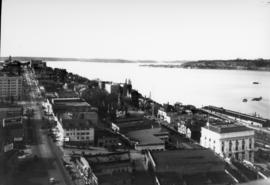
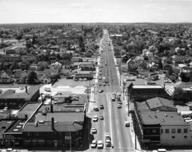
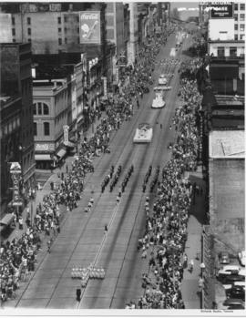
Aerial view of 1952 Daffodil Parade as it proceeds down Pacific Avenue. The 15 mile long parade wound its way down Pacific Ave. from 9th to 19th. A Marine Corps color guard led the parade, followed by the float bearing Queen Eva Beattie and her princesses, royally escorted by the Rosarians of Portland, Oregon. Following the City Light float bearing the Queen were 70 floats and decorated cars, 21 bands, 28 marching units and three mounted groups. (TNT 4-6-1952, pg. 1)


Celebrations--Tacoma; Festivals--Tacoma; Parades & Processions--Tacoma--1950-1960; Puyallup Valley Daffodil Festival (1952 : Tacoma); Drill teams; Marching bands; Floats (parades)--Tacoma--1950-1960; Aerial photographs;

D67903-9

ca. 1952. Aerial view of Northern King County, north of Seattle and west of Lake Washington. The large building on the left with the marquee is most probably the Crest Movie Cinema, located at 16505 5th Ave. NE, Seattle. The homes here appear to mid sized and are located on large lots. The streets are laid out on a square block formation. There are still large sections of woods in view.


Aerial photographs; Aerial views; Housing developments--Seattle; Neighborhoods--Seatte;

D67903-2

ca. 1952. Aerial photograph of residential area, most probably Mountlake Terrace. Mountlake Terrace was an expanding area north of Seattle, in Snohomish County, just north of the King county line. The largely residential area served as a bedroom community for Seattle workers. The area surrounding is still heavily forested and undeveloped. The streets are laid out in curves, forming cul de sacs.


Aerial photographs; Housing developments--Mountlake Terrace;

TPL-1058

Lake Steilacoom - from the north end looking south. This undated aerial view of Lake Steilacoom was taken by the Barnes Aviation Co. A bridge is visible on the upper right connecting Interlaaken Dr. S.W. to Bridge Road on the west side of the lake. The road on the lower right corner is probably Lake Steilacoom Dr.


Aerial views; Aerial photographs; Lake Steilacoom (Wash.);

TPL-6997

View looking north on Saint Helens St. from the top of the Medical Arts Building on April 5, 1931. Buildings that are clearly visible include the Webster Apartments (629 Saint Helens) and the Elks Temple (565 Broadway- large white building lower right), followed by (right to left) an apartment building (553 Broadway) and the Union Club (539 Broadway.)


Aerial photographs--1930-1940; Cityscapes--1930-1940; Webster Apartments (Tacoma); Elks Temple (Tacoma); Union Club (Tacoma); Commercial streets--Tacoma--1930-1940;

G9.1-084

ca. 1948. Aerial view of ASARCO. Lying just beyond the smelter is the Tacoma Yacht Club, followed by the ferry dock. The residential area to the left top is Ruston and the wooded area beyond is Point Defiance Park. TPL-8656


Boathouses; Boats; Tacoma Yacht Club (Tacoma); Mooring; American Smelting & Refining Co. (Tacoma); Smelters--Tacoma--1950-1960; Point Defiance Park (Tacoma);

G9.1-136

ca. 1970. This is how South 38th St. looking west appeared circa 1970. Yakima Ave. is at the bottom of the photograph. Identified businesses (from left) on Yakima are the Brad Bannon Insurance Co. (3808 Yakima) and the Oroweat Bakers (3802 Yakima). The Arctic Circle Drive-In is nearby at 820 So. 38th St. Also facing 38th St. is the Hartman Furniture store at 803 So. 38th (across the street from Oroweat). On the same side of So. 38th St. as Hartman's but further west is Failor's Pharmacy. The area has had a thriving business district for several decades.


Streets--Tacoma--1970-1980; Neighborhoods--Tacoma--1970-1980; Brad Bannon Insurance Co. (Tacoma); Oroweat Bakers (Tacoma); Arctic Circle Drive-In (Tacoma); Hartman Furniture (Tacoma); Business districts--Tacoma--1970-1980;

TPL-3140

ca. 1968. Interstate 5 was not yet five years old in 1968 when the Tacoma City Photographer shot this aerial view of the South 56th Street cloverleaf. The area has seen major growth in just over thirty years. Tacoma Mall Boulevard, formerly South Ferry Street, runs parallel to the freeway at the right. The undeveloped land at center is the area known as Wapato Hills.


Aerial photographs; Express highways--Tacoma--1960-1970; Interstate 5--Washington (State); Neighborhoods--Tacoma--1960-1970;

TPL-4063

ca. 1920. Aerial view of Lakewood area, looking northwest, was taken by Barnes Aviation Co. in 1920. The building at right center is Lakeview School. The road at bottom of image is Pacific Highway with Northern Pacific Railroad tracks running next to the road. The street at left blending into Pacific is Lakeview Blvd. There are a few stores congregated near the bottom of the photograph.


Aerial photographs; Aerial views; Lakeview School (Lakewood); Streets--Lakewood; Railroad tracks--Lakewood;

TPL-4091

ca. 1920. Aerial view of Lakewood area, looking north, as photographed in 1920 by Barnes Aviation Co. The building at top center is Lakeview School. Road running along right top of image is Pacific Highway with Northern Pacific Railroad tracks next to road. Road going right to left across bottom is Old Highway 99 Road cutting across center of image and disappearing into the trees is the old Boundary Road (now 112th Street SW).


Aerial photographs; Aerial views; Lakeview School (Lakewood); Streets--Lakewood; Railroad tracks--Lakewood;

BOWEN TPL-7012

ca. 1941. Circa 1941 aerial view of the business district of Tacoma at night clearly showing the buildings on Pacific Ave. between 9th and 11th on the east side of the street. Buildings shown include: the Anderson building (1001-05 Pacific), the Bank of California (1011-1013 Pacific), and the Washington Building (1019 Pacific). There is a large neon sign for Mobil Gas on top of the Washington Building.

BOWEN BGN-176

Aerial view taken in February of 1926 of the Northern Pacific shops in South Tacoma. Known as the "South Tacoma Shops," the plant was composed of 36 separate brick buildings, covering 15 acres. Craftsmen from 20 expert fields were employed to build, rebuild and service anything that travelled on wheels for Northern Pacific west of the Mississippi. The plant operated from 1890 until its closure in 1974. The body of water to the left was a wetlands area commonly called the "South Tacoma Swamp." It has since been filled in. (TNT 2/18/1927, pg. 2)

BOLAND-B12169

Aerial view of City Center. Although taken in March of 1925, this view of Tacoma's City Center still shows the contrast between its office buildings and other edifices and the (then) relatively undeveloped industrial Tideflats across the waterway. The Pierce County Courthouse with its 230-foot tower can be seen in the distance; closer near the foreground are the Puget Sound National Bank Bldg. with its familiar spire, the nearly completed Washington Building, the smaller Rust Building, and nearest to the 11th St. Bridge (now Murray Morgan Bridge), the Tacoma Building. TPL-1778; G8.1-027A


Aerial views; Aerial photographs; Cityscapes; Office buildings--Tacoma--1920-1930; Pierce County Courthouse (Tacoma); Puget Sound National Bank (Tacoma);

BOLAND-B12170

View looking toward the City Center from the Wheeler Osgood plant in March of 1925. Dark smoke blots the spring skies and a few boats float placidly along the City Waterway. There is not much visible traffic on the nearby 11th St. Bridge (now Murray Morgan Bridge.) A similar view is Boland B12169. TPL-1346; G8.1-027B


Aerial views; Aerial photographs; Cityscapes; 11th Street Bridge (Tacoma);

Results 811 to 824 of 824