- Item
- 1920
Part of General Photograph Collection
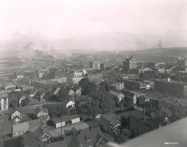
ca. 1920. Aerial view of stadium area of Tacoma in 1920
824 results directly related Exclude narrower terms
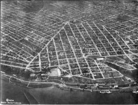
Part of General Photograph Collection
ca. 1920. Aerial view of stadium area of Tacoma in 1920
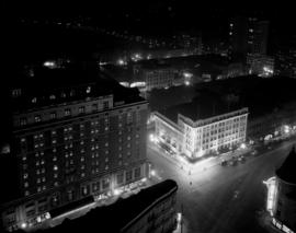
Part of Richards Studio Photographs
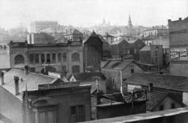
ca. 1920. View of 9th and Broadway taken from the roof of the Medical Arts Building. Night scene showing the Winthrop Hotel (773 Broadway), left, and an illuminated Pantages Theater (901 Broadway) building.
Aerial photographs; Hotel Winthrop (Tacoma); Hotels--Tacoma--1920-1930; Pantages Theater (Tacoma);
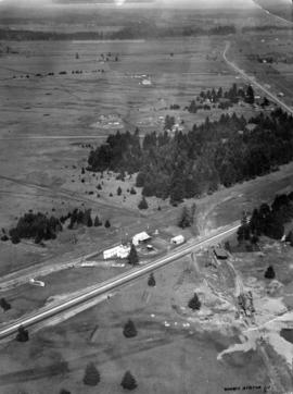
Part of General Photograph Collection
ca. 1920. Aerial view of Lakewood area, looking northwest, was taken by Barnes Aviation Co. in 1920. The building at right center is Lakeview School. The road at bottom of image is Pacific Highway with Northern Pacific Railroad tracks running next to the road. The street at left blending into Pacific is Lakeview Blvd. There are a few stores congregated near the bottom of the photograph.
Aerial photographs; Aerial views; Lakeview School (Lakewood); Streets--Lakewood; Railroad tracks--Lakewood;
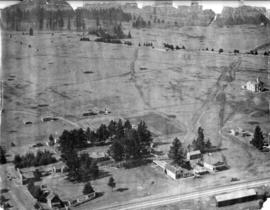
Part of General Photograph Collection
ca. 1920. Aerial view of Lakewood area, looking north, as photographed in 1920 by Barnes Aviation Co. The building at top center is Lakeview School. Road running along right top of image is Pacific Highway with Northern Pacific Railroad tracks next to road. Road going right to left across bottom is Old Highway 99 Road cutting across center of image and disappearing into the trees is the old Boundary Road (now 112th Street SW).
Aerial photographs; Aerial views; Lakeview School (Lakewood); Streets--Lakewood; Railroad tracks--Lakewood;
Part of Marvin Boland Photographs
This is how downtown Tacoma and surrounding areas appeared in the fall of 1919. In the foreground are houses and apartments west of Pacific Avenue. A few Tacoma landmarks are clearly visible in the distance: the Puget Sound National Bank building with spire and close to the 11th St. Bridge (now Murray Morgan Bridge), the Tacoma Building and the Perkins Building. Smoke billows from the various industrial plants and lumber mills in the Tideflats across the City (now Thea Foss) Waterway. G8.1-026;
Aerial views; Aerial photographs; Cityscapes; Puget Sound National Bank (Tacoma); Tacoma Building (Tacoma); Perkins Building (Tacoma); 11th Street Bridge (Tacoma);
Part of General Photograph Collection
ca. 1894. Business district of Tacoma (copy of original), circa 1894. Many of the streets surrounding Pacific Avenue in the 1890s, even then the heart of the city's financial district, were filled with a hodgepodge of wood framed buildings and more substantial brick structures. At the foreground are the Pioneer Paint Store, sellers of wallpaper, mouldings, paints, and glass and W.H. Robison's, where new and second hand goods could be purchased. The Freeman & Boggs livery stable, near left center, stood near the corner of 13th & Pacific. George A. Boggs, who was City Treasurer before going into private business, had been sent away to the state pen in Walla Walla after auditors found a $109,000 shortage in the city books. Also in the far right background is the steeple of the original St. Leo's Church near So. 11th & "D" St. S7.2, TPL-378 (Researched by Murray Morgan)
Commercial streets--Tacoma--1890-1900; Business districts--Tacoma--1890-1900; Freeman & Boggs Livery (Tacoma); Pioneer Paint Store (Tacoma); W.H. Robison (Tacoma);
Part of Richards Studio Photographs
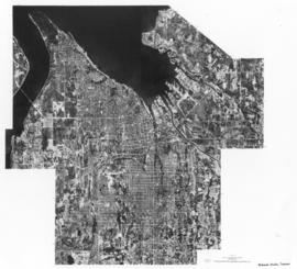
Copy of undated aerial photograph of the City of Tacoma as mosiaclike map was made for a sample book. TPL-8739
Aerial photographs; Maps;
Part of Richards Studio Photographs
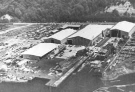
Copy of customer print. Aerial view of Tacoma Boatbuilding's plant alongside the Hylebos Waterway taken post-1969. The company's former location on the Sitcum Waterway had been destroyed by fire in 1968. They chose to build a new plant on Marine View Dr. on the Hylebos on 20 acres of land. Photograph ordered by Tacoma Boatbuilding.
Aerial views; Boat & ship industry--Tacoma--1970-1980; Tacoma Boat Building Co., Inc. (Tacoma); Hylebos Waterway (Tacoma); Logs;
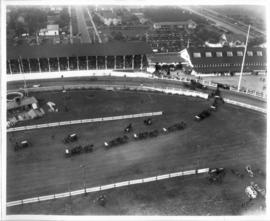
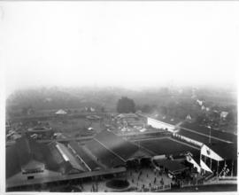
Part of Washington State Fair Collection
Aerial view of full Grandstand, wagon teams parading around interior.
Part of General Photograph Collection
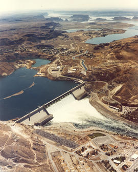
Part of Richards Studio Photographs
Undated color copy of photograph from the 1973 Richards stock footage. Aerial view of the Grand Coulee Dam and surrounding area. The dam is in the center with Lake Roosevelt behind. The Grand Coulee is a large hydroelectric dam located on the Columbia River.
Aerial views; Dams--Grand Coulee;
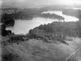
Part of General Photograph Collection
Lake Steilacoom - from the north end looking south. This undated aerial view of Lake Steilacoom was taken by the Barnes Aviation Co. A bridge is visible on the upper right connecting Interlaaken Dr. S.W. to Bridge Road on the west side of the lake. The road on the lower right corner is probably Lake Steilacoom Dr.
Aerial views; Aerial photographs; Lake Steilacoom (Wash.);
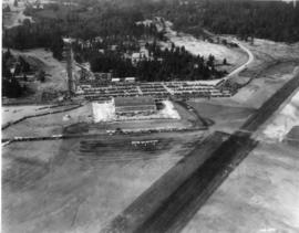
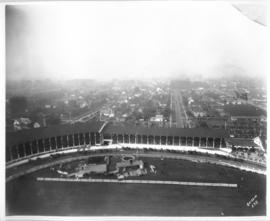
Part of Washington State Fair Collection
Aerial photo of grounds showing midway and barns, Grandstand at far right.
Part of Washington State Fair Collection
Aerial photo of Grandstand full of spectators.