Aerial Photography

Taxonomy

Code

Scope note(s)

Source note(s)

Display note(s)

Hierarchical terms

Aerial Photography

Equivalent terms

Aerial Photography

Associated terms

Aerial Photography

824 Collections results for Aerial Photography

824 results directly related Exclude narrower terms

D160915-10C

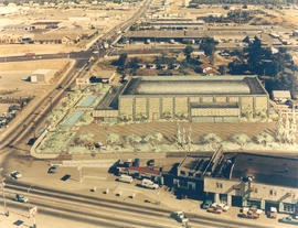
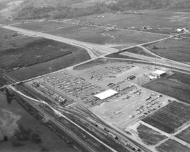
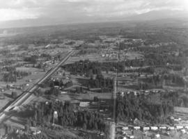
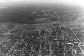
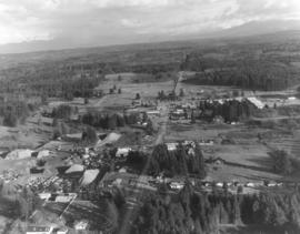
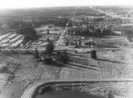
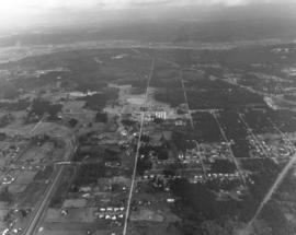
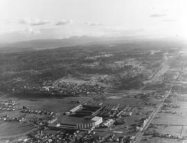
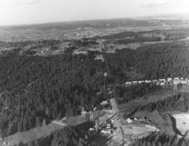
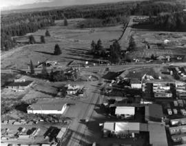
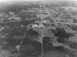
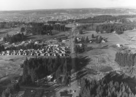
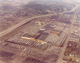
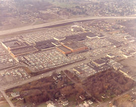
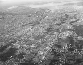
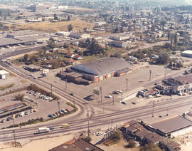
View from air of the Tacoma Sports Arena (formerly known as the Tacoma Ice Palace), 3801 South Union Avenue. Ben's Truck Parts had taken possession of the 25-year-old building on September 20, 1971. Originally built as an ice skating facility for $305,000, it was the home of the Pacific Coast League Tacoma Rockets hockey team for several years. Later usage of the Arena expanded to include live boxing events, motorcycle racing, Roller Derby, pro wrestling and dances. It was sold to Ben's Truck Parts for $175,000. Other structures of note in the above photograph include the Post Office's Terminal Annex on Warner St. and the Tacoma Mall Shopping Center at upper left corner. Color photograph ordered by Ben's Truck Parts. (TNT 9-3-71, p. 1 - article)


Aerial views; Tacoma Sports Arena (Tacoma); Tacoma Ice Palace (Tacoma); Ben's Truck Parts (Tacoma); Tacoma Mall Shopping Center (Tacoma);

C160915-1C

ca. 1971. Aerial view of former Tacoma Sports Arena with artist's rendering of possible architectural changes. Ben's Truck Parts had purchased the Tacoma Sports Arena (known prior as the Tacoma Ice Palace) on September 3, 1971. The company had commissioned the Richards Studio to take several aerial photographs of the Arena and vicinity. This aerial view shows possible architectural changes to the building and site with shimmering pools facing So. 38th St. and a profusion of trees and shrubs added. The exterior of the building would also change with walls apparently extended and a changed roofline. The location was easily accessible by traveling on So. 38th St. (now one of the city's busiest streets due to the close proximity to the Tacoma Mall), South Tacoma Way, and from the north, Union Ave. Color photograph ordered by Ben's Truck Parts.


Aerial views; Renderings; Tacoma Sports Arena (Tacoma); Tacoma Ice Palace (Tacoma);

D161273-30

This is possibly Thun Field, just south of the City of Puyallup in the South Hill neighborhood. The air field appears to be hemmed in by tall firs. Photograph taken on January 2, 1972; ordered by Puget Sound National Bank.


Aerial views; Airports;

D161273-12

One of a series of photographs taken by air on January 2, 1972, of the Puyallup-area neighborhoods of 112th & Meridian and vicinity. Tall evergreens blanket the area with a few homes carved out of the forests. Photograph ordered by Puget Sound National Bank.


Aerial views; Neighborhoods--Puyallup--1970-1980;

D161273-11

A Richards Studio photographer flew over the vicinity of 112th & Meridian on a clear January day in 1972 to take a series of photographs of this Puyallup-area neighborhood. Photograph ordered by Puget Sound National Bank.


Aerial views; Neighborhoods--Puyallup--1970-1980;

D161890-3

Aerial view of Kent-based Convoy Co. taken on May 1, 1972. Massive parking lot with hundreds of cars, easy access to major roadways. Railroad cars parked next to facility, many loaded with automobiles. Convoy Co. was located in Kent at 27430 - So. 72nd. Photograph ordered by the Convoy Co.


Aerial views; Convoy Co. (Kent); Automobiles--Kent;

D161273-19

Another in a series of photographs taken by air on January 2, 1972, of the Meridian South & 112th St. neighborhoods. The landscape would change in the following years as the area started to expand. Photograph ordered by Puget Sound National Bank.


Aerial views; Neighborhoods--Puyallup--1970-1980;

D161273-26

View by air of the area around 112th & Meridian near Puyallup. This was taken on January 2, 1972, on behalf of Puget Sound National Bank.


Aerial views; Neighborhoods--Puyallup--1970-1980;

D161273-7

This is an aerial of roughly the future location of the South Hill Mall area in January of 1972. Running vertically in the center of the photograph is 112th St. Meridian is the street that intersects 112th. Other than the cluster of homes on the left, much of the area is still very rural and wooded. Photograph ordered by Puget Sound National Bank.


Aerial views; Neighborhoods--Puyallup--1970-1980;

D161273-16

Aerial view of Puyallup Valley taken on January 2, 1972. This is roughly around the Meridian South vicinity; nestled among tall firs is a water tower visible at bottom of photograph. Photograph ordered by Puget Sound National Bank.


Aerial views; Neighborhoods--Puyallup--1970-1980; Water towers--Puyallup;

D161273-13

Aerial view of the Puyallup neighborhoods taken in January of 1972; the Western Washington Fairgrounds are located at Meridian South and 9th Ave. S.W. near center-right. Acres of trees at upper left-center. Photograph ordered by Puget Sound National Bank.


Aerial views; Neighborhoods--Puyallup--1970-1980; Western Washington Fair (Puyallup);

D161273-15

This aerial view of the Puyallup neighborhoods near 112th & Meridian was taken by the Richards Studio on January 2, 1972, on behalf of Puget Sound National Bank. Sand and gravel pit on the left; sprinkling of homes and businesses nearby.


Aerial views; Neighborhoods--Puyallup--1970-1980;

D161273-2

Another in a series of aerials of the area around 112th & Meridian in early 1972. In the late 1980s, the South Hill Mall would be built about this location. Photograph ordered by Puget Sound National Bank.


Aerial views; Neighborhoods--Puyallup--1970-1980;

D161273-24

This is what the 112th & Meridian area looked like in early 1972. The South Hill Mall would be built 16 years later on Meridian. What is noticeable is the large amount of woods and relatively few homes. Aerial photograph ordered by Puget Sound National Bank.


Aerial views; Neighborhoods--Puyallup--1970-1980;

D161273-5

The 112th & Meridian neighborhoods as seen by air in January of 1972. At that time there was an abundance of wooded acreage and not many homes. Photograph ordered by Puget Sound National Bank.


Aerial views; Neighborhoods--Puyallup--1970-1980;

D161273-20

Closer view of Puyallup neighborhood about 9th Ave. S.W. and Meridian South with Western Washington Fairgrounds in lower center. This photograph, one of a series, was taken on January 2, 1972, on behalf of Puget Sound National Bank.


Aerial views; Neighborhoods--Puyallup--1970-1980; Western Washington Fair (Puyallup);

D161273-18

A look by air at the 112th & Meridian South neighborhood in Puyallup in the early part of January, 1972. On the left appears to be a trailer court. Photograph ordered by Puget Sound National Bank.


Aerial views; Neighborhoods--Puyallup--1970-1980;

D161273-9

Wooded terrain in the neighborhood of 112th & Meridian. This view was taken by air on January 2, 1972, on behalf of Puget Sound National Bank.


Aerial views; Neighborhoods--Puyallup--1970-1980;

D161273-8

Aerial view in January of 1972 of "Willows Corner," about 112th & Meridian St. Building labeled "Flea Mart," on the right side, was the former Willows Tavern/The Willows. Builder J.J. Mabbott was responsible for the "pavilion" built near Puyallup in 1927. The area around 112th & Meridian would be greatly developed in the future, with the South Hill Mall being constructed in 1988. Photograph ordered by Puget Sound National Bank.


Aerial views; Neighborhoods--Puyallup--1970-1980; Willows (Puyallup);

D161273-27

Aerial view of relatively unpopulated 112th & Meridian area, showing location of the future South Hill Mall. Abundance of trees cover the land, much of which was later developed. Hwy. 512 is curving road parallel to 112th. Photograph ordered by Puget Sound National Bank.


Aerial views; Neighborhoods--Puyallup--1970-1980;

D161273-4

Aerial view of the 112th & Meridian neighborhood in January of 1972. Much of this land has now been developed, particularly since the construction of the South Hill Mall in 1988. Photograph ordered by Puget Sound National Bank.


Aerial views; Neighborhoods--Puyallup--1970-1980;

D162638-10C

This is the Kaiser Aluminum plant in the tideflats as seen by air during the fall of 1972. The 500-foot smokestack was built in 1968 during plant expansion. Photograph taken on speculation.


Aerial views; Kaiser Aluminum & Chemical Corp. (Tacoma); Aluminum industry--Tacoma--1970-1980; Smokestacks--Tacoma;

D162638-2C

Smoke pours from the 500-foot smokestack at the Kaiser Aluminum plant, 3400 Taylor Way, on October 12, 1972. The company had undergone expansion in the late 1960s and built a new aluminum rod mill and second aluminum dome in addition to the smokestack. Kaiser Aluminum would permanently close in 2002 and the smokestack demolished four years later.


Aerial views; Kaiser Aluminum & Chemical Corp. (Tacoma); Aluminum industry--Tacoma--1970-1980; Smokestacks--Tacoma;

C162245-1

Copy of customer print. Aerial view of Tacoma Boatbuilding's plant alongside the Hylebos Waterway taken post-1969. The company's former location on the Sitcum Waterway had been destroyed by fire in 1968. They chose to build a new plant on Marine View Dr. on the Hylebos on 20 acres of land. Photograph ordered by Tacoma Boatbuilding.


Aerial views; Boat & ship industry--Tacoma--1970-1980; Tacoma Boat Building Co., Inc. (Tacoma); Hylebos Waterway (Tacoma); Logs;

C162499-1

ca. 1972. Copy of customer print, ordered by law firm of Murray, Scott & McGavick on October 16, 1972. This is an aerial of the Gig Harbor area with various streets and company names written in. It appears that future construction of on and off-ramps and an overpass will impact housing and businesses already present. This is in the vicinity of Wollochet Gig Harbor Road.


Aerial views; Maps;

D153511-2

Downtown and freeway aerial view of February 13, 1968, on behalf of Puget Sound National Bank. I-5 is lower center, running horizontally. Six more ramps at the Pacific Ave. interchange and part of the 38th St. interchange (not shown) would be opened on 2-14-68. Wavy line in center is Hwy. 7. Pacific Ave. is long vertical road near right side; Puget Sound Hospital is next to Pacific Ave. on its right. Tacoma Dome will be constructed in the future in the neighborhood at the lower left corner. (TNT 2-11-68, C-19)


Aerial photographs; Cityscapes; Express highways--Tacoma--1960-1970; Puget Sound Hospital (Tacoma);

D153511-17

February 13, 1968, aerial view of 112th St. in Puyallup taken on behalf of Puget Sound National Bank. 112th St. had a mixture of homes with large lots and business development. New construction is occurring in lower center of photograph with large building's walls partially in place.


Aerial photographs; Neighborhoods--Puyallup;

D153156-8C

Aerial photograph of Northgate Shopping Center. Anchored by the Bon Marche and J.C. Penney stores, the Northgate Mall was the first enclosed shopping center in Seattle. Built in 1950, it was located five miles north of Seattle's downtown district. Anticipating growth in neighborhoods outside the downtown area, developers strategically placed the large shopping center between I-5 and 5th Ave. NE, allowing easy access from major roadways. Like the similarly designed Tacoma Mall, Northgate provided acres of free parking for its customers who could enjoy the enclosed, climate-controlled shopping center. Photograph ordered by Bell & Stanton, New York City.


Aerial photographs; Bon Marche (Seattle); Department stores--Seattle--1960-1970; J.C. Penney Co. (Seattle); Northgate Mall (Seattle); Shopping centers--Seattle--1960-1970; Express highways--Seattle--1960-1970;

D153156-4C

Aerial view of Northgate Shopping Center with focus on the red-tinted, multi-stored Bon Marche. Like the Tacoma Mall, the Northgate Mall was located next to the freeway, allowing easy access to the shopping center. It was approximately five miles north of downtown Seattle. Built in 1950, it was Seattle's first enclosed mall. The Northgate Mall offered acres of free parking and as the above December 23, 1967, photograph indicates, thousands were inside trying to finish up Christmas shopping. Photograph ordered by Bell & Stanton, New York City.


Aerial photographs; Bon Marche (Seattle); Department stores--Seattle--1960-1970; Northgate Mall (Seattle); Shopping centers--Seattle--1960-1970; Express highways--Seattle--1960-1970;

D153511-4

Aerial view looking downtown and including Tideflats on February 13, 1968, as requested by Puget Sound National Bank. Point Defiance is toward upper left. City's population is massed toward the left side of photograph; lower and right center are more sparsely occupied.


Aerial photographs; Cityscapes;

Results 121 to 150 of 824