Aerial Photography

Taxonomy

Code

Scope note(s)

Source note(s)

Display note(s)

Hierarchical terms

Aerial Photography

Equivalent terms

Aerial Photography

Associated terms

Aerial Photography

824 Collections results for Aerial Photography

824 results directly related Exclude narrower terms

C153566-1

Copy of customer copy. Aerial view of SR410, Puyallup to Sumner, with major state routes and roads clearly marked, ca. January, 1968. Visible are SR 161, 512, 167 and 410. Photograph ordered by Ward Smith, Inc., on February 20, 1968.


Aerial photographs; Express highways--Wash.;

C153566-3

Copy of customer's print. Photograph by air of SR 512 in Puyallup dated December, 1967. Major streets in Puyallup including 10th St. SE, Main Ave., Pioneer and Milwaukee, are clearly labeled as well as SR410 and directions to neighboring cities of Tacoma, Sumner and Parkland. The proposed Puyallup Valley freeway's effect on Puyallup is shown in the above mockup by the State Department of Highways. The system should be operable by late 1970. It was expected to cost $16 million dollars. Photograph ordered by Ward Smith, Inc., on February 20, 1968. (TNT 3-26-68, p. 8)


Aerial photographs; Express highways--Wash.;

D154000-270

Encompassing view of the downtown Tacoma business district as seen by air on September 4, 1968. In the far left background is the County-City Building with Central School a short distance away. In the foreground are the Greyhound Bus Terminal, Puget Sound National Bank and the Washington Building (from left). The Tacoma Building and the Perkins Building flank the 11th Street (now Murray Morgan) Bridge.


Aerial views; Aerial photographs; Business districts--Tacoma--1960-1970; Greyhound Bus Terminal (Tacoma); Puget Sound National Bank (Tacoma); Washington Building (Tacoma); County-City Building (Tacoma); Central School (Tacoma);

D154000-266C

ca. 1968. 1968 Richards stock footage. City Center. View by air on a sunny day in 1968 of Tacoma's City Center. This is in the vicinity of 12th & Pacific Ave. There is a large cleared area ready for construction down the street from the Puget Sound National Bank and National Bank of Washington. Other notable sights include the 11th Street Bridge crossing the City (now Thea Foss) Waterway, the Tacoma and Perkins Bldgs. near the entrance to the bridge, the Washington Building with red neon "Bank of California" sign, Peoples department store, and Rust Building.


Aerial views; Commercial streets--Tacoma--1960-1970; Puget Sound National Bank (Tacoma); National Bank of Washington (Tacoma); City Waterway (Tacoma); 11th Street Bridge (Tacoma); Tacoma Building (Tacoma); Perkins Building (Tacoma); Peoples (Tacoma);

D154000-271

This was the aerial view of Tacoma in September of 1968 looking down South 11th Street towards the Tideflats. At that time South 11th St. was a one-way street. At the bottom edge of the photograph South 11th intersects with Tacoma Avenue South. The roof of the Tacoma Public Library is at the bottom right; the flag on the grass to the left is on the County-City Building's lawn. The new building, under construction at the corner of 11th and Tacoma Ave. South, will be the State Savings & Loan Association building at 955 Tacoma Avenue South. It is across 11th from Siri's Restaurant (later to be Red Kelly's). Rhodes department store is down the hill on the left side; the Puget Sound National Bank's spire is on the right, closer to the waterfront.


Aerial views; Commercial streets--Tacoma--1960-1970; Puget Sound National Bank (Tacoma); Rhodes Brothers Department Store (Tacoma); Siri's Restaurant (Tacoma);

D154000-28C

1968 Richards stock footage. Colorful aerial view of downtown Tacoma business district and 11th St. Bridge crossing the City (now Thea Foss) Waterway, taken on February 13, 1968. Stradling 11th St. near the bridge are the Tacoma Bldg. and Perkins Bldg. To the right is the Art-Deco styled Medical Arts Bldg., 747 Market St. County-City Building, near 11th & Tacoma Ave. So., is center-left. Woods are part of Wright Park.


Aerial views; 11th Street Bridge (Tacoma); Tacoma Building (Tacoma); Perkins Building (Tacoma); Medical Arts Building (Tacoma); County-City Building (Tacoma); Commercial streets--Tacoma--1960-1970; Wright Park (Tacoma);

D154000-268

Closer view of the downtown business district as seen by air on September 4, 1968. Facing Pacific Ave. is the Puget Sound National Bank Bldg. with its familiar spire. The empty lot across it would soon be home to a 300+-spot parking lot. Behind the bank is the Federal Building (1102 A Street) where the federal courts were located (until 1992) and the Main branch of the U.S. Postal Service. The Rust Building (950 Pacific) and the 17-story Washington Building (1019 Pacific) are less than a block away. In the far background, near top of the photograph, are the County-City Building (930 Tacoma Ave. So.) and Central School (601 So. 8th St.)


Aerial views; Aerial photographs; Business districts--Tacoma--1960-1970; Puget Sound National Bank (Tacoma); Washington Building (Tacoma); Federal Building (Tacoma); County-City Building (Tacoma); Central School (Tacoma);

D154000-274

1968 Richards stock aerial footage. The downtown area was still considered the city's center of commercial business. Major banks and stores were in close proximity to the industrial Tideflats with easy access via the 11th Street Bridge. This September, 1968, view shows several easily identifiable landmarks: the U-shaped with tower Central School, the winged-shaped County-City Building, and Tacoma Public Library all on Tacoma Ave. approximately in the center of the photograph. The Art-Deco Medical Arts Building on 7th & Market is on left center. Puget Sound National Bank's unique spire is at 11th & Pacific, relatively close to the City (now Thea Foss) Waterway.


Aerial views; Commercial streets--Tacoma--1960-1970; Central School (Tacoma); County-City Building (Tacoma); Tacoma Public Library (Tacoma); Medical Arts Building (Tacoma); Puget Sound National Bank (Tacoma); 11th Street Bridge (Tacoma);

D154000-86

1968 Richards aerial stock footage. Stadium High School, portion of Stadium Bowl. Stadium High School, which is currently undergoing extensive remodeling in 2005, resembles a French chateau. It has a magnificent view of Commencement Bay. Built but never completed as a hotel, it converted to a high school in 1905. A small portion of Stadium Bowl, including rows of bleachers, is visible lower left corner. Originally the bowl had a seating capacity of nearly 24,000; however, after numerous mudslides, it has a reduced modern capacity of 15,000. TPL-10144


Aerial views; Stadium High School (Tacoma); Public schools--Tacoma--1960-1970; Stadium Bowl (Tacoma);

D154000-29C

1968 Richards Stock footage. Closer look at the 11th, Yakima and Tacoma Ave. business districts looking eastward toward the city's waterfront on February 13, 1968. Tacoma Vocational-Technical Institute's 317-foot radio tower is at lower foreground; across the street is the Washington State Armory. Block downhill is the County-City Building with enormous wings on left, Tacoma Public Library with round Carnegie Library section on right. Industrial Tideflats towards top of photograph including various waterways and St. Regis Paper Co.


Aerial views; Commercial streets--Tacoma--1960-1970; County-City Building (Tacoma); Tacoma Public Library (Tacoma); State Armory (Tacoma); Tacoma Vocational School (Tacoma); Towers--Tacoma;

D154000-272

Aerial view of downtown Tacoma taken on September 4, 1968. The 11th St. Bridge spans the City (Thea Foss) Waterway to connect the business district to the more industrial Tideflats. Many of Tacoma's landmark buildings are in sight including the spire of the Puget Sound National Bank Bldg., the Tacoma Building, the Washington Building, the Rust Building and Peoples department store. The large vacant space on Pacific Ave. was slated for the Park Plaza South parking garage.


Aerial views; Aerial photographs; Business districts--Tacoma--1960-1970; Puget Sound National Bank (Tacoma); 11th Street Bridge (Tacoma); Tacoma Building (Tacoma); Washington Building (Tacoma); Rust Building (Tacoma); City Waterway (Tacoma);

D154000-275

1968 Richards stock aerial footage. Closer look at primary businesses and institutions in Tacoma's commercial downtown area. Centered is the expansive County-City Building which replaced Old City Hall in 1959. On the left side is Central School's Gothic styled eight-storied building. On the right side of the County-City Building is the Tacoma Public Library. The Washington State Armory is behind the parking lot of the County-City Building. Across 11th Street from the Armory is the Tacoma Vocational-Technical School (to be renamed L.H. Bates Vocational-Technical in 1969). The Hilltop neighborhood is closer to the bottom of the photograph. 11th Street Bridge at the top of the photograph leads into the Tacoma industrial Tideflats as it provides access over the City (now Thea Foss) Waterway. Primary office buildings and banks visible near the water are the Perkins Tacoma, and Washington buildings and Puget Sound National Bank.


Aerial views; Commercial streets--Tacoma--1960-1970; County-City Building (Tacoma); Central School (Tacoma); Tacoma Public Library (Tacoma); State Armory (Tacoma); Perkins Building (Tacoma); Tacoma Building (Tacoma); City Waterway (Tacoma);

D154000-33

1968 Richards Stock aerial footage. Wright Park. Located near Tacoma's downtown business district, the park with its shady trees and meandering paths provided a tranquil setting for urban dwellers. Lawn bowlers took advantage of the smooth manicured playing field and in the winter, skaters would venture onto the park's frozen ponds. The glassed-in Seymour Conservatory, still in use in 2005, was filled with exotic blossoms as well as native Northwest foliage. The Greek ionic-styled First Church of Christ, Scientist, located on Division directly across from the park, was built in 1911. The City Waterway (now Thea Foss) can be seen on the upper left of the picture with part of the industrial Tideflats in view.


Aerial views; Wright Park (Tacoma); First Church of Christ, Scientist (Tacoma); City Waterway (Tacoma);

D155022-3

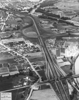
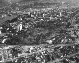
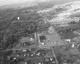
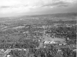
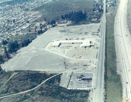
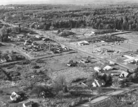
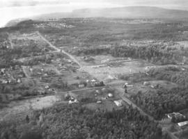
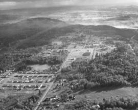
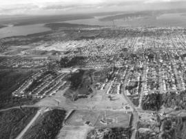
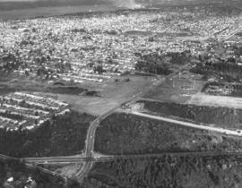
Aerials of the Northeast Tacoma - Federal Way area taken on October 30, 1968, on behalf of Puget Sound National Bank. Development is occurring in this location although there is still much forested land. Looking due north, attention is drawn to the long vertical roadway of 21st Ave. S.W. which is in Federal Way. As the road curves toward the left, it becomes 29th St. N.E. in Tacoma. When 21st Ave. splits off to the right, it becomes 356th St. S.W., again in Federal Way. A small shopping center, anchored by National Auto Parts (black roof), faces 21st Ave. S.W. Mosier's Enco Service Station, 35455 21st Ave. S.W., is directly across Blaser's Richfield Service Station on S.W. 356th St. A large water tower emerges from the woods in the upper left section of the picture.


Aerial views; Aerial photographs; Neighborhoods--Federal Way--1960-1970; Neighborhoods--Tacoma--1960-1970; National Auto Parts (Federal Way); Mosier's Enco Service Station (Federal Way); Blaser's Richfield Service Station (Federal Way); Water towers;

D155022-9

This aerial view of the area looking east on 29th St. N.E. was taken in late October of 1968. In the immediate foreground is the Northeast Tacoma Elementary School, 5412 - 29th St. N.E., designed by the architectural firm of Heath, Gove & Bell and built in 1919 with additions following in 1959 and 1973. The black rooftops of the small shopping center containing the National Auto Parts and Walkley's Pharmacy can be seen mid-center of the photograph. Photograph ordered by Puget Sound National Bank.


Aerial views; Aerial photographs; Neighborhoods--Tacoma--1960-1970; Neighborhoods--Federal Way--1960-1970; Northeast Tacoma School (Tacoma);

D155600-68C

1969 Richards stock footage. Looking quite a bit different in May of 1969, the area around So. 72nd and the freeway was starting to be developed commercially. The new Rodeway Inn of America was under construction at 6802 So. Sprague, close to the freeway. Travelers could easily exit the freeway to find comfortable lodgings. A Standard Oil station was conveniently located nearby. The 130-unit luxury motor hotel opened in early November, 1969, with a 90-unit addition planned. (TNT 11-2-69, D-14)


Aerial views; Building construction--Tacoma--1960-1970; Rodeway Inn of America (Tacoma); Motels--Tacoma--1960-1970; Automobile service stations--Tacoma--1960-1970;

D155600-450C

ca. 1969. 1969 Richards stock footage. Aerial view of Eastern Oil operations in 1969. Storage tanks dot the landscape of the large site on Marine View Dr. N.E. facing the Hylebos Waterway. Although tentatively identified as "Eastern Oil," it is possible that this is actually the Sound Refining Co., located on the northwest edge of the Tideflats. Sound Refining began operations in 1967 as a crude oil refinery.


Aerial views; Eastern Oil Co. (Tacoma); Storage tanks--Tacoma;

D155022-10

Aerial views of Northeast Tacoma/Federal Way. Small section of businesses on right side includes a Richfield service station and an automotive parts store with large parking lot. This particular October, 1968, photograph focuses on a small shopping center which is actually on 21st Ave. S.W. in Federal Way. The businesses included National Auto Parts, Walkley's Pharmacy, Mosier's Enco Service Station and where 21st Ave. turns into S.W. 356th St., Blaser's Richfield Service Station. Photograph ordered by Puget Sound National Bank probably for bank expansion.


Aerial views; Aerial photographs; Neighborhoods--Tacoma--1960-1970; Neighborhoods--Federal Way--1960-1970; National Auto Parts (Federal Way); Mosier's Enco Service Station (Federal Way); Blaser's Richfield Service Station (Federal Way);

D155022-11

This view of northeast Tacoma near the border with King County dates from October of 1968. The road cutting through the image from top left to bottom right is 29th Street N.E. Northeast Tacoma Elementary School at 5412 29th St. N.E. is just visible near the upper left corner. Much of the area is still heavily wooded, but a small, new shopping center, featuring National Auto Parts, Walkley's Pharmacy and Mosier's Enco Service Station, is located mid-center on 21st Ave. S.W. in Federal Way.


Aerial views; Aerial photographs; Neighborhoods--Tacoma--1960-1970; Neighborhoods--Federal Way--1960-1970; Northeast Tacoma School (Tacoma); National Auto Parts (Federal Way); Mosier's Enco Service Station (Federal Way);

D155600-75C

1969 Richards stock footage. Closer look by air at the 7-month-old Aladdin Apartments, located in the city's south end at 2112 So. 90th St. The upscale apartment complex, built by developer Oscar Hokold, was opened in September of 1968. Residents of the one and two bedroom units enjoyed such amenities as spacious bedrooms, wall-to-wall carpeting, soundproofing and dishwashers. All had views of the landscaped greens and swimming pool area.


Aerial views; Aladdin Apartments (Tacoma); Housing developments--Tacoma--1960-1970;

D155600-440C

1969 Richards stock footage. Color aerial view of Export Pacific Co. By 1969, Export Pacific's address had changed from 900 Milwaukee Way to 1942 E. 11th, next door to the Brown & Haley Distribution Division. Still headed by Chauncey L. Griggs, the firm remained in the lumber export business while sharing the address with the Export Pacific Grain Co.


Aerial views; Export Pacific Co. (Tacoma); Shipping--Tacoma--1960-1970;

D155022-A

Aerial views of Northeast Tacoma/Federal Way neighborhoods requested by Puget Sound National Bank. The area was still heavily wooded in October of 1968. Puget Sound National Bank may have been photographing Northeast Tacoma and adjoining Federal Way in anticipation of opening a new branch in the area. In mid-center of the photograph is a small shopping center that held the National Auto Parts store, Walkley's Pharmacy, and Mosier's Enco Service Station. It was located on 21st Ave. S.W. in Federal Way. 21st Ave. S.W. turns in one direction into 29th St. N.E. which is in Tacoma; when it turns the other way it develops into S.W. 356th St. in Federal Way.


Aerial views; Aerial photographs; Neighborhoods--Tacoma--1960-1970; Neighborhoods--Federal Way--1960-1970; National Auto Parts (Federal Way); Mosier's Enco Service Station (Federal Way);

D155600-72C

1969 Richards stock footage. Aerial view of the Aladdin Apartments, 2112 So. 90th St., which were completed in 1968. Built by local developer Oscar Hokold, the units were all electric and rented for $135 and up. The Aladdin was centrally located, close to the freeway and mere minutes from the Tacoma Mall.


Aerial views; Aladdin Apartments (Tacoma); Housing developments--Tacoma--1960-1970;

D155600-360C

1969 Richards stock footage. Aerial view of No. 4th & D neighborhood during the summer of 1969. The Washington State Historical Society building on Stadium Way is the neo-classical structure next to Stadium Bowl. Many homes with Commencement Bay views were built in this neighborhood. A boat is seen streaming toward shore; this is believed to be the snagboat, the W.T. Preston, which was the last working sternwheeler on Puget Sound.


Aerial views; Boats--Tacoma--1960-1970; Neighborhoods--Tacoma--1960-1970; Washington State Historical Building (Tacoma); Stadium Bowl (Tacoma);

D155600-443C

ca. 1969. 1969 Richards stock footage. Viewed by air in 1969, automobiles look like toys piled in heaps at the General Metals of Tacoma scrap yard on Marine View Dr. N.E. A giant crane is positioned on a pier ready to hoist the junked vehicles. General Metals had moved to a 20-acre site on the Hylebos Waterway about 1967. TPL-5902


Aerial views; General Metals of Tacoma Inc. (Tacoma); Junkyards--Tacoma; Hoisting machinery; Hylebos Waterway (Tacoma);

D155600-445C

ca. 1969. 1969 Richards stock footage. Aerial look at the Glacier Sand & Gravel Co. operations in 1969. Several cone-shaped mounds of sand and/or gravel are positioned in a semi-circle at the Glacier Sand & Gravel site on Taylor Way. The sand and gravel could be delivered to the plant by either barge as the site fronted the Hylebos Waterway or by railroad cars and consequently transported out the same way.


Aerial views; Glacier Sand & Gravel Co. (Tacoma); Building materials industry--Tacoma--1960-1970; Hylebos Waterway (Tacoma);

D155600-22C

ca. 1969. 1969 Richards stock footage. Aerial view of large Tudor-styled home with landscaped grounds taken in 1969. Another view of the same property is found at D155600, image 21c. The unidentified home is nestled among large firs. It is believed to be located in the Gravelly Lake Drive area of Lakewood. Although not shown in this particular photograph, the house would have a magnificent view of a pristine lake.


Aerial views; Houses--Lakewood;

D155600-62

This aerial view of downtown Tacoma from May of 1969 centers on the block bordered by South 12th & 13th, and Pacific & A Streets; this block was the future home of the Bank of Washington Plaza. Most of the buildings on the block have been demolished. The empty lot across Pacific (toward the bottom of the photo) will be the site of the Park Plaza South Parking Garage, 1137 Commerce Street. The parking garage was built in 1970. The two tall chimneys, top center, belong to the Tacoma Steam Plant No. 1 (to the left) and the Consumer Central Heating Company. The bridge at the right crossing the the City (now Thea Foss) Waterway is the old 15th Street Railroad Bridge. (TNT 11-20-68, p. 1)


Aerial views; National Bank of Washington (Tacoma); Banks--Tacoma; Building construction--Tacoma--1960-1970; City Waterway (Tacoma);

D155048-4

This aerial view of Tacoma looking north from South 19th Street was taken in November of 1968. The baseball field (lower center) is Heidelberg Field; the cleared land across 19th from the ball park is the future home of the Fred Meyer Department Store. ASARCO smelter's stack puffs a steady stream of smoke in upper center of photograph. Point Defiance is wooded area to the smelter's left. Photograph ordered by Morley Studios. TPL-3804


Aerial views; Neighborhoods--Tacoma--1960-1970; Heidelberg Field (Tacoma);

D155048-5

North end neighborhoods featuring So. 19th & Mason Sts., looking toward downtown and Tideflats. Heavily populated north end still had some sections of woods; nearly all would be eventually developed into businesses and residential housing. Ballpark in right-center is Heidelberg Field. Bare land across So. 19th from ballpark will be a shopping center eventually featuring a Fred Meyer store. So. 19th extends through the woods until it intersects with busy Hwy 16. New road is being constructed west of Heidelberg Field. Photograph ordered by Morley Studios.


Aerial views; Neighborhoods--Tacoma--1960-1970; Heidelberg Field (Tacoma);

Results 151 to 180 of 824