Aerial Photography

Taxonomy

Code

Scope note(s)

Source note(s)

Display note(s)

Hierarchical terms

Aerial Photography

Equivalent terms

Aerial Photography

Associated terms

Aerial Photography

824 Collections results for Aerial Photography

824 results directly related Exclude narrower terms

A102546-3

Aerial of the Port of Tacoma, taken from over Commencement Bay heading into the Port. Mount Rainier looms whitely in the background. Browns Point can be seen in the left foreground, with the fingers of the port and the inlets of waterway further back.


Aerial views; Port of Tacoma (Tacoma)--1950-1960;

A103462-1

Aerial photographs were taken on December 4, 1956, at the request of U.S. Oil & Refining Co. of the petroleum tank "farm" on the Tideflats heading toward town. The huge light-colored cylinders dot the landscape. U.S. Oil had broken ground in July, 1955, for a new 10-million dollar oil refinery on an 120 acre site in the Tideflats. TPL-5897


Aerial photographs; Storage tanks--Tacoma; US Oil & Refining Co. (Tacoma);

A104350-6

Construction at Fort Lewis remained strong in the mid-1950's as the military population continued to grow. February 12, 1957, aerial photographs show two company barracks and utilities structures being built at the south end of Gray Field. Donald M. Drake Co. of Portland, Oregon, apparently were involved in Contract #3706. Photograph ordered by the Donald M. Drake Co.


Aerial photographs; Building construction--Fort Lewis; Donald M. Drake Co. (Portland, Or.);

A104350-2

Aerial photographs of the south end of Gray Field on Fort Lewis were taken on February 12, 1957. Construction appears to be continuing on two company barracks and utilities building. Roads will have to be extended to meet the new quarters. Photograph ordered by Donald M. Drake Co., Portland, Oregon. TPL-10352


Aerial photographs; Building construction--Fort Lewis; Donald M. Drake Co. (Portland, Or.);

D105615-1

This aerial view of Tacoma's West End and the Tacoma Narrows Bridge was taken in March of 1957. 6th Avenue cuts upward through the center of the picture curving to the right as it feeds onto the Narrows Bridge. The road starting at the bottom right and running into 6th Ave. is Pearl Street, with the Tacoma Auto View Theater, 1202 North Pearl near the right edge. The buildings at the corner of 6th and Pearl are the early Highland Hills Shopping Center, 5915 6th Ave.. The bare land just above and to the right of the Auto View became the Highland Hills Golf Course.


Aerial photographs; Tacoma Narrows Bridge (Tacoma); Neighborhoods--Tacoma--1950-1960;

A107984-10

Aerial photographs of the Huntington Rubber Mills were taken on July 13, 1957. This is possibly the Seattle plant at 35 W. Lander. The business occupied a large chunk of land bordered by several roads. There were at least four separate buildings making up the plant. Photograph ordered by Huntington Rubber Mills.


Aerial photographs; Huntington Rubber Mills (Seattle); Industrial facilities--Seattle;

A108235-1

An aerial photograph of the Hooker Electrochemical plant in the Tideflats was taken on July 24, 1957, for possible order by the company. Storage tanks appear to be loaded on railroad cars on two parallel tracks. Hooker was the second chlor-alkali plant in the United States and the first caustic soda plant in the Pacific Northwest. This was apparently an aerial view of an area of Hooker Electrochemical Co. on Industrial Waterway.


Aerial photographs; Hooker Electrochemical Co. (Tacoma); Chemical industry--Tacoma--1950-1960;

D108639-2

Lakewood Center as pictured by air in August of 1957. Located near the busy streets of Bridgeport Way and Gravelly Lake Dr., the Lakewood Center was among the first of the nation's one-stop shopping centers. It underwent several expansions including a major addition in 1955 when the modified Colonial, shown above with an "open" triangular side, opened with fourteen new businesses. The shopping center was 15 minutes from downtown Tacoma, five minutes from McChord and ten from Fort Lewis. It provided an alternative shopping area for residents in the communities outside Tacoma city limits with the added attraction of more parking than in downtown Tacoma.


Aerial photographs; Lakewood Community Center (Lakewood); Shopping centers--Lakewood--1950-1960;

D108639-5

Aerial view of the Villa Plaza Shopping Center taken for its opening in August of 1957. One thing was clear: there was plenty of parking available for shoppers at Lakewood's newest shopping center, the Villa Plaza, and plenty of room for expansion if necessary. The Villa Plaza heavily advertised its free 4000-car parking lot and the convenience of many stores side-by-side including familiar names J.C. Penney's, Woolworth's and Rhodes Brothers. Acknowledging the buying power of suburbanites, these major department stores left their flagship operations downtown but garnered new shopping dollars by opening branches outside city limits. The Villa Plaza, like the older Lakewood Center, was closer to McChord and Fort Lewis than downtown.


Aerial views; Aerial photographs; Villa Plaza Shopping Center (Lakewood); Shopping centers--Lakewood--1950-1960; Parking lots--Lakewood;

D109420-7

Aerial photographs- U.S. Oil Refinery. Aerial photographs of the U.S. Oil refinery were taken on October 3, 1957. The petroleum "tank farm" was located on an 120 acre site in the Tideflats. The light colored round cylinders shown in the photograph are probably the storage tanks. The refinery would be close to both rail and water transport. Photograph ordered by U.S. Oil & Refining Co.


Aerial photographs; Storage tanks--Tacoma; US Oil & Refining Co. (Tacoma);

A111233-3

This aerial photograph of the St. Regis pulp mill looking toward Mt. Rainier was taken on behalf of Malcolm McGhie in December, 1957. The St. Regis plant was flanked by the Puyallup Waterway (L) and St. Paul Waterway (R) with the Middle Waterway to the extreme right. Smoke pours from the St. Regis plant facilities on a typical winter day; the plant employed multiple shifts so that operations could be conducted 24 hours a day, seven days a week. The multi-wall bag plant and kraft-pulp division are in the center of the photograph. The long narrow building is for kraft-pulp, adjoining the white-walled rectangular bag plant. The St. Paul & Tacoma Lumber Co. sawmill is in close proximity to the kraft pulp and paper mill. In August, 1957, St. Paul became an operating subsidiary of the St. Regis Paper Co. St. Paul had the largest retail lumber yard in the state of Washington. Its sawmill had furnished chips to St. Regis for a number of years, providing about 35% of the pulp mill's wood requirements. (TPL-5890, St. Regis Annual Report - 1957, p. 14-15)


Aerial photographs; St. Regis Paper Co. (Tacoma)--1950-1960; St. Paul & Tacoma Lumber Co. (Tacoma);

A111233-1

Aerial photographs of the Middle Waterway and the Tideflats area were taken on behalf of Malcolm McGhie in December, 1957. The St. Paul & Tacoma Lumber Co. facilities, sawmill, and log ponds are toward the center of the photograph. The St. Regis plants are, with smokestacks billowing, are near the top of the picture. Forty-five years later, the Tideflats landscape would be quite transformed. The City Waterway (now Thea Foss Waterway), although not in this picture, would no longer have docks, plywood mills, shipyards and warehouses crowding its sides. A 29.3 million dollar Museum of Glass and the adjoining Chihuly Bridge of Glass would be the first of millions of dollars of improvement to the area. TPL-5893


Aerial photographs; Middle Waterway (Tacoma); St. Paul & Tacoma Lumber Co. (Tacoma); St. Regis Paper Co. (Tacoma)--1950-1960;

D116584-10C

ca. 1958. Aerial view of newly built County-City Building, 930 Tacoma Avenue South, circa 1958, and surrounding neighborhood. The building would be dedicated in April of 1959. Directly behind its left wing is the venerable Pierce County Courthouse, 1012 South "G" St., soon to be demolished and ground transformed into parking for the County-City Building. At left lower corner is the Tacoma Public Library, 1102 Tacoma Avenue South.


Aerial views; Aerial photographs; County-City Building (Tacoma); Pierce County Courthouse (Tacoma); Tacoma Public Library (Tacoma); Streets--Tacoma--1950-1960; Commercial streets--Tacoma--1950-1960;

G9.1-085

ca. 1958. Aerial view of No. 30th Street and Ruston Way. The largest street running vertically in the photograph is No. 30th Street. The street running along side of the water is Ruston Way. Just below the bottom of the picture is the intersection with Starr Street. The next street (that crosses the railroad tracks) is McCarver. The businesses running along Ruston Way (from the bottom up) are the Ocean Fish Mart, the Top of the Ocean nightclub, a small office building, Tacoma Boat Mart and the Dickman Lumber Mill (the largest group of buildings.) TPL-8657


Aerial photographs--Tacoma--1950-1960; Ocean Fish Mart (Tacoma); Top of the Ocean (Tacoma); Dickman Lumber Mill (Tacoma);

D116584-8C

ca. 1958. Aerial view of the neighborhood around Tacoma Avenue South near the new County-City Building circa 1958. In the center is the County-City Building, with its two wings and tower at 930 Tacoma Avenue South, built to replace the deteriorating Pierce County Courthouse immediately to its rear. The Romanesque old Courthouse at 1012 South "G" would be demolished and the area used as a parking lot. At left center is the Tacoma Public Library, 1102 Tacoma Avenue South. The Central School, 601 South 8th, is at right center edge but McDonald's is yet to be built next door on Tacoma Avenue South.


Aerial views; Aerial photographs; Cityscapes--Tacoma--1950-1960; County-City Building (Tacoma); Pierce County Courthouse (Tacoma); Tacoma Public Library (Tacoma); Central School (Tacoma); Streets--Tacoma--1950-1960;

D116584-9C

ca. 1958. This aerial view is looking west with focus upon the newly built County-City Building at 930 Tacoma Avenue South, circa 1958. The venerable Pierce County Courthouse, directly behind one of the County-City Building wings, was in poor shape and after much discussion, it was decided to build a new structure to replace it. Site preparation and excavation began in 1955 but the building would not be completed until 1959. Also in view are the Tacoma Public Library, directly across the street at 1102 Tacoma Avenue South, and the State Armory at 715 South 11th, behind the Pierce County Courthouse.


Aerial views; Aerial photographs; County-City Building (Tacoma); Pierce County Courthouse (Tacoma); Tacoma Public Library (Tacoma); State Armory (Tacoma); Commercial streets--Tacoma--1950-1960; Streets--Tacoma--1950-1960;

C116284-1

ca. 1958. Copy of customer's print. An artist has placed his conceptualized drawing of the new regional shopping center, to be later called the Tacoma Mall, along with the future I-5 freeway over an aerial photograph of the South 38th St. area. Steele Street would lead into the shopping center from South 38th St. The Lincoln Heights housing development are the winding roads just off 38th St. The heavily wooded area near the Mall is presumably the Tacoma Cemetery and South Park. Allied Owners, Inc., had applied four times by August, 1958, for rezoning from a residential to regional shopping center district. They wanted to build a $20 million South Tacoma shopping headquarters, "Town Center," in an area surrounding South 43rd, South 48th & Pine Sts. and the freeway. Each time their request before the City Planning Commission had been denied. Photograph ordered by Allied Owners, Inc. (TNT 8-31-58, A-6)


Aerial photographs; Architectural drawings;

D111635-2

Additional aerial photographs of the Tideflats area were requested by Malcolm McGhie and taken on January 3, 1958. Earlier photographs were taken about a month prior. Dash Point can be spotted protruding into the bay on the right with Vashon Island at the top of the photograph. St. Paul & Tacoma Lumber Co., who in August, 1957, became a subsidiary of St. Regis Paper Co., can be clearly seen towards the middle of the photograph including its loaf-shaped buildings. Its sawmill had provided 35% of the pulp mill's wood requirements. St. Regis is adjacent to its new subsidiary and to the upper right. The City Waterway is the body of water to the extreme left; new developments, with the removal of warehouses, shipbuilding, and mills nearly 45 years later have changed its landscape and revitalized the area.


Aerial photographs; St. Paul & Tacoma Lumber Co. (Tacoma); St. Regis Paper Co. (Tacoma)--1950-1960;

D111635-1

This was how Tacoma's Tideflats appeared from the air on January 3, 1958. The area was crowded with pulp and paper mills, lumber yards, log ponds and warehouses. Tacoma's easy access to rail and water made the transport of industrial and wood products a simpler process. View of, left to right, the City, Middle, St. Paul and Puyallup Waterways. The St. Regis plant was located on the finger between the Puyallup and St. Paul waterways in the buildings with the "L" shape. The St. Paul & Tacoma Lumber sawmill and buildings were close by, at the rear of the waterway in the loaf shaped buildings. In August 1957, St. Paul became an operating subsidiary of the St. Regis Paper Co. Photograph ordered by Malcolm McGhie.


Aerial photographs; St. Regis Paper Co. (Tacoma)--1950-1960; St. Paul & Tacoma Lumber Co. (Tacoma);

A112205-11

Aerial photographs of South Fort Lewis were taken on January 26, 1958. The carefully laid out design appears symmetrical, with identical buildings and parking lots on both sides of the wide field. These may have been newly constructed buildings. The view taken from the air gives the appearance of a architectural model setup. Forested lands are abundant on the property; there is plenty of space for expansion. Photograph ordered by Donald L. Drake Co.


Aerial photographs; Building construction--Fort Lewis;

C112481-1

Copy of customer print. Aerial photographs of Seattle's Huntington Rubber Mills' facilities were taken in the spring of 1958. The smaller building in front may have been the office and the larger elongated buildings nestled close together, plant facilities. All three have semi-curved roofs. There were also two other buildings joined together to the left of the photograph. Photograph ordered by Huntington Rubber Mills.


Aerial photographs; Huntington Rubber Mills (Seattle);

A113586-1

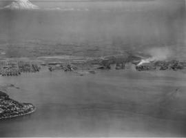
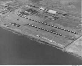
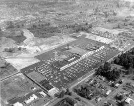
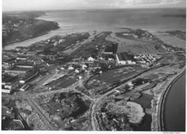
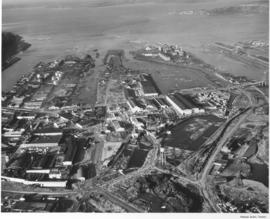
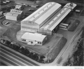
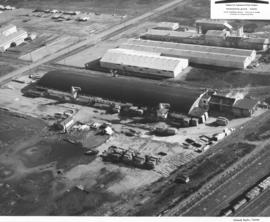
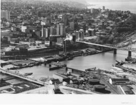
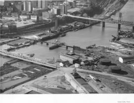
Woodlam, Inc., was a laminated wood products company located in the Tideflats at 1476 Thorne Rd. William Lindberg was listed as president in the 1959 City Directory. Woodlam was formerly known as Laminated Wood Products Co. and was owned by Arne Strom. Strom had opened the plant in February, 1957, and sold the facility to Lindberg in April, 1958. Woodlam, Inc., employed between 80-100 workers. Purchase of the plant involved eight acres of land, a 500 X 100 foot main plant, drying kilns and a suite of offices. Aerial photographs were taken on April 10, 1958, showing piles of plywood outside the large plant facilities. Railroad tracks close by meant easy rail access for the laminated products. Photograph ordered by Woodlam, Inc. (TNT 4-26-58, A-1)


Aerial photographs; Woodlam, Inc. (Tacoma);

A113921-5

This aerial view of Tacoma's commercial district was taken in April of 1958. Several log booms float at the south end of the Foss waterway just past the 15th St. Bridge. The tall smokestack near the center is the Dock St. steam plant. The other two bridges are the Railroad Bridge and the Murray Morgan Bridge. Several prominent buildings, including Old City Hall, Puget Sound National Bank, and the Washington Building, are visible. Among current landmarks that are missing: I-705, the Frank Russell Building, and the Columbia Bank Building. TPL-8467


Aerial photographs; Bridges--Tacoma--1950-1960; 11th Street Bridge (Tacoma); Logs;

A113921-4

Aerial photographs of the Puyallup River as it meanders through Tacoma were taken by Richards Studio on April 22, 1958. A close-up view of the three bridges over the river indicate that only the main bridge in the center had any traffic at the time the photograph was snapped. The bridge appears at a definite angle in this particular picture.


Aerial photographs; Bridges--Tacoma; Puyallup River (Wash.);

A113921-7

Aerial views of downtown Tacoma were taken on April 22, 1958. The busy commercial streets showcase many of the city's financial structures. Looking southeast in the center of the picture is Pacific Avenue with the Security Building (formerly Provident Building), the Ionic-columned Bank of California, Washington Building and Puget Sound National Bank, formerly the tallest building on the West Coast. The new Tacoma Building, Weyerhaeuser headquarters, and its predecessor are side-by-side on A Street, one street beyond, with the Perkins Building across the street.


Aerial photographs; Commercial streets--Tacoma--1950-1960; Security Building (Tacoma); Puget Sound National Bank (Tacoma); Bank of California National Association (Tacoma); Washington Building (Tacoma); Perkins Building (Tacoma);

A113921-8

Another view of the bridges crossing the Puyallup River was taken via air by Richards Studio on April 22, 1958. Water levels indicate that the river had not overflooded its borders. There are no buildings directly on the river's edge because of the flooding potential. The white or light gray colored bridge has been identified as the Eells St. bridge looking south. From above it appears to have an open geometric design; the curvature on top is reminiscent of a roller coaster track. It connected Pacific Highway and Fife to the left and Puyallup Ave. and Tacoma to the right. The other two bridges were railroad bridges and still there some fifty years later. (Additional identification provided by a reader)


Aerial photographs; Bridges--Tacoma--1950-1960; Railroad bridges--Tacoma; Eells St. State Highway Bridge (Tacoma); Puyallup River (Wash.);

A113921-2

Five bridges span the channelized Puyallup River in this aerial photograph taken in April of 1958 before the construction of I-5. The bridge at the bottom is the 21st Street Bridge. In the middle is the Puyallup River Bridge. Near the top, to the right of the river, is the Cushman Indian Hospital, soon to be the site of the Puyallup Tribal Casino.


Aerial photographs; Bridges--Tacoma;

A113921-3

Three bridges transverse the Puyallup River in aerial photographs taken by Richards Studio on April 22, 1958. The Tacoma Indian Hospital and grounds are visible at the top right of the photograph. Railroad tracks run parallel and under part of the bridges.


Aerial photographs; Bridges--Tacoma; Tacoma Indian Hospital (Tacoma);

A113921-1

The Richards Studio took several aerial photographs in April, 1958, of the downtown and Tideflats area. The growth of Tacoma can be noted in the increase of commercial buildings and industrial facilities along the City Waterway (now Thea Foss Waterway). The 11th St. Bridge is to the far right of the photograph; the 15th & 21st St. Bridges are also included. There are platforms under the 15th & 21st St. Bridges. Union Pacific Railroad buildings and possibly the Martinac Shipbuilding are visible on the bottom portion of the picture. TPL-8157


Aerial photographs; 11th Street Bridge (Tacoma); Bridges--Tacoma--1950-1960; City Waterway (Tacoma); Business districts--Tacoma--1950-1960;

A113921-9

Several aerial photographs were taken on April 22, 1958, by Richards Studio of the downtown, Tideflats, and various waterways. This is another view of the City Waterway showing the separation point between the city's commercial business district, primarily financial, and the industrial section which featured mills, logs, and chemical manufacturing. The 11th St. Bridge is to the top of the picture. TPL-10304


Aerial photographs; Bridges--Tacoma--1950-1960; 11th Street Bridge (Tacoma); Logs;

Results 241 to 270 of 824