Aerial Photography

Taxonomy

Code

Scope note(s)

Source note(s)

Display note(s)

Hierarchical terms

Aerial Photography

Equivalent terms

Aerial Photography

Associated terms

Aerial Photography

824 Collections results for Aerial Photography

824 results directly related Exclude narrower terms

D157837-3

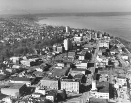
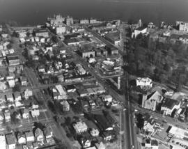
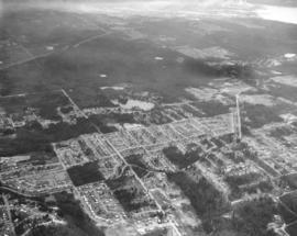
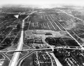
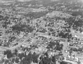
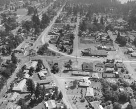
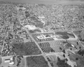
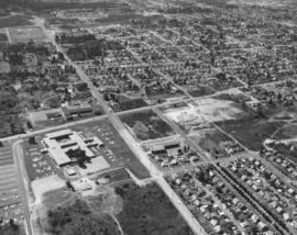
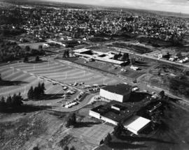
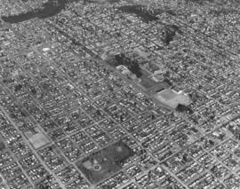
Aerial photograph in a series of North end neighborhoods on February 20, 1970. The University of Puget Sound is located on 97 wooded acres in the populous North end. It can be seen in the center of the photograph, in the 1500 block of North Warner. Jefferson Park is close by at North 9th & Monroe, near the bottom of the picture. Photograph ordered by Puget Sound National Bank.


Aerial views; University of Puget Sound (Tacoma)--1970-1980; Jefferson Park (Tacoma); Neighborhoods--Tacoma--1970-1980;

D157837-28

Aerial view looking north toward Commencement Bay on February 20, 1970. Wright Park is the wooded area at the left; First Presbyterian Church is Romanesque structure at 20 Tacoma Ave. So. The Vista Manor Apartments are located in the white 16-story building upper center. Near the Vista Manor is the Central Lutheran Church. ASARCO smokestack is near left corner. Stadium High School and Washington State Historical Society building overlooking the bay on the right. Photograph ordered by Puget Sound National Bank.


Aerial views; Neighborhoods--Tacoma--1970-1980; Wright Park (Tacoma); Commencement Bay (Wash.); Stadium High School (Tacoma); First Presbyterian Church (Tacoma); Stadium High School (Tacoma); Vista Manor Apartments (Tacoma);

D157837-26

Aerial look at the Stadium District featuring Division and 1st-3rd Streets in February of 1970. Division is the street heading in a northeast direction with Wright Park on the right. The First Church of Christ, Scientist, is at the corner of Division and "I, " across the street from the park. The dome of the First Presbyterian Church can be spotted near the top of the photograph; it is located at Tacoma Avenue So. and Division. The three streets running diagonally are 3rd, 2nd and 1st (l-r). Walker Chevrolet is the large dealership in the 600 block of Division, in the wedge shaped property. Stadium High School and Stadium Bowl are upper left center overlooking Commencement Bay. Photograph ordered by Puget Sound National Bank.


Aerial views; Neighborhoods--Tacoma--1970-1980; Wright Park (Tacoma); First Church of Christ, Scientist (Tacoma); First Presbyterian Church (Tacoma); Stadium High School (Tacoma); Stadium Bowl (Tacoma); Walker Chevrolet Co. (Tacoma);

D157008-2

New automobile unloading complex. September, 1969, aerial view of a portion of the new Milwaukee Road Union Pacific yard in Kent designed by Tacoma architects and engineers, Siefert, Forbes & Berry. The multi-million dollar complex was scheduled for dedication on October 1, 1969. Easy access from the facility was provided by the Valley Freeway and 277th St. Photograph ordered by the Milwaukee Road. (TNT 10-1-69, A-17)


Aerial views; Shipping--Kent; Railroad tracks--Kent;

D157008-10

Aerial view of new automobile unloading complex. The Milwaukee and Union Pacific were scheduled to dedicate a multi-million dollar automobile unloading complex near Kent on October 1, 1969. Highway upper portion is the Valley Freeway; road that is diagonal is 277th St. Only one of the unloading facilities is in view in the paved section. Photograph ordered by the Milwaukee Road. (TNT 10-1-69, A-17)


Aerial views; Shipping--Kent; Railroad tracks--Kent; Express highways--Kent;

D157659-1C

Aerial view of Tacoma Mall Shopping Center and Tacoma Mall Office Building. This July, 1969, view of the popular Tacoma Mall Shopping Center and newly opened six-story Tacoma Mall Office Building shows that there is still much room for development of the center. New stores would be built on both sides of the Bon Marche (red building), first occupant of the mall. The dirt acreage bordering the parking lot would eventually become extended parking for the mall and the location of Frederick & Nelson's. The Post Office would build its Evergreen Station also on Pine Street, just beyond the left edge of the photograph. Color photograph ordered by Center Offices, Inc.


Aerial views; Tacoma Mall Shopping Center (Tacoma); Shopping centers--Tacoma; Tacoma Mall Office Building (Tacoma); Parking lots--Tacoma--1960-1970; Bon Marche (Tacoma);

D148098-5

Aerials requested by Puget Sound National Bank. This February, 1966, aerial shows the land and water features just into King County. The large lake in the center of the photograph is Mirror Lake. The road running by it is SW 312th St. 1st Ave. S. is long vertical roadway extending into the trees at the left. The curving road intersecting with 1st Ave. S. is Dash Point Rd. Lakota Jr. High School are buildings located near the upper right adjoining Dash Point Rd. Looking southwesterly toward the top of the photo is the Tideflats industrial area; Hylebos Waterway is visible to the right upper corner.


Aerial photographs; Mirror Lake (Wash.);

D148297-2

Aerial view of Tacoma Boat Building Co. facility on Sitcum Waterway as it looked on March 28, 1966. Started by Haldor Dahl and Arne Strom in 1936, Tacoma Boat Building received many contracts for government vessels and fishing boats. The plant was completely destroyed by fire on August 17, 1968; at $3,905,750, it was the largest single loss fire in the Tacoma Fire Department's history. Photograph ordered by Tacoma Boat Building Co. TPL-9122


Aerial photographs; Tacoma Boat Building Co., Inc. (Tacoma); Boat & ship industry--Tacoma--1960-1970;

D148857-1

June 4, 1966, aerial view of portion of Tacoma Tideflats featuring the Tidewater Oil Co. with Puget Sound Plywood plant in rear. Tidewater's winged "A" is clearly visible on one of the large storage tanks on the Tacoma plant's property. Located west of the Middle Waterway, the close proximity to water would make transport of oil products from its docks efficient. Oil could also be loaded onto trucks or by rail. Photograph ordered by Tidewater Oil Co.


Aerial photographs; Tidewater Oil Co. (Tacoma); Puget Sound Plywood, Inc. (Tacoma); Storage tanks--Tacoma; Piers & wharves--Tacoma--1960-1970;

D148299-1

The National Bank of Washington opened its $800,000 electronic center in April, 1965, at 1015 Center St. Tacoma architects Lea, Pearson & Richards designed the building which was built by John Lade, contractor. This aerial view, taken on February 14, 1966, shows the multi-storied building with large electronic sign. Goodwill Industries, visible on nearby So. 27th St., was built and designed by the same people responsible for the electronic center; it also opened in 1965. Tacoma's industrial Tideflats area can be seen indistinctly in the horizon. Photograph ordered by National Bank of Washington.


Aerial photographs; National Bank of Washington (Tacoma); Banks--Tacoma; Goodwill Industries, Inc. (Tacoma);

C148862-4

ca. 1966. Copy of customer's print. Closer aerial view of the new Tacoma Mall Shopping Center ca. 1966. The Tacoma Mall had expanded to 70 stores when it opened officially in October, 1965. It touted the 7000+ parking spots available to shoppers without charge and this ca. 1966 photograph indicates that thousands would take advantage of the easy parking and climate-controlled enclosed mall. Downtown merchants and officials would try to counter with ads remarking on the variety of choices a downtown shopper would have with competition keeping prices reasonable and meter maids were even putting extra nickels into parking meters to give customers a bit more time to shop. Still, the lure of the modern roofed mall would be hard to resist for thousands of shoppers from Olympia to Seattle. View of expanded Tacoma Mall with Bon Marche on center right, J.C. Penney's in center left, National Bank of Washington circular bank building at lower left. Nordstrom-Best would be the next large company to join the mall, opening in August, 1966. Photograph ordered on June 7, 1966, by Bank of California.


Aerial photographs; Tacoma Mall Shopping Center (Tacoma); Shopping centers--Tacoma; Bon Marche (Tacoma); J.C. Penney Co. (Tacoma); National Bank of Washington (Tacoma);

C148862-3

ca. 1966. This aerial view of Tacoma south of the I-5/ South 38th Street interchange was taken several months after the Tacoma Mall Shopping Center had its grand opening in October 1965. The Mall, with some 70 stores including J.C. Penny, Kress, a Thriftway supermarket and the Bon Marche, offered parking for 7,000 cars. The bright area above and to the left of the 56th Street cloverleaf is Wapato Lake. The housing area at the bottom, to the right, is Lincoln Heights. When this photograph was taken the Mall was an island of commercial property surrounded by residential housing. (Photograph ordered on June 7, 1966, by Bank of California.)


Aerial photographs; Express highways--Tacoma--1960-1970; Tacoma Mall Shopping Center (Tacoma); Shopping centers--Tacoma--1960-1970; Wapato Lake (Tacoma); Neighborhoods--Tacoma--1960-1970;

D149017-7

Aerial view of Fox Island's southern end. This August 16, 1966, photograph shows that the island is virtually covered with dense forests. There are very few buildings on the island's south end; most appear to be close to the water. Photograph ordered by Swanson-McGoldrick, Inc.


Aerial photographs; Fox Island (Wash.); Forests;

D149017-5

Aerial view, looking east, of Tacoma waterfront and surrounding neighborhoods on August 16, 1966. Northern Pacific Rail tracks curve alongside waterfront. Sperry Flour plant with dock on right-center. Photograph ordered by Swanson-McGoldrick, Inc.


Aerial photographs; General Mills, Inc., Sperry Division (Tacoma); Piers & wharves--Tacoma--1960-1970; Railroad tracks--Tacoma--1960-1970; Waterfronts--Tacoma--1960-1970; Neighborhoods--Tacoma--1960-1970;

D149142-4

Lake City seen in miniature from the air on August 7, 1966. The Lake City neighborhood continued to grow in the mid-60's but there were still many pockets of forested areas visible. Neighborhoods in the Lake City/Lakewood area tended to have larger lots and a more suburban feel. This view appears to have been taken looking north-northwest from the American Lake area, including Veterans Drive S.W. Washington turns into Military Road in upper center of the photograph. Carp Lake is lake above Military Road; large lake at top of photograph is Lake Louise. The Lake City Community Church is the building with the white roof along the right edge near center. Just above it is the Lake City Community Center. On the lower left is visible a portion of the parking lot for the American Lake Park North. Below the curve in the road, just below the center of the photograph, is the Veterans Garage. Photograph ordered by Bank of Tacoma. (Additional information provided by a reader)


Aerial photographs; Neighborhoods--Lake City; Carp Lake (Wash.); Lake Louise (Wash.); Lake City Community Church (Lakewood);

D149142-1

Aerial view of Veterans Drive S.W. area of Lake City taken on August 7, 1966. Shop-Rite Food Center with a few cars parked in front is at right-center. The Veterans Garage is located nestled in the wide curve closer to left-center. Buildings in left corner are part of a neighborhood school. Tip of American Lake can be spotted beyond the trees in right corner. Photograph ordered by Bank of Tacoma.


Aerial photographs; Neighborhoods--Lake City; Shop-Rite Food Center (Lake City); Veterans Garage (Lake City);

D149017-8

View by air of the southern end of Fox Island. This is a closer look, taken in August, 1966, of the quiet, heavily forested island. Some islanders have chosen to build their homes with beautiful waterfront views. Photograph ordered by Swanson-McGoldrick, Inc.


Aerial photographs; Fox Island (Wash.); Forests;

D149224-5

July, 1966, aerial view of the Spanaway-McChord area. McChord AFB to the right; two planes visible on McChord Field. Lake in upper center is Spanaway Lake. The Richards photographer was supposed to take views of Frederickson as well; however, heavy smog prevented this from occurring. Photograph ordered by Puget Sound National Bank.


Aerial photographs; McChord Field (Tacoma); Spanaway Lake (Wash.);

D149142-2

Looking south on Veterans Drive S.W. in Lake City as seen by air on August 7, 1966. The wide, curving road travels past the Veterans Garage, lower-left center, and continues past the Shop-Rite Food Center, large building on left side of Veterans Drive. Lake at the top of the photograph is American Lake; two float planes are visible at the boat launch. Park close by is the American Lake North County Park. Photograph ordered by Bank of Tacoma.


Aerial photographs; Neighborhoods--Lake City; Shop-Rite Food Center (Lake City); Veterans Garage (Lake City); American Lake (Wash.);

D149404-5

Aerial view of St. Regis Paper Co. 's distribution center in Issaquah on August 11, 1966. Piles of plywood are stored both under cover and stacked neatly out in the open. The company's name is prominently displayed on the large plant roof. The new facility distributes building material supplies. Company officials indicated that the distribution center is located in an area where officials foresee high growth potential. Photograph ordered by St. Regis Paper Co. (TNT 9-4-66, A-10)


Aerial photographs; St. Regis Paper Co. (Issaquah);

D149224-8

This aerial photograph taken on July 22, 1966 showed the westward view of the So. 19th & Union Ave. neighborhood. The new Elks Temple, 1965 So. Union Ave., with its enormous parking lot was right of Union. It was next to the new Allenmore Medical Center. The open area next to the Elks would eventually become the site of retail and office buildings. Franklin Park was located at the upper center of the photograph, at approximately So. 12th & Puget Sound. The H-shaped apartment complex at 1902 So. Union was the Unionaire Apartments, built by Lundstrom Building Enterprises. Photograph ordered by Puget Sound National Bank.


Aerial photographs; Neighborhoods--Tacoma--1960-1970; Allenmore Medical Center (Tacoma); Unionaire Apartments (Tacoma); Benevolent and Protective Order of Elks, Tacoma Lodge No. 174 (Tacoma);

D149224-17

Mount Rainier peeks through a blanket of clouds in this July 22, 1966, aerial view of the Tacoma Narrows Bridge and the city's west end including the Titlow Beach area. Mount Adams is almost totally obscured to Rainier's right. I-5 runs along the photo's horizon. Sixth Avenue leads directly onto the Narrows Bridge. Jackson intersects with Sixth just prior to the long bridge entrance. Tacoma Community College in the 5900 block of So. 12th had just finished its first year of existence; the school, located on a 40-acre plot, is about mid-center in the photograph. Photograph ordered by Puget Sound National Bank. TPL-10541


Aerial photographs; Tacoma Narrows Bridge (Tacoma); Bridges--Tacoma--1960-1970; Suspension bridges--Tacoma; Rainier, Mount (Wash.); Tacoma Community College (Tacoma);

D149224-6

Aerial photographs of the So. 19th & Union Ave. looking west toward So. 19th and surrounding north end neighborhoods. The 46-unit apartment complex, Boyd Lundstrom's Unionaire, is H-shaped building with dark roof. It is across the street from the year-old Allenmore Medical Center complex, 1901 So. Union Ave. The medical-dental building with a 50-bed hospital opened in the summer of 1965. The fully airconditioned edifice was built at a cost of approximately $1,300,000. It was conveniently located with direct access to the freeway and Narrows Bridge route. Photograph ordered by Puget Sound National Bank who would later build a branch at 3501 So. 19th, across the street from Allenmore .


Aerial photographs; Allenmore Medical Center (Tacoma); Unionaire Apartments (Tacoma); Neighborhoods--Tacoma--1960-1970;

D149017-1

This aerial view of the Northern Pacific Railroad tracks which run along the edge of Commencement Bay just south of Old Tacoma, and adjoining northend neighborhoods, dates from August 1966; before the Schuster Parkway was built. The Sperry Flour grain elevators, located at what is now 3 Schuster Parkway, were located next to the tracks. The General Mills, Sperry Division, had closed in 1965. The plant's grain towers were torn down in 1973 and its deteriorating dock, the last portion of the mill, was demolished in 1989. Work on Schuster Parkway began in 1973 and was completed in 1976. Photograph ordered by Swanson-McGoldrick, Inc.


Aerial photographs; General Mills, Inc., Sperry Division (Tacoma); Piers & wharves--Tacoma--1960-1970; Railroad tracks--Tacoma--1960-1970; Neighborhoods--Tacoma--1960-1970; Waterfronts--Tacoma--1960-1970;

D149142-3

Another aerial view ordered by Bank of Tacoma of the Veterans Drive S.W. neighborhood in Lake City. Taken on August 7, 1966, a glimpse of American Lake can be spotted in the left upper corner. The county park is located in the vicinity of the lake. Veterans Drive is the curving roadway in the center of the photograph. Military Road is believed to be street on right side of photograph.


Aerial photographs; Neighborhoods--Lake City; American Lake (Wash.);

D149142-5

Closer view of the Lake City neighborhood including Veterans Dr. S.W. on August 7, 1966. American Lake in upper left corner. Washington is the street on extreme right. Photograph ordered by Bank of Tacoma.


Aerial photographs; Neighborhoods--Lake City; American Lake (Wash.);

D150900-357

1967 Richards stock file. Aerial view of the So. 19th & Union Ave. neighborhood taken on October 28, 1967. This view looks toward So. Union. The massive Elks Temple is in the foreground with Allenmore Medical Center in center. The Elks membership had moved from its Broadway location, built in 1916, to this north end neighborhood near Allenmore Golf Course in 1965. The Allenmore Medical Center, also opened in 1965, was a medical-dental building with a 50-bed hospital. It was built on a 22-acre tract on what had been part of the old Allenmore golf course. The $2,000,000 center was designed by E.L. Mills & Associates and built by Norman Strom Construction. Wooded area across So. 19th from Allenmore would eventually become a Puget Sound National Bank branch (now Key Bank). TPL-9324


Aerial photographs; Elks Temple (Tacoma); Benevolent and Protective Order of Elks, Tacoma Lodge No. 174 (Tacoma); Allenmore Medical Center (Tacoma);

D150975-7

Aerial view on February 22, 1967, of City (now Thea Foss) Waterway which separates downtown Tacoma from the industrial Tideflats area. The waterway is partially filled with many log booms. Schoenfeld's massive furniture store can be glimpsed in the left hand corner of photograph. The larger of the two bridges shown is the 15th St. Bridge which is no longer there. Long roadway to the right of waterway is D St. The Museum of Glass would be built across the waterway on Dock St. next to Albers Mill in 2001. Photograph ordered by D Street Rafting Co. TPL-8826


Aerial photographs; City Waterway (Tacoma); Logs;

D150900-358

1967 Richards stock file. Aerial view of new Kmart department store, 5132 Sixth Ave., with nearly full parking lot, taken on October 28, 1967. Kmart was located next to Busch's Sixth Ave. Drive-in and across the street from the First Christian Church. G. Kirkebo & Sons were general contractors; architect was E.D. McCarthy of Spokane. The 105,000 square foot building was situated on a 10.5 acre site with parking for 1000 cars. (TNT 1-23-67, p. 7)


Aerial photographs; Kmart (Tacoma); Department stores--Tacoma--1960-1970; First Christian Church (Tacoma); Busch's Sixth Avenue Drive-In Restaurant (Tacoma);

D150900-352

1967 Richards stock file. Aerial photographs of the University Place neighborhoods surrounding 40th & Bridgeport Way were taken on October 28, 1967. This area was still heavily wooded. Building complex on the right side of photograph is the University Village Shopping Center which was scheduled to open in October, 1967. Food King supermarket and Don's Village Drugs would be major clients of the shopping center. At the bottom of the photograph is the University Place water tower which had been remodeled in 1964 to hold 400,000 gallons.


Aerial photographs; Neighborhoods--University Place; Shopping centers--University Place; Food King (University Place); Water towers--University Place;

Results 241 to 270 of 824