Print preview Close

Showing 1616 results

Collections
Image
Advanced search options
Print preview View:

1616 results with digital objects Show results with digital objects

Map of Oregon, Washington, Idaho, and Part of Montana, 1860

Philadelphia : S. A. Mitchell, Jr.
1 map : hand col. ; 27 x 34 cm. Relief shown by hachures. Shows counties, cities, railroads, routes of wagon trails, and rivers. Scale ca. 1:4,435,000. Lower right: 50. Decorative border. Dated 1860 in bottom margin, but some question whether that might be the date of the original copyright of the base map.

Johnson's Washington and Oregon, 1863

New York: Johnson and Ward
1 map : hand col. ; 32 x 40 cm. Relief shown by hachures. Shows counties, cities, locations of native American tribal groups, and proposed railroad. Scale ca. 1:3,500,000 On verso: portion of "Historical and Statistical View of the United States, 1860", tables for Vermont, Virginia and Washington. In lower right margin: 57. Decorative border. Oregon counties Jackson and Josephine have been interchanged.

View of the City of Tacoma, W.T., Puget Sound, County Seat of Pierce Cty., Pacific Terminus of the NPRR, 1884

Madison, Wis. : J. J. Stoner; Ithica, N.Y. : Historic Urban Plans
1 map; 31 x 83 cm. Bird's-eye view. Perspective map not drawn to scale. Oriented with North to lower right. Includes key to points of interest. "Reproduced ... from an engraving in the Library of Congress." Includes inset of "Mount Tacoma, 14,444 ft. high." "Beck & Pauli, Litho., Milwaukee, Wis."

Map Showing Land Grant of the Northern Pacific Railroad Co. in Western Washington and Northern Oregon, 1887

Buffalo, N.Y. : Matthews, Northrup & Co., 1887.
1 map; 78 x 80 cm. Damaged and taped, mounted on linen backing. Shows drainage, railroads, county boundaries, townships, sections and quarter sections, railroad lands sold and unsold, government lands, school sections, etc. Inset: map showing "Northern Pacific Railroad, Oregon R. W. & navigation and Oregon & California Co. S. Systems". Relief shown by hachures and spot heights. "Scale 6 miles to one inch" (1:380,160)

Auburn--General - 7

Back of Photo:
Portway's Store about 1886 or 1887. Purchased from L.W.B., the first business building in what is now Auburn. Building later renamed and known as Star Hotel.

Indians, Puyallup (History) - 1

Back of Photo:
Yesteryear Feb. 7, 1986
Puyallup Indian Tribe members gathered on Feb. 9, 1891, as part of their monthly neighborhood meetings. This was the time when Indian families gathered to discuss the business of running the reservation and making improvements in the quality of life. The women were not generally included in business affairs of the tribe, which would explain their absence in the photograph.
State of Washington Views
Rutter, Photo
Tacoma, Wash.

Caledonian and St. Andrews Societies (Robert Burns)

"Robert Burns: The Oration" by Albert E. Joab booklet of 26 pages. Title page: "Robert Burns: Peasant, Poet, Patriot. An Oration, Delivered Before the Caledonian and St. Andrew's Societies of Tacoma, Washington, on the One Hundred and Thirty-Eighth Anniversary of the Poet's Nativity". c. 1897.

Inside the booklet is a program titled "Concert and Social will be held on the anniversary or Robbie Burns' Birthday. Friday, January 24th, 1890 at 8 p.m. in Bush's Hall, 1131 1-2 Tacoma Ave."

Topographic Sheet, Washington, Tacoma Quadrangle, 1898

Washington : Geological Survey
1 map : col. ; 45 x 31 cm. on sheet 56 x 47 cm. "Surveyed in 1894-95." Scale: 1:125,000 Contour interval 50 feet. Relief indicated by contours and spot heights. Datum is mean sea level. "Edition of Nov. 1898" Engraved April 1897 by U.S.G.S. Henry Gannett, Chief Topographer. R. U. Goode, Geographer in charge. Control by W.T. Griswold and U.S. Coast and Geodetic Survey. Topography by G.E. Hyde and R.H. McKee. Diagram depicts which topographers were responsible for which areas of the map.

Map of Washington, 1904

George F. Cram and Company
1 map; 34 x 51 cm. From page 292-293 of Cram's unrivaled atlas of the world. Relief shown by hachures. Shows counties, cities and railroads. Scale ca. 1:1,300,000 On verso: portion of "City of Portland, Oregon." In lower margin: 292, 293. Index on verso.

WIL (D)-124

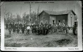
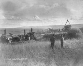
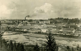
ca. 1908. A scene in the Big Bend, circa 1908. Threshing 3 miles south of Waterville, Washington. This area of north central Washington State was a wheat farming community. The fertile soil, dry summers and heavy snows in winter produced abundant crops. During the past season circa 1907, however, wheat ran from twelve to thirty bushels per acre, a lighter yield than normal but as prices remained good, the farmer did not lose in the long run. The town of Waterville became the Douglas County seat in 1887, and according to its Chamber of Commerce, farming remains a mainstay of the local economy. The Wilhelm Collection (Coast Magazine September 1908, p. 153-157-article on Waterville) TPL-4273


Photographer: Witter, Alfred S., Waterville

Immigration and Emigration - 2

Back of Photo:
"August Anderson clearing land." C1910, Lakebay, Washington
Courtesy of Mr. & Mrs. Gustaf Loustrom, Tacoma, WA

From In the Footsteps of Nicholas Delin: the Swedish Presence in Pierce County, a photography exhibition tracing the world of Swedish and Swedish-Finnish immigrants in Pierce County from 1887 - 1930, opening Thursday, December 14, 1995 at the Tacoma Public Library's Handforth Gallery (Main Library, 1102 Tacoma Avenue South in downtown Tacoma).

Map of Washington, 1911

George F Cram Company
1 map; 34 x 41 cm. From page 178-179 of Cram's unrivaled atlas of the world. Relief shown by hachures. Shows counties, cities and railroads. Scale ca. 1:1,300,000 On verso: "Alaska" and "Idaho" maps. In lower margin: 178, 179.

Rand McNally New Commercial Atlas Map of Washington, 1912

Chicago : Rand McNally.
1 map : col. ; 48 x 66 cm. State capitals and County seats identified by symbols. A key to Railroads is located in the lower left. Shows Railroads and Steamship lines. Includes index of cities with a population of 1,000 or more. At top: "Library atlas of the world." Relief shown by hachures and spot highlights. Scale 1 in. = 15 miles [ca. 1:950,400].

Immigration and Emigration - 1

Back of Photo:
Theatrical Group, Order of Vasa, ca. 1912, Tacoma
Photograph courtesy of the Vasa Lodge Norden, Tacoma

From In the Footsteps of Nicholas Delin: the Swedish Presence in Pierce County, a photography exhibition tracing the world of Swedish and Swedish-Finnish immigrants in Pierce County from 1887 - 1930, opening Thursday, December 14, 1995 at the Tacoma Public Library's Handforth Gallery (Main Library, 1102 Tacoma Avenue South in downtown Tacoma).

"Tilley-O" (Chapter 15 Image 178)

ca. 1928. "Tilley-O"- multiple exposures of a smiling woman in sepia toned and B & W. This circa 1928 photograph shows exposures of the same woman placed in a circular format with what may be a mound of thickish black hair in the center of the circle, thereby either hiding the woman's actual hair or was an enlargement of her hair. (Virna Haffer Collection) (Bullock: A Turbulent Lens, p. 40-picture only)

"Kwei Dun"

ca. 1929. Digitized for use by Frye Museum/jg. This is entitled "Kwei Dun" and was a bromoil print which resembled a painting. This is believed to be a portrait of Chinese finger painter Kwei Dun who arrived in Seattle in 1924 to study art and architecture at the University of Washington. (Virna Haffer Collection) (Bullock: A Turbulent Lens, p. 107)

"Kwei Dun"

ca. 1929. Digitized for use by Frye Museum/jg. This painting-like piece is listed as "Kwei Dun" according to the book "A Turbulent Lens." A black and white version can be seen at series VH, image KWEI. The circa 1929 portrait was made of Chinese finger painter Kwei Dun who had traveled to Seattle to study art and architecture at the University of Washington. (Bullock: A Turbulent Lens, p. 107)

Results 1 to 30 of 1616